AJ Baker and FR Young. Digital Mapping Data Currency Through Sharing: A Practical Study.
Proceedings of SSC 2005 Spatial Intelligence, Innovation and Praxis: The national biennial Conference of the Spatial Sciences Institute, September 2005. Melbourne: Spatial Sciences Institute. ISBN 0-9581366-2-9
DIGITAL MAPPING DATA CURRENCY THROUGH SHARING: A
PRACTICAL STUDY
Mr AJ Baker
1and Associate Professor FR Young
21
Land and Property Information Division, NSW Department of Lands, Panorama Avenue
BATHURST. NSW. 2795
2
Head, Surveying and Land Information, Faculty of Engineering and Surveying, University of
Southern Queensland, TOOWOOMBA QLD. 4350
KEYWORDS: Data Currency, Data Sharing, Topographic Mapping.
ABSTRACT
Organisations began sharing information long before the introduction of computers and GIS and whilst the data-sharing task has become less arduous due to their continued evolution, this has also increased the complexity. The quantity of shared data has risen markedly over the last decade. This is in addition to the demand for data to be not only spatially accurate but also up to date in both content and currency.
Since the late nineteen eighties cadastral information has been actively maintained in all Australian States through the use of Digital Cadastral Data Base’s (DCDB). Up to date cadastral information is available to customers in the form of incremental updates. Despite each state also maintaining their topographic information (DTDB), a similar mechanism does not presently exist.
With the background of current data sharing practices and relevant local and overseas examples this paper outlines the results of a recently completed data sharing study. This study proposed a conceptual model for topographic map production through the use of data sharing and incremental updates.
BIOGRAPHY
Tony is a senior technical adviser within the Land and Property Information Division of the NSW Department of Lands in Bathurst.
Over his career he has gained experience in many facets of cartography including the digitisation of the NSW cadastre, the production of customised products, and the compilation of standard topographic maps. He recently completed his Master of Geomatics from the University of Southern Queensland after previously gaining qualifications in both cartography and environmental science.
BACKGROUND
Maps become out of date due to the natural and built environments changing faster than maps are being revised. Whilst there is a steady demand for up to date natural resource information by government and the private sector, there are not enough (coordinated) resources available to enable the mapmakers to keep abreast of the changes. This point is further highlighted with McRae and Walker [2000] stating that whilst topographic maps were “an invaluable planning and operational support tool” they had some serious shortcomings relating to currency and relevance. These shortcomings include the temporal accuracy of the information and the level of usability that the user wanted.
Existing approaches to updating topographic databases include supplying change only information, or a total resupply of existing data. Beyen & Henrion [1998] suggest that there is a growing need to preserve the historical perspective of the data. This is further supported by Brand [1998] who suggests that little consideration has been given during database design to maintenance in terms of currency, presentation and archiving. Beyen & Henrion [1998] also suggest that the change only alternative has the potential to suffer from both human errors and software problems.
Dangermond [1999] offers a different and very interesting view with “The Geography Channel” monitoring the daily change in the world. This would operate similar to the nightly news that exists currently. This supports the views of the Open Space Forum at AURISA 1996 that discussed what customers want in data with respect to the four C's [Veenendaal et al., 1997]. These being consistent, complete, current, and correct.
The technologies available for data collection, feature identification and map production have advanced steadily over the last ten years. However, this has also resulted in a duplication of effort and resources that has ultimately increased the cost to government through the inefficient use of equipment and trained staff, and a subsequent reduction in client services. It is also apparent that whilst the technology has advanced, so has the community expectation in relation to maps and map related data and services. This rising expectation and the reduction in client services offer little relief to a “map hungry” public in need of the latest information supplied in formats and in timeframes of their choosing. This presents a number of issues to the mapping community where data collection mechanisms at present are unfortunately not designed with data currency in mind. Production schedules have adopted a schema with “the map” as the central focus rather than its individual components. In short, maintain the map, by maintaining the data.
The demand and economics of topographic map maintenance, to ensure data consistency, completeness, currency and correctness, requires a sharing based production model aimed at continuously maintaining the topographic data base.
DATA SHARING PRACTICES
[image:2.595.107.488.651.724.2]The Queensland Spatial Information Infrastructure Council model has been designed to address some of the previously expressed concerns and its implementation has resulted in a high degree of cooperation between the various sectors. This is especially relevant as “Government is typically the ultimate source of most core or commonly used spatial data” [Rhind 1995]. In many countries however, topographic mapping is carried out under military mapping agency control and due to their present political climate is considered “sensitive”. As detailed and accurate data becomes increasingly available over their individual regions, some countries have amended their national policies as the benefits of civilian and social uses are being recognised [Sorensen 2000].
These benefits, which have long been recognised, have led to the introduction of a series of agreed responsibilities for the various levels of government in Australia (refer table 1). It can be seen that there is a spatial nature to all of the themes represented. Specifically, based on these various levels of responsibilities, several potential data sources immediately emerge within NSW (refer table 2).
Federal State Local
Taxation Law Enforcement Town Planning
Defence Education Local Roads
Trade and Foreign Affairs Transport Rates
Social Security Health Services Local Environment
Astronomical Observations and Navigation Land Management Essential Local Infrastructure
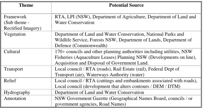
Theme Potential Source
Framework (Sub theme - Rectified Imagery)
RTA, LPI (NSW), Department of Agriculture, Department of Land and Water Conservation
Vegetation Department of Land and Water Conservation, National Parks and Wildlife Service, Forests NSW, Department of Lands, Department of Defence (Commonwealth)
Cultural 170+ councils and other planning authorities including utilities, NSW Fisheries (Aquaculture Leases) Planning NSW (Developments on line), Acquisition and Disposal of Government Land.
Transport Local council / RTA (roads), Rail Estate (rail), Federal Dept of Transport (air), Waterways Authority (water)
Relief Local council / RTA (cuttings and embankments associated with roads), Local council (development that alters contours / DEM / DTM) Hydrography Department of Land and Water Conservation
[image:3.595.134.463.69.245.2]Annotation NSW Government Gazette (Geographical Names Board, councils / or government agencies, Road Names)
Table 2: Potential Data Sources within NSW
Cooperative mapping /sharing:
The NSW Department of Lands has negotiated a series of cooperative mapping arrangements for the topographic map sheets along the state borders with Victoria, South Australia and Queensland. These arrangements detail the production of individual topographic maps along the state borders by the various state mapping agencies. The updates for all agencies are, however, only requested at the time of map production. All sixteen recently produced topographic maps (1:25000) covering the ACT were produced, utilising ACT government data where applicable, by the NSW Department of Lands in a cooperative arrangement.
The Western Australian Land information System (WALIS) was established in the late 1970’s [Grant 2000]. It is a consortium rather than a single database and has been developed to provide all users with access to the total combined data held by all WALIS agencies. A similar system is presently being developed in NSW by the Department of Lands Emergency Coordination Unit (EICU). Their aim is to ensure that emergency service organisations (ESOs) have the best spatial and related spatial data available to deal with multi agency emergencies, such as terrorism.
The EICU, despite being set up as a counter-terrorist initiative, provides commonality in the data required by ESOs for bushfires, floods, earthquakes, storms, and criminal activities, and aims to implement and maintain a collaborative data sharing system on behalf of Emergency Service Organisations (ESOs).
Overseas Examples
Prior to the early 1960’s, Hong Kong was mapped at scales of 1:600 and 1:1200 with no height or contour information and resembled a “planimetric record”. Between 1962 and 1971, 1:600 scale maps were produced covering Hong Kong Island, Kowloon and New Kowloon with 5-foot contours and 1:1200 scale maps covering the new territories. With the adoption of a metric system in the early 1970’s, a standard 1:1000 scale was adopted requiring the conversion of approximately 3000 sheets.
Continuous revision is carried out with priority given to areas of greatest commercial activity and development. A survey intelligence system has been set up to collect information on proposed construction projects and other major works, with the system recording the project’s anticipated completion dates. As this information is used to plan the map revision programmes, major changes can be updated on site within a short period of the projects completion. The implementation of computer-based mapping has assisted in the planning of the country’s revision program and has made up-to-date plans readily available [Hong Kong Government 2002]. Through continuous improvement, the 1:20000 Topographic Map Series may strategically capture every real world change as soon as the information becomes available [Gan et al., 2000].
Considerable duplication of effort has occurred due to Geomatics Canada, the Canadian Hydrographic service and the provincial mapping organisations producing and maintaining datasets for both Pacific and Atlantic coastlines [Coleman 2000]. Data sharing arrangements are now in place between the agencies and include both coastlines and the federal use of provincially prepared road network datasets.
Incremental Updates
The Intergovernmental Committee on Surveying and Mapping (ICSM) has drawn up guidelines for data to be included in the Australian Spatial Data Infrastructure (ASDI). Incremental update capability is a component of the model for data compliant with the ASDI.
..a data transfer system that enables suppliers to supply only information that has been affected by change between two versions of a dataset and for users to be able to incorporate those changes into their data..
[ICSM 2003].
Jacoby et al. [1997] discuss versioning and temporal management within the Victorian DCDB. This model uses time date stamping and features are retired rather than deleted when they are no longer required. Incremental updates are an essential component in the hydrographic mapping field and the production of electronic navigation charts (ENC). Hardy et al. [2000] outline the importance of database maintenance through the use of versioning toolkits within object orientated spatial databases.
Parallels can be drawn between digital cadastral databases (DCDB) and topographic databases in terms of incremental updates and data resupply.
..to maintain the currency of the DCDB continual subdivision activity must be captured by the custodians..
[Effenberg et al., 1996]
Previous research has also explored the suitability of the Internet for updating cadastral databases [Polley et al., 1997]. With the technological advances of recent years, this theory may become a reality and provide sufficient capability for topographic updates as well. One such innovation includes the introduction of unique topographic identifiers (TOIDs) by Ordnance Survey in Great Britain for easing the task of associating different datasets to Ordnance Survey base material.
DATA SHARING STUDY
Data was collected and analysed throughout the 28 week final data collection component of the study. This data comprised information from the weekly copies of the NSW Government Gazette, and additional information obtained through successful data sharing activities. NSW Fisheries, Gunnedah Shire Council, and Forests NSW represented both local and state tiers of government and provided data and expertise throughout this stage.
The study was able to show conclusively that government agencies are aware of changes in the natural and built environments and that this information, when made available, would streamline topographic database maintenance. It was also found that topographic maps and products could be maintained more efficiently, utilising data provided incrementally as part of a data sharing arrangement. These efficiencies would develop from the utilisation of temporally accurate data obtained from the various data custodians, who would each be regarded as experts in their individual fields and areas of interest. This data would have increased reliability and would require less verification prior to database insertion. Savings would also be achieved with additional time and resources being available for data collection rather than for the verification of other government datasets.
From the analysis of 28 weeks of published data from the NSW Government Gazette and through the successful data sharing activities with three government bodies, results and conclusions were obtained that provided additional support and further substantiated the “Now Map” concept.
CONCEPTUAL MODEL - ENHANCED TOPOGRAPHIC MAP PRODUCTION
The proposed model (refer figure 1) uses data sharing programs as a source for incremental updates. The supply of temporally accurate data, provided earlier than available under current arrangements, will improve future topographic map production and provide for the “maps on demand” style products. To accommodate the implementation plan, the participants need to be identified, along with the potential sources and methodology for incremental updates. The participants consist of two very distinct groups of people, those who are feature users and those who are the data custodians.
The feature users are individuals or organisations that:
• Use geographic information, as part of their core business, or as part of an interest or hobby, and/or • Change topographically significant features, and/or
• Determine that features or data have changed, and are not data custodians.
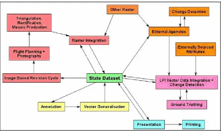
[image:5.595.81.515.383.640.2]The data custodians are individuals or organisations that maintain data as part of their own core business. This maintenance program usually includes a dedicated update and data resupply strategy. It is the identification of these custodians that is the key to the models success. Without knowing whom to source data from, it would be very difficult to have the most up to date information available for inclusion in the map production process. Demonstrating the model’s benefits and suitability will increase the number of interested partners, and in turn increase the known data custodians and partnerships available as well.
Figure 1: Topographic Data Integration Framework
Current examples include:
• Local Government Health and Building Surveyors, • Postal Contractors,
• Workcover, RTA, and Fisheries Inspectors, • Department of Mineral Resources Geologists, • Government surveyors,
• Soil conservation field staff, • Emergency Services Staff, and
• Electricity meter readers and maintenance workers.
The planned structure and usage protocols of the implemented data supply and delivery system must also be considered. A single logically consistent database for all government information, providing as a minimum the functionality of the WALIS and EICU models, would potentially solve several of the concerns regarding data storage, the transfer of updates, licensing and copyright.
Implementation Plan
The model’s implementation undertakes a five-stage plan.
ONE: Data Authority Identification. The first stage is to identify which organisation is best suited to be the authority for a particular type of data. This decision would be based on an organisation’s expertise and legislative responsibilities. It should be noted that an organisation’s previous ability to produce hardcopy products does not automatically qualify it to be the particular data authority for the data used to make those products today.
TWO: Data Consolidation / Redistribution. After a consultative process between the present data custodians,
agreement will be reached on which organisations are to become the new data authorities. The data and resources are then redistributed and where necessary consolidated by the new authority.
THREE: Persistent Identifier Allocation. For each feature held within each theme, the data authority allocates a
“persistent identifier”. These are used to identify the feature uniquely within the state with blocks of alphanumeric identifiers being used by each authority. This allocation would be carried out similar to that already in use in Britain for buildings (TOIDs). The identifier, once allocated, remains with the feature and is not reallocated on retirement.
FOUR: Data Redistribution. Once the allocation of persistent identifiers is completed, the data authority redistributes all relevant data with identifiers and attribute tables attached to all interested (previously identified) parties.
FIVE: Incremental Update. After the redistribution of data by the data authorities, the individual incremental update programs are able to commence using the relevant feature users and data authorities.
Assessing Future Custodianship
For each feature held within the various government agencies, there are important questions that need to be answered when assessing custodianship.
• Is it topographically significant? • If so, at what scale or range of scales?
• How would the feature be shown at these scales? • Who knows about the changes in these features? • Of these, who is the primary custodian?
• Who initiated the change if it wasn’t the primary custodian?
• Is the primary custodian the person or organisation best able to maintain the data, or is an alternative required? For example, mangrove data is collected by LPI as part of the topographic map program despite having few staff trained in its identification. NSW Fisheries have trained staff, but almost no capability to provide map related data at topographic production scales.
Prior to the model’s implementation, three major points need to introduced and discussed. Firstly, the creation of a coordinating body within the mapping and surveying industries. Secondly, the role reversal that some organisations would have to undertake or experience as part of the implementation, and thirdly, the most significant of all, the modification to the individual database structures that presently exist within each government organisation.
In NSW, the surveying industry is coordinated by the Surveyor General and the Board of Surveyors and Spatial Information (BOSSI). To assist in the implementation and coordination of the model, two alternatives are considered. Firstly, the further expansion of the coordinating role presently undertaken by BOSSI would be required. Alternatively, the introduction of a dedicated spatial information coordination body, with the sole responsibility of coordinating and managing government spatial data collection, maintenance, and supply. The organisation could be named, for example, NSW Spatial Coordination Authority. With the introduction of a separate organisation, BOSSI would be able to concentrate on the registration, professional development, and management of surveyors.
Some organisations have always been data suppliers, whereas in the model they may be suppliers, customers or both. Due to this potential role reversal there would need to be a review of government spatial collection processes, data management procedures and the provision of client services. This review would be undertaken during the assessment of the current data custodians.
In addition, most organisations will have to introduce point level date stamping using a start and finish date for each feature, for example: feature id, start_date, finish_date.
The incremental update strategy relies on organisations retaining data that has been deleted through the use of retirement dates. As a result of the date stamping, the long-term benefit is that in the future this will also allow for the creation of temporal scene (historic) maps using time slicing.
All data custodians would be required to allocate persistent identifiers (refer stage three of implementation plan) to the data in their care, ensuring that duplication of identifiers within the “whole of government” arena does not occur. By allocating blocks of alphanumeric identifiers to each government agency involved, regardless of tier, this should not occur. Data custodians would also be required to establish appropriate data transfer and storage standards and formats. These will also be used in establishing appropriate verification methodology and spatial data matching techniques, required for maintaining a standard in the form of accurate spatial data. These techniques would be shared with all agencies within the data sharing arrangement for the purpose of maintaining at a minimum the present topographic data standard.
Model Partners
The proposed topographic production process (refer figure 1) utilises data from the various topographic themes and is able to also, accommodate data integration with the model’s partners. Priority would be given in establishing partnerships where the sponsoring agency has the ability to maintain appropriate topographic data within one or more of the themes.
It is also envisaged that once the model is implemented, the number of parties interested in receiving topographic data incrementally will increase. These organisations will not be isolated to any one government tier and would contain both public and private sector participants. Data supply arrangements would be negotiated to accommodate the needs of both parties involved in the partnership. . Examples of these potential partnerships are described below.
• Commonwealth Government Organisations: road and building footprints over defence land and commonwealth
government property register
• NSW Department of Environment: Approval is required from the department prior to land clearing. As the
department’s mandate includes monitoring the natural vegetation, any changes in the landscape would be available for supply after each application for clearing is assessed. Appropriate methodology would be required to ensure all assessments and any future monitoring is conducted to provide sufficient accuracy and detail for multi scale topographic mapping.
• Local Government: Anecdotal evidence suggests that each organisation involved with the emergency services
When maintained through a series of data sharing arrangements, the data used for topographic maps and products would not become “out of date”, as the information would be both temporally and spatially accurate and provided incrementally within a regular timeframe. The certainty of this increases through the implementation of a “whole of government” data sharing arrangement within the local, state and federal tiers when applied to changes in both the natural and built environments. The term “out of date” means “no longer useful” or, since it was last updated, there have been more noticeable changes in the vicinity than the map user desires. Through a process of continual maintenance the map production data would never suffer this fate. The map production data would be, subject to the terms of the arrangements, updated incrementally in response to the changing environment and the needs of the mapping public. These changes, through regular integration with external sources, would further enhance the quality and usefulness of the map production data.
Data Integration
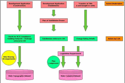
The topographic production process allows for the inclusion of data from external agencies. To streamline the process and prevent the duplication of effort, coordination at inter-agency level would be required. Once established at local government level, the inter-agency coordination would be used in a modified cadastral data integration process (refer figure 2), to allow for developments to be automatically available upon completion.
[image:8.595.82.513.372.658.2]This would also allow for road corridors that are named on a new deposited plan, to be placed in the cadastral fabric with the creation of the subdivision. These would then be added to the topographic road network at the start of the development.
CONCLUSIONS
The recently undertaken study focused on the aspects of data sharing and how those who participate in a data sharing program may be involved in the production of topographic maps through the provision of incremental updates. As this updated information becomes available, customers would have access to on demand mapping services that would ultimately enable relevant, up to date maps and map related data to enter society. Additional savings to government are also apparent through the elimination of effort required to maintain duplicate data sets.
Up to date topographic maps and data can be produced and maintained through the adoption of data sharing programs and arrangements, incremental updates, and through a modification of the present production and maintenance schedules. These modifications to the existing schedules would maximise the availability of contemporary products with the incrementally maintained data used in their production. Through the adoption of these individual production systems, the data used for map production would be constantly maintained. This allows for the printed topographic maps to contain information that is both temporally and spatially accurate at the time of production.
The system itself is not complicated. There needs to be a commitment from organisations, both public and private to recognise the benefits of contemporary spatial information, to be involved, and benefit from accessing accurate topographic maps. The system ultimately will provide data with the content and consistency that the mapping public desire within a desirable production timeframe using economic best practice. The change detection system was also shown to be suitable for spatial data output in the form of on demand topographic mapping as well as providing current information in a timely manner, which when implemented will improve temporal accuracy, aspatial attribution and spatial position.
The research has outlined a product and established a methodology that addresses the needs of geographic information customers. These requirements can be clearly categorised as consistent, complete, current, and correct. The “Now Map” will provide not only these but also specialised topographic data and map related products as well.
REFERENCES
Beyen, J & Henrion, J (1998), “Updating Topographic Databases with Arc Info: Client Fitted Creation of Change Only Information”, IAPRS, vol. 32, no. 4, pp. 59-64.
Brand, M (1998), “Digital Earth: The Issues”, Proceedings of AURISA 1998, AURISA.
Coleman, DJ (2000), “Collaborative Approaches to Building a Canadian Spatial Data Infrastructure”, Proceedings of
the 2000 Cambridge Conference, Cambridge, United Kingdom.
Dangermond, J (1999), “The Future Favours GIS”, Proceedings of AURISA 1999 (CD), AURISA.
Effenberg, WW & Williamson, IP (1996), Data Flows, Standards and Incremental Cadastral Update,
http://www.sli.unimelb.edu.au/research/publications/IPW/sirc96nocol.html, Web site accessed 08 June 2003.
Gan, E & Shi, W (2000), “Minimising the impact of inappropriate use of spatial data: Hong Kong”s Base Map”, GIM International, vol. 14, no. 5, pp. 44-47.
Grant, D (2000), “Geomatics Networking - Credo nos in fluctu eodem esse”, Proceedings of the 2000 Cambridge
Conference, Cambridge, United Kingdom.
Hardy, P & Woodsford, P (2000), “Incremental Updating using the gothic versioned object database with the hydrographic S57 ENC and SOTF spatial object transfer formats”, ICA/ISPRS 2000 Workshop on
Incremental Updating and Versioning of Spatial Databases, Amsterdam.
Hong Kong Government (2002), Topographic Survey, http://www.gov.hk/landsd/mapping/sub/ts/ts_m.htm, Web site accessed 27 June 2003.
ICSM (2003), Harmonised Data Manual - Policy and Guidelines for Incremental Update,
Jacoby, S & Marwick, B (1997), “A new era for Victoria’s digital cadastral database”, Proceedings of AURISA 1997, AURISA.
McRae, R & Walker, A (2000), “Community Mapping - an aid to emergency management”, Australian Journal of
Emergency Management, vol. 15, no. 4, pp. 22-27.
Nairn, A & Holland, P (2000), The NGDI of Australia - Achievements and Challenges from a Federal Perspective,
http://www.gisdevelopment.net/policy/international/interna007pf.htm, Web site accessed 08 June 2003.
Polley, I, Williamson, I & Effenberg, W (1997), “Suitability of internet technologies for access, transmission and updating of digital cadastral databases on the www”, Proceedings of AURISA 1997, AURISA.
Rhind, D (1995), Spatial Databases and Information Policy: A British Perspective,
http://www.spatial.maine.edu/tempe/rhind.html, Web site accessed 28 November 2004.
Ryttersgaard, J (1998), “Elements in the Danish Approach to a National Spatial Data Infrastructure”, FIG Commission 3 & 7 Newsletter - February 1998, no. 17, pp. 10-12.
Sorensen, M (2000), “Institutional Linkages for National and Regional GIS - Management Issues, Opportunities and Challenges”, Proceedings of the 2000 Cambridge Conference, Cambridge, United Kingdom.
Veenendaal, B, Taylor, M & Gahegan, M (1997), “Geographic Information: Access, Access and Access”, Proceedings
![Table 1: A broad overview of the responsibilities of the various levels of government in Australia [Nairn & Holland 2000]](https://thumb-us.123doks.com/thumbv2/123dok_us/319184.63940/2.595.107.488.651.724/table-overview-responsibilities-various-levels-government-australia-holland.webp)