University of Southern Queensland
Faculty of Engineering and Surveying
The implications regional ecosystem mapping has on
land development proposals in rural Queensland
A dissertation submitted by
Michael Peter Day
in fulfilment of the requirements of
Courses ENG4111 and 4112 Research Project
towards the degree of
Bachelor of Spatial Science (Surveying)
Abstract
Over the past 13 years there have been major changes in legislation that have
impacted on the land development process in Queensland. It has now become difficult
for the average person to undertake land development particularly in rural Queensland.
Many people considering undertaking such a project are unaware of the complexity of
the legislation and the requirements necessary to complete a land development project.
This dissertation has simulated the land development process in rural Queensland at
times of significant legislative change. This was carried out by using a parcel of land
as a case study. The method involved using this parcel of land to simulate a lot
reconfiguration. The simulation was carried out to coincide with significant changes
in legislation. This simulation process focused on the requirements that were
necessary to undertake and successfully complete a lot reconfiguration. Other site
dependant variables have been assessed including the effects that trigger the
Vegetation Management Act 1999
(VMA).
After detailed research and analysis it was concluded that attempting land
development in areas that contain assessable vegetation is a major constraint on the
viability of the project. The research analyses how the remnant vegetation and
regional ecosystem mapping was undertaken and reveals the errors that have occurred
and the uncertainty that still exists. The results illustrate the changes that have taken
place in the land development process over the past 13 years. The results also
highlight the difficulties and complexities that are encountered when attempting to
proceed with such a project.
University of Southern Queensland
Faculty of Engineering and Surveying
ENG4111 & ENG4112 Research Project
Limitations of Use
The Council of the University of Southern Queensland, its Faculty of Engineering and
Surveying, and the staff of the University of Southern Queensland, do not accept any
responsibility for the truth, accuracy or completeness of material contained within or
associated with this dissertation.
Persons using all or any part of this material do so at their own risk, and not at the risk
of the Council of the University of Southern Queensland, its Faculty of Engineering
and Surveying or the staff of the University of Southern Queensland.
This dissertation reports an educational exercise and has no purpose or validity
beyond this exercise. The sole purpose of the course pair entitled “Research Project”
is to contribute to the overall education within the student’s chosen degree program.
This document, the associated hardware, software, drawings, and other material set
out in the associated appendices should not be used for any other purpose: if they are
so used, it is entirely at the risk of the user.
Prof Frank Bullen
Dean
Certification
I certify that the ideas, designs and experimental work, results, analyses and
conclusions set out in this dissertation are entirely my own effort, except where
otherwise indicated and acknowledged.
I further certify that the work is original and has not been previously submitted for
assessment in any other course or institution, except where specifically stated.
Michael Peter Day
Student Number: 0050071719
………
Signature
Acknowledgements
I would like to thank my supervisor A/Prof. Kevin McDougall for his guidance and
support throughout this project. I would like to thank Mr Shawn Darr for his help with
the initial idea and development for this project.
TABLE OF CONTENTS
Contents
Page
ABSTRACT
i
DISCLAIMERS
ii
CANDIDATES CERTIFICATION
iii
ACKNOWLEDGEMENTS
iv
LIST OF FIGURES
ix
LIST OF TABLES
x
LIST OF APPENDICES
xi
ABBREVIATIONS
xii
CHAPTER 1 - INTRODUCTION
1.1
Project
Background
1
1.2
Research
Aim
3
1.3
Research
Objectives
3
1.4
Justification
4
1.5
Conclusion
5
CHAPTER 2 - LITERATURE REVIEW
2.1
Introduction
7
2.2
Background
Information
7
2.3
Integrated
Planning
Act
1997
8
2.4
Vegetation
Management
Act
1999
10
2.5
Remnant Vegetation and Regional
Ecosystem
Mapping
12
2.6
Sustainable
Planning
Act
2009 14
2.7
Impact
on
Cadastral
Surveying 15
CHAPTER 3 - METHODOLOGY
3.1
Introduction
17
3.2
Site
Location
17
3.3
Legislation
18
3.4
Local Government (Planning and Environment) Act
1990
19
3.5
Integrated
Planning
Act
1997
19
3.6
Integrated Development Assessment System
19
3.7
Vegetation Management Act 1999
20
3.8
Sustainable Planning Act 2009
20
3.9
Land development process before the proclamation
of the Vegetation Management Act 1999
21
3.10
Land development process after the proclamation
of the Vegetation Management Act 1999
21
3.11 Land development process after the proclamation
of the Sustainable Planning Act 2009
22
3.12
Remnant Vegetation and Regional Ecosystem
Mapping
22
3.13
Land
clearing
Rates
24
3.14
Conclusion
24
CHAPTER 4 - RESEARCH AND ANALYSIS
4.1
Introduction
25
4.2
Local Government (Planning & Environment) Act
1990
25
4.3
Integrated
Planning
Act
1997
28
4.4
Integrated Development Assessment System
31
4.4.1 Application Stage
34
4.4.2 Information and Referral Stage
35
4.4.3 Notification Stage
36
4.4.4 Decision Stage
37
4.5
Vegetation
Management
Act
1999
38
4.5.3 Reconfiguring a Lot
41
4.6
Sustainable
Planning
Act
2009 42
4.7
Land Development Process before the Proclamation
of the Vegetation Management Act 1999
47
4.7.1 Application Submission
47
4.7.2 Application Assessment
48
4.7.3 Information and Referral
49
4.7.4 Application Decision
49
4.8
Land
Development
Process after the Proclamation
of the Vegetation Management Act 1999
50
4.8.1 Application Submission
50
4.8.2 Application Assessment
51
4.8.3 Information and Referral
52
4.8.4 Application Decision
53
4.9
Land
Development
Process after the Proclamation
of the Sustainable Planning Act 1999
53
4.9.1 Application Submission
54
4.9.2 Application Assessment
54
4.9.3 Information and Referral
55
4.9.5 Application Decision
56
4.10
Remnant Vegetation & Regional Ecosystem
Mapping
56
4.10.13 Reference Sites
74
4.10.14 Regional Ecosystem & Remnant Maps
75
4.10.15 Heterogeneous polygons
75
4.11
Land
Clearing
Rates
77
4.12
Conclusion
77
CHAPTER 5 - RESULTS AND DISCUSSION
5.1
Introduction
79
5.2
Legislation
79
5.3
Comparison across Evolving Legislation
82
5.3.1 Application Submission
82
5.3.2 Application Assessment
84
5.3.3 Information and Referral
85
5.3.4 Application Decision
87
5.4
Land
Clearing
Rates
88
5.5
Remnant Vegetation and Regional Ecosystem
Mapping
88
5.5.1 Essential Habitat Mapping
90
5.6
Land
Development
Impediments
91
5.6.1 Regional Vegetation Management Code for
New England Tablelands Bioregion
91
5.6.2 Guide for Local Governments and Applicants
Implementing MCU/RaL Triggers
92
5.6.3 Property Maps of Assessable Vegetation
92
5.7
Conclusion
93
CHAPTER 6 – CONCLUSIONS AND RECOMMENDATIONS
6.1
Introduction
95
6.2
Key
Findings
95
6.3
Further Research and Recommendations
96
6.4
Limitations
of
the
Study
97
6.5
Close
98
LIST OF FIGURES
Number
Title
Page
3.1
Locality
Map
18
4.1
Assessable
Development
31
4.2
Types
of
Development 32
4.3
The
IDAS
Process
33
4.4
Bioregion
Map
of
Queensland 58
4.5
Areas of Essential Habitat and Recorded Sightings
62
4.6
Regional
Ecosystem
Map
64
4.7
Aerial Photography of the Ballandean Region
71
LIST OF TABLES
Number
Title
Page
4.1
PMAV
Categories
66
LIST OF APPENDICES
Number
Title
Page
A
Project
Specification
104
B
Smart
Map
105
C
Cadastral
Plans 106
D
Remnant Vegetation and Regional Ecosystem Map
108
E
Remnant Vegetation and Essential Habitat Map
109
F
Section 22A of the Vegetation Management Act 1999
110
G
Schedule 8 of the Integrated Planning Act 1997
111
H
Application for Land Development before the Proclamation
of the Vegetation Management Act 1999
113
H1
Proposed Plan of Lot Reconfiguration
115
I
Application for Land Development after the Proclamation
of the Vegetation Management Act 1999
116
I1
Proposed Plan of Lot Reconfiguration
122
J
Regional Vegetation Management Code for the Brigalow
Belt and New England Tablelands Bioregions
123
K
Application for Land Development after the Proclamation
of the Sustainable Planning Act 1999
128
L
Regional Vegetation Management Code for the Brigalow
ABBREVIATIONS
The following abbreviations have been used throughout the text:-
ACRES
Australian Centre for Remote Sensing
DERM
Department of Environment and Resource Management
GDA94
Geocentric Datum of Australia 1994
GIS
Geographic
Information
System
IDAS
Integrated Development Assessment System
IPA
Integrated Planning Act 1997
LGPEA
Local Government (Planning and Environment) Act 1990
PMAV
Property Map of Assessable Vegetation
REDD
Regional
Ecosystem Description Database
SDRC
Southern Downs Regional Council
SPA
Sustainable
Planning
Act
2009
SPB
Sustainable
Planning
Bill
2009
SPR
Sustainable
Planning
Regulation
2009
SSCPS
Stanthorpe
Shire
Council
Planning
Scheme
SSPs
State
Planning
Policies
SLATS
State-Wide Land Cover and Trees Study
UTM
Universal
Transverse
Mercator
VMA
Vegetation Management Act 1999
Chapter 1: Introduction
1.1
Project Background
This project will involve simulating a lot reconfiguration of a parcel of land situated near Ballandean 25 kilometres south of Stanthorpe. The subject parcel of land is one of a number of freehold titles held under the ownership of a property known as ‘Amaroo’. The size of the lot is 15 hectares. The property description is Lot 1 on RP91867, parish of Broadwater, county of Bentinck. This parcel of land is a mix of good quality agricultural land, steep rocky outcrops of granite and heavily timbered bushland.
In undertaking this exercise it was identified that the protection of the good quality agricultural land was extremely important. Small parcels of land in the Stanthorpe region are sought after and are in very short supply. These ‘lifestyle’ blocks are popular escapes for people from large urban centres. Potential purchasers of this type of real estate are predominately interested in small land parcels consisting of natural bushland.
Over the past 13 years there have been significant legislative changes in the development of land in Queensland. The aim of this project is to compare the outcome of this land development proposal at these times of significant legislative change. An in depth analysis of the land development process at each of these points in time will given by using Lot 1 on RP91867 as a case study.
Before the introduction of the IPA, development proposals were assessed under local government planning schemes that were written in accordance with the Local Government (Planning and Environment) Act 1990 (LGPEA). These planning schemes were based on a prescriptive approach. This type of system regulated development. The introduction of the IPA resulted in major changes to the land development process. The IPA together with the introduction of the Integrated Development Assessment System (IDAS) sought to implement a single administrative framework for property development applications (USQ 2009). This new act repealed a multitude of other Acts that required approval for development applications. The purpose of the IDAS was to incorporate a myriad of assessment and approval systems into one streamlined process (USQ 2009).
In 1999 the requirements for land development proposals in rural Queensland underwent further change. The proclamation of the VMA saw significant restrictions placed on the way land development was conducted. The purpose of this legislation was to reduce the clearing and destruction of Queensland’s native vegetation. It regulates the clearing of remnant vegetation on freehold land, indigenous land and other state tenures (Department of Environment and Resource Management 2010). The VMA sets down the rules and regulations that guide what clearing can be done. This framework is made up of legislation, state policy, regional vegetation management codes, an offsets policy, a regrowth vegetation code, material change of use policy and reconfiguring a lot policy (Department of Environment and Resource Management 2010). Vegetation management in Queensland is regulated through the VMA and the IPA.
This project will focus on the implications the VMA and subsequent regional ecosystem mapping has on land development proposals in rural Queensland. A significant component of this project will involve researching and analysing how this mapping was carried out to determine accuracy and fairness. The recently enacted SPA is likely to impact on land development proposals in Queensland. Despite this only being new legislation, this project will analyse this Act and attempt to determine the implications that may occur.
1.2
Research Aim
This project will seek to compare the outcome of a land development proposal at times of significant legislative changes in Queensland.
1.3
Research Objectives
The objectives of the project are as follows:
- Evaluate the land development process in rural areas of Queensland before and after the VMA was implemented
- Research how and why the VMA came into force
- Evaluate how regional ecosystem mapping was carried out and critically analyse the limitations of this mapping to determine accuracy and credibility
- Evaluate land development restrictions by using a parcel of land near Stanthorpe as a case study
- Critically analyse the impact that the VMA has made on cadastral surveying
1.4
Justification
Several years ago an attempt was made to undertake a lot reconfiguration. With a limited supply of lifestyle type property available in the area, and a significant amount of unusable natural bushland close by, it became evident that undertaking a lot reconfiguration would be a good business decision. It was planned to use the existing title of Lot 1 on RP91867 as the parcel of land to be reconfigured. The balance of Lot 1 on RP91867 will be added to Lot 131 on BNT 458. A Smart Map and cadastral plans of these two parcels of land are located in Appendix B and C respectively. This development proposal does not involve creating any additional lots.
The total area of the proposed lot would be four hectares. The reconfigured lot would consist primarily of natural bushland. This would be a mix of steep rocky granite outcrops and undulating heavily timbered areas. The remaining area would be made up of approximately 5000m² of open arable land. Adding to the attractiveness of the proposed lot is a number of potential home sites that offer excellent views and numerous other sustainability features. These include aspect to the north and protection from cold prevailing winter winds from the south-west.
Adding the balance area of Lot 1 on RP91867 to Lot 131 on BNT458 will ensure that the good quality agricultural land is protected. Lot 131 on BNT458 is a much larger block consisting of 94.2 hectares. This area consists of some valuable agricultural land and a large portion of steep, rugged and heavily timbered terrain. This parcel of land is bounded to the south by Bald Rock Creek.
number of lots it made good business sense to undertake a land development project.
After the proclamation of the VMA in 1999 and the subsequent remnant vegetation and regional ecosystem mapping that this Act guided, developing land in rural areas became much more difficult. A major constraint on the viability of this project is the VMA that is triggered when attempting to develop land in areas that have been mapped as assessable vegetation. The IPA and SPA are large and complex pieces of legislation and when land development applications trigger the VMA, complexity and uncertainty increases significantly.
Developing land in areas that contain assessable vegetation has almost become too complex for the average person to contemplate. Many rural landholders are unaware of the status of the vegetation on their properties and the limitations of the changing legislation. This project will attempt to highlight the changes that have taken place for land development proposals in rural Queensland over the past 13 years. This analysis of legislation will simplify the processes and highlight limitations that occur during a land development proposal. Once this is more easily understood rural landholders may be in a position to take advantage of their current resources.
1.5
Conclusion
Chapter 2: Literature Review
2.1 Introduction
The land development process in Queensland has witnessed some major changes over the past 13 years. This process is continuing to evolve with the recent enactment of the SPA on 18 December 2009. The information sourced for this literature review will come from a wide range of sources. These include student papers, academic papers, university study material, journal articles, government departments, reviews from professionals and communication with professionals working in the industry. Due to the complex nature of the relevant legislation that this project will cover, there is minimal quality control on the content of this project. Research on this project has uncovered many conflicting opinions on land development legislation. This literature review will attempt to assess the material that was researched and evaluate its relationship to the project topic.
2.2 Background Information
In order to achieve the aim of this project, an understanding of the IPA is needed. Since the introduction of this legislation the land development process has become very complex and confusing. Local government authorities in Queensland are responsible for the formulation and subsequent administration of their planning schemes. These documents are often complicated making land development applications difficult. If the application is impact assessable the time taken to process the application can take up to 9 – 12 months (Ireland 2008). This is assuming there are no appeals and the local authority has been cooperative. The costs imposed on the applicant are significant.
(2008) goes on to say that it is important that the application is not only given consideration to the laws and policies applying when the application was lodged but also to the new laws and policies that have come into force after the application was lodged. This paper exposed some of the unforeseen difficulties that developers encounter. It also highlighted just how complex and expensive even a relatively simple development proposal can become.
This view is shared by Steve Reynolds of Humphreys Reynolds Perkins Planning Consultants. Reynolds claims that there is a planning crisis in Queensland. He says that the development approvals system under the IPA is complex, costly and time consuming (Reynolds 2007). Reynolds (2007) also states that the outcomes being achieved through the development assessment system are mediocre. He claims the reason for this is the combination of two factors. These are the quality and organisational culture of local government development assessment and the structure and complexity of the planning system (Reynolds 2007). These comments are concerning as development is being stifled because of bureaucracy. This paper will be a valuable resource in assessing the implications for the land development process in rural Queensland.
2.3 Integrated Planning Act 1997
With all due respect to the IPA and local government planning schemes that have been developed as a requirement of the Act, both the legislation and planning schemes are complicated and ambiguous. Critics of the IPA such as Dr Phil Day have said ‘Let’s toss the IPA and start from scratch’. Day claims that planning legislation should not appear to be so complex and technical that planning decisions are left to the unelected officers (Day 2006). He goes on to say that blueprint planning schemes are illusory goals that after years of preparation can became obsolete within days because of economic or social changes (Day 2006). Day (2006) says that the development assessment codes in the IPA are contrived, complex and confusing.
Day (2006) claims that councils used a commonsense approach when preparing plans and assessing development under the previous system. He also says that time and money could be saved by preventing appeals going to court because of the absurdly detailed procedural provisions of the IPA (Day 2006). Researching this topic has uncovered valuable material and has identified the difficulties that developers will encounter. This paper will be very useful in completing this project.
2.4 Vegetation Management Act 1999
Vegetation Management in Queensland has been a very controversial issue. The VMA itself does not regulate vegetation management (McGrath 2006). The VMA guides the preparation of mapping for areas to be protected. This includes areas of high conservation value, areas susceptible to land degradation and remnant vegetation (McGrath 2006). Major reforms to the Act were introduced in 2004 due to ongoing controversy. These reforms involved phasing out broad scale land clearing by the end of 2006 (McGrath 2006). The VMA outlines the policies for clearing vegetation. The triggers and process for assessment for clearing vegetation is contained in the IPA(McGrath 2006). A reconfiguration of a lot will potentially lead to clearing so additional triggers will apply.
According to Suri Ratnapala (2004) the VMA establishes an undemocratic form of law-making affecting property rights in the State. He claims that the Act does not make the law but leaves legislative power in the hands of the Minister and executive officers to be exercised outside the parliamentary process (Ratnapala 2004). Ratnapala (2004) goes on to say that the process is structurally biased and insulated from the glare of public debate. There is no appeal from this law to parliament or to the courts (Ratnapala 2004). This has major repercussions for property owners. Landholders must manage their properties in accordance with the declared area code (Ratnapala 2004). This has increased operational costs and reduced productivity resulting in loss of income (Ratnapala 2004). More critically, it will reduce the market value of the property. Many landholders have been disadvantaged and are not entitled to compensation. This paper will be an essential resource for the duration of this project.
grazing enterprises will become unviable. This will ultimately impact on the economies of rural communities.
Burrows (2005) is also concerned that unaddressed tree thickening poses a major fire risk in the future. Burrows (2005) believes that the framing of the Act and its regulations deliberately and capriciously ignored a large body of scientific research and economic data relevant to the management of vegetation on our grazing lands (Burrows 2005). The opinions put forward by Burrows must be respected as he worked as a research scientist for 40 years. Burrows view is interesting and his thoughts will be considered during the preparation of this project.
A paper by Lyons & Whelan (2004) claim that in recent years clearing is estimated to be occurring at a rate of around half a million hectares each year. This habitat destruction is linked to biodiversity loss, climate change, and increased salinity (Lyons & Whelan 2004). Despite recognition of these environmental problems, land clearing was still allowed to continue. They said that priority was given to short-term economic growth above ecological and social considerations (Lyons & Whelan 2004). It is stated that these attitudes have shaped the history of natural resource management (Lyons & Whelan 2004).
Lyons & Whelan (2004) go on to say that the decision to stop clearing of remnant vegetation by 2006 is a victory for the conservation movement. This displays a significant change of policy that assumes private landowners retain sovereignty over land management (Lyons & Whelan 2004). This highlights the strength of the conservation movement in Queensland. This paper will be used as part of this project. Resources such as these are necessary to ensure the research is conducted in an objective manner.
(Wildlife Preservation Society of Queensland 2004). The WPSQ (2004) state that land owners have a duty of care for management of their land and expect that the costs associated with this should be met by the landholder. The society requested that the legislation must apply to all land users and not just the rural sector and limited urban/rural enterprises (Wildlife Preservation Society of Queensland 2004). Some of these requests have merit but expecting land holders to adopt conservation practices at their own cost is unrealistic. Despite this, the opinions of WPSQ will provide a valuable contribution towards finalising this project.
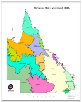
2.5 Remnant Vegetation and Regional Ecosystem Mapping
The system used for classifying vegetation under the VMAis known as regional ecosystems. Queensland has been divided into 13 bioregions which are based on numerous factors (Department of Environment and Resource Management 2010). Regional ecosystems are vegetation communities associated with particular landforms within each bioregion (McGrath 2006). Maps depicting these regional ecosystems show the remnant vegetation that remains. McGrath (2006) recognises that this system has limitations. He claims that it is a robust surrogate for planning the conservation of both the known and unknown elements of biodiversity (McGrath 2006). McGrath (2006) admits that the system is not a good surrogate for all species, and does not necessarily address the conservation needs of many rare and threatened species. A valid and very important point noted by McGrath (2006) is that the regional ecosystem protects remnant vegetation communities regardless of their attractiveness and aesthetic value.
regional ecosystem mapping also need to be questioned. If there are gross inaccuracies contained in the mapping and dubious boundaries in other areas how can a landholder have faith in the system? Much of this mapping has been completed at a scale of 1:100,000 (Department of Environment and Resource Management 2010). The achievable accuracies and fairness at this scale must be rigorously questioned. This regional ecosystem mapping will make up a major component of this project.
Forest & Sea Consulting (2010) have said that the Queensland Government’s vegetation mapping system is an ambitious project that covers an area that is bigger than most of the world’s countries. They claim that some of the situations that they have encountered are difficult to understand (Forest & Sea Consulting 2010). These include determining which regional ecosystem is present from a list of extremely similar regional ecosystems, vegetation that does not fit any regional ecosystem description, vegetation which does not fit any of the regional ecosystems listed for an area and determining whether vegetation is remnant or non-remnant (Forest & Sea Consulting 2010). These claims are very interesting and support the view that there are serious issues about the credibility of the mapping. This resource will be used extensively during the research phase of the project.
An editorial by McAlpine, Fensham & McIntyre (2002) and published in the Rangeland Journal states that some authors have argued that a higher percentage of native vegetation should be retained in bioregions. The retention rate is currently set at 30% but there are claims that this may not adequately protect all bioregions (McAlpine, Fensham & McIntyre 2002). They say that bioregions that have large areas of native vegetation that are in marginal areas for agricultural development are at real risk of losing significant amounts of biodiversity (McAlpine, Fensham & McIntyre 2002).
outcomes. While this author’s concerns about loss of biodiversity in marginal areas are important, it is unlikely that large scale destruction would occur in these areas. This can be attributed to the huge costs involved and the poor returns that can be expected. McAlpine, Fensham & McIntyre raise other interesting points that will be considered.
2.6 Sustainable Planning Act 2009
The SPA was proclaimed on 18 December 2009. The purpose of this Act is to replace the IPA. As this Act has only recently come into force it is difficult to determine the implications of this new legislation. The SPA has been designed to streamline planning schemes and focus on outcomes rather than be process driven as was the case with IPA.
According to a paper on the Sustainable Planning Bill 2009 (SPB) by David Nicholls (2009) there are some welcome changes, but there are other changes that are not so welcome. Nicholls (2009) claims that under the Act referral agencies will be required to assess applications against State Planning Regulatory Provisions and State Planning Policies (SPPs) that are not applied by the referral agency. These are areas that the agency does not usually administer and is likely to cause confusion (Nicholls 2009).
process. Although this paper is relatively complex, it will be an invaluable resource during this project.
2.7 Impact on Cadastral Surveying
Although the VMA and subsequent regional ecosystem mapping has been a very controversial issue in rural Queensland very little information is available from a surveying perspective. Despite exhaustive research very little literature has been uncovered on how cadastral surveying has been impacted. This impact will be difficult to quantify. Acquiring further knowledge in this area is important as it is becoming increasingly obvious that future development and prosperity in rural communities could be compromised as a result of the evolving legislation.
2.8 Conclusion
This review has identified the problems in the legislation that have plagued the land development process in Queensland. The land development process in Queensland has now become a complex and expensive process. Although the recent legislation places great emphasis on the protection of biodiversity, the development process is becoming more and more constrained by bureaucracy and red tape.
Chapter 3: Methodology
3.1 Introduction
Over the past 13 years there have been significant legislative changes for the development of land in Queensland. As a result, lot reconfigurations in rural Queensland are becoming increasingly difficult. An in depth analysis of the land development process at significant points in time will be undertaken by using Lot 1 on RP91867 as a case study. This project will also focus on remnant vegetation and regional ecosystem mapping. This will require an extensive knowledge of the relevant concepts in this area. The research component of this project was carried out using the structure as follows.
3.2 Site Location
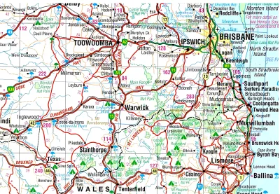
Figure 3.1: Locality map (Source: Hema Maps Australia, 2007)
3.3 Legislation
3.4 Local Government (Planning and Environment) Act 1990
Before the introduction of the IPA, development proposals were assessed under local government planning schemes that were written in accordance with the LGPEA. Under this system a development proposal needed to satisfy a number of development approvals across different systems (USQ 2009). There was no integration between the various systems. This led to many problems for developers. The land development process will be analysed under this system. This will include the processes that had to be followed, the expected time periods for approvals to be granted and the costs involved.
3.5 Integrated Planning Act 1997
The introduction of the IPA resulted in major changes to the land development process. This new Act replaced numerous other pieces of legislation in an attempt to streamline land development. The IPA was implemented with the major purpose to ‘seek to achieve ecological sustainability’ (USQ 2009). The IPA will be analysed to demonstrate the land development process during the period from the proclamation of the VMA to the proclamation of the SPA. This information will be derived from a number of sources in the particular, the IPA. The analysis of this legislation will reveal significant changes that have taken place.
3.6 Integrated Development Assessment System
activity. Under the IDAS systems there is usually only one agency that has to be contacted for development applications. This is important as it has allowed for common time frames, procedures and appeal mechanisms. An in-depth explanation of the IDAS process will be presented and applied to the land development process. Each stage of the IDAS process will be analysed to provide a clear understanding of the system. This will be achieved through simulating a land development proposal.
3.7 Vegetation Management Act 1999
The VMA has been a very controversial issue particularly in rural Queensland. The purpose of this legislation was to reduce the clearing and destruction of Queensland’s native vegetation. This legislation has significantly impacted on many rural landholders. This impact has been felt in both land development proposals and ongoing land management.
The VMA sets down the rules and regulations that guide what clearing can be carried out. This project will involve analysing the vegetation management framework. This includes an analysis of the legislation, state policy for vegetation management, regional vegetation management codes and the reconfiguring a lot policy. The VMA comprises a large part of this project and as a result a thorough explanation of this legislative framework will be presented. A detailed knowledge is necessary to understand the complexity of the vegetation management framework. This data will be sourced from the Department of Environment and Resource Management (DERM). The data presented will be made up of legislation, publications, fact sheets, maps and images.
3.8 Sustainable Planning Act 2009
developers. The Act was proclaimed on 18 December 2009 and replaces the IPA. As with the IPA, the SPA contains the triggers for the VMA. The major changes to this new legislation will be analysed particularly the changes that affect rural land development. These changes will be noted and applied to a simulated land development proposal.
3.9 Land Development Process before the Proclamation of the
Vegetation Management Act 1999
The land development process before the VMA required approval from numerous sources before development could proceed. There was little or no integration between each of the systems which to many difficulties. This system will be analysed by applying the legislative and local government planning scheme requirements to undertake a rural lot reconfiguration. The requirements of the Stanthorpe Shire Council Planning Scheme (SSCPS) from 1996 will be analysed and applied to the development process in conjunction with the LGPEA. The outcome of this process will be compared to the subsequent legislative changes. The mechanism for comparison will involve the following four stages:
- Application submission - Application assessment - Information and referral - Application Decision.
3.10 Land Development Process after the Proclamation of the
Vegetation Management Act 1999
referred to the DERM. A land development proposal will be analysed and then compared to processes before and after this legislation was enforced. The same mechanism for comparison will be used for each legislative period. As the focus of this project is on the VMA, the local government requirements will not be considered.
3.11 Land Development Process after the Proclamation of the
Sustainable Planning Act 2009
The SPA has only been in force for a relatively short period of time. It is anticipated that this legislation will deliver a range of benefits to developers. The IDAS process has been retained in the Act with a new compliance stage added. Other changes have been made which may affect a development proposal. This new legislation will be analysed with the purpose to compare the changes and benefits of the land development process across the evolving legislation. The same mechanism of comparison will be followed to enable meaningful analysis and judgements to be made. As with the previous legislative time period no analysis of the local government planning scheme requirements will be presented.
3.12 Remnant Vegetation and Regional Ecosystem Mapping
vegetation. This was subsequently assigned a conservation status and classified into region ecosystems.
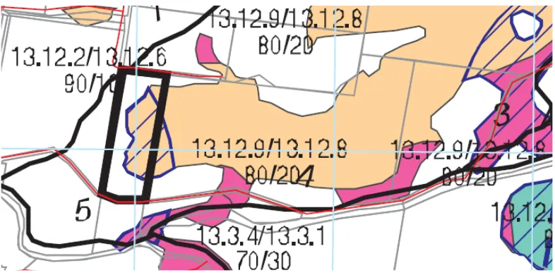
Serious concerns about the mapping were raised when agricultural areas that had been used for grapes and vegetables for over 60 years had been classified as endangered regional ecosystems. This is highlighted on the map in Appendix E. This project has set out to investigate how this mapping was conducted and the accuracy and fairness of this process. In order to achieve this, a thorough analysis of the techniques and methodology used by the Queensland Herbarium will be necessary. This information has been compiled and presented under the following headings:
- Vegetation Mapping Framework
- Conservation Status of Regional Ecosystems - Essential Habitat
- Interpreting Regional Ecosystem Maps - Property Maps of Assessable Vegetation
- Surveying and Mapping of Regional Ecosystems - Pre-clearing Vegetation
- Pre-clearing Mapping Methods - Interpretation of Aerial Photographs - Remnant Vegetation Cover
- Landsat Imagery
- Remnant Vegetation Mapping Methods - Reference Sites
- Regional Ecosystem and Remnant Maps - Heterogeneous Polygons.
3.13 Land Clearing Rates
This project will involve brief research into the land clearing rates that have occurred under the changing legislation. Data that has been sourced from the DERM will reveal the dramatic reduction in land clearing as a result of the VMA.
3.14 Conclusion
This chapter describes the process and techniques that were used for this project. It has defined the site location for the analysis of the proposed lot reconfiguration. The mechanism for comparison of legislation when lodging a land development proposal has been outlined. The procedures and necessary requirements relevant to the legislation at the time will be analysed. Research will be carried out to provide a clear understanding of how and why vegetation management legislation was put in place. This chapter contains an outline of how the analysis of vegetation management mapping process and methods will be carried out.
Chapter 4: Research and Analysis
4.1 Introduction
This chapter will present the research and analysis of a simulated development proposal at three significant time periods. It will provide a detailed analysis of the legislation that is triggered when a lot reconfiguration is undertaken. A significant portion of this chapter involves research and analysis of the remnant vegetation and regional ecosystem mapping that has been carried out. A number of pictures and diagrams have been used in this chapter.
The purpose of this chapter is to provide readers with much clearer understanding of the processes and barriers that occur when considering a land development project in rural areas of Queensland. It is anticipated that this will assist developers in making more informed choices when deciding to invest in these types of projects. The analysis presented in this chapter highlight the changes that have taken place as a result of the evolving legislation. This chapter will identify the challenges and constraints that rural landholders are now forced to accept.
4.2
Local Government (Planning and Environment) Act 1990
Before the introduction of the IPA and the VMA land development applications were assessed under the relevant local government planning schemes. These planning schemes were written and prepared in accordance with the LGPEA. These planning schemes were based on a prescriptive approach (USQ 2009). This type of system regulated development. This LGPEA set out the components that a planning scheme must consist of. These were:
- Provisions for the regulation, implementation and administration of the Planning Scheme
- A Development Control Plan
- Any amendment approved by the governor in council in respect of the planning scheme (USQ 2009).
These planning schemes operated under a hierarchical system. This was a requirement of the Act. An example of this is the Strategic Plan of the local government authority. Strategic Plans are necessary for long term planning and cover a broad range. Below the strategic plan in the order of hierarchy were development controls plans and following this was the zoning of the local government area (USQ 2009). Under this system, Strategic Plans were central to the planning scheme. The Act at this time also set out the requirements of a Strategic Plan. These included:
- Maps delineating preferred land use
- A statement of objectives for each of the land uses as well as criteria to outline the type, scale and distribution of other uses required as an integral component to service each preferred dominant land use - Criteria outlining how the plan will be implemented (USQ 2009).
Lower down in the hierarchy are the Development Control Plans followed by the zones. Development Control Plans are made up of maps, statements of intent and criteria for implementation. The Development Control Plans are designed to serve a number of functions. These are:
- To guide the orderly growth and development of the area - To coordinate the design and layout of transportation - To ensure town planning problems could be solved
- Ensure effective implementation of the planning scheme (USQ 2009).
The land development process under the LGPEA had no real requirements except those that were imposed by the respective local government authorities. These requirements were set out in the local government planning scheme. Applications for land development were only dealt with by council (Davis, J 2010, per. comm., 15 August). Under the legislation at the time there were no referrals that were required to be lodged with other government departments or other organisations.
The land development process involved submitting a development proposal to the council. This application would be assessed against the planning scheme put in place by the local authority. Planning schemes written under the legislation at the time used a system of land uses that were regulated through zones. Planning schemes written under the LGPEA were permitted to prohibit or impose conditions on certain developments (USQ 2009). Under this legislation the process for making an application to develop land was set out by the Act. The Act contained assessment criteria that guided the land development process.
4.3
Integrated Planning Act 1997
From 1998 up until 18 December 2009 the IPA was the principle source of law for planning and development in Queensland. This Act was developed to process development applications. This act together with the introduction of the IDAS sought to implement a single administrative framework for property development applications (USQ 2009). This new act repealed the multitude of other Acts that required approval for development applications as previously stated in Chapter 1.
All local government authorities were required to develop planning schemes to process these applications. The IPA came into force on 30 March 1998. As the SSC planning scheme at the time had been prepared under the LGPEA it was automatically converted to a transitional planning scheme when the IPA took effect (USQ 2009). This allowed the planning scheme to be used for development applications under the IDAS. This arrangement expired on March 31 2003.
The introduction of the IPA also allowed the Queensland government to develop and enforce State Planning Policies (SPPs). These state planning policies then had to be implemented by local government authorities into their respective planning schemes (USQ 2009). Two State Planning Policies that are relevant to this proposal are SPP 1/92 - The development and conservation of agricultural land and, SPP 1/03 – Mitigating the adverse impacts of flood, bushfire and landslide.
of planning schemes developed under the preceding Act. This made planning schemes very difficult to write (Davis, J 2010, per. comm., 15 August).
The new Act was very different in that none of the components that were mandatory under the LGPEAwere required under the IPA. The result of this was that new planning schemes had a very broad range of structural options. The purpose of this was to allow local governments to recognise their own individual requirements for their particular area. Under the IPA local governments cannot simply prohibit a particular use of land or a type of development (McGrath 2006). This was of course on the condition that they would satisfy the conditions set out in the new Act. The IPA was implemented with the major purpose to ‘seek to achieve ecological sustainability’ (Queensland Government 2009). This can be found under section 1.2.1 of the Act. Ecological sustainability would be achieved by three interlocking factors. These are:
- Coordinating and integrating planning at the local, regional and state levels
- Managing the process by which development occurs
- Managing the effects of development on the environment (Queensland Government 2009).
The IPAdescribes ecological sustainability as a balance of ecological, economic and social/cultural interests. This purpose of ecological sustainability must be reflected in local government planning schemes. This can be achieved by local governments adopting a number of key principles when formulating their respective planning schemes (USQ 2009). The key principles are:
- The precautionary principle - Intergenerational equity
- Sustainable and prudent use of natural resources - Wise use of infrastructure investment
- Protection of biological diversity
Planning schemes normally have a forward planning timeframe of no more than 15 years. The IPA does stipulate that a review of the planning scheme must be undertaken every six years. It is not necessarily compulsory to make changes to the scheme after each review. If no changes are made a report must be submitted to the relevant government minister outlining the reasons for this outcome (USQ 2009). One of the major goals of the IPA was to integrate planning at a local level, a regional level and a state level. Local government authorities must not formulate their planning schemes in isolation from state and regional considerations (USQ 2009). This includes councils adopting state planning policies. Once a planning scheme has been put in place, councils cannot make amendments to the scheme until authorisation has been granted by the minister.
The structural requirements of a planning scheme are set out under section 2.1.3 of the IPA. This section stipulates the main components that must be present. These include:
- Identify the desired environmental outcomes for the local government area
- Include the measures that facilitate achievement of the desired environmental outcomes
- Include performance indicators to assess the achievement of the desired environmental outcomes (Queensland Government 2009).
4.4 Integrated
Development Assessment System
The purpose of the IDAS was to incorporate a myriad of assessment and approval systems into one streamlined process. The concept of development is central to the IDAS. Section 1.3.2 of the IPA defines development as any of the following:
- Carrying out building work
- Carrying out plumbing or drainage work
- Carrying out operational work
- Reconfiguring a lot
- Making a material change of use of premises (Queensland
Government 2009).
[image:44.612.186.488.551.617.2]Prior to the IPA a development proposal needed to satisfy a number of development approvals across different systems. Integration between the various systems was poor which led to many problems for developers. Although development under the IDAS is a broad term, it only requires approval if it is declared as assessable development. Development can be declared as assessable in two ways. This is displayed in Figure 4.1. Development can be declared as assessable by the state through Schedule 8 of the IPA and declared as assessable by a local government authority through their planning scheme (McGrath 2006). Schedule 8 is located in Appendix F.
Figure 4.1: Assessable Development (Source: USQ 2009)
development and self-assessable development do not need to become part of the IDAS system to proceed. An exempt development does not need approval from a planning scheme. Self-assessable development does not need official approval but the applicable codes within the planning scheme regarding the development must be complied with. Developments that are declared as ‘assessable development’ require a development application to be lodged through the IDAS system (USQ 2009). An assessable development can be either code assessable or impact assessable. This is represented in Figure 4.2.
Figure 4.2: Types of Development (Source: USQ 2009)
Code assessable and impact assessable development will trigger the IDAS process. A code assessable application will require development approval and must comply with the local government planning scheme and relevant codes. Public notification is not required for a code assessable application. Impact assessable developments also require development approval. Impact assessable developments are subject to a more stringent evaluation of the potential environmental effects of the proposal (USQ 2009). These development proposals must be publicly notified. This provides the general public with an opportunity to be informed of such development activity and an opportunity to lodge submissions.
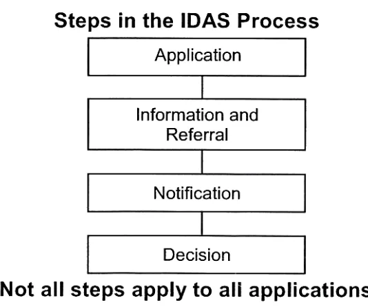
Figure 4.3: The IDAS Process (Source: USQ 2009)
The number of stages that are triggered will depend on the complexity of the development proposal. There are two main roles within the IDAS process. These are the assessment manager and the referral agency. In most cases the local government authority will manage the development application (McGrath 2006). This role is known as the assessment manager. The assessment manager has several responsibilities after receiving a development application. These responsibilities include issuing an acknowledgement notice if required, dealing with public submissions, dealing with referral agencies, assessing and deciding on the application and notifying the applicant of the outcome (USQ 2009).
considerably more powers than the advice agency. The powers of the concurrent agency include requesting more information from the applicant regarding a proposal, assessing the application and directing the outcome of an application (USQ 2009). This agency can also place conditions on an approval or refuse an application. Once a direction has been placed on a development proposal by a concurrent agency, it cannot be changed by the assessment manager.
The advice agency has very limited powers in the assessment of an application. This agency can assess an application and provide advice on conditions of approval or refusal of an application. Unlike a concurrent agency, an advice agency cannot seek additional information about a proposal. The advice agency cannot place mandatory conditions on a development application (McGrath 2006). As the advice agency can only offer the assessment manager advice about an application, the statutory weight of this agency is much less than that of the concurrent agency.
4.4.1 Application Stage
The application stage of the IDAS process is initiated when an application is lodged for a proposed development. The application will be assessed under the relevant local government planning scheme or Schedule 8 of the IPA. After lodgement of the application the assessment manager must determine if the application has been properly completed using the correct IDAS forms (USQ 2009). This necessary information includes an accurate description of the land as well as an assessment fee.
Development applications that are not properly completed will be refused. Once the properly completed application has been lodged with the assessment manager, the IDAS time frames will begin (USQ 2009). Under certain conditions the applicant will receive an acknowledge notice from the assessment manager. An acknowledge notice will be issued when:
- The application is under a superseded Planning Scheme (USQ 2009).
An acknowledge notice will not be issued where the application is for a code assessable proposal and where there are no referrals needed.
There are numerous items that must be stated on the acknowledgement notice as outlined under section 3.2.3 of the Act. These are:
- The category of the development application - The name of any referral agencies
- If the proposed development requires code assessment and the relevant codes used to process the application
- The public notification requirements if the development is impact assessable
- Whether the assessment manager requires additional information - If referral coordination is needed (Queensland Government 2009).
4.4.2 Information and Referral Stage
For applications that do not require an acknowledge notice, the next stage of the IDAS can begin. Under the IPA, applications that do require an acknowledge notice must receive this notice from the assessment manager within 10 business days (USQ 2009). The next stage is the information and referral stage. The time clock for this stage will begin immediately after the acknowledge notice has been issued. In the case where a notice is not required, the time clock will start after a properly made application has been received by the assessment manager.
After the application has been referred to the relevant agency, both the assessment manager and the referral agency can request more information from the applicant. This however must be carried out within 10 days of receiving the application (USQ 2009). In the event that a request for further information is made, both the assessment manager and the referral agency must be consulted as to what information will be provided by the applicant. If this request has been fulfilled the assessment manager will proceed with the application process. The time clock for this stage will stop until the necessary information is made available. Unless this information is provided within 12 months from the initial request, the whole application will be cancelled (USQ 2009). When information is passed onto the referral agency by the developer, a copy of this must also be forwarded to the assessment manager.
After the requests of the referral agencies have been met, the application must be processed within 30 business days. Under some circumstances this can be extended by a further 20 business days. During the assessment period, the concurrence agency has a number of options. They can approve the application, approve the application with conditions or refuse the application altogether. In the event that the assessment manager does not receive advice from the referral agency within the allowable time frame the assessment manager can decide on the outcome of the application (USQ 2009).
4.4.3 Notification Stage
all the information that the assessment manager and referral agencies have requested.
The public notification stage has several requirements that the applicant must fulfil as stated in section 3.4.4 of the Act. These include:
- Place a notice in the local newspaper to advise readers of the proposed development
- Install a development application notice on each road frontage of the proposed site
- Advise all adjoining land holders of the development proposal (Queensland Government).
This public notification must be carried out for a minimum period of 15 business days. Any person wishing to lodge a submission must do so in this period.
4.4.4 Decision Stage
After the first three stages of the IDAS have been completed the decision stage can begin. This stage involves assessing all of the information that has been presented for the proposal. Following this, a decision on the outcome of the proposal can be made. The final decision must be made based on any advice from the referral agencies and submissions from the public. A decision must be finalised within 20 days from the commencement of the decision stage. But under certain circumstances this period can be increased by an additional 20 days as stated under section 3.5.7 of the IPA(Queensland Government 2009).
approved. This does not provide authorisation to commence development. A preliminary approval may involve adhering to further conditions before development can proceed. This type of approval is particularly useful before approaching a lending institution to finance a project (USQ 2009). When a development application has been successful in being awarded a development permit, work can begin.
When an application has been issued subject to conditions, there is an appeal mechanism that allows the developer to apply to the assessment manager to amend the conditions. Appeal mechanisms are also in place for people who have lodged submissions. In the event of an appeal being lodged, approval for a development proposal cannot be granted until the appeals process has been completed by a tribunal or court (USQ 2009).
4.5
Vegetation Management Act 1999
In 1999 the requirements for land development proposals in rural Queensland underwent major change. The proclamation of the VMA saw restrictions placed on the way land development was conducted. The purpose of this legislation was to protect the State’s biodiversity by reducing the clearing and destruction of Queensland’s remnant vegetation. It regulates the clearing of remnant vegetation on freehold land, indigenous land and other state tenures (Department of Environment and Resource Management 2010).
been repealed. Vegetation management is now regulated through the VMA and the SPA. As the SPAhas only recently been enacted and for the purposes of this project the SPA and the IPA may be used interchangeably when referring to the vegetation management framework. This will be unless reference is made to specific sections of the respective legislation.
4.5.1 State Policy for Vegetation Management
The purpose of the State Policy for Vegetation Management is to define the principles of the policy, the desired outcomes and how these are achieved. This policy has been prepared in accordance with section 10 of the VMA (Queensland Government 2009). The major aims of this policy are to ensure:
- Conservation of biodiversity
- Maintenance of ecological biodiversity - Clearing does not cause land degradation
- Management of the environmental effects of clearing - Reduction of greenhouse gases
- Balanced decision making
- Support for regional communities (Department of Environment and Resource Management 2010).
The State Policy for Vegetation Management has proposed a number of actions to achieve the desired outcomes. These are:
- Phasing out the broad scale clearing of remnant vegetation by 31 December 2006
- Regulation of clearing through assessment of development applications by using the VMAand the IPAand where applicable the SPAfor assessment and regulation of clearing of vegetation
- Consistency with State Policy for Vegetation Management (Department of Environment and Resource Management 2010).
purposes is located in Appendix F. These applications must be assessed against the applicable regional vegetation management codes and the requirements of the IPA(Department of Environment and Resource Management 2010).
4.5.2 Regional Vegetation Management Codes
As previously stated when applying for a permit to clear vegetation that is not exempt then it must be for a relevant purpose listed under section 22A of the VMA. The relevant purpose that will satisfy this development proposal is for establishing a necessary fence, firebreak, road or vehicular track, or for constructing necessary built infrastructure (each relevant infrastructure), and the clearing for the relevant infrastructure cannot reasonably be avoided or minimised (Department of Environment and Resource Management 2010).
The department will then assess the application against regional vegetation management codes. These codes set out a number of performance criteria that must be met. There are four code areas in Queensland that are used to assess applications. The codes are used in the assessment of development applications for clearing vegetation under the IPA. The regional vegetation management codes are based on 13 bioregional areas that cover Queensland. These bioregions are based on landscape patterns. These patterns describe the geology, climate and classification of plants and animals.
4.5.3 Reconfiguring a Lot
Land development proposals such as reconfiguring a lot require approval from the local government authority. These activities are made assessable under local government planning schemes. Under section 1.3.5 of the IPA, reconfiguring a lot is defined as any of the following:
-- Amalgamating two or more lots
- Rearranging the boundaries of a lot by registering a plan of
subdivision
- Dividing land into parts by agreement (other than a lease for a term,
including renewal options, not exceeding 10 years, or an agreement
for the exclusive use of part of the common property for a community
titles scheme under the Body Corporate and Community Management
Act 1997) rendering different parts of a lot immediately available for
separate disposition or separate occupation
- Creating an easement giving access to a lot from a constructed road
The requirements of land development proposals that involve a lot reconfiguration are set out in the local government planning schemes. If the proposal involves clearing of assessable vegetation it will need to be referred to the DERM to assess the proposed clearing associated with the development. Reconfiguring a lot applications will also have to be referred to the DERM if any of the following are present:
- The size of the lot before the reconfiguration is two hectares or larger - The size of any lot created is 25 hectares or smaller
- The reconfiguration involves vegetation clearing operational work as defined in Schedule 8, Part 1, Table 4, items 1A–1G, of the IPA (see Appendix G)
8, Part 1, Table 4, items 1A–1G, of the IPA (Department of Environment and Resource Management 2010).
Once the application has been assessed by DERM a ‘referral agency response’ will be completed. This response will instruct the local government to either refuse the application or impose conditions on the approval. If there are no vegetation related issues involved with the application the department will notify the local government authority.
When applying to reconfigure a lot and the application is referred to the DERM, the applicant must provide the following information:
- A copy of the acknowledgment notice issued by the local government authority
- A copy of the original Reconfiguring a Lot application - Completed application forms Part A, F and J
- Details of how the application meets the requirements of the concurrence agency policy for Reconfiguring a Lot
- Information on the location and extent of the development (Department of Environment and Resource Management 2010).
4.6
Sustainable Planning Act 2009
The SPA came into effect in Queensland on 18 December 2009. This new piece of legislation replaced the IPA. In 2006 the government identified there was a need for new legislation to replace the IPA. This evolved as a result of public and stakeholder consultation. Under section 1.3 it states the legislation seeks to achieve ecologically sustainable outcomes through:
- Managing the process by which development takes place - Managing the effects of development on the environment
The new legislation has significantly improved the land use planning and development framework (Department of Infrastructure and Planning 2010). This has resulted in a more streamlined development assessment system. It is anticipated that this will lead to:
- Less development applications entering the system
- A greater number of applications being processed through a simplified system
- Streamlining the procedure for altering applications
- Lodgement of better quality applications (Department of Infrastructure and Planning 2010).
It is claimed that applicants can expect to save time and money as a result of streamlining and simplifying the development assessment process. Some of these improvements have been made in the areas of:
- Reducing timelines for certain actions - Greater flexibility for lapsed applications
- The option of electronic submission for applications
- Deemed approval for certain code assessable applications (Department of Infrastructure and Planning 2010).
The Act provides greater access for dispute resolution. This includes allocating more power to the Planning and Environment Court for appeals that are lodged for the sole purpose of delaying or obstructing development. Additional measures have been included to enforce and resolve disputes. Other notable improvements include a fairer process for people who have been subject to losses and a more accountable process when the government resumes land for planning purposes (Department of Infrastructure and Planning 2010). As with the IDAS under the IPA legislation the key concept of development has been retained in the SPA.
and Planning 2010). The framework has a number of important features which are:
- It is comprehensive as it covers most development applications
- It is used to assess applications from minor works to large scale and complex proposals
- Uses a modular approach with not all stages applicable to all applications
- It is performance based which allows an applicant to propose alternative solutions
- Balances the need for timely and effective approvals while considering the rights of the community
- Seeks to ensure the process is timely, transparent and fair (Department of Infrastructure and Planning 2010).
The new Act has retained the sa