ABSTRACT
SUPAK, STACY K. Advances in Customized Open Source Web Mapping: A Geographic
Information System (GIS) Application for Tourism Planning and Marketing. (Under the direction of Dr. Hugh Devine and Dr. Gene Brothers.)
Global trends in Internet use, along with technologies for creating and sharing geographic information have led to the rapid development of web-based mapping and web-based Geographic Information Systems (GIS). These developments occur as both generic mapping and discipline specific applications and are created with both proprietary and open source software. For discipline specific applications, the ability to create and share geographic information requires both a thorough understanding of the discipline and a detailed knowledge of the skills and tools necessary for delivering the appropriate mapping content. This research focusses on the development of a web mapping system for tourism planning and marketing. To establish context for the tourism web mapping system, a study involving geology tourism operations at 39 North Carolina (NC) State Parks was conducted and the results are published as a book chapter “Geotourism potential in North
Carolina: perspectives from interpretation at state parks” in Geotourism: The Tourism of Geology and Landscape. Next the investigation focused on the web mapping system software required to
implement a tourism specific planning and marketing application. This was accomplished by working with two NC state government agencies to deploy an open source, transferable, web
researchers. Combining these efforts (i.e., the tourism operation study and the web mapping applications) led to the development of a comprehensive web mapping system designed specifically for tourism planning and marketing.
A common need of tourism professionals and researchers is to evaluate site-specific tourism demand by mapping customers who may be geographically disperse. Typically, a GIS provides the best options for preforming these tasks. Unfortunately, traditional desktop GIS can be complex and expensive. Using web-based open source GIS software that is customized for tourism objectives can save users time and money, increase accuracy and efficiency in planning and help improve resource management. The open source web mapping application (MapMyClients) developed in this study addresses these needs. MapMyClients gives users the ability to easily determine and visualize the spatial distribution of U.S. client origins and visitation patterns, and it provides other relevant tourism specific and general demographic information. This customized, easy-to-use, open source application reduces user expense and allows for broad accessibility via web delivery. The findings of this
Advances in Customized Open Source Web Mapping: A Geographic Information System (GIS) Application for Tourism Planning and Marketing
by Stacy K. Supak
A dissertation submitted to the Graduate Faculty of North Carolina State University
in partial fulfillment of the requirements for the Degree of
Doctor of Philosophy
Parks, Recreation and Tourism Management
Raleigh, North Carolina 2013
APPROVED BY:
____________________________________ Samantha Rozier Rich
Parks, Recreation and Tourism Management
____________________________________ Hugh A. Devine
Parks, Recreation and Tourism Management Co-Chair of Advisory Committee
____________________________________ Montserrat Fuentes
Statistics
____________________________________ Gene L. Brothers
ii DEDICATION
iii BIOGRAPHY
Stacy K. Supak is a Geographer at the US Geological Survey. Stacy received a Bachelor’s of Science degree in Environmental Civil Engineering from Columbia University and a Master’s of Science degree in Geophysics from University of California at Santa Barbara. She earned her Ph.D. from the College of Natural Resources at North Carolina State University as a Hofmann Research Fellow. She also received a full doctoral minor in Geographic Information Systems. While at NCSU, Stacy has pursued interests in geology tourism, tourism analytics, recreation demand and web
mapping. She has maintained a four year teaching relationship with NCSU’s Masters of Science in Analytics program where she has both developed and delivered Geospatial Data Analytics
iv
ACKNOWLEDGEMENTS
v
TABLE OF CONTENTS
LIST OF FIGURES . . . vii
INTRODUCTION . . . 1
References . . . 5
GEOTOURISM POTENTIAL IN NORTH CAROLINA: PERSPECTIVES FROM INTERPRETATION AT STATE PARKS . . . 6
Introduction . . . 6
Geoheritage in North Carolina . . . 7
Geotourism: a survey of state park managers . . . 9
Purpose and methods . . . 9
Survey results . . . 10
Some examples: the good, the bad and the possible . . . 11
Implications: a call for geotourism as an educational tool . . . 14
Concluding remarks . . . 15
Acknowledgements . . . 16
References . . . 16
WHO’S WATCHING YOUR FOOD? A FLEXIBLE FRAMEWORK FOR PUBLIC HEALTH MONITORING . . . 18
Abstract . . . 18
Introduction . . . 19
Background and Related Work . . . 20
Methodology and Design . . . 22
System Requirements . . . 22
System Design . . . 23
Prototype Development and Use . . . 25
Customizable Framework . . . 27
Conclusions . . . 31
Note & Acknowledgements . . . 32
References . . . 32
FRAMEWORK FOR THE TOURISM PLANNING AND MARKETING WEB MAPPING APPLICATION . . . 34
Additional Motivation . . . 34
Theoretical Contribution . . . 35
Community Response . . . 39
References . . . 42
AN OPEN SOURCE WEB MAPPING SYSTEM FOR TOURISM PLANNING AND MARKETING . . . 43
Abstract . . . 43
Introduction . . . 44
vi
System Requirements and Objectives . . . 53
Prototype Development . . . 54
MapMyClients Prototype Usage Example . . . 58
Constraints & Conclusions . . . 67
References . . . 69
EXPANDED MAP APPLICATION DETAIL, CHALLENGES ENCOUNTERED AND THE FUTURE FOR MAPMYCLIENTS . . . 72
References . . . 79
APPENDICES . . . 81
Appendix A. MapMyClients Survey Instrument . . . 82
vii
LIST OF FIGURES
Figure 1.1 Physiographic regions and state parks in North Carolina . . . 9
Figure 1.2 Geoheritage and its visual interpretation in four North Carolina state park units . . . 12
Figure 1.3 Interpretive themes and survey results for four selected North Carolina state park units . . . 13
Figure 2.1 The basic system architecture for both BETSMap and ForestMap . . . 24
Figure 2.2 The web mapping interface components for BETSMap . . . 25
Figure 2.3 BETSMap identified facilities within a 10 mile radius of the Shearon Harris Nuclear Generating Station . . . 27
Figure 2.4 BETSMap querying and routing for food recall locations . . . 28
Figure 2.5 ForestMap drawn polygons to identify the forest stands . . . 29
Figure 2.6 The system architecture configured for both BETSMap and ForestMap . . . 30
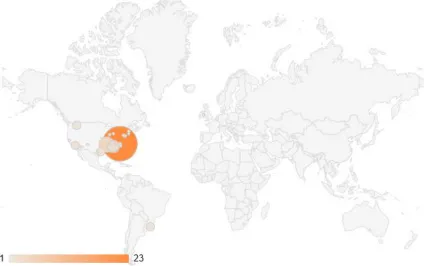
Figure 3.A Total visits to MapMyClients home page by city from January 1, 2013 to February 12, 2013 . . . 41
Figure 3.1 Choropleth/thematic map displaying WNC B&B’s total client count by zip code for the greater Atlanta area . . . 48
Figure 3.2 Example software options for exploring client distributions . . . 49
Figure 3.3 The MapMyClients workflow automated using Python . . . 56
Figure 3.4 The MapMyClients home page . . . 59
Figure 3.5 Map view of WNC B&B’s returned after uploaded . . . 60
Figure 3.6 Total client count (frequency) by zip code for WNC B&B clients in the Charlotte, Greensboro and Research Triangle Area of NC . . . 61
Figure 3.7 Population by zip code for WNC B&B clients in the Charlotte, Greensboro and Research Triangle Area of NC . . . 62
Figure 3.8 Average travel expenditure by zip code for WNC B&B clients in the Charlotte, Greensboro and Research Triangle Area of NC . . . 63
Figure 3.9 Median household income by zip code for WNC B&B clients in the Charlotte, Greensboro and Research Triangle Area of NC . . . 64
Figure 3.10 Median age by zip code for WNC B&B clients in the Charlotte, Greensboro and Research Triangle Area of NC . . . 65
1
INTRODUCTION
Global trends in Internet use, along with technologies for creating and sharing geographic information have led to the rapid development of web-based mapping (Haklay, Singleton, & Parker, 2008). This development occurs as both generic mapping and discipline specific applications that are created with either proprietary, open source or a combination of both proprietary and open source software. For discipline specific applications, the ability to create and share geographic information requires both a thorough understanding of the discipline and a detailed knowledge of the skills and tools necessary for delivering the appropriate mapping content. This section introduces the tourism specific and open source web mapping experiences that laid the foundation for the development of MapMyClients, an open source web mapping system designed for tourism planning and marketing. The two resulting publications from these efforts are included as the following sections. The two sections directly following those publications first present the additional motivations, theoretical contributions and community response to MapMyClients followed by a manuscript detailing the creation and usage of the MapMyClients system. Lastly, expanded map application details, challenges encountered and the future of MapMyClients are discussed.
To establish context for the tourism web mapping system, I conducted a study involving geology tourism operations in North Carolina (NC) State Parks. The book chapter entitled “Geotourism potential in North Carolina: perspectives from interpretation at state parks” in
Geotourism: The Tourism of Geology and Landscape details the qualitative and quantitative results of that study (Supak, Leung, & Stewart, 2010). Spatially significant geology tourism data for 22
2
public engagement. Although these data have not yet been incorporated into a web-mapping application, they have the potential to be web delivered as a suite of layers not dissimilar to the geology layers available in the national atlas (http://www.nationalatlas.gov/mapmaker) (“National Atlas Map Maker,” 2013). Map layers communicating park features with corresponding
interpretations would provide a detailed picture of tourism opportunities within the state that could assist planning efforts for those interested in visiting the state parks system.
3
GIS. The idea of a flexible framework to support diverse web mapping objectives is far from novel; the team at OpenGeo has pioneered this effort by creating a powerful web mapping software suite that is in itself a flexible framework (“OpenGeo Suite,” 2011). Still, despite the ubiquitous nature of web mapping applications, most of those described in the literature are designed for a singular purpose. This effort reverses that trend by deploying a framework that is easily moved and customized to meet specific mapping objectives that serve selected audiences.
In addition to supporting contamination tracking and food recall, a tool such as BETSMap could benefit the tourism industry. For example, the hotel industry is taking various initiatives to promote food safety by adopting the internationally recognized ISO 22000/ food safety management standards or implementing total quality management approaches (Wang, Hung, & Li, 2011). Outside the hotels, cooked street food can play a significant role in visitor attraction because it offers both inexpensive food and insights into the society and heritage of the destination (Henderson, Yun, Poon, & Biwei, 2012). Environmental hazards recognized and tracked on the micro level could help tourist understand the risks associated with travel to a particular region at a particular time. The detailed mapping technology provided by a system such as BETSMap can help a potential tourist make more targeted travel decisions by allowing them to answer the question “Will a current food contamination outbreak affect my travel to region A or is it only a concern for region B which is 200 miles away?” The ability to answer this question could mean the difference between the abandonment of travel plans and travel completion.
4
GIS can be expensive and complex. Yet, the current body of tourism literature does not document the development of any customized web-based GIS applications to address this issue. This dearth of development in web-based GIS is surprising because the utility of a GIS tool to evaluate site-specific tourism demand is well recognized (Miller, 2008). There exists a clear need for prudent market area definition and customer profiling to support the tourism marketing goals of competing for new customers, retaining current customers and striving to balance supply and demand. In these cases, the tourism industry and research community needs an alternative marketing decision support tool that will permit them to use their own consumer related data to capitalize on the value of spatial analytics. This tool should be customized and easy to use, employ open source software to reduce expense and allow for broad accessibility via web delivery. The MapMyClients application described in the manuscript for the Journal of Travel & Tourism Marketing entitled “An Open Source Web Mapping System for Tourism Planning and Marketing” addresses this gap. Specifically, MapMyClients gives users the ability to easily determine and visualize the spatial distribution of client origins and visitation patterns, and it provides other relevant tourism specific and general demographic information. With web-based GIS planning and marketing support, tourism professionals and the researchers who assist them can facilitate effective marketing strategies to create, capture,
5
REFERENCES
Ball, M. (2011, September 14). Who’s Watching Your Food? Spatial Sustain: Promoting Spatial Design for a Sustainable Tomorrow. Retrieved from
http://www.sensysmag.com/spatialsustain/whos-watching-your-food.html
Haklay, M., Singleton, A., & Parker, C. (2008). Web mapping 2.0: the Neogeography of the Geoweb. Geography Compass, 2(6), 2011–2039.
Henderson, J. C., Yun, O. S., Poon, P., & Biwei, X. (2012). Hawker centres as tourist attractions: The case of Singapore. International Journal of Hospitality Management, 31(3), 849–855.
doi:10.1016/j.ijhm.2011.10.002
Miller, F. L. (2008). Using a Gis in Market Analysis for a Tourism-Dependent Retailer in the Pocono Mountains. Journal of Travel & Tourism Marketing, 25(3), 325–340.
National Atlas Map Maker. (2013, January 11). National Atlas. Retrieved January 12, 2013, from http://www.nationalatlas.gov/mapmaker
OpenGeo Suite. (2011, November 10). OpenGeo Suite Community Edition. Retrieved from http://opengeo.org/technology/suite/
Supak, S., Leung, Y. F., & Stewart, K. (2010). Geotourism Potential in North Carolina: Perspectives from Interpretation at State Parks. In Geotourism: The Tourism of Geology and Landscape (pp. 172–183). Oxford: Goodfellow Publishers.
Supak, Stacy, Luo, H., Tateosian, L., Fang, K., Harrell, J., Harrelson, C., … Devine, H. (2012). Who’s Watching Your Food? A Flexible Framework for Public Health Monitoring. Transactions in GIS, Transactions in GIS, 16(2), 89–104. doi:10.1111/j.1467-9671.2012.01309.x
6
34
FRAMEWORK FOR THE TOURISM PLANNING AND
MARKETING WEB MAPPING APPLICATION
Additional Motivation
The combined tourism specific and open source web-mapping experiences detailed in the previous publications helped lay the groundwork for MapMyClients. Other important design considerations were the usefulness of the application to its intended audience and the theoretical contribution of the application. The value of determining spatial demand was made clear to me over the past three years when on multiple occasions I was asked to provide GIS support for my student and faculty colleagues in the Department of Parks, Recreation and Tourism Management at North Carolina State University. The requests were similar in nature and in all instances included the production of maps for visualizing the geographic distribution (origins and groupings) of clients or user groups. Two of these efforts were included in tourism extension reports returned to practitioners to help them address their needs, whether they were to demonstrate the economic impact of collective group of businesses providing similar services (Harrolle et al., 2011) or to aide in increasing demand for their product (Rich, Tomas, Banks, Standish, & Supak, 2010). It became evident that thoughtful visual analysis was needed in these reports; yet, my colleagues had little to no GIS experience and found the need to outsource their creation. These experiences were a major motivating factor behind the design of MapMyClients. To address the needs of my colleagues and the greater tourism
35 Theoretical Contribution
Although the development of MapMyClients addresses practical needs of tourism professionals and researchers, at the same time, it provides a tool with which to test theoretical constructs important to tourism such as market segmentation and tourism flow modeling. Market segmentation is a central concept in both marketing theory and practice (Wedel & Kamakura, 2000). During the Post World War II era, Smith (1956) introduced the concept of market segmentation. The author recognized the existence of heterogeneity in the demand for goods and services, based on the economic theory of imperfect competition (Robinson, 1933). Smith stated: “Market segmentation involves viewing a heterogeneous market as a number of smaller homogeneous markets, in response to differing preferences, attributable to the desires of consumers for more precise satisfaction of their varying wants.” New methodologies of market segmentation continue to evolve and sophisticated modeling techniques currently include clustering methods, mixture models, mixture regression models, mixture unfolding models, profiling segments and dynamic segmentation (Wedel & Kamakura, 2000).
36
becoming generally better educated, older and more affluent with increased distance from the source. In addition, certain market segments identified were found to have increased and decreased through time. These findings have a number of potentially significant implications for destination marketing. This study confirms that the Hong Kong outbound market, like all other geographical regions of tourism demand, is not homogenous. Instead, markets consist of a variety of segments, each with its own unique characteristics that can be better satisfied by some destinations more than others.
One goal behind studies such as McKercher (2008) is to provide practitioners with tourism behavior findings from which they may extrapolate or infer general and specific information that is hopefully applicable to their business. Unfortunately, general findings such as the fact that
geographical regions of tourism demand are not homogenous will not help a practitioner to decide where to spend marketing dollars. Conversely, the specific market profile findings about the Hong Kong residents may be applicable to other markets, but previously there existed no good way for a practitioner to determine if distance from a source results in different market segments for their own customers. Conducting cluster analysis for a single business can be impractical because the training and software expense would unlikely offset the marketing revenue related benefits. This cost benefit tradeoff issue also exists for businesses that would like to conduct spatial analysis using proprietary desktop GIS. This issue is discussed in detail in the next section.
37
extends market segmentation theory and provides a tangible link between research and practitioners. In practice, this will lead to destination managers using their marketing dollars more effectively to reach the most likely consumers.
In addition to market segmentation, identifying spatial relationships is often desirable in order to understand, model and forecast tourism flow and other forms of tourism behavior. Building on the importance of geographic distance to marketing theory and modeling, MapMyClients provides users with the ability to investigate models employed by tourism researchers over the past half century. The distance decay model, utilized in recreation and tourism research in the 1960s and 1970s as a proxy for forecasting, predicts an inverse relationship between distance and willingness to travel. This relationship was based on the observed trade-off between the investment of time, money or effort to achieve the travel and the time one can spend at the end destination. More generally, demand will peak at some distance relatively close to a source market and then decline as distance increases. The theory is said to play an important role in the distribution of ideas, technology, time, population and spatial interactions of various types (Mckercher & Lew, 2003). Although it has fallen into disuse of late, distance decay principles are still implicit in current modeling and forecasting of tourist flows (Mckercher & Lew, 2003) and Eldridge & Jones (1991) go as far as to recognize distance decay as one of the key laws of geography.
38
country/region pairs under consideration and the length of the forecasting horizons concerned. Despite these limitations, model development and specification continues largely using secondary data and either time series or econometric techniques. Among the 121 models examined by Song & Li (2008) published since 2000, the tourist arrival variable is still the most popular measure of tourism demand. Specifically, this variable was measured by total tourist arrivals from an origin to a destination. In many cases, the total tourist travel arrival variable is large in scale and represents data aggregation over a large region or entire county (e.g. Falocci, Paniccia, & Stanghellini, 2009; Khadaroo & Seetanah, 2008). While the total tourist arrival variable remains important to tourism flow and forecasting, the level of data aggregation may make these models less relevant to practitioners who are interested in site-specific forecasting.
MapMyClients investigates total tourist arrivals from origins to a destination. The
destinations, however, are not on a county or regional scale, but rather on an individual business or attraction scale. Given the sensitivity of forecasting model performance described by Li et al. (2005), the existing suite of models may not provide much benefit to practitioners operating on smaller scales. MapMyClients offers an alternative approach to the conventional forecasting models that is more accessible to tourism practitioners. Although future tourism flows cannot be estimated, many of the factors that would be incorporated into a tourism flow model are visually presented in
MapMyClients, such as total tourist arrivals and origin-destination distances. The consideration of these factors is not only useful in understanding the demand for site/event-specific attractions or activities, but future demand can be increased through targeted marketing efforts. Further,
39
client count map supports the model that demand peaks at some distance relatively close to the source and then declines as distance from that source increases.
Community Response
To examine if the scenario described for the Bed & Breakfast example holds true for other tourism enterprises, a usability and usefulness survey was designed and distributed using
SurveyMonkey.com to over 200 tourism practitioners who are members of the Travel and Tourism Research Association (“SurveyMonkey,” 2012). Additionally, the same solicitation was posted on multiple LinkedIn tourism group message boards (e.g. DMAI Convention and Visitors Bureau Network, Travel & Tourism Industry Professionals Worldwide, Travel Media Pros). For the complete survey instrument see Appendix A, and for complete survey results see Appendix B. Although the response rate for the survey has been low, those who did participate provided positive feedback. Survey respondents identified several benefits provided by MapMyClients including the thematic mapping method of visualization, its utility for marketing planning and the variety of supplemental data provided to support their objectives. To illustrate these themes, I have selected a few quotes from the survey results:
"The results confirmed that the target audience for our marketing program was being reached successfully." - Larry Schweinsburg, President, Private Industry
"I could use it for all of my data collected at festivals, events and sporting events." - Jennifer Norman, Executive Director, Destination Management Organization (DMO)
“I will use it to map our client base for all of our channels.”- Brian Jenkins, Director of Business Strategy & Research, Destination Management Organization (DMO)
40
coming from.”- Robert Victor, Research Manager for a Convention and Visitors Bureau, Destination Management Organization (DMO)
"Great as a free application! Also provides features (polygon fills) that are difficult to do in other free web based mapping software." - Anonymous
In addition to the survey responses, my colleague and committee member Sam Rozier Rich has personally benefited from this application in her new business venture. She has the following to say:
“MapMyCients is a valuable and easy to use tool for tourism practitioners. I have already used MapMyClients for two projects and it worked perfectly in allowing me to not only visually illustrate where visitors were traveling from but also to identify key demographic features associated with the data. I hope this software continues to be offered to tourism practitioners so data collected can be used to better inform marketing decisions, funding, and support. Thank you for developing and sharing this tool.”- Samantha Rozier Rich, Lead Researcher, Owner - enRiched Consulting, LLC
From the LinkedIn solicitation, positive feedback continues:
“Hi, Stacy, I represent non-profit Tourist sites and know that your program would be very applicable to identifying and visualizing their visitors and where they are coming from. It would help us in making marketing decisions of where we are drawing from now and where we can go to get more of the same. The visualization is particularly important when working with Boards to help them understand why money needs to be spent in different media in varying locations. Their eyes glaze over when you give them lists and numbers.”- Dianne Powell, President SellMark - full service marketing company
After the official survey period ended, Google Analytics tracking was added to the
41
42 REFERENCES
Eldridge, J. D., & Jones, J. P. (1991). Warped space: a geography of distance decay. The Professional Geographer, 43(4), 500–511.
Falocci, N., Paniccia, R., & Stanghellini, E. (2009). Regression modelling of the flows in an input-output table with accounting constraints. Statistical Papers, 50(2), 373.
Harrolle, M. G., Rich, S. R., Rascher, D., Xu, S., King, M., & Supak, S. (2011). Economic impact study of organized youth camps in Western North Carolina (Buncome, Jackson, Henderson, and Transylvania Counties). NCSU.
Khadaroo, J., & Seetanah, B. (2008). The role of transport infrastructure in international tourism development: A gravity model approach. Tourism management, 29(5), 831.
Li, G., Song, H., & Witt, S. F. (2005). Recent developments in econometric modeling and forecasting. Journal of Travel Research, 44(1), 82–99.
McKercher, B. (2008). Segment transformation in urban tourism. Tourism management, 29(6), 1215. Mckercher, B., & Lew, A. A. (2003). Distance decay and the impact of effective tourism exclusion zones on international travel flows. Journal of Travel Research, 42(2), 159.
Rich, S. R., Tomas, S. R., Banks, C., Standish, K., & Supak, S. (2010). Occupancy analysis of Applewood Manor Inn Bed and Breakfast. Raleigh: North Carolina State University.
Robinson, J. (1933). The economics of imperfect competition. London: Macmillan,.
Smith, W. R. (1956). Product differentiation and market segmentation as alternative marketing strategies. The Journal of Marketing, 21(1), 3–8.
Song, H., & Li, G. (2008). Tourism demand modelling and forecasting—A review of recent research. Tourism Management, 29(2), 203–220.
SurveyMonkey. (2012). Retrieved from www.surveymonkey.com
Wedel, M., & Kamakura, W. A. (2000). Market segmentation: conceptual and methodological foundations. Springer.
43
AN OPEN SOURCE WEB MAPPING SYSTEM FOR
TOURISM PLANNING AND MARKETING
Supak, S., Devine, H., Brothers, G., Rich, S. R. & Shen, W. North Carolina State University
Manuscript in preparation for The Journal of Travel and Tourism Marketing
Abstract
Core retail management functions include defining market areas and profiling customers. For tourism enterprises, a significant percentage of total sales can come from customers who are not permanent residents of the geographic area surrounding stores or attractions, thereby complicating traditional approaches for these activities. The analysis and visualization capabilities of Geographic Information System (GIS) technology is an important business tool in these circumstances because it can effectively model the geographic distribution or dispersion of customers and potential clients. Unfortunately, many businesses may not able to utilize GIS due to its complexity and associated expense. In these cases, the tourism industry and its corresponding research community need an alternative marketing decision support tool that will afford them use of their own consumer related data to capitalize on the value of spatial analytics. This alternative tool should be customized and easy to use, employ open source software to reduce expense and allow for broad accessibility via web delivery. This study develops such a tool and explores its use for tourism planning and marketing. This implementation gives users the ability to easily determine and visualize the spatial distribution of U.S. client origins and visitation patterns, and it provides other relevant tourism specific and general demographic information. This functionality can be beneficial in developing or augmenting business plans and marketing strategies.
44 Introduction
Competing for new customers, while retaining current ones, is a priority for all tourism operations regardless of size, industry or ownership. In retail management, market area analysis, customer profiling, and site selection are key functions at the core of best business practice (Applebaum, 1964; Goodchild, 1984; Huff & Sherr, 1967; Huff, 1964). For tourism-dependent retailers, a significant percentage of sales are to customers who are not permanent residents of geographic area surrounding the store or attraction. Therefore, market area definition and subsequent customer profiling should not be accomplished by simply defining distance rings or drive time polygons with respect to an attraction, but rather they should include techniques which account for the geographic dispersion of customers (Miller, 2008).
45
This leaves that community wanting certain functionality and potentially having too much unnecessary functionality. The application descried here will address this gap.
GIS can add value to market analysis by enhancing direct marketing and micromarketing endeavors via the conversion of data into client intelligence. Elliott-White & Finn (1998) identify this process as actionable competitive advantage. The travel and tourism industry is well suited for spatial analysis, primarily because most transactions produce a record of client names and addresses (Elliott-White & Finn, 1998), allowing for customer specific spatial origin analysis. Tourism organizations with a database of customer street addresses or zip codes can use GIS to generate maps displaying where their customers live in relation to each other and to destinations. The identification of these spatial relationships among tourist origins and their collective relationship to attractions enables the evaluation and targeting of marketing efforts, customization of visitor packages, development of new opportunities and the discovery of potential collaborative arrangements among partners (Chancellor & Cole, 2008). Additionally, this type of analysis can identify customer clusters useful in
determining locations for additional neighborhood level promotions such as newspaper ads or
billboards (Hess, Rubin, & West, 2004). Conversely, limited past customer activity from a geographic area or neighborhood could indicate a potential new target market. Using GIS, potential new markets can be compared both geographically and demographically to current high preforming neighborhoods helping to form or augment marketing strategies. Organizations employing these techniques can evaluate the effectiveness of marketing and other investment initiatives, can better serve current customers and better compete for new customers.
46
4) user training. However, the author acknowledges that due to recent developments in each of these areas, GIS technologies are accessible to more organizations. Additionally, emerging technologies provide more effective ways for diverse user groups to have access to GIS (e.g., Supak et al., 2012). Specifically, development of web-based GIS is improving accessibility and reducing complexity, thereby decreasing user training needs and allowing a wider audience with varied computer and GIS knowledge to participate.
Global trends in Internet use, along with technologies for creating and sharing geographic information through pioneering and often collaborative applications have led to the rapid
47
environmental models by geocoding. These two application examples have less functionality than traditional desktop GIS; however, because these applications are tailored to specific users’ needs and delivered online, they are easier use and access. By limiting the functionality, customized applications allow novice users to perform only the tasks that are critical, thereby removing the complexity of universal multifunctional GIS software. In many instances, the universal multifunctional GIS software may be the only option. Without a customized application, tourism professionals and researchers must find other methods to support planning and marketing objectives.
GIS Options to Support Tourism Marketing Objectives
48
Figure 3.1 Choropleth/thematic map displaying WNC B&B’s total client count by zip code for the greater Atlanta area. The solid red region in north Atlanta and its suburbs represents an abundance of clients and the lack of shading in south Atlanta represents a dearth of clients. This map gives
instantaneous insight as to the effectiveness of geographically targeted current marketing efforts. This intuition also can support the preparation of marketing strategies to inform future campaigns.
49
Figure 3.2 Example software options for exploring client distributions. Each product has at least one limitation related to cost, complexity or display options. These are all universal multifunctional GIS tools, none of which is tourism specific.
For proprietary desktop GIS, ArcGIS 10.1 for Desktop Basic, ESRI’s most minimal commercial release, has a starting price of $1500 that does not include reoccurring licensing fees applicable after the first year (ArcGIS 10.1 for Desktop Basic, 2012). To produce a choropleth map with this product, WNC B&B must first purchase the product, find the proper geometry shapefile (ESRI’s proprietary data format) and then employ someone who is trained in its multifunctional design. Caution must be taken as erroneous outputs are possible when improper or incomplete
50
isolate the required functions out of hundreds to achieve the objective. Specifically, the approach for this objective includes aggregating and geocoding client data on a spatial scale of interest, while ensuring inclusion of all possible data.
Advancements in OSS have transpired recently for both desktop and web-based mapping applications. QGIS is one example of an OSS universal multifunctional desktop GIS counterpart to ArcGIS Desktop (QGIS, 2012). This program is free for download; however, the software user still must have appropriate hardware and the complexity issues described for ArcGIS Desktop still exist. QGIS has a more limited tool set than its costly competitors, but the OSS community continues to develop and update tools regularly. Therefore, QGIS and other similar programs (e.g., GRASS, uDig, OpenJump, gvSIG) make appealing options for users operating in resource-constrained environments who have GIS skills and no reservations about complex software. WNC B&B would save money using a program such as QGIS when compared to ArcGIS Desktop, but all of the complications described above regarding the intricacies of using ArcGIS Desktop to create a choropleth map would still exist. These complications coupled together with limited software support may present too large a challenge for a casual user.
51
for $995 (http://www.esri.com/software/bao/pricing), this tool still may be financially unfeasible for some organizations and limitations still exist in terms of representing users’ personal data. If WNC B&B were to use BAO, managers could easily calculate distance rings or drive time polygons to represent market areas, but this technique would not be appropriate for a tourism business whose clients are dispersed. Alternatively, managers could upload their own client data as a spreadsheet, but they would encounter file size and record number restrictions. Additionally, they could only display their data as points, without the communicative impact of a personalized choropleth map. There is one non-point method to display user data, but it requires an ESRI proprietary shapefile, and it does not support thematic shading. Although this product would provide limited client specific spatial insights for WNC B&B’s, it does provide thematic maps for a huge set of demographic and lifestyle variables at any scale desired.
BatchGeo is an example of a web-based mapping application that utilizes the simple and customizable OSS application program interface Google Map API (BatchGeo, 2012; Crowley, 2011). BatchGeo’s interface is easy to use and there are both a free and professional versions, so a user can choose to eliminate purchase expense entirely. Like BAO, this program offers the ability to input personal client data for geocoding as points, but unlike BAO there is no supporting business data provided to set a user’s information in a broader business context. Additionally, the frequency of clients for any given map point can only be viewed one point at a time by clicking on that point and viewing the pop up window. This product also would leave WNC B&B without the benefit of a choropleth map for understanding the spatial frequency of its clients. As Google and others continue to improve their offerings, a choropleth mapping tool may exist on the horizon. Jackson (2011) believes that OSS will become more common as organizations driving much of the software
52
For those who lack resources for GIS hardware and software as well as other related GIS investments such as training or staff expertise, OSS solutions are desirable (Moreno-Sanchez, Anderson, Cruz, & Hayden, 2007). The generally common aspects of OSS include transparency of development and the freedom to build more complex systems out of readily available building blocks (Kilamo, Hammouda, Mikkonen, & Aaltonen, 2012). OSS components eliminate the need to initially pay for proprietary software, some of which have reoccurring licensing fees. Moreno-Sanchez et al. (2007) catalog some of the other benefits of employing OSS, including user based community development and support, smooth learning curves that make them accessible to more novice developers and more modest computer hardware requirements. Although there are limitations to the services that OSS can provide, some literature proposes that OSS web-based GIS have reached a stage of maturity, sophistication, robustness, stability and user friendliness rivaling that of commercial, proprietary GIS and web-based GIS server products (Boulos & Honda, 2006).
53
Currently in the field of tourism, no descriptions of proprietary or OSS web-based mapping applications appear in the literature. A customized web-based mapping tool is needed to address this application gap. Given the complexity of desktop GIS and the limitations of universal multifunctional web mapping applications, an alternative marketing decision support tool is needed that will allow the tourism industry and research community to capitalize on the value of GIS. The MapMyClients application described here supports that effort as an initial OSS contribution for tourism planning and marketing.
System Requirements and Objectives
Working with tourism research specialists and through the study of related work, the following tourism planning and marketing GIS functional requirements were identified:
• Upload tabular client or transaction data;
• Aggregate client data on a spatial level of interest to determine spatial frequency; • Link spatial frequency client data to tourism specific and general demographic data; • Link spatial frequency client data and demographic data to spatial data;
• Classify and display client frequency data based on classification value as thematic map; • Support rudimentary customer profiling by providing thematic demographic map layers; • View/visualize client data along with other geographic features to provide locational context; • Examine and explore concentrations of desirable or undesirable locations for marketing; • Confirm if targeted marketing effort are successful;
• Use OSS components to provide these services.
54
A user will learn about his or her current clientele. Answering questions such as: where do they live, do they cluster, what characteristics define socioeconomic background can aide users to better service current clientele;
A user can determine if existing marketing efforts are producing clients (if the locations of targeted marketing efforts are known);
A user can determine current clientele profiles to predict future clientele in alternative geographic areas with similar demographics;
A user can then determine whether to market to existing client neighborhoods or the alternative geographic areas discovered through the analysis, or both.
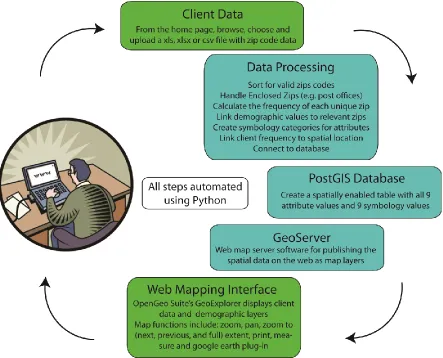
Prototype Development
To meet the functionality requirements as well as the desired objectives specified above, the MapMyClients customized web-based mapping application was developed. Because the software components on which a web mapping systems are built determine its data handling and analytical capabilities (Rinner, Moldofsky, Cusimano, Marshall, & Hernandez, 2011), selection of these components was thoughtful. Ultimately, OpenGeo Suite Community Edition’s three tiered OSS stack was selected (“OpenGeo Suite,” 2011) because it bundles the key software components necessary to deliver the desired web mapping functionality. These components include a spatial database
management system (PostGIS for PostgreSQL), a web map server (Geoserver) and web map application interface software for displaying and manipulating data on the web site (GeoExplorer API). Built with an OSS stack and web delivered, MapMyClients provides ease of access to its users as well possible expansion to mobile devices in the future.
55
the census block and the largest is by region (often containing multiple states). The selection of zip code level aggregation allows for the broadest use of the application because some users may only have access to zip code level data and full address data would require aggregation to some spatial unit.
56
Figure 3.3 The MapMyClients workflow is automated using Python. The backend data processing steps combined with OSS stack components produce a choropleth map with supplemental
demographic layers. Green boxes represent steps where the user can interact and blue boxes are steps that are automated and require no additional effort on the part of the user.
After the replacement of enclosed zip codes, the number of occurrences for each unique zip code with a valid spatial boundary is counted. This count becomes the total client count (frequency) by zip code attribute. All unique zip codes then are matched with supporting data from ESRI’s BAO data repository. The supporting data include six demographic, socioeconomic and consumer behavior metrics: 2010 median age, 2010 median home value, 2010 median income, 2010 percent of
57
average annual dollar amount spent on lodging. Additionally, the 2005 population and population density per square mile for each unique zip code is identified. The distributions of client frequency values and supplemental data values are used to classify each of these nine datasets into three categories of symbology. A quantile style classification methodology was selected as it lets users interpret these categories using the common sense notion of even thirds of data. This classification method aims to put an even number of unique zip codes into high, medium and low groupings, while maintaining uniqueness among the groups. This may lead to an uneven distribution among the categories for some datasets.
58
MapMyClients Prototype Usage Example
59
Figure 3.4 The MapMyClients home page (http://152.1.0.195:8888/mapmyclients/index.html). Demo videos and numbered categories help users choose and upload appropriate client data files.
60
usage, but the word “zip” must appear in the header of the zip code field. Fields other than those with the word “zip” have no influence on the process, so client data file preparation does not require field deletion or any additional user effort. After the managers determine an appropriate file, they only need to click the mouse three times to browse, choose and upload that file. When the managers click the upload button (Figure 3.4), within 20 seconds a new tab will open with a map similar to Figure 3.5.
Figure 3.5 Map view of WNC B&B’s clients automatically returned after the data is uploaded. The client origins are primarily focused in the southeastern US. The table of contents on the left side allow for all ten data layers to be toggled off and on. There are several options for changing zoom level including the drop down menu at the bottom right and the plus/minus navigation bar on top left. The print, measure and Google Earth plugin appear at the top right.
61
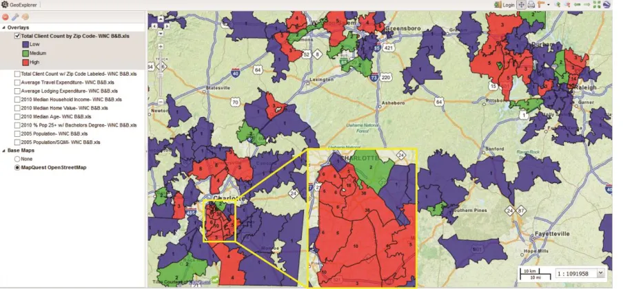
this level of zoom, the color coding of attributes by zip code is discernible as red, green and blue for the high, medium and low values, respectively. In the southern Charlotte metropolitan area, a cluster of 11 zip codes has a total of 105 clients and there is a single zip code among this cluster where 38 clients reside. This visitation pattern would not be discernible by simply looking at the uploaded data file. In the Research Triangle Area, there is a cluster of 34 clients in north Raleigh as well as a cluster of 24 clients in the Chapel Hill area. The Greensboro and Winston-Salem areas have client clusters with lower client frequencies comparatively, but these areas support the pattern observed across central NC of urban and suburban interest in WNC B&B. Investigation of the 2005 population map layer (Figure 3.7) helps elucidate how client clusters are influenced by total population. The noted areas of concentrated clients not surprisingly have some of the highest total populations. If managers are unfamiliar with the region, examination of the 2005 population density map layer (not shown) could help them differentiate which areas are urban, suburban and rural.
Figure 3.6 Total client count (frequency) by zip code for WNC B&B clients in the Charlotte,
62
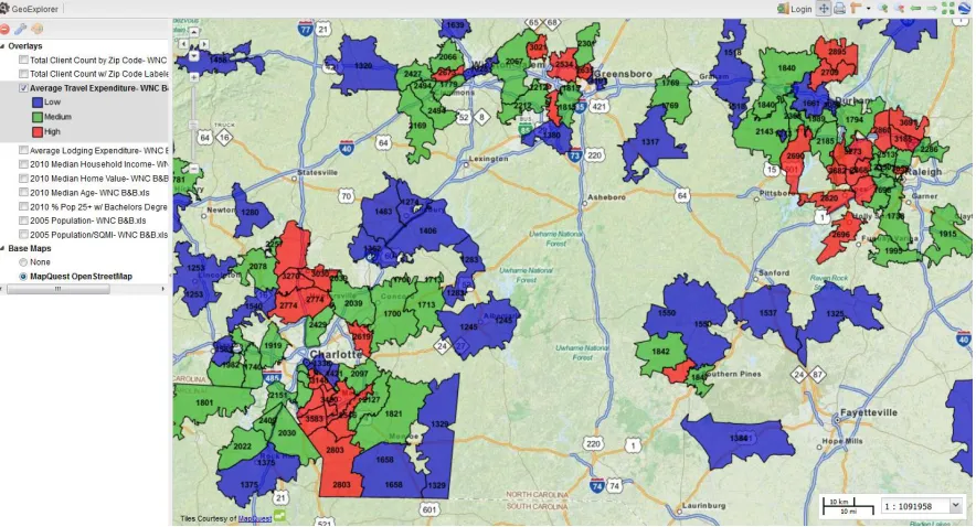
Figure 3.7 Population by zip code for WNC B&B clients in the Charlotte, Greensboro and Research Triangle Area (Raleigh, Durham & Chapel Hill) of NC. This map layer is useful in determining if/how population influences the total client count. A population density map layer is also available for assessing the level of urbanization.
63
income map layers. The same urban and suburban areas with high client frequencies tend to have lower median ages and a higher percentage of the population over 25 years of age with a bachelor’s degree, relative to the surrounding rural areas. Identifying these urban and suburban client clusters where younger, higher income, higher educated people spend more on travel allows WNC B&B to refine its current marketing strategies. These specific areas could benefit from additional
neighborhood level promotions such as billboards or newspaper ads or if WNC B&B managers are already employing targeted marketing efforts in these areas, this map could validate their current marketing strategy.
64
65
66
Figure 3.11 Percent population over 25 years of age with a bachelor’s degree by zip code for WNC B&B clients in the Charlotte, Greensboro and Research Triangle Area (Raleigh, Durham & Chapel Hill) of NC. Managers continue to grow a customer profile after examining this map layer. Their high client count zip codes or customer clusters are in urban and suburban areas where the population is more likely to be highly educated, younger, earn higher incomes, and spend more money on travel.
This prototype has been in place since November 2012. Both Google Analytics and a usability/usefulness survey using surveymonkey.com (“SurveyMonkey,” 2012) are in place to track usage and catalog general feedback that may be helpful for improving future versions of the
application. From Google Analytics, repeat visitors represent above 40% of total web traffic for the home page, indicating that MapMyClients provides a service that is attractive enough to sustain participation. The survey results generally support the application is meeting its design objectives with responses such as “[MapMyClients] confirms that the target audience for our marketing program was being reached successfully.” Potential improvements mentioned in the survey include the
67
uploaded data such as the total dollar amount spent or total room nights stayed (for hotel data) was mentioned in one survey response. This option would require more user input for all users and because only some users would have numeric attributes to take advantage of this feature, this functionality was not included in the initial prototype of MapMyClients.
Constraints & Conclusions
MapMyClients illustrates the value of determining client frequency clusters and identifying demographic characteristics based on geographic locations for the purposes of understanding existing customers more fully and targeting new prospects more precisely. Aggregating client data on the zip codes scale for choropleth map display allows for the identification of clusters or regions of high interest in tourism services. Additional demographic information associated with these zip codes provides a simplistic method for customer profiling; however, associating demographic
characteristics to zip codes is not without weakness. The caveat to the approach of using zip codes scale demographic information is the lack of precision achieved. The substantial assumption that the characteristics of a ZIP code as a whole are homogeneous and a reasonable approximation of each household in that ZIP code may not be valid. See Miller (2008) for a detailed discussion of the benefits and limitations of using zip codes and census block groups for demographic proxies. Given that this tool is fulfilling an application gap with no software expense to the user and it is intended for those who may not have previously utilized GIS due to its complexity or cost, the lack of within zip code demographic precision should not deter potential MapMyClients users. The general
demographic pattern of variability from zip code to zip code in conjunction with the client origin concentration results should satisfy the data precision needs of various tourism businesses.
68
69 REFERENCES
Applebaum, W. (1964). Store location research-A survey by retailing chains. Journal of Retailing, 48(2), 53–56.
ArcGIS 10.1 for Desktop Basic. (2012). ESRI. Retrieved from
http://store.esri.com/esri/showdetl.cfm?SID=2&Product_ID=29&Category_ID=121 BatchGeo. (2012). Retrieved from www.batchgeo.com
Bell, R. R., & Zabriskie, N. B. (1978). Assisting Marketing Decisions by Computer Mapping: A Branch Banking Application. Journal of Marketing Research, 122–128.
Boulos, M. N. ., & Honda, K. (2006). Web GIS in practice IV: publishing your health maps and connecting to remote WMS sources using the Open Source UMN MapServer and DM Solutions MapLab. International Journal of Health Geographics, 5(1), 6.
Chancellor, C., & Cole, S. (2008). Using Geographic Information System to Visualize Travel Patterns and Market Research Data. Journal of Travel & Tourism Marketing, 25(3), 341.
doi:10.1080/10548400802508440
Chen, R. (2007). Geographic information systems (GIS) applications in retail tourism and teaching curriculum. Journal of Retailing and Consumer Services, 14(4), 289–295.
Cinnamon, J., Rinner, C., Cusimano, M. D., Marshall, S., Bekele, T., Hernandez, T., … Chipman, M. L. (2009). Online map design for public-health decision makers. Cartographica: The International Journal for Geographic Information and Geovisualization, 44(4), 289–300.
Crowley, S. (2011, June 16). Visual geo tracking data with batchgeo. Dirigo Design & Developement. Retrieved from http://www.dirigodev.com/blog/visual-geo-tracking-data-with-batchgeo/
Dragićević, S., Li, S., Brovelli, M., & Veenendaal, B. (2011). Pervasive Web Mapping, Geoprocessing and Services. Transactions in GIS, 15(2), 125–127. doi:10.1111/j.1467-9671.2011.01251.x
Elliott-White, M. P., & Finn, M. (1998). Growing in Sophistication: The Application of Geographical Information Systems in Post-Modern Tourism Marketing. Journal of Travel & Tourism Marketing, 7(1), 65–83. doi:10.1300/J073v07n01_05
ESRI Business Analyst Online. (2012). ESRI. Retrieved from http://www.esri.com/software/bao Frehner, M., & Brandli, M. (2006). Virtual database: Spatial analysis in a Web-based data
management system for distributed ecological data. Environmental Modelling & Software, 21(11), 1544–1554. doi:10.1016/j.envsoft.2006.05.012
70
Goodchild, M. F. (1984). ILACS: A Location-Allocation Model for Retail Site Selection. Journal of Retailing, 60(1), 84.
Grimshaw, D. J. (1999). Bringing geographical information systems into business. Wiley.
Haklay, M., Singleton, A., & Parker, C. (2008). Web mapping 2.0: the Neogeography of the Geoweb. Geography Compass, 2(6), 2011–2039.
Hall, G., Chipeniuk, R., Feick, R., Leahy, M., & Deparday, V. (2010). Community-based production of geographic information using open source software and Web 2.0. International Journal of
Geographical Information Science, 24(5), 761–781. doi:10.1080/13658810903213288
Hess, R., Rubin, R., & West, L. (2004). Geographic information systems as a marketing information system technology. Decision Support Systems, 38(2), 197–212. doi:10.1016/s0167-9236(03)00102-7 Huff, D. L. (1964). Defining and estimating a trading area. The Journal of Marketing, 28(3), 34–38. Huff, D. L., & Sherr, L. A. (1967). Measure for determining differential growth rates of markets. Journal of Marketing Research, 4(4), 391–395.
Jackson, J. (2011, November 3). Open Source vs. Proprietary Software. PCWorld Business Center. Retrieved from
http://www.pcworld.com/businesscenter/article/243136/open_source_vs_proprietary_software.html Kearns, F., Kelly, M., & Tuxen, K. (2003). Everything happens somewhere: using webGIS as a tool for sustainable natural resource management. Frontiers in Ecology and the Environment, 1(10), 541– 548.
Keenan, P. (2005). Concepts and Theories of GIS in Business. Geographic information systems in business, 1.
Kilamo, T., Hammouda, I., Mikkonen, T., & Aaltonen, T. (2012). From proprietary to open source-Growing an open source ecosystem. Journal of Systems and Software, 85(7), 1467–1478.
doi:10.1016/j.jss.2011.06.071
MacEachren, A. M., Crawford, S., Akella, M., & Lengerich, G. (2008). Design and Implementation of a Model, Web-based, GIS-Enabled Cancer Atlas. Cartographic Journal, 45(4), 246–260.
doi:10.1179/174327708X347755
McAdam, D. (1999). The value and scope of geographical information systems in tourism management. Journal of Sustainable Tourism, 7(1), 77–92.
Miller, F. L. (2008). Using a Gis in Market Analysis for a Tourism-Dependent Retailer in the Pocono Mountains. Journal of Travel & Tourism Marketing, 25(3), 325–340.
Moreno-Sanchez, R., Anderson, G., Cruz, J., & Hayden, M. (2007). The potential for the use of Open Source Software and Open Specifications in creating Web-based cross-border health spatial
71
OpenGeo Suite. (2011, November 10). OpenGeo Suite Community Edition. Retrieved from http://opengeo.org/technology/suite/
Python. (n.d.). Retrieved from www.python.org QGIS. (2012). Retrieved from http://www.qgis.org/
Rinner, C., Moldofsky, B., Cusimano, M. D., Marshall, S., & Hernandez, T. (2011). Exploring the Boundaries of Web Map Services: The Example of the Online Injury Atlas for Ontario. Transactions in GIS, 15(2), 129–145. doi:10.1111/j.1467-9671.2011.01247.x
Serrano, S., Jiménez-Hornero, F. J., Gutiérrez de Ravé, E., & Jodral, M. L. (2008). GIS design application for “Sierra Morena Honey” designation of origin. Computers and Electronics in Agriculture, 64(2), 307–317.
Supak, S., Luo, H., Tateosian, L., Fang, K., Harrell, J., Harrelson, C., … Devine, H. (2012). Who’s Watching Your Food? A Flexible Framework for Public Health Monitoring. Transactions in GIS, Transactions in GIS, 16(2), 89–104. doi:10.1111/j.1467-9671.2012.01309.x
SurveyMonkey. (2012). Retrieved from www.surveymonkey.com
Tiwari, C., & Rushton, G. (2010). A Spatial Analysis System for Integrating Data, Methods and Models on Environmental Risks and Health Outcomes. Transactions in GIS, 14, 177–195. doi:10.1111/j.1467-9671.2010.01220.x
72
EXPANDED MAP APPLICATION DETAIL, CHALLENGES
ENCOUNTERED AND THE FUTURE FOR MAPMYCLIENTS
The internet has profoundly changed the way we derive and share information. With the explosion of web-based mapping and web-based GIS, new instances of customized, cost effective, user friendly applications appear regularly. These applications are described in the literature for landscape ecology (Frehner & Brandli, 2006), natural resource management (Kearns, Kelly, & Tuxen, 2003), forest management (Xie et al., 2011), agriculture (Serrano, Jiménez-Hornero, Gutiérrez de Ravé, & Jodral, 2008), public participatory GIS (Hall, Chipeniuk, Feick, Leahy, & Deparday, 2010) and public health (MacEachren, Crawford, Akella, & Lengerich, 2008; Supak et al., 2012) among other disciplines. Despite the great potential for web-based mapping in field of tourism, no customized web mapping instances appear in tourism literature. Although MapMyClients is a first step to addressing this gap, many improvements can be made to the existing implementation. The inclusion of additional demographic and social data (e.g home ownership, social network usage and presence of children) was a theme in the survey responses. Also, the application could support more user specific map layers for attributes provided in the uploaded data, such as the total dollar amount spent by clients or total room nights stayed (for hotel data). This option would require more user input for all users and because only some users would have numeric attributes to take advantage of this feature, this functionality was not included in the premier version of MapMyClients.
73
subject to spatial uncertainty or the lack of knowledge about an object’s geographic position or value. Spatial uncertainty can be due to varying quality in data collection methods or to errors in the
assignment of data values to geographic locations (geocoding). In both mapping applications, data collection occurred outside of the application and by unknown methods, making quantification of spatial uncertainty problematic. For BETSMap, the geographic positions (i.e., longitude, latitude) for the state-regulated food service facilities reside in an Oracle Locator database previously geocoded using an unknown method. For this reason, spatial uncertainty in terms of both data collection and geocoding are potentially large in this application; however, one of the GIS tools developed for BETSMap provides the ability to update the location of any facility on the map and in the database by clicking and dragging the facility map marker to the correct location. Also, additional facilities can be added to the map and database as needed. These functionalities can support map accuracy, reduce spatial uncertainty and promote map completeness through investigation and validation, so that users can better take advantage of the full content of the available data.
74
reducing the file size to within 25% of the size.” Further it states that by generalizing the topology, the positional accuracy is reduced and cannot be determined.
When producing a thematic map that can be used for pattern recognition, spatial uncertainty can not only arise from issues related to data quality and geocoding, but it also can arise from the choice of method to visualize patterns and relationships between variables. Specifically, the choice of classification schemes, the cutpoints (boundaries between categories in a map legend) and the spatio-temporal window for data representation all can effect spatial uncertainty (“Spatial Uncertainty: Data, Modeling, and Communication (R21),” 2011). It is also important to note that the scale of spatial data aggregation can influence pattern recognition. Because BETSMap does not produce a thematic map, these issues will only be discussed for MapMyClients. Please see the Prototype Development section of the manuscript “An Open Source Web Mapping System for Tourism Planning and Marketing” for a discussion of the data aggregation scale choice for MapMyClients.
75
uncertainty. In the web-mapping environment, results need to be consistent and streamlined for novice users, so a single classification scheme was adopted.
I chose to use the quantile classification method with only three data classes because application users can easily understand the commonsense notion of even thirds of data, regardless of statistical knowledge. Although the distribution of these categories aims to put an even number of unique zip codes into high, medium or low groupings, maintaining uniqueness among the groups was imperative; therefore, for some datasets, there may be an uneven distribution among the categories. This method performs well when the data are linearly distributed and can be visually misleading when observations with widely different values get placed in the same category. For this reason, labels are used to identify all data value for each US zip code for every map layer, so if widely
different values are placed in the same category, a user will be aware of that issue. For the purposes of understanding the origins and clustering of customers, the potential for incorporating population into the result can be desirable, especially if the goal is to identify areas for geographically targeted marketing promotions. However, thematic maps that display count variables can be misleading because they may reveal nothing more than population trends (Monmonier, 2005). To address this issue, both population and population density map layers are presented to the user. Future versions of MapMyClients could include an additional map layer showing the client count normalized by
population count for each zip code. Transforming a measure of magnitude (total client count) into a measure of intensity (client count per capita) would allow for neighboring zip codes to be compared on more equal terms.
76
attraction should peek at some distance near to the attraction and then drop off with increased distance. Within an applied buffer capturing this peek, high client count locations could be compared to other locations with observed low client or no client counts. Unfortunately, due to the discreet nature of client data, comparisons using no client locations within the buffer would not be supported by the supplemental demographic data provided for areas with at least one client.
Another improvement to MapMyClients would be the inclusion of a model, such as ordinary least squares (OLS) regression, to identify relevant predictors (demographic attributes) and to estimate the effect of these predictors on total client count. Unfortunately, spatial data exhibit two properties that make it difficult to meet the assumptions of traditional (non-spatial) statistical methods, such as OLS regression. First, geographic features are more often than not spatially auto-correlated. This means that features near each other tend to be more similar than features that are farther away, which results in an over-count type of bias. Second, geography is an important factor of spatial data and often the processes most important to the model are non-stationary, meaning that these processes behave differently in different parts of the study area. The use of a geographically weighted regression (GWR) technique specifically developed to be robust to these two characteristics of spatial data would be preferable to an OLS regression model; however, employing either of these modeling techniques could increase the complexity for the user. Although customer profile
improvements may be possible, caution must be taken when adding any additional functionality as to not introduce undue complication.
Beyond supporting practitioners in their own planning and marketing objectives,