International Journal of Multidisciplinary and Scientific Emerging Research
©2014 IJMSER, All Rights Reserved
Available at http://www.ijmser.com/ (ISSN 2349 – 6037)
117 Int. J. of Multidisciplinary and Scientific Emerging Research, Vol.6, No.2 (August 2017)
The Role of Open Sources in Rural Areas Water Harvesting
Gar Al-nabi Ibrahim Mohamed1and Faisal Al-thobiani2
1
Hydrographic Surveying Department, Faculty of Maritime Studies, King Abdulaziz University, KSA. 2Department of Marine Engineering, Faculty of Maritime Studies, King Abdulaziz University, KSA.
Accepted 20July2017, Available online 17August 2017, Vol.6, No.2 (August 2017)
Abstract
The paper investigated the collection, processing, analysis and presentation of the topographic information required for locating a rainfall water draining site, using open data sources and free of charge application programs. The effort made in this investigation clearly revealed the important role of these inputs in obtaining a huge volume of draining water in one site. A water volume that is hundreds of times that of a traditional hafeer can be harvested in one draining site (93,330,400m3/300,000m3= 311 approx.). This allows for supplying a group of villages/agricultural camps by drinking water in the nearby area. Applying this technique insures harvesting the required volume of water in dry rainfall seasons. Hence open data sources and free of charge application programs can play an important role related to the provision of drinking water for both humans and animals in rural areas world-wide.
Keywords: Hafeer, residential area, draining area, draining site, drinking water, rainfall rate, open source.
1. INTRODUCTION
Water is life, it is very essential for all creatures in general and humans and animals in particular. Sudan suffers from the problem of drinking water deficit for both humans and animals, particularly in rural areas where the rainfall water represents the main source for drinking water throughout the year. In rural areas water is collected and stored in
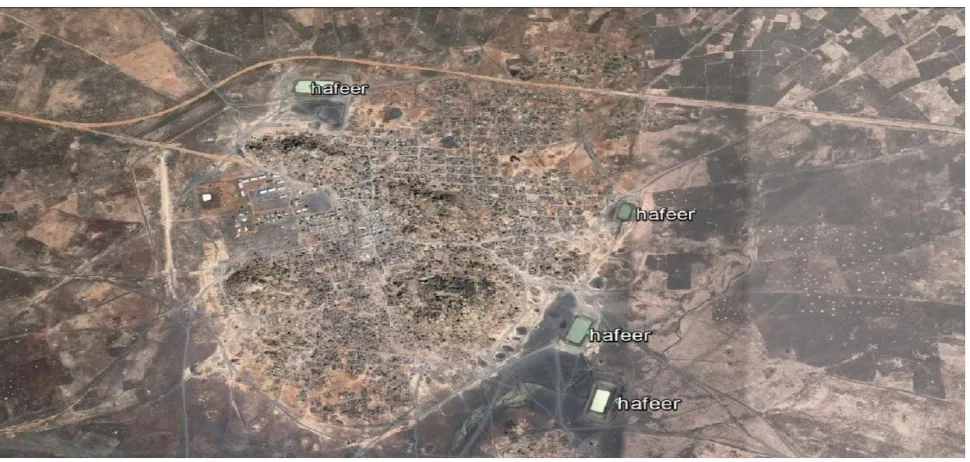
what is locally known as hafeer (small earth embankment water reservoir). Figure 1, shows a typical residential area with some of these hafeers in the nearby area. The location selection of these hafeers is mainly based on the experience of the local people in the area and thevolume of water stored is usually not sufficient for supplying drinking water for both humans and animals in the area.
The effort made in this paper is directed towards the collection, analysis and presentation of topographic data required for selecting a draining sitelocation that provides a large volume of draining water,using the free of charge open data sources and application programs. This provides a sufficient water supply for both humans and animals in the area throughout the year.
2. THE STUDY AREA
The study area is located in Aldamazin locality, Blue Nile state, Sudan (Savannah zone). It is an agro-pastoralist
area, where livestock and crop production
are practiced. Although this area is characterized by a very high rate and long period of rainfall during the rainy season which extends, from May to October. The average annual rainfall in the area is 300-900 mm [7].
Also, the area is dominant by a very dense drainage network and rain water flows by gravity directly to the Blue Nile. Unfortunately, water deficit is one of the characteristics of the area, especially in summer, where animals were forced to travel long distances to reach the Blue Nile and farmers use trucks and tankers to transport water from it.
Figure 2: The General Location of the Study Area.
Figure 3: The Drainage Network in the Area.
So, after the end of the rainy season water is available only in hafeers and the water bonds scattered in the area. The bonds water is consumed
119 Int. J. of Multidisciplinary and Scientific Emerging Research, Vol. 6, No.2 (August 2017) The decisions to construct these small hafeers
are politically based and mainly resulted from the pressure exerted by the local inhabitants and their representatives in the local governments to quench the thirst of the inhabitants of a certain area.
3.RESEARCH OBJECTIVES
The main objective of this research is to provide the topographic information required for a scientifically based decision related to the selection of the water harvesting site, using the free of charge open data sources and application programs. Also, to allow for the location of a water harvesting site that provides enough water supply for both humans and animals throughout the year.
4. RESEARCH DATA AND SOFTWARE.
The data and application programs used in this research comprises the following:
a) The free of charge Shuttle Radar Topography Mission Digital Elevation. Model90 for the area. b) The free of charge Google earth satellite images
for the area.
c) The free of charge QGIS application program, version 2.18., Google Earth-client, supported by Microsoft Office application programs (Word, Paint etc.).
5.METHODOLOGY
The research methodology adopted in this investigation may be summarized by the following:
a) Google Earth satellite images were used to select the targeted project area, based on the topography, distribution of inhabitants, and the drainage network in the area.
b) The SRTM90 digital elevation model of the area was preprocessed to fill the sinks which can alter the water flow in the area and turned into a
hydrologically correct digital elevation model,where streams will at least behave logically according to hydrological rules.
c) The corrected digital elevation model (depression less model) was used to derive theflow direction and flow accumulation rasters for the area. d) The draining site was defined and the draining
area was delineated and vectorized to allow for the calculations of the drainage volume.
6. RESULTS.
Table 1, below presents the results obtained for a typical example of the draining sites which can be scientifically located, based on the topographic information of the area, which can be obtained from the free of charge open data sources. Moreover, preprocessing, processing, analysis and presentation are carried out using free of charge application programs. Although the average rainfall rate falls between 300 and 900 mm, but the volume of the draining water in cubic meters was calculated, based on the minimum rainfall rate in the project area (300 mm). This is mainly to account for the dry rainfall seasons in the area.
Location (m)
Area (km2)
Perimeter (Km)
Draining water volume (m3) 574531 E
1256848 N
624.436 183.972 187,330,800
Table 1:The Draining Site Information.
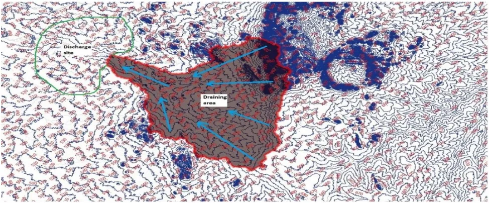
Figure 4: below shows the resulted drainage area (catchment area) and the drainage site (discharge site) for the project.
7. DISCUSSION
Table 1, indicated that using the required topographic data of the area allows for the harvesting of a huge volume of water in one draining site, compared to the traditional water harvesting method using the hafeer. The average hafeer storage capacity in the area ranges between 150,000 to 300,000 cubic meters. The data presented in table 1, indicated that the capacity of the investigated site is hundreds of times that of the hafeer. So, if only 50% of the site draining water is harvested (precipitation, evaporation etc.), 93,665,400 cubic meters of water can be harvested in one draining site. This is a huge volume of water and it can be redirected to villages/agricultural camps in the area by constructing draining canals depending on the topography of the area. Applying the minimum rainfall rate in the area and assuming the harvesting of only 50%
of the draining water grantee the continuous annual supply of the draining water even in dry rainfall seasons.
Figure 1, clearly indicated that the local inhabitants together with the local authorities made an effort and did their best to quench the thirst in the area, but their effort was not scientifically based. They managed to construct four hafeers in the village area but still local inhabitants are suffering and facing drinking water deficit, especially during the summer season. This is the exact time for crops harvesting in the area. During this period farmers have to transport water from the Blue Nile using trucks, with the obvious side effect of increasing the crops production cost, hence razing the crops cost in the region and the whole country. Also, animals have to travel tens of kilometers for drinking water in the Blue Nile.
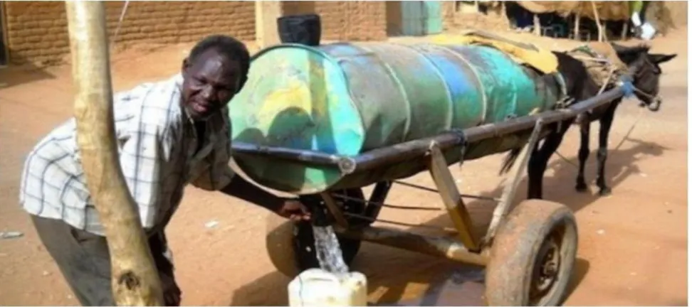
Figure 5:Atypical Mean of Transporting Drinking Water from Hafeers.
121 Int. J. of Multidisciplinary and Scientific Emerging Research, Vol. 6, No.2 (August 2017) 8: CONCLUSIONS
The effort made in the paper clearly revealed that the free of charge open data sources, coupled with the free of charge application programs can play an important role in providing a sufficient water supply for both humans and animals in the project area. This will no doubt decrease the cost of crops and livestock production and improve the living standard in the area.
Needless to say, that the hafeer provides water supply for only one village/agricultural camp while such a large water harvesting site which is most likely to be an earth dam or dams, with the minimum concrete constructions required for water inlet, spilling and outlets can provide water supply for a group of villages/agricultural camps in the area. A detailed ground survey, using total station or RTK GPS instrument is required for the design and construction of these earth dams.
Also, such large water harvesting sites allow the possibility of supplying water to the nearby villages/agricultural camps through a pipeline network. This saves the cost and effort made to transport water using traditional means and decreasing the environmental impacts in the area by increasing the green area and minimizing the fuel and spare parts consumption.
It should be mentioned that non-governmental organizations (NGOs) are making an appreciated effort related to drinking water supply in the area. However, unfortunately their effort is confined to the construction of hafeers and pumping wells, in areas where ground water is available. Hence the availability of such topographic information will enrich their effort in the area.
REFERENCES
[1] Shuttle Radar Topography Mission (SRTM),
internet site: http://www.cgiar-csi.org/data/srtm-90m-digital-elevation-database-v4-1
[2] http://en.acolita.com/catchment-delineation-with-qgis.html.
[3] https://support.dronesmadeeasy.com/hc/en- us/articles/217759823-Using-QGIS-to-make-custom-Contour-Maps.
[4] https://web.ics.purdue.edu/_vmerwade /education/terrain_processing,pdf
[5] http://countrystudies.us/sudan/33.htm
[6]
[7] https://sustainabledevelopment.un.org/