2623
Way-Finding Guidance Using AR Technology
Faris Abuhashish
Abstract: Todays’ technology that is improved with varied immense features and superb quality characteristics allows the developers of software packages to innovate the finest imaginable software inventions, regardless of the context of the specific issue. Augmented Reality (AR) technology, is employed nearly all types of areas in this century. Augmented reality will become an unseamed practice as a part of everyday life like wearable technology and mobile devices. Within this work context, an intelligence AR application is developed regarding mobility navigation for the University of Petra in Amman-Jordan that enables students, visitors and staff to find the exact location inside the campus besides it facilitates explore its environment. Moreover, the Augmented Reality UOP-WF-AR system has the ability to retrieve campus lecturer's and officials' details and give direction in an outdoor location as well. The proposed UOP-WF-AR system is expected to help and guide university students, visitors, and staff, by providing helpful navigation information at outdoor locations and check and provide details about the availability of lecturer and officials at any time if they are not at their office.
Index Terms: AR, GPS, POI, UOP-WF-AR.
—————————— ——————————
1.
INTRODUCTION
General Positioning System (GPS), gyroscope and compass are the main purposes of uses for direction finding and tracking, consequently, several sensors are employed in mobile systems for that purpose. Augmented reality application is stimulated by the navigation feature in order to further developed and possible easily use or conveniently daily basis. The proposed project aims to make the University of Petra smart campus by developing guidance for wayfinding. The student, staff, or visitor will be able to find the required location by using the attractive and interesting integrated mobile AR app. According to Fraga-Lamas et al. [1] study, augmented reality is subjected to immense development, especially in navigation methods. Many researchers explored augmenting virtual objects methods like tracking and registration. Fuchsová et al. [2] stated that the tracking method in the construction of a precious AR system is an essential element. Many tracking methods are categorized into two classes: sensor-based and based method. The vision-based method concludes the captured scene pose from the camera, a camera device is needed in order to acquire the required information for the tracking process. The main issue of this method is the ability of the system to conclude the relation between virtual objects and the real environment when slowly capturing image sequences [3]. In the past, the vision-based method utilizes a marker of fiducials to support the system in analyzing the features through clarifying the conclusion to the related fiducials. Black square markers are used by the AR Toolkit library for the tracking procedure [4]. Berkovich et al. [5], [6], [7], [8] stated that several markers have been proposed. Due to the simplicity of markers, robust and fast augmented reality experience can be delivered by marker-based technique. A comparative survey of the performance of many marker-based techniques shows contrast [9]. On the opposite side, the sensor-based tracking method depends on special sensors like initials or ultrasonic and camera indeed. Augmented is done to the scene captured through the camera after provided the environment information to the system by sensors. The previous method incorporates a GPS sensor and ultrasonic in order to obtain their position
regarding point of calibration [10], [11], [12]. Direct spatial information is provided to the system through accelerometers and gyroscopes as inertial sensors. To calculate users’ position like the pose of the camera the sensors are mounted on a position to the user near to the camera. Despite its performance, markers usage restraints the domain of implementation of such methods as in an outdoors scenes or indoor scenes. Consequently, the latest methods concentrate more on improving tracking methods through complete utilizing the features that are captured from scenes like nooks, edges, etc., and conclude the pose of the camera based on markerless tracking. Some methods use a pre-trained model such as CAD. Photographs are used as a calibrating model, like a visual vocabulary bi-clustering process [11], [13]. Preceding research comes up with detection of planar in unfamiliar locations such as surface, wall and working field with no predefined knowledge, such as location-based or marker. If there is no prior information for tracing, it will be considered as a difficult mission. For that reason, the previous research holds out a restriction for planar tracing portions separately [4]. Various AR tracing methods focus more on the unknown environment and tracing planar. It attempts to presume the tracing lack of initial information of the scene and set the data in the specific pattern of a maps book. Usually called simultaneous localization and mapping (SLAM), once new views were exposed, it magnifies the maps book so the information produces exponentially. SLAM is used in order to erect models based on the captured scene [14], [15].
PTAM introduces another method through the mapping process and separating tracking while supplying a strong SLAM method [14], [15]. The camera pose is calculated from the map by tracking the thread method and in the meantime, further reliable feature is added by the mapping process. SLAM requires a lot of computational costs when tracking many features on a map. So as to develop a smooth interaction between the virtual and real environment, the tracking method used not only requires strength but also computational efficiency. The desired goal behind this research comes from the extreme need of quite precise markerless tracking in unknown surroundings through feature-based tracking. In order to complement such issue direct information obtained from sensors is used. The proposed method is a hybrid tracking system that cooperates SLAM method to improve inertial sensors and feature maps to assist the motion evaluation of camera motion regarding the map. However, there are many methods have been studied in the context of using AR and VR [16], [17, [18].
————————————————
2624
2 WAY-FINDING IMPROVED BY AR
The Digital Signage Association claims that, due to both the augmented technology and the virtual reality developments, we are reaching a second wave in 3D features in wayfinding development. Wayfinding applications using AR technology provide users with an effective manner reach the intended route. The software displays interactive guidance and descriptions to direct user where he wants, as user keep his mobile device in a direct position in front of his face. Improved wayfinding by augmented reality will optimize location's geographical, social and cultural characteristics. Through exchanging current information on the history or culture of a site through the visible line on a device connected, augmented reality is able to strengthen the understanding of environments through new innovative interactions with historical buildings and installations. wayfinding can involve with users, jointly nearby inhabitants and guests, in new intuitive ways. Locations’ visitors with augmented reality wayfinding services gain a better understanding of their environment and a better aware of the culture and history of the site. Wayfinding with augmented reality will improve even our location, exhibits and surroundings experiences through attempting to link what we currently see with a large online collection of scriptural, sound and visual information.
3 METHODOLOGY
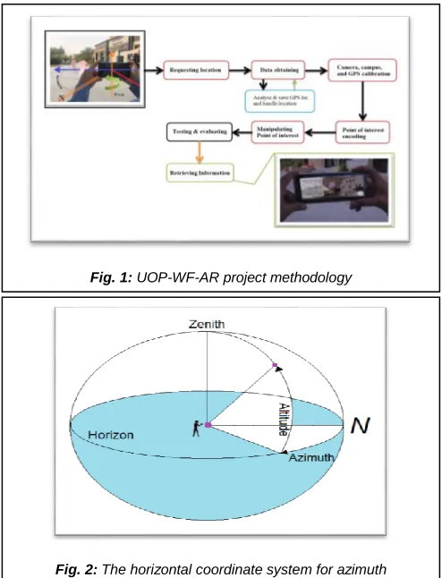
The main explanation is GPS doesn't work inside. The second is inside conditions are innately perplexing. Google Maps for instance report fixed structures, for example, avenues, streets, houses and structures in an open air condition. They gather and consolidate satellite symbolism with ethereal photography, road maps and 360-degree road perspectives and offer clients area knowledge in a hurry unrestricted by concrete. As indicated by analyst Krukar et al. [19] indoor situations include an unpredictable arrangement of psychological procedures to find your right location by your own. Figure 1 illustrates the proposed method, it shows how data is gathered in addition to managing locations of GPS and shows the use of the camera, campus and sensors of GPS calibration for location determining. The encoding point of interest (POI) starts after determining the location. In the end, manipulating the POI like insert, delete and update. The used devices to accomplish the experiment are android devices laptops with high GPU and CPU. The distance between the endpoint and the position of the camera is calculating by the following process steps:
1. GPS coordinate for the required destination is stored in the database.
2. Obtain GPS coordinates of the mobile phone.
3. Read from the database the stored GPS coordinate of the destination.
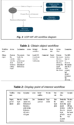
4. The direction (azimuth) is computed based on GPS coordination (Figure 2).
5. Provide and render POI of the current direction (azimuth) of the mobile device.
Figure 2 illustrates the human position with regards to azimuth toward earth direction. Length and azimuth are the two parameters that must be specified to determine a reference location related to the current location of the university building. The latter would actually be between two points by the straight-line distance if the earth considered to be flat. Since the earth is spherical, so, it will be considered as the quickest destination distance between the two locations. The calculation for the distance between two locations, the Haversine formula has been used in the azimuth calculations. Chopde et al. [20] stated that haversine formula, is the formula that define the distance of the great-circle among two locations on a sphere regards to their latitudes and longitudes, refer to ―Eq. 1‖, ―Eq. 2‖ and ―Eq. 3‖. It is a particular instance of a more general method in spherical trigonometry in term of significance of direction finding, the haversines law connects angles and sides of triangles of spherical:
𝛼 = sin2(∆𝜑/2) + cos𝜑1 × cos𝜑2 × sin2(∆𝜆/2) (1)
𝑐 = 2 × 𝑎tan2 [√𝑎, √(1−𝑎)] (2)
𝑑 = 𝑅 × 𝑐 (3)
Where:
φ₁ is the latitude of initial point (positive for N and negative for S);
φ₂ is the latitude of the final point (positive for N and negative for S);
λ₁ is the longitude of the initial point (positive for E and negative for W);
λ₂ is the longitude of the final point (positive for E and negative for W);
Δφ = φ₂ - φ₁;
Fig. 1: UOP-WF-AR project methodology
2625 Δλ = λ₂ - λ₁;
R is the radius of the Earth, expressed in meters (R = 6371 km).
By using the same longitude and latitude, the azimuth can be found with the following equation, refer to ―Eq. 4‖:
𝜃 = 𝑎tan2 [(sin 𝛥𝜆 × cos 𝜑₂), (cos 𝜑₁ × sin 𝜑₂ − sin 𝜑₁ × cos
𝜑₂ × cos 𝛥𝜆)] (4)
4 SEMI-ORGANISED
INTERVIEWS
To acquire direct bits of awareness, I conversed with new comers using a semi-organized interview around the campus which are consented to be difficult finding the right location. With the supervision of the Visitors, Public & Intel. Relations department at the university, I established my interview questions with population of the 27 participants selected by the Visitors, Public & Intel. Relations department at the university indiscriminately. In order to encourage participants to share as many perceptions as possible, I requested from them to answer my proposed questions informally. The observations were split between ordinary visitors, staff, and students and new visitors, staff, and students who are the focal point and essential judgement of this phase. All the information collected was anonymised, so that the results presented in this study did not identify the participants. Rating the wayfinding technique in the form of 1 to 10 scaling method has been requested to do from the respondents to show its intuitive, 10 indicates ―extremely intuitive‖ whereas 1 indicates ―absolutely not intuitive‖. It was also motivating to note the recurrence wayfinding technique usage. While there are not enough respondents to classify the findings as common figures, it is worth noting the great difference between ordinary visitors, staff, and students using written maps in relation to first time visitors, staff, and students. Respondents were also asked to propose various solutions to promote easier navigation and communication technique.
5 SUMMARY ANALYSIS
In brief, the observations and replies revealed important points and requirements. In accordance with in-depth analysis, the interviews and notes of observation results helped to create suggestions. For example, with the user's orientation the top view map will ideally be dynamic. Implement augmentation description like what on tombstones may help to attract attention more visitors. Intuitive guidance and indications are required to find places easier and faster.
6 RESULT
The proposed system come up with several features in the context of user interaction with the developed application in term of non-functional and functional requirement, a workflow diagram in Figure 3 illustrates the proposed system. Calibrate the camera: The user must specify the places by directing the camera only to the required location or by providing the location radius that the user aims to travel without typing. The appeared menu showing a tab called track location, which the user has the ability to access. The required location is connected to GPS and start real-time track. The developed application starts reads the longitude and latitude of the location of the current user then it will display all points of interest within the location radius. The system admin saved all points of interest previously in order to use them to calculate
the distance between the required and current location. The result will be shown visually through tags or labels. When the user touches each tag or label, the details of the place will be displayed with entrance wayfinding, image, and contact details i.e. number and e-mail. Tracking of location: Device location could be tracked by a sensor that supplies a real coordinate of any device like mobile phone, radar, and sonar. The latitude and longitude of any device will be created based on the global geographic information system i.e. Google map. Display of point of interest: Shows these points of interest with the related information on the map. A map is created for the University of Petra and the surrounding region inside the developed application. Once the user specifies and inputs the required location, the application checks and compares the data with the nearest locations and then point out tags on the map related to the appeared places. Application user: In Figure 3 the user of the proposed application represents visitor or newly registered student. The workflow description of the system and user illustrated in Tables 1, 2, and 3.
Table 1: Obtain object workflow
Table 2: Display point of interest workflow
2626 Table 3: Information retrieve workflow
7 DISCUSSION
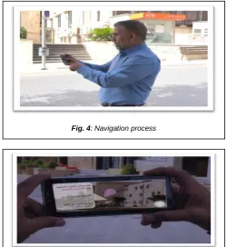
One of the most important features of the UOP-WF-AR project is real-time location tracking of the building on campus. Another feature is the possibility of tracking and directing the user towards the desired direction and showing the distance, in addition to portraying all the information about the destination. Figure 4 illustrates the navigation process of wayfinding while using the AR app. Figure 5 illustrates the wayfinding result of the Faculty of Architecture & Design location at the University of Petra. And as shown, the most important appeared information is the faculty name and the distance from the mobile location to the destination which is about 65 meters which is in red color for attention. To load the location map 21.3 MB, lunch AR application 79% CPU is required to render, GPS usage 26%, uploaded Wi-Fi data 208 KB, downloaded 7.56 KB and Power consumption 4.35 mAh, refer to Table 4. These increments in memory and CPU due to utilizing the camera, GPS sensor, and gyroscope simultaneously.
Table 4: Memory and CPU analysis.
8
CONCLUSION
Augmented Reality application is an easy-to-use application that helps and guides visitors, newcomer's students or staff to easily explore the location of the campus. The proposed application main objective is to facilitate the wayfinding of the University of Petra location and surroundings for the users. As demonstrated in the discussion part, the apps’ user can clearly determine and mark out the required location along with detailed direction and distance displayed by the camera mobile phone of the user, in addition to navigation further details of the point of interest related to the required location. The developed AR application facilitates outdoor and indoor wayfinding of the campus for students, visitors, and staff, which in turn, adds a positive impact to the university. With regards to users' feedback, the easiness of using the app prompted them to enjoy while using the app and thus they encouraged others to use it. Since it saves effort and time while moving inside the campus especially the newcomer's students and staff in addition to visitors that is considered an advantage that primarily distinguishes the app from other apps.
ACKNOWLEDGMENT
The author is grateful to the deanship of scientific research at the University of Petra, Amman-Jordan for supporting this research.
REFERENCES
[1] Fraga-Lamas, P., Fernández-Caramés, T. M., Blanco-Novoa, Ó., & Vilar-Montesinos, M. A. A review on industrial augmented reality systems for the industry 4.0 shipyard. IEEE Access, 6, 13358-13375, 2018. https://ieeexplore.ieee.org/stamp/stamp.jsp?arnumber=82 98525. DOI: 10.1109/ACCESS.2018.2808326.
[2] Fuchsová, M., Adamková, M., & Lapšanská, M. P. Uses of Augmented Reality in Biology Education. In Augmented Reality in Educational Settings (pp. 168-194), 2019. Brill Sense. DOI: 10.1163/9789004408845_008.
[3] Pai, Y. S., Yap, H. J., Dawal, S. Z. M., Ramesh, S., & Phoon, S. Y. Virtual planning, control, and machining for a modular-based automated factory operation in an augmented reality environment. Scientific reports, 6, 27380. DOI: 10.1038/srep27380, 2016.
[4] Billinghurst, M., Clark, A., & Lee, G. A survey of augmented reality. Foundations and Trends® in Human–Computer Interaction, 8(2-3), 73-272, 2015. DOI: 10.1561/1100000049.
[5] Berkovich E, Littwitz E, Adler A, inventors; Rafael Advanced Defense Systems Ltd. Network-based real time registered augmented reality for mobile devices. United States patent
US 9,240,074, 2019.
https://patentimages.storage.googleapis.com/aa/74/c6/fb0 e3fd5fc1b2a/US9240074.pdf. (Accessed on January 20, 2019).
[6] Sagitov, A., Shabalina, K., Lavrenov, R., & Magid, E. Comparing fiducial marker systems in the presence of
Fig. 4: Navigation process
2627 occlusion. In 2017 International Conference on
Mechanical, System and Control Engineering (ICMSC) (pp. 377-382), May 2017. IEEE. DOI: 10.1109/ICMSC.2017.7959505.
[7] Garrido-Jurado, S., Munoz-Salinas, R., Madrid-Cuevas, F. J., & Medina-Carnicer, R. Generation of fiducial marker dictionaries using mixed integer linear programming. Pattern Recognition, 51, 481-491, 2016. 10.1016/j.patcog.2015.09.023.
[8] Díaz, Á., Peña, D., & Villar, E. Short and long distance marker detection technique in outdoor and indoor environments for embedded systems. In 2017 32nd Conference on Design of Circuits and Integrated Systems (DCIS) (pp. 1-6), November 2017. IEEE. DOI: 10.1109/DCIS.2017.8311629.
[9] Christen, O., Naroska, E., Micheel, A., & Ruan, S. J. Target marker: A visual marker for long distances and detection in realtime on mobile devices. In 2nd International Conference of Machine Vision and Machine Learning.
August 2015.
http://www.avestia.com/EECSS2015_Proceedings/files/pa pers/MVML339.pdf. (Accessed on November 7, 2018) [10] Viertler, F., & Hajek, M. Dynamic registration of an optical
see-through HMD into a wide field-of-view rotorcraft flight simulation environment. In Display Technologies and Applications for Defense, Security, and Avionics IX; and Head-and Helmet-Mounted Displays XX (Vol. 9470, p. 94700Y), May 2015. International Society for Optics and Photonics. https://doi.org/10.1117/12.2176190
[11] Huang, J., Mori, T., Takashima, K., Hashi, S., & Kitamura, Y. IM6D: magnetic tracking system with 6-DOF passive markers for dexterous 3D interaction and motion. ACM Transactions on Graphics (TOG), 34(6), 217, 2015. DOI: 10.1145/2816795.2818135.
[12] Blanco-Pons, S., Carrión-Ruiz, B., Duong, M., Chartrand, J., Fai, S., & Lerma, J. L. Augmented Reality markerless multi-image outdoor tracking system for the historical buildings on Parliament Hill. Sustainability, 11(16), 4268, 2019. DOI: 10.3390/su11164268.
[13] Prakash, P., & Kannammal, K. E. Dynamic hand interaction in handheld AR. In 2016 International Conference on Computer Communication and Informatics (ICCCI) (pp. 1-6), January 2016. IEEE. DOI: 10.1109/ICCCI.2016.7479964.
[14] Khairuddin, A. R., Talib, M. S., & Haron, H. Review on simultaneous localization and mapping (SLAM). In 2015 IEEE International Conference on Control System, Computing and Engineering (ICCSCE) (pp. 85-90), 2015. IEEE. DOI: 10.1109/ICCSCE.2015.7482163.
[15] Taketomi, T., Uchiyama, H., & Ikeda, S. Visual SLAM algorithms: a survey from 2010 to 2016. IPSJ Transactions on Computer Vision and Applications, 9(1), 16, 2017. DOI: 10.1186/s41074-017-0027-2.
[16] Abuhashish, F.A., Sunar, M.S., Kolivand, H., Mohamed, F. and Mohamad, D.B. Feature extracted classifiers based on EEG signals: A survey. Life Science Journal, 11(4). http://www.lifesciencesite.com/lsj/life1104/050_19623life11 0414_364_375.pdf, 2014. (Accessed on February 10, 2019).
[17] Abuhashish, F.A.M., Kolivand, H. and Shahrizal, M. Framework Of Controlling 3d Virtual Human Emotional Walking Using BCI. environment, 2, p.4, 2015. http://researchonline.ljmu.ac.uk/id/eprint/8073/. (Accessed
on February 15, 2019).
[18] Abuhashish, Faris A., Jamal Zraqou, Wesam Alkhodour, Mohd S. Sunar, and Hoshang Kolivand. Emotion Interaction with Virtual Reality Using Hybrid Emotion Classification Technique toward Brain Signals. International Journal of Computer Science & Information Technology 7, no. 2 (159), 2015. DOI: 10.5121/ijcsit.2015.7214
[19] Krukar, J., Hölscher, C. & Conroy Dalton, R. Künstl Intell 31: 185, 2017. https://doi.org/10.1007/s13218-016-0483-3 [20] Chopde, N. R., & Nichat, M. Landmark based shortest
path detection by using A* and Haversine formula. International Journal of Innovative Research in Computer and Communication Engineering, 1(2),
298-302, 2013.