e- ISSN: 2278-067X, p-ISSN: 2278-800X, www.ijerd.com
Volume 14, Issue 9 (September Ver. II 2018), PP.68-73
Sea Level Changes in Izmir Bay
E Çoşkun
1and L Balas
21 Environmental Sciences, Gazi University, Ankara, Turkey
2 Civil Engineering Department, Gazi University, Ankara, Turkey
Corresponding Author:E Çoşkun
ABSTRACT.
The semi-diurnal tidal range is small along the Turkish coastline, being in the order of 30 cm. Therefore, sea level changes, are largely influenced by changes in air pressure and wind parameters. In this study, meteorological changes are related to seawater level changes. İzmir Bay located in the Aegean Sea of Turkey is chosen as the application area. Sea level, wind speed and direction, and pressure data of 1999-2016 measured at Menteş Station in the Bay have been analyzed. Hourly wind speed and direction measurements at nearby meteorological station have been used as well in the long term wind analyses. The twenty-five-hour moving average filter is applied to eliminate the tidal effects on the sea level measurements. The reverse barometer effect that is the one cm sea level drop corresponding to the one mb pressure increase, is calculated, and the barometric pressure effect from the sea level data has also been eliminated. For the remaining data, wind surge has been performed. It has been observed the local meteorological contribution appears to be the most important in regional sea level variations. In İzmir Bay, the observed sea level variations result mainly from the combination of two elevations: astronomical tides and surges. While the former is of minor importance; being ±15 cm, the latter may reach up to 1.0 m elevation under the effect of the meteorological factors.--- --- Date of Submission: 18-12-2018 Date of acceptance: 31-12-2018 ---
---I.
INTRODUCTION
The tidallevel change shave little effect onse alevelalong Turkish coastline.Therefore, sealevel changes in Turkey, largelyin fluenced by changes in airpres sure andwind parameters. Tidal cyclesaredividedmainlyinto three groups: diurnaltides, semi-diurnaltides, and mixed semi-diurnaltides.The lunarday is the time it takesfor a specific site on the Earth torotatefrom an exactpointunderthemoontothe samepoint.A solar day is 24-hours, and a lunarday is24 hoursand 50 minutes. The daily tidalcy cleconsists of a highand a low tide everylunarday.Thelunardiurnaltidal constituentis termed as O1. A semi-diurnaltidal cycle consists of two high
and two low tides, almost equal in size every solarday[1].
The tidal components differ with location. The dominant diurnaltidalconstituentsare K1(lunar), O1(lunar), P1(solar), Q1 (larger lunare lliptic), and S1(solar), with periods of 23.93, 25.82, 24.07, 26.87, and 24.0 h, respectively. The semidiurnaltidal constituentsare M2 (principallunar), S2 (principalsolar), N2 (larger lunarelliptic), andK2(lunisolar), withperiods of 12.42, 12.00, 12.66, and 11.97 h, respectively. Thesum of thesetidalsinusoidal wave shaving different periods results in a spring-neaptidal range. Ifthetidal range is lessthantwometers, theregion is classified as microtidal (tidal range< 2 m), if it is in betweent woand four meters, region is classified as mesotidal (2 m <tidalrange< 4 m), if it is in between four and six meters, region is classified as macrotidal (4 m <tidal range< 6 m), and if it is more than six meters, region is classified as hypertidal (tidalrange> 6 m)[2].
IntheMediterraneanSea, the four most significant tidal constituents recordedare M2, S2, K1, and O1 [3].
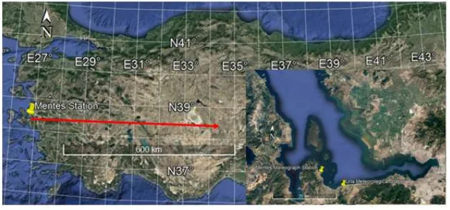
Figure 1. Location of Menteş Station in İzmir Bay.
It is known that the impact of global warming on the world and the Mediterranean region is undeniable. Many studies show that with the melting of the poles, there is a significant increase in the global average sea water level. The water level rise in the Mediterranean occurs at a low rate. However, the projections show that between 2021 and 2050, sea level increase is expected between 7 and 12 cm [6].
In order to serve the needs related to sea level changes, General Command of Mapping (HGK) recordslong-term sea level changes on Turkish coastline. Turkish National Sea Level Monitoring System(TUDES) has been established by a tidal gauge networkin accordance with the Global Sea Level Observing System Standards(GLOSS). HGK is the coordinator of a regional early warning system in Turkey, providing support with real-time sea level data from the tidal gauge stations. TUDES consists of a total of 20 stations located at Turkish coastline [6] .
II.
MATERIAL AND METHOD
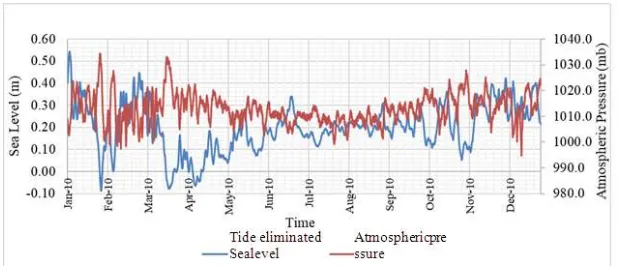
In this study, sea level, wind speed, wind direction,andbarometric pressure data between 1999-2016 of HGK's Menteş station (Figure 1) were used in order to investigate the effect of meteorological parameters on the sea level changes. The sea level changes obtained from the measurements of the Menteş tidal gauge station include the tidal sea level constituents by the movements of the Moon and the Sun. As an example of mixed tidal constituents effects on sea level, annual investigation in 2010 of Menteştidal gauge station is presented in Figure 2. Therefore, in order to examine the sea level changes where meteorological parameters are effective, first of all, tidal data should be filtered from the measurements. There are a few common filters like the walking weighted average filter, the Lanczos-window cosine filter, the Butterworth filter and the Kaiser-Bessel filters applied in coastal data analyses[7]. In this study, the twenty-five-hour moving average filter is applied to eliminate the diurnal and semi-diurnal tidal effects from the sea level measurements[8]. Raw data and tidal effects eliminated sea level changes measured at Menteş station are given in Figure 3 for 2010 as an example. A similar procedure has been applied to all of the data annually between 1999-2016.
Figure 3. Menteştidal gauge station sea level changes in 2010
The changes in barometric pressure, wind speed and direction are also quite effective on the sea level changes.Changes in atmospheric pressure cause sea level () to change in the vertical direction.At seasonal and longer time scales, the sea level is expected to react as an inverted barometer (IB) to changes in atmospheric pressure, so as the atmospheric pressure rises, the sea level drops.Such isostatic response is described simply by
= −𝐩
𝐠##(𝟏)#
where p is change in atmospheric pressure, g is gravitational acceleration and is the density of sea surface.Therefore, one millibarincrease in atmospheric pressure results in anearlyone centimeter sea level decrease.
Tidal constituents eliminated sea level changes according to atmospheric pressures in 2010at Menteştidal gauge station is given as example in Figure 4.Similar analyseshave been performed to all of the data annually between 1999-2016.
Figure 4. Tidal constituents eliminated sea level changes according to atmospheric pressures in 2010at Menteştidal gauge station
It has been seen that, as an example, in mid-March 2010, the pressure was higher than 1030 mb, while the sea level decreased nearly to -0.07 m. While the pressure tended to decrease, sea level tended to increase. Again in late January 2010, the pressure increased to 1035 mb and sea level decreased nearly to -0.09 m.
The average of all pressure datain between 1999-2016 at Menteş station was calculated to be 1015.08 mb. Therefore, in order to remove the pressure effect from the tidal influence eliminated sea level values, each pressure value was subtracted from the mean value of 1015.08 mb and the inverted effects on the sea level were calculated [9]. In this way, the pressure effect was removed from thetidal influence eliminated sea level measurements as well and therefore the sea level changes free of tidal and pressureeffects were obtained to analyze the wind shear responses.
The wind drag force on the sea surface is an important effect that causes the sea levelchanges. The
(a) (b)
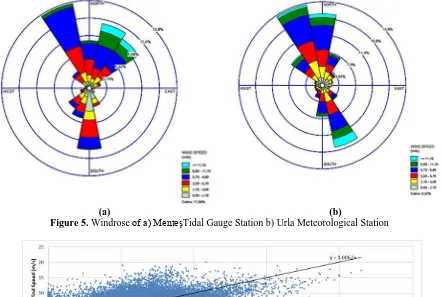
Figure 5. Windrose of a) MenteşTidal Gauge Station b) Urla Meteorological Station
Figure 6. Wind speed comparison ofMenteşTidal Gauge Station to Urla Meteorological Station
It has been observed that the dominant wind direction for MenteşStation measurements is NorthNorthWest(NNW) with an occurrence probability of nearly 17%. Likewise,Urla Meteorological Station measurements indicate the same dominant wind direction with an occurrence probability of nearly 20%. Wind speed comparisons of two measurement stations were supported each other.
Figure7. Effect of wind speed in N-S direction on sea level changes in 2010 atMenteşTidal Gauge Station
Figure8. Effect of wind speed in E-W direction on sea level changes in 2010 atMenteşTidal Gauge Station
It has been observed generally that as the wind is blowing strongly from North to South clockwise directions, there occurs a sea level increase. With the effect of strong winds blowing from the east, sea level decrease has been observed generally.Analyses of all sea level data have shown that sea level increased in time on the average by an amount of 11 cm in between 1999-2016 based on the Menteş Tidal Gauge Station sea level measurements.
III.
CONCLUSIONS
[8]. Ponte R M 2006 Low-Frequency Sea Level Variability and the Inverted Barometer Effect American Meteorological Society pp 619-29
[9]. Smith, Stephen. (2016). Contributions of recentbarometricpressuretrend storates of sealevelrise in southeastern Massachusetts (USA). RegionalStudies in Marine Science.
[10]. Gualdi S,Somot S,Li L, Artale V, Adani M, et al 2013The CIRCE simulations: RegionalClimate Change Projections with Realistic Representation of the Mediterranean Sea. Bulletin of the American Meteorological Society 94 (1) pp 65-81
ACKNOWLEDGEMENT
The authors gratefully acknowledge the data support of the General Command of Mapping and Turkish State Meteorological Service.