World Maritime University World Maritime University
The Maritime Commons: Digital Repository of the World Maritime
The Maritime Commons: Digital Repository of the World Maritime
University
University
World Maritime University Dissertations Dissertations
11-5-2017
Analysis of causes and possible methods of dealing with
Analysis of causes and possible methods of dealing with
mangrove deforestation in Mozambican coastal areas: a case
mangrove deforestation in Mozambican coastal areas: a case
study of Quelimane District in Zambézia Province
study of Quelimane District in Zambézia Province
Mustafa Cesar Paulino Unaite
Follow this and additional works at: https://commons.wmu.se/all_dissertations
Part of the Environmental Policy Commons
Recommended Citation Recommended Citation
Unaite, Mustafa Cesar Paulino, "Analysis of causes and possible methods of dealing with mangrove deforestation in Mozambican coastal areas: a case study of Quelimane District in Zambézia Province" (2017). World Maritime University Dissertations. 576.
https://commons.wmu.se/all_dissertations/576
WORLD MARITIME UNIVERSITY
Malmö, Sweden
ANALYSIS OF CAUSES AND POSSIBLE
METHODS OF DEALING WITH MANGROVE
DEFORESTATION IN MOZAMBICAN COASTAL
AREAS:
A case study of Quelimane District in Zambézia Province
By
UNAITE CÉSAR PAULINO MUSTAFA
Mozambique
A dissertation submitted to the World Maritime University in partial
Fulfilment of the requirements for the award of the degree of
MASTER OF SCIENCE
In
MARITIME AFFAIRS
(MARITIME SAFETY & ENVIRONMENTAL ADMINISTRATION)
2017
ii
iii
ACKNOWLEDGEMENTS
For the success in achieving this goal, firstly, I express my deepest gratitude and
praises to Jehovah God for giving me life and health, which enabled me to reach this
point in my life.
Secondly, I thank all who directly and indirectly supported and contributed to my achievement, and they are:
The Mozambican National Maritime Institute (INAMAR) and its governing body for the opportunity granted to accomplish the MSEA specialization at WMU. Thank you.
The Norway Government for the financial support granted for my study expenses at
the WMU and my stay in Malmö/Sweden. I thank you for the privilege.
A special thank you and appreciation goes to my supervisor Professor Larry
Hildebrand who patiently supervised, corrected, commended and gave insightful
suggestions during all phases of the elaboration of this dissertation. In addition, I am
utterly grateful for his sacrifice, encouragement and wisdom which guided me
throughout the process, once again, thank you.
I thank the WMU faculty as a whole, the ESSP teachers, the MSEA professors, and
general staff, who with professionalism, expertise and dedication have played their
roles.
I would like to thank the former Director of DPMAIPZ, Dr. Madede, to Mr. Pedro,
Director of KRUSTAMOZ Fishing Company in Quelimane, Dr. Portugal from
DPTADERZ of Zambézia, the AQUAPESCA Company and DPSZ, for having
provided relevant and useful information used for this research.
I thank all my classmates of MSEA 2017 for all the happy and sad moments we
iv
I thank my sisters-in-law Christine and Celina for lovingly and patiently caring for
my children during my absence, especially during the months when my wife visited
me in Malmö.
To my uncle and aunt, Jambo and Francisca, I express my profound gratitude for
having provided me impartial education which has led to this day. Thank you.
Finally, to my wife Christabell Ayuma Mutefula Mustafa, I express my sincere
gratitude for the exceptional emotional and physical support throughout my studies. I
thank her for being strong, courageous and playing the role of father to our two
children Rellkine and Chunaite during my absence.
This realization would not have been attained without them. Thank you.
v
ABSTRACT
Title of Dissertation: Analysis of Causes and Possible Methods of Dealing with Mangrove Deforestation in Mozambican Coastal Areas: A Case Study of Quelimane District in Zambézia Province.
Degree: MSc
This dissertation addresses to the destruction of mangrove forests and the resulting environmental and social impact, analysing strategies that can be implemented to cease mangrove deforestation along coastal areas.
For the past century, Quelimane coastal area has been widely affected by mangrove deforestation and today it is part of the livelihood of the majority of the coastal communities who face economic difficulties due to unemployment and high poverty rates. As a means of survival, mangrove forests are their last resort, they burn the mangrove wood to make charcoal for commercial use and for the construction of precarious housing of clay and sticks. Furthermore, the practice of agriculture and aquaculture have also contributed to mangrove deforestation.
The Government as a whole and the Quelimane District Environmental Authority face challenges in fighting deforestation. Although there are laws established against deforestation, little is done due to the ever-increasing population living in poverty and the Governments financial limitations to aid the communities. In addition, the socio- political state stands as another drawback to the implementation of the environmental laws, whereby the environmental related institutions are governed by different political parts. Positively, Quelimane City Counsel launched a reforestation campaign, which promotes awareness and involves the participation of the communities.
After having identified the predominant causes of mangrove deforestation, the results of the research pave the way for recommendations and practical methods that can help in the case of law enforcement for the benefit of both the local communities and preservation of mangrove forests. The recommendations in regard to the measures to be enforced not only involve action from the government, but also include the cooperation of the coastal communities.
vi
Table of Contents
Declaration ... ii
Acknowledgements ... iii
Abstract ... v
List of Tables ... ix
List of Figures ... x
List of Abbreviations ... xii
1.0 INTRODUCTION ... 1
1.1 Background ... 1
1.2 Status of Mozambican Mangrove Conservation ... 3
1.3 Aim and Objectives of the Research ... 4
1.3.1 Aim of the Research ... 4
1.3.2 Objectives of the Research ... 4
1.4 Methodology ... 4
1.5 Limitations of the Research ... 5
1.6 Structure of the Research ... 6
2.0 DATA COLLECTION AND RESULTS ... 7
2.1 Data Collection ... 7
2.1.1 Questionnaire Guide ... 8
2.1.2 Interview Guide ... 8
2.2 Summary Results of the Research ... 9
2.2.1 Questionnaire Results ... 9
2.2.2 Interview Results ... 10
3.0 LITERATURE REVIEW ... 12
3.1 Background ... 12
3.2 Mozambican Mangrove Distribution ... 12
vii
3.4 Mangrove Forest ... 15
3.5 Importance of Mangroves in Maintaining the Marine and Coastal Environment ... 16
3.5.1 Fisheries ... 17
3.5.2 Shoreline Protection ... 19
3.5.3 Shelter to Biodiversity ... 19
4.0 MANGROVE DEFORESTATION IN QUELIMANE DISTRICT ... 21
4.1 Current State of Mangrove Deforestation ... 21
4.2 Causes of Mangrove Deforestation in Quelimane ... 21
4.2.1 Rural Exodus ... 21
4.2.2 Land for House Construction ... 22
4.2.3 Source of Construction Material ... 25
4.2.4 The Practice of Agriculture ... 29
4.2.5 Commercial and Energy Source ... 31
4.2.6 Land for Aquaculture ... 34
4.3 Implementation and Enforcement of National Environmental Laws Related to Mangrove Ecosystem ... 37
4.3.1 Implementation - Political and Strategic Framework ... 37
4.3.2 Implementation - Legal Framework ... 39
4.3.3 Implementation - National Institutions Related to Mangroves ... 42
4.3.4 Enforcement of the Domestic Laws Related to Mangrove Ecosystem Management ... 45
4.4 Socio-Political Issues that Might Lead to Quelimane Mangrove Deforestation ... 46
4.4.1 Socio-Political State ... 46
4.4.2 Poverty ... 47
4.4.3 Financial Limitations ... 49
viii
5.1 Coastal Erosion ... 52
5.2 Reduction of Biodiversity ... 55
5.3 Health Problems ... 58
6.0 MANGROVE RECOVERY PROCESS AND THE PHILIPPINES EXPERIENCE ... 62
6.1 Recovery of mangrove degraded areas ... 62
6.1.1 Rehabilitation ... 62
6.1.2 Restoration ... 63
6.2 Aspects to Consider in Relation to Recovery of Mangrove Ecosystem ... 64
6.2.1 Selection of Species ... 64
6.2.2 Recovery Strategies of Degraded Mangrove Forests ... 64
6.3 The Philippines Experiences on Mangrove Recovery ... 65
6.3.1 Planting and Rehabilitation of Mangrove Forests ... 66
6.3.2 Community and Local Government Initiatives ... 67
6.3.3 International Assistance: Government Projects of Large Scale ... 68
7.0 CONCLUSION AND RECOMMENDATIONS ... 71
7.1 Conclusion... 71
7.2 Recommendations ... 73
References ... 76
Appendices ... 84
Appendix 1. Interview guide to the Quelimane residents on mangrove lands ... 84
Appendix 2. Questionnaire guide directed to the DPTADERZ ... 86
Appendix 3. Questionnaire guide directed to the DPMAIPZ ... 87
ix
List of Tables
Table 1. Mangrove Distribution in Mozambique ... 13
Table 2. Period of mangrove Land Occupation in Quelimane ... 24
Table 3. Number of Houses in Quelimane According to Material Used ... 28
Table 4. Political and Strategic Framework Applicable to the Management of
Mangrove Ecosystem ... 38
Table 5. National Legal Framework for Mangrove Ecosystem Management ... 39
x
List of Figures
Figure 1. Location of Mozambique in African Continent and its Territorial
Distribution ... 2
Figure 2. Schematic representation of the benefits of mangroves ... 17
Figure 3. Main activities of the Population living on mangrove lands in Quelimane ... 18
Figure 4. Part of Mangrove Areas Deforested for House Construction at Liberdade ... 22
Figure 5. Houses Built on Mangrove Lands at Mirazane ... 22
Figure 6. Houses on Mangrove land at Mirazane ... 23
Figure 7. Vast Areas of mangrove Deforested at Icidua ... 23
Figure 8. Houses on Mangrove Land at Chuabo- Dembe ... 24
Figure 9. Reasons for Mangrove Land Habitation ... 25
Figure 10. Construction of Precarious Houses at Liberdade Neighbourhood ... 26
Figure 11. Construction of Precarious House at Chuabo Dembe ... 26
Figure 12. Mangrove Sticks in a Precarious House Construction at Mirazane ... 27
Figure 13. Houses Made with Mangrove Sticks and Clay Sand on Mangrove Lands ... 27
Figure 14. Various Houses on Mangrove Lands at Icidua ... 28
Figure 15. Mangrove Lands Converted Into Rice Field at Mirazane ... 29
Figure 16. Mangrove Lands Converted Into Rice Field at Chuabo Dembe ... 30
Figure 17. Part of Sweet Potatoes Field on Mangrove Land at Chuabo Dembe ... 30
Figure 18. Mangrove Sticks on Sale at Mirazane Market ... 31
Figure 19. Mangrove Sticks on Sale at Mirazane ... 31
Figure 20. Mangrove Sticks on Sale at Icidua Market ... 32
Figure 21. Mangrove Sticks on Sale at Icidua ... 32
Figure 22. Charcoal from the Burning of Mangrove Trees on Sale at Mirazane ... 33
Figure 23. Charcoal From the Burning of Mangrove Trees on Sale at Manjante .... 34
xi
Figure 25. Aquaculture Ponds on Mangrove Land ... 35
Figure 26. Aquaculture Ponds of AQUAPESCA on Deforested Mangrove Areas .. 36
Figure 27. AQUAPESCA Ponds for Aquaculture on Mangrove lands ... 36
Figure 28. Purpose of Cutting Mangrove by the Local Communities ... 48
Figure 29. Part of Coastal Erosion at Madal ... 53
Figure 30. Coastal Erosion at Icidua ... 53
Figure 31. Coastal Erosion at Supinho ... 54
Figure 32. Coastal Erosion at Mugogoda ... 54
Figure 33. Variation of Fisheries Caught in the Last 7 Years in Quelimane District 55 Figure 34. Precarious Toilet under a ditch at Icidua ... 59
Figure 35. Precarious Toilets along a Ditch at Icidua ... 59
xii
List of Abbreviations
ADF ADNAP AFE ANAC CEA CEPAM CSO DPMAIPZ DPTADRZ DPSZ EIA ESCMC FAO NDF FRELIMO ha IIP INAMAR INAQUA INDE INE KASAMA km LGU MDM MIMAIP MISAU
African Development Fund
National Fisheries Administration Association of the Environment
National Administration of Conservation Areas Centre Earth Alive
Research Center of Marine and Coastal Environment Civil Society Organization
Zambézian Provincial Direction of Sea, Inland Waters and Fisheries Zambézian Provincial Direction of Land, Environment and Rural Development
Zambézian Provincial Direction of Health Environmental Impact Assessment
High School of Marine and Coastal Sciences Food and Agriculture Organization
Forum for Nature in Danger
The Liberation Front of Mozambique Hectare
Fisheries Research Institute National Maritime Institute
National Institute of Aquaculture Development National Institute of Education Development National Institute of Statistics
Kalibo Save the Mangrove Association Kilometers
Local Government Units
Mozambican Democratic Movement
Ministry of Sea, Inland Waters and Fisheries
xiii
MITADER
NMC NOG PO SDPI UEM UNICEF WHO
Ministry of Land, Environment and Rural Development National Mangrove Committee
Non-Governmental Organisation People Organisation
District Services of Planning and Infrastructure
1
CHAPTER I
1.0 INTRODUCTION
1.1 Background
Mozambique is an East African country situated between latitudes 10°20’S and
26°50’S, with a wide diversity of habitats on its 2.770 km of coastline along the
Indian Ocean. This includes ‘sand beaches, coral reefs, estuarine systems, bays,
sea-grass beds and mangroves (Lindén & Lundin, 1997). Mozambique is made up of 10
Provinces divided into three regions, the north, central and south. The Provinces of
Cabo Delgado, Niassa and Nampula compose the north region. In the central region,
are the Provinces of Tete, Manica, Sofala and Zambézia. In the South region are the
Provinces of Gaza, Inhambane and Maputo (Figure 1).
Mozambique as a whole has a land area of 80 million hectares, and with a population
of about 25 million people. The country’s riches are from its natural resources, very
fertile lands, vast forests, fisheries, and mineral resources which have greatly
contributed to 7.5% of the average economic growth in the last period of ten years
(Mercier et al, 2016).
Moreover, even with such an increase in productivity, Mozambique continues to face
challenges in progression and satisfaction of the populations needs. In addition, due
to the ever growing population, which is a barrier to combating poverty,
Mozambique is on the list of the world's poorest countries with around 54% of the
population living below the minimum level of income for basic necessities and with
70% of the population living in rural districts as displayed by the Human
2
According to FAO (n.d), the level of environmental education is directly associated
with the numerous reasons for poor preservation of natural resources. Hardly any
information in regard to mangroves is circulated to the public and the failure to
research and update the current national statistics, are reasons why less value is
attributed to mangroves and very little is known about the gravity of deforestation
(FAO, n.d). Therefore, better education will guide in the usage of natural resources in
a productive and sustainable way.
Figure 1. Location of Mozambique in African Continent and its Territorial Distribution
Source: (ontheworldmap.com)
According to Garschagen et al, (2014) cited by Lee et al, (2017), Mozambique is
ranked as the seventh most vulnerable and the most susceptible country in the world,
to natural hazards such as rising sea level, storms, floods and tsunamis. Although this
consideration is mainly related to the Mozambican geographic location, the
exploitation, lack of improper control and weak preservation of natural resources
3
1.2 Statusof Mozambican Mangrove Conservation
According to Lindén and Lundin (1997), in 1972, just three years before national independence, Mozambique had an estimated area of 408,079 ha of mangroves. Further, the FAO report on the mangrove (2007), considers Mozambique to be the country with the second largest mangrove forest in Africa and the largest of the Eastern part of the continent, estimated on 390,000 ha along its 2,770 km of coastline, bays and estuaries.
However, recent studies revealed that the Mozambican area of mangrove forests is now estimated at only 300,000 ha (Fatoyinbo & Simard, 2013), and others estimate an average of between 290,000 ha and 368,000 ha (Pereira et al, 2014), and with greater abundance in the central and northern areas of the country. In addition, according to Giri et al, (2011) the Mozambican mangrove area is now in the third place in Africa, after Nigeria and Guinea Bissau.
Moreover, the above data shows that over the years the mangrove ecosystem is gradually reducing in Mozambique (Table 1). The reduction is mainly associated with the demand for wood and firewood, by the local communities (Camara, 2013). It is estimated that of the about 25 million people, more than 60% of the Mozambican population lives in the coastal zone, imposing great pressure and dependence on marine and coastal resources, including mangrove forests (MITADER, 2015; INE, 2007).
4
1.3 Aim and Objectives of the Research
Keeping in mind the ultimate objective to coordinate the structure of this research,
the aims and objectives are as follows:
1.3.1 Aim of the Research
This research aims to assess the causes of mangrove deforestation in Quelimane and
propose some practical methods in dealing with mangrove deforestation to improve
their sustainability.
1.3.2 Objectives of the Research
Having identified the current environmental endangerment, the objectives of the
dissertation are to:
Portray the causes of the current environmental crises in regard to mangrove deforestation in Quelimane District;
Discuss the benefits of having mangrove forests along its coastal and Bons
Sinais Riversides;
Analyse the negative impacts resulting from mangrove deforestation in that particular part of Mozambique;
Identify the social and political barriers that impede environmental law
enforcement;
Propose strategies and practical solutions based on the analysis in alliance
with recommendations for the sustainability of mangrove forests, welfare of
the communities, the environment and the economy.
1.4 Methodology
To assemble data used by the author for this research, a study was conducted using
geological and environmental information from various sources from the Internet and
books, which characterized mangrove importance in maintaining the marine and
coastal environment. Therefore, based on the knowledge of local habits and customs
5
observation and present day photographic images, the author was able to estimate the
state of mangrove degradation along the coast of Quelimane District, Zambézia
Province of Mozambique. Furthermore, to comprehend the sustainability of
mangrove forests, an enquiry through a questionnaire was administered with the
districts’ environmental authority and related institutions to analyse the
socioeconomic and political factors that interrupt the phenomenal mangrove
ecosystem. In addition, door-to-door interviews were also conducted for a better
understanding of the communities’ customs, habits, motivations, as well as their
economic difficulties that lead to mangrove deforestation.
In conjunction, experiences of the Republic of the Philippines, in the recovery of
destroyed mangroves are brought forth for the following reasons:
First, the Philippines is listed as one of the countries with the highest rates of
mangrove deforested areas in the world (Strong & Minnemeyer, 2015), and just as in
Quelimane District today, the Philippines experienced periods with no governmental
sector regarding mangroves. Second, both countries share the same reasons that led
to mangrove deforestation, which Quelimane currently faces. Third, the coastal
communities in the Philippines that took part in mangrove deforestation dealt with
the same social predicament of poverty and the need to meet basic needs as is
eventuating in Quelimane.
Indeed, the present research is more objective and based on evidence approach.
1.5 Limitations of the Research
The limitations that caused some barriers during the development of the present research are:
a) The lack of scientific and academic data that analyse the current situation of mangrove deforestation state in Quelimane District.
6 c) Lack of support and willingness of some people to provide necessary personal
information in the house-to-house inquiry.
1.6 Structure of the Research
7
CHAPTER II
2.0 DATA COLLECTION AND RESULTS
2.1 Data Collection
The process of collecting data for the present research work involved three important
phases:
The first phase was carried out by the author in the district of the present study from
December 2016 to January 2017. The author directly contacted environmental and
other relevant institutions to collect necessary information and carried out
door-to-door interviews in three of the most affected neighbourhoods by mangrove
deforestation, namely Icidua, Mirazane and Chuabo Dembe. The interview guide is
listed in Appendix 1.
In this same period, the author made several visits to different mangrove areas
currently deforested, and to the markets where mangroves sticks, together with
charcoal made from mangrove trees, are sold. Photographs of these areas and
markets are included throughout Chapters V and VI.
The second phase was carried out in a different location, namely Malmö, Sweden,
and basically consisted of research and selection of scientific and academic
information relevant to the mangrove ecosystems from the Internet and library of the
World Maritime University.
The last phase involved correspondence through emails and telephone calls with the
institutions with whom the questionnaire was administered and other companies such
8
relevant information in regard to how their sectors could be somehow affected by
mangrove deforestation in Quelimane. See Appendix 4 for the requested information.
2.1.1 Questionnaire Guide
The questionnaire guide of the present research was directed to three main
governmental institutions which are responsible for the environment fisheries and
urbanization, namely the Provincial Direction of Land, Environment and Rural
Development of Zambézia - DPTADERZ, Provincial Direction of the Sea, Inland
Waters and Fisheries of Zambézia- DPMAIPZ and Quelimane City Council.
However, each institution reacted differently according to their level of freedom and
confidence in providing the requested information. See Appendices 2 and 3 for the
questionnaire guide and Appendix 4 for the requested data.
2.1.2 Interview Guide
The target group of the interviews conducted for the present research were the
communities living in the above-mentioned neighbourhoods, created on mangrove
lands with greater dependence on mangrove resources, implying deforestation of
several areas for the building of residences.
It should be noted that initially it was intended to interview 100 people. However, the
freedom, willingness and availability of the head of the family, associated with a
limited time factor, resulted in the interview of only 84 adults whose ages range
between 25 to 55 years. Thus, from the 84 people interviewed, 40.5% are residents of
Icidua, 31% of Chuabo Dembe and 28.5% of Mirazane.
9
2.2 Summary Results of the Research
2.2.1 Questionnaire Results
Based on the information obtained through the questionnaire, it is clear that the
DPTADRZ and DPMAIPZ, institutions that responded favourably are aware of the
severity of mangrove deforestation state in Quelimane.
The DPTADRZ recognises that the predominant species of mangrove in Quelimane,
the Avicennia marina (salgueiro), is the primary source of food and reproduction for
marine species. However, the DPTADRZ, as an environmental authority, is aware
that the current mangrove destruction can be related to the lack of environmental
education and poverty in the local communities. Furthermore, the DPTADRZ stated
that in order to minimize the situation, awareness campaigns in the communities
about the consequences of mangrove deforestation are required.
Another important detail recognised by the DPTADRZ is that the mangrove
deforestation phenomena in Quelimane is of a political nature. This is because it
began during the 16 years civil war that took place from 1977 to 1992, whereby
many people from other parts of the Province sought refuge in Quelimane, and opted
for mangrove resources as their main and only source for survival. However, even
with the end of the war, the scenario continued to grow in an alarming proportion,
which could be associated with low family income and the high level of illiteracy
that characterizes the poor population.
Finally yet importantly, Quelimane’s environmental authorities are aware of the
current impact of coastal erosion and reduction of biodiversity that could be related
to the mangrove deforestation in the District.
On the other hand, the DPMAIPZ highlighted the importance of the mangrove
ecosystem to biodiversity, since during the life cycle of the fishery resources most of
them spend the larval, juvenile and sub-adult stages in the estuaries making use of
10
recognized that the deforestation and destruction of the mangrove ecosystem directly
or indirectly affects the reproduction of marine resources, and eventually, the
economy of the country.
In addition, the DPMAIPZ also emphasized the decreasing annual productivity of
fish catch in the last 4 years in Quelimane District. However, the DPMAIPZ suggests
and feels that only a deep and specific study can determine the extent to which the
phenomenon of mangrove deforestation is linked and contributes to the low
productivity of fish catch in Quelimane.
Indeed, the environmental and other related authorities are very much aware of what
is happening to the mangrove ecosystem in Quelimane District. However, promoting
awareness campaigns without introducing solutions or alternatives to the local poor
communities, especially to those whose means of income and energy source depends
on the mangrove resources, will not make them cease cutting mangroves.
2.2.2 Interview Results
From the interviews conducted in the three-targeted neighbourhoods mentioned
above and visits made, the author was able to reach the following results:
The neighbourhoods that have emerged on mangrove lands are almost
entirely inhabited by poor people.
Fishing, agriculture, trade, mangrove cutting and sale of their resources are
some of the main activities performed by residents of the targeted
neighbourhoods in the present study.
In Quelimane District, the mangrove ecosystem is primarily destroyed by
local communities to build precarious houses using mangrove sticks,
production of charcoal, firewood and transformation of mangrove lands into
11
Residents of neighbourhoods that have emerged from the destruction of the
mangrove point to reasons such as lack of space, expensive land sale prices in
safe areas and proximity to the river, as the main reasons for building their
homes on mangrove lands.
In general, residents and practitioners of mangrove deforestation have little
knowledge of the importance and relationship of mangroves to biodiversity
and coastal protection in relation to natural phenomena such as floods and
cyclones.
The Quelimane District now faces serious problems of coastal erosion, floods
caused by the seas, epidemics such as cholera, among others, which may be
12
CHAPTER III
3.0 LITERATURE REVIEW
3.1 Background
Zambézia is a coastal Province with more than 400 km of coastline and is located in
the eastern part of the country, between Sofala Province at southern part and
Nampula Province at northern part. It is the second most populated Province in
Mozambique with 3.645.630 inhabitants on a total area of 103.127 km2 (INE, 2007).
Zambézia Province is divided into 23 districts. The capital city of the Province is
Quelimane, which possess the same name of the district where it is located. Further,
Quelimane district is virtually surrounded by mangrove forests along its coastal
areas. As shown in Table 1 and according to other sources, more than 155,757 hectares of Mozambicans mangrove are located in Zambézia Province (Camara, 2013; Lindén & Lundin, 1997).
3.2 Mozambican Mangrove Distribution
According to Lindén and Lundin (1997), Mozambican mangrove ecosystems are located and discontinuously distributed along the coastal areas. The table below presents the seven coastal Provinces of Mozambique and where basically occurs predominance of mangrove ecosystem. The mangroves cover an area of 32,834 ha in the southern region, corresponding to 8.0% of the total area of mangroves in the country, 281,074 ha equivalent to 70% in the central region and 87,172 ha
13
Table 1. Mangrove Distribution in Mozambique
Province Mangrove area (ha) 1972 Mangrove area (ha) 1990 Area degraded (ha) New mangrove area (ha) Change (%)
Maputo 14 605 12 599 2 217 211 15.2
Gaza 387 387 0 0 0
Inhambane 20 094 19 848 246 0 1.2
Sofala 129 997 125 317 6 334 1 654 4.9
Zambézia 159 417 155 757 3 766 106 2.4
Nampula 55 849 54 336 2 006 493 3.6
Cabo Delgado
27 730 27 836 0 106 0
Total 408 079 396 080 14 569 2 570 3.9
Source: Saket & Matusse (1994) cited by Lundin & Lindén (1997).
The central provinces of Zambézia and Sofala have the most extensive areas and diversity of mangrove forests, where their coast is classified as delta coast (Lindén & Lundin, 1997).
On the other hand, Saket and Matusse (1994) cited by Hoguane (2007) and Lindén & Lundin (1997), estimated that Mozambican mangrove forests have been reducing at an average of 3.9% every year from 1972. This means, in general that Mozambique loses an average of 15,000 ha of mangrove annually to deforestation and coastal erosion among other factors, and based on this estimation, from 1972 until present, the country has already lost 660,000 ha of mangrove. However, if we take into account the current pressure and exploitation rates due to population growth, dependence on coastal resources and occupation by habitations in coastal areas, it can be said that the actual estimated annual mangrove areas destroyed are much larger than in the 1970s.
14 under threat and constant reduction, as annually Mozambique loses thousands of hectares of mangrove to deforestation.
3.3 Physical Aspects of Quelimane Coast
According to Muchangos (1999), the coastal area of Quelimane has a humid tropical
climate as a result of the influence of the warm current of the Mozambique Channel.
The tropical nature is guaranteed by the existence of two different seasons of the
year: rainy and dry. The rainy season lasts for about six months starting in November
and ending in April. In the dry and cool season, the spacing of the inner equatorial
low pressure and the approach of the equatorial Anticyclones continental origin
determines the occurrence of mild and fresh low temperatures during the night
(Muchangos, 1999).
The Quelimane District is surrounded by several rivers of which the main river
network of the District is the Bons Sinais River that spans the coast of the city of
Quelimane and is more than 20km distant from the Indian Ocean (The World Bank,
2014). Groundwater is distributed along the coastal area whose depth varies
depending on geological characteristics. Most of the water table is presented with
salubrious waters (Muchangos, 1999). As can be noted, the watercourse is a
remarkable hydrological phenomenon, representing both a landscape element
surrounded by mangrove, (Muchangos, 1999).
The geology of Quelimane District is characterized by sedimentary rocks and sand
dunes which were formed by floods as a result of ongoing accumulation in the recent
centuries. Its soils are very sandy and are formed from sand stones. The coastal soils
are where the mangroves originate, which are clay like and rich in sodium and salt
(The World Bank, 2014).
Because of its geographic configuration, the coastal area of Quelimane has a relief
fluvio-marine plains, caused by accumulation and erosion of sediments swept away
15
3.4 Mangrove Forest
According to FAO (1994: 5),
The mangrove are characteristic formations of coastal
plants that occur throughout the tropical and
subtropical, inhabiting an area subject to tidal regime
in coastal planes and marking a slow transition
between the shelf and the sea. They are very often
described as "coastal forest", tidal forests "and" forests
of mangroves".
Oceana (n.d),
Refers to the mangrove or mangrove forest as a term to
describe a variety of tropical plants found on coastal
zones located between the mainland and the sea, that
grow in regions with high salinity water.
However, according to the concepts presented above, both the authors agreed that
mangrove forests are formed of coastal plants of tropical and subtropical areas
subject to tidal regime and marks a transition between oceanic and continental shelf.
In short, mangroves can be regarded as being a special ecosystem that grows in
tropical coastal areas, associated with low land, planes and estuarine areas with tides
marking a transition between the continental shelf and the sea.
In addition, the heights of the mangrove trees in Quelimane district vary from 25-30
meters due to extensive estuaries and deltas found in that part of the country, such as
the deltas of the Zambezi River and Messalo, the most extensive and diverse
mangrove forests in South Eastern Africa (FAO, 2007; Macamo & Sitoe, 2017).
The important factor in the formation of mangrove and its sustenance is the wet and
warm temperatures in tropical areas and they survive in salty waters with the lower
trunk in water and the upper trunk in air (Oceana, n.d). Further, the variation of the
16
Therefore, constant supply of water as well from rain will increase more sediments
and nutrients (Lighthouse Foundation, n.d). Thus, it can be said that mangroves adapt
to any reduction or increase in the average sea level and salinity in waters, preventing
the extinction of the ecosystem (MangroveWatch Australia, 2013).
3.5 Importance of Mangroves in Maintaining the Marine and Coastal
Environment
According to a recent report, the high-yield resulting from the mangrove forests is
evaluated at around US$186 million annually (WWF, n.d), as they are vital for the
maintenance and productivity of the coastal ecosystems that in turn benefits both the
marine environment and humanity.
NatureWorks (2017) describes ecosystem as:
A dynamic complex of both non-living and living
organisms, animals and microorganisms interacting
together. However, an ecosystem also involves the
contribution from the light, atmosphere, soil and
temperature for its function (NatureWorks, 2017).
The article “Ecosystems”: What is (2017), consider an ecosystem as:
A group of living organisms in a common habitat
where the pH, temperature and sunlight are the abiotic
influences, the environment in which they interact.
With the concepts presented, we can say that ecosystem refers to a set of living
organisms interacting with each other, and these with the physical environment that
surrounds it. Thus, it can be said that ecosystems are dynamic entities as the
distribution and composition where the living beings and the environment function as
17
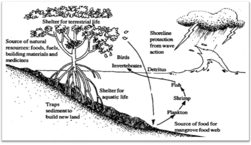
Figure 2. Schematic representation of the benefits of mangroves
Source: (CoastvsErosion, 2013)
In summary, the mangrove is an essential element in maintaining biodiversity of the
marine and coastal environment at global and local level. As stated by Chong (2005),
the mangrove ecosystem has several natural functions of great ecological and
economic importance, among which are highlight the following:
3.5.1 Fisheries
Mangrove forests accommodate large varieties of shrimps, crabs, fish and mollusc
species, which are the source of financial gain and food for thousands of coastal
communities around the world (WWF, n.d). However, according to African
Wetlands International (2017) and Lindén & Jernelöv (1980), the mangrove roots
and leaves that decay produce a significant amount of organic matter in this
environment which is released in the coastal waters in the form of debris, providing
nourishment to plankton which is the vital food needed for the survival of all marine
18
To cite an example, research conducted on the Mesoamerican reef proved that there
are as many as 25 times more fish on reefs near to mangrove forests in comparison to
the areas where mangrove deforestation has occurred (WWF, n.d). In addition,
roughly 80% of global fisheries come directly or indirectly from mangroves (Ellison,
2008). This shows how vital mangrove forests are to the coral reefs and their
production and for the benefit of production and commercial fisheries. According to
the USAID (2001) and ADF (2001), more than 40% of the protein consumed by the
Mozambican population is attained from fish. The same applies to Quelimane
District, where part of the local communities resort to fishing as part of their means
of survival.
For example, Icidua, one of Quelimane's neighbourhoods created entirely on
mangrove lands, today has more than 9,084 habitants (MuniSAM - Concern
Universal, 2013). Furthermore, from the survey conducted with 84 of the habitants of
the three neighbourhoods selected for the present research, namely Icidua, Chuabo
Dembe and Mirazane, 64% affirmed fishery in Quelimane as their daily principal
activities (Figure 3).
Figure 3. Main activities of the Population living on mangrove lands in Quelimane
Source: The author
64% 22%
8% 6%
19
3.5.2 Shoreline Protection
Mangrove forests provide coastal resilience, protecting shorelines from erosion
caused by natural events, such as storms, tsunamis, floods, hurricanes, winds and
waves from the ocean (CoastvsErosion, 2013; Wetlands International Africa (2012).
Their thick roots grow in an entangled form thus stabilizing sediments, which in turn
averts soil erosion.
Furthermore, the mangrove roots trap sediments from ashore and act as a filter from
harmful substances and maintaining the water clear and clean (Florida Museum, n.d).
In addition, as stated by Wetlands International Africa (2012), “a mangrove stand of
30 trees per 0.01 hectare with a depth of 100 m can reduce the destructive force of a
tsunami by up to 90%, and reduce wave height by as much as 66% over 100 m of
forest.” This means that having the mangrove ecosystem is synonymous with great protection against many of the destructive natural phenomena.
3.5.3 Shelter to Biodiversity
The estuaries are the areas with high amounts of nutrients and these nutrients are
supplied to the mangroves by water from rivers and the sea. Allied to this favoured
location, the mangrove vegetation has high productivity and is considered as the
main carbon source ecosystem (FAO, 1994; Lindén & Lundin, 1997). Therefore,
these areas of mangroves, rich in nutrients, become feeding grounds and shelter to
wildlife and marine species that occur in this environment, where mangroves act as
important maintainers of biological diversity (Lindén & Lundin, 1997; WWF n.d).
Further, according to Dugan (1993) cited by CoastvsErosion (2013; pp.1) "within the
mangrove forests, wildlife is abundant as at least 35 species of reptiles, 270 bird
species and 42 mammal species are native".
In summary, it can be said that the mangrove forests are an essential element in
maintaining biodiversity and protection of the marine and coastal environment at
global and local level. However, the destruction of this important ecosystem results
20
the environment, the economy and social well-being, as will be further developed in
21
CHAPTER IV
4.0 MANGROVE DEFORESTATION IN QUELIMANE DISTRICT
4.1 Current State of Mangrove Deforestation
There is little information recorded on the current status of mangrove deforestation in
Quelimane as no scientific study has been carried out to determine the estimated
amount of mangrove lost in this particular district. Therefore, current images display
the affected areas in Quelimane, especially the targeted areas Chuabo Dembe, Icidua,
and Mirazane.
4.2 Causes of Mangrove Deforestation in Quelimane
4.2.1 Rural Exodus
The Mozambican civil war, which began in 1977 and ended in 1992, immensely
affected the population’s sustainability, leaving long-lasting effects, especially in the
rural areas (DPTADER interview). According to local sources, the coastal areas
referenced above for this study initially were not inhabited.However, from the 1990s
onwards, mangrove lands were occupied by fishermen and shortly after began to
emerge settlements attracted by better survival conditions. Evidence shows a strong
relationship between poverty and the environment (Satterthwaite, 2003). The
ever-increasing population living under poverty in Quelimane District contributes a lot to
more accelerated environmental degradation, it being the main reason of the
22
4.2.2 Land for House Construction
The lands in Quelimane urban areas are costly, forcing new poor people and
migrants to invade the mangrove area to establish their dwellings. The massive
occupation of these spaces was done in a disorderly manner, culminating in the
destruction of mangroves and their biodiversity (Figure 4-8).
Figure 4. Part of Mangrove Areas Deforested for House Construction at Liberdade
Source: Picture taken by the author
Figure 5. Houses Built on Mangrove Lands at Mirazane
23
Figure 6. Houses on Mangrove land at Mirazane
Source: Picture taken by the author
Figure 7. Vast Areas of mangrove Deforested at Icidua
24
Figure 8. Houses on Mangrove Land at Chuabo- Dembe
Source: Picture taken by the author
The above images give us a qualitative impression of the current status of mangrove
land occupied by people from rural areas.
A survey was carried out with the local communities as part of this research, to
determine the initial period of mangrove devastation and the causes of resettlement
into mangrove land (Table 2).
Table 2. Period of mangrove Land Occupation in Quelimane
Period Nº of surveyed Percentage (%)
1990 – 1997 14 16%
1998 – 2005 20 24%
2006 – 2016 50 60%
25
The results of the survey show a significant increase in destruction of mangrove
areas for various purposes over the last 25 years. Residents of Quelimane District
point to factors such as available land to build new houses and easy access to the sea
resources.
Looking at the current situation that characterizes the main urban centers in
Quelimane, it is clear that the ecosystem of mangroves has been sacrificed to house a
large number of people. In addition to the above factors, as can be seen in Figure 9
below, the population inquired affirms that the main reasons of living on mangrove
land is due to lack of space, high cost for safer land and the need of living close to
the river.
Figure 9. Reasons for Mangrove Land Habitation
Source: The author
4.2.3 Source of Construction Material
The main product from mangrove trees is its wood which in Quelimane is mainly
used as construction material. Studies show that 70.5% of the population in
Zambezia Province live in poverty of which 93% are in the rural areas (Mercier, et
al, 2016). However, with such economic conditions and the high cost of construction
83% 10%
7%
26
materials, such as cement, concrete brick, sand and stones, the arriving and poor
populations resort to cutting mangrove trees and using its wood with clay sand to
build precarious houses for accommodation (Figure 10-14).
Figure 10. Construction of Precarious Houses at Liberdade Neighbourhood
Source: Miramar Notícias (2016)
Figure 11. Construction of Precarious House at Chuabo Dembe
27
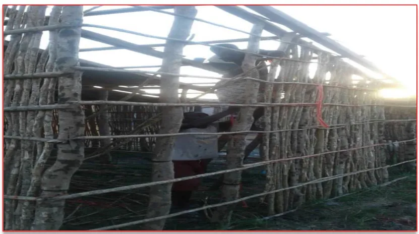
Figure 12. Mangrove Sticks in a Precarious House Construction at Mirazane
Source: Picture takem by the author
Figure 13. Houses Made with Mangrove Sticks and Clay Sand on Mangrove Lands
28
Figure 14. Various Houses on Mangrove Lands at Icidua
Source: Image taken by the author.
A study was conducted in 2007 by the National Statistical Institute - INE, to
determine the types of habitations and materials used for house construction in
Quelimane District. The results are shown in the table below (Table 3).
Table 3. Number of Houses in Quelimane According to Material Used
Type of Material
Quelimane District
Number of houses %
Concrete bricks 4,390 10.5
Ceramic bricks 1,110 2.7
Wood/Zinc 579 1.4
Clay bricks 379 0.9
Bamboo/palm sticks 8,528 20.04
Mangrove sticks and clay 26,379 63.1
Paper/plastic/sack/Tins 110 0.3
Others 329 0.8
Total 41,804 100
29
The above table presents the highest number of houses constructed, 26,379, which is
63.1% to be of sticks derived from mangrove and clay from mangrove lands. This
condition is observed along Quelimane coastline communities.
4.2.4 The Practice of Agriculture
Quelimane District has an estimated population of 475,000, where more than 60%
are uneducated and unemployed (INE, 2007). Therefore, the survey shows that the
majority of families practice annual subsistence farming of rice, sweet potatoes,
vegetables, cassava, beans and pumpkin among other types of crops. The agriculture
practiced by the communities has very little economic significance as most of the
produce is obtained for personal consumption and partly for commercial benefit.
However, some of the families residing in mangrove areas without fertile lands to
practice agriculture opt to cut mangrove trees or shrubs to clear an area and create
artificial barriers in the form of dunes around the land to impede the flowing of salt
sea water in the crop fields. With this technique, only rain waters the land, eventually
modifying its natural salinity in two or three rain seasons and making the land more
and more acceptable to growing some of the crops mentioned above (Image 15-17).
Figure 15. Mangrove Lands Converted Into Rice Field at Mirazane
30
Figure 16. Mangrove Lands Converted Into Rice Field at Chuabo Dembe
Source: Picture taken by the author
Figure 17. Part of Sweet Potatoes Field on Mangrove Land at Chuabo Dembe
31
4.2.5 Commercial and Energy Source
Since mangrove trees have various uses in the community of Quelimane district,
large areas of mangroves are cut for commercial purpose. Many cut mangrove trees
to sell the sticks as a means of income (Image 18-21).
Figure 18. Mangrove Sticks on Sale at Mirazane Market
Source: Image taken by the author
Figure 19. Mangrove Sticks on Sale at Mirazane
32
Figure 20. Mangrove Sticks on Sale at Icidua Market
Source: Picture taken by the author
Figure 21. Mangrove Sticks on Sale at Icidua
33
Furthermore, Mozambicans in general, depend on biomass energy for domestic
consumption. Apart from selling sticks, it is observed in Quelimane’s coastal
communities that mangrove trees are burned to produce charcoal both for domestic
and commercial use (Figure 22, 23). Even in urban areas, it is noted that charcoal
from wood remains the main source of energy for most of the population living in the
cities, as the cost of electricity is high.
Figure 22. Charcoal from the Burning of Mangrove Trees on Sale at Mirazane
34
Figure 23. Charcoal from the Burning of Mangrove Trees on Sale at Manjante
Source: Picture taken by the author
4.2.6 Land for Aquaculture
The practice of coastal aquaculture has been increasing throughout the years
worldwide and the ever-expanding aquaculture farms have led to the destruction of
mangroves in a large scale all over the world (Pattanaik & Prasad, 2011).
Speaking of Mozambique, Lindén and Lundin (1997, pp 54), stated that “with the
development of shrimp aquaculture, a new threat to mangrove ecosystems may arise
when large areas are cleared for aquaculture ponds”. This situation is clearly noted in
Quelimane District whereby part of the mangrove ecosystem has been converted into
aquaculture tanks, in which is practiced mainly for the production of Tilapia fish,
various species of prawns and clams.
According to AQUAPESCA, the only aquaculture company in Quelimane, their
farming tanks covers an area of 350 ha (AQUAPESCA, received by email). The
aquaculture tanks, as seen in pictures below, were built on mangrove lands, thus
35
Figure 24. Location of AQUAPESCA Company and its Tanks
Source: AQUAPESCA Company (Received by email)
Figure 25. Aquaculture Ponds on Mangrove Land
36
Figure 26. Aquaculture Ponds of AQUAPESCA on Deforested Mangrove Areas
Source: Picture taken by the author
Figure 27. AQUAPESCA Ponds for Aquaculture on Mangrove lands
37
As evidenced by the above images, the aquatic tanks were situated on mangrove
lands, thus meaning the destruction of a vast area of mangroves.
Indeed, although no studies have been performed to determine the exact amount of
area of mangrove deforested annually or in its entirety by the practices described
above, the reality as seen, is that large areas of mangrove in Quelimane District have
been destroyed and continues to be reduced by the day, with the knowledge of the
local authorities (DPTADERZ questionnaire; DPMAIPZ questionnaire).
However, to the detriment of the benefits mangroves bestow on the global and local
environment, the precarious constructions, disordered in an unclean environment,
carry with them risks and damage the lives of hundreds of citizens each year. The
author's knowledge about the district and his visits to the neighbourhoods that
emerged on mangrove lands helped him to relate the occupation and use of mangrove
resources to the poor. This means that the neighbourhoods on mangrove lands in the
district of Quelimane are the poorest, and the most prone to diseases such as malaria,
cholera among others.
The Mozambican Government has, however, already taken important steps in the
creation and implementation of national laws and institutions aimed at the
environment, which in part focus on the preservation and rational management of the
mangrove, as explained below:
4.3 Implementation and Enforcement of National Environmental Laws Related to Mangrove Ecosystem
4.3.1 Implementation - Political and Strategic Framework
In Mozambique, the management and conservation of mangrove forests is regulated
by a set of legal provisions as shown below in the tables 4 and 5, whereby it is listed
the main political strategies that guide the institutions and establish their legal
38
The Policy and Strategy of Forestry and Wildlife Development, establishes the
manner of conservation and the types of management plans for the sustenance and
utilization of natural resources with regular and permanent involvement of
communities (Resolution 8/1997 of 1 April).
Table 4. Political and Strategic Framework Applicable to the Management of Mangrove Ecosystem
Policy / Strategy Incidence on Mangroves
National Policy of Environment (Resolution n° 5/1995, of 3 August).
The policy recognizes the need to harmonize sustainable economic development by reducing the impact on the environment. Among the various strategies and priorities for actions that contribute to this vision. is to emphasize the need to strengthen institutional capacity for environmental management, decentralization, coordination, documentation, information and environmental research in regard to fisheries, the environment and conservation areas. National Land Policy
(Resolution n° 10/1995, of 17 October).
The policy acknowledges the need to promote economic and human development by ensuring the rights to usage and ownership of land by the population as investors, and also the preservation and management of important ecological areas (e.g. coastal areas with high biodiversity)
Policy and Strategy Development for Forests and Fauna Bravia (Resolution 8/1997 of 17 October.
The policy focuses on the monitoring and establishment of management plans and conservation; defining roles for the local NGOs, communities state for the proper management of mangrove forest resources.
Policy and conservation Strategy for
Implementation (Resolution 63/2009 2 November.
The policy aims to promote the technical and financial capacity for conservation by establishing a network of representative areas and appropriate conservation needs and creating instruments to reinforce fundraising strategies and improve local benefits.
Policy monitoring, Control and supervision and strategy
Implementation (Resolution 36/2008, 17 September).
The policy aims to improve monitoring, controlling and surveillance of fishing (e.g. industrial fishing, semi-industrial fishing, subsistence fishing, recreational and exploratory fishing and research) and environmental protection of marine and coastal species.
39
4.3.2 Implementation - Legal Framework
The Mozambican legislation related to mangrove forests management was adapted
from regional and international procedures and adopted into national laws and
regulations (Pereira et al, 2014). Table 5 below presents the foremost laws and
regulations for the sustainable management, protection and conservation of
mangrove forests implemented at national level.
Table 5. National Legal Framework for Mangrove Ecosystem Management
Legal Instruments Incidence on Mangroves
Constitution of the Republic of Mozambique (BR I serie-n⁰ 51, 22 December, 2004).
All citizens have the duty to defend and preserve the environment. They have the right to live in a balanced environment, whereby the state is the one that ensures the ecological balance and conservation of the environment through policies, environmental education and awareness to the sustainability and utilization of natural resources.
Environment Law (Law 20/1997, of 1 October.
Prohibits pollution and all activities that accelerate erosion, deforestation or any form of environmental degradation, especially that endanger species. It also prohibits the implantation of infrastructures with negative impact on the coastal environment and requires the completion of Environmental Impact Assessment-EIA, for environmental licensing purposes. The law defines the coastal zone and wetlands, in this case the mangrove forests as sensitive areas. Regulation of the Environmental
Impact Assessment Process (Decree 54/2015, of December 31 repeals Decree 45/2004 of 29 September).
40
mangroves. The A category of activities are activities that take place in ecosystems with special protected status, such as mangrove areas, small islands and erosion zones.
Prevention of Pollution Regulation and Protection of the Marine and Coastal Environment (Decree 45/2006, of 30 November).
This regulation prohibits environmental pollution by chemicals or waste, especially in fragile ecosystems. It also establishes legal standards for the protection and conservation of such areas, specifically addressing wetlands, prohibiting the discharge of untreated effluent, introduction of exotic species, uncontrolled burning and forest exploitation.
Law of Land (Law 19/1997 of 1 October)
Considers mangroves areas as partial protected zone (the strip of coastline and outline of islands, bays and estuaries, the measured line of high tides maximum up to 100 meters into the territory). Further, it establishes that in the partial protected zones, there are no rights to usage, otherwise for any type of activity on the land and City Council or Provincial Governments require special permission. This law protects forms of customary utilization of resources by the communities.
Law of Forestry and Wildlife (Law 10/1999, of July 7).
41
Regulation of the Forestry and Wildlife Law (Decree 12/2002 of 6 June.
List species of mangrove as 3rd class wood producers, namely: Avicennia, Barringtonia recemosa, Bruguiera gymnorhiza, Ceriops tagal, Heritiera littoralis and Rhyzophora mucronata (which should be protected and managed in a sustainable way).
Law of Fisheries (Law 22/2013, of November 01).
Applied for management and administration of the various fishing practices, including small-scale fishing, subsistence fishing, and aquaculture, among others. The Law of Fisheries, article 63 prohibits the destruction of mangroves for the establishment of aquaculture infrastructures. It allows only the construction of water pumping stations, water intake channels for fixed installations on land and anchorages for crop species whose habitat is mangrove, and require replacement of mangroves destroyed during the technical and EIAs studies.
General Regulations for Aquaculture (Decree 35/2001, of 13 November).
Prohibits the transformation of mangrove lands for the installation of aquaculture facilities; or obligation to compensate by replacing in another area.
Law of Territorial Planning (Law 18/1997, of 18 July).
This law aims to the organization of the national territory and the sustainable use of natural resources, including also, among other objectives the preservation of ecological balance between the needs of the community and the protection of fragile ecosystems, such mangrove forests, coastal areas and the seafront. Law of Conservation (Law 16/2014, of
18 July).
The Law aims to the application of principles and rules for the management, protection, conservation, restoration and sustainable use of biodiversity within conservation areas, including the requirements for a participative management, financing mechanisms, and categorization of protected areas.
42
4.3.3 Implementation - National Institutions Related to Mangroves
4.3.3.1 Ministry of Land, Environment and Rural Development
In Mozambique, the administration, conservation and protection of mangrove forests
is in the care of the Ministry of Land, Environment and Rural Development -
MITADER. The ministry monitors, plans and coordinates environmental issues
including the implementation of polices and laws for conservation, sustainable use
and rural development (Presidential Decree n° 13/2015, of March 16; Resolution n°
5/2015, of 26 June).
The MITADER, through the National Forestry Directorate, is responsible for the
issuing of licenses, protection, supervision, conservation and management of forests
and the monitoring of consumption by communities (Presidential Decree n° 13/2015,
of 16 March). The MITADER has its provincial branches, which, among other tasks,
are responsible for issues related to management, protection and conservation of
mangrove forests. Therefore, for each district, the responsibility is in the care of the
District Services of Planning and Infrastructure - SDPI, while in municipal areas, the
responsibility lies in the hands of the local municipality. In addition, for the areas
beyond the urban lands, the management strategy consists of both the participation of
authorities and the local communities (Resolution n° 8/97, of 1 April).
4.3.3.2 National Administration of Conservative Areas
The administration and conservation of mangroves is the responsibility of the
National Administration of Conservation Areas – ANAC, because the Mozambican
law of lands and decree n° 45/2006, of November 30, considers mangrove
ecosystems as a zone of partial protection and fragile ecosystem. ANAC works under
the supervision of MITADER (MITADER, 2015). ANAC aims for the conservation
of biodiversity and its sustainability thus ensuring the well functioning of
ecosystems, monitoring and research on the natural resources (Decree n° 9/2013, of