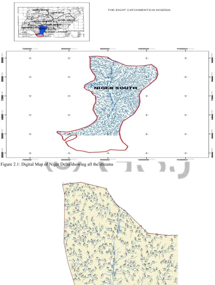
GSJ: Volume 8, Issue 1, January 2020, Online: ISSN 2320-9186
www.globalscientificjournal.com
APPLICATION
OF
MORPHOMETRIC
PARAMETERS
FOR
EVALUATION
OF
STREAM
FLOW
CHARACTERISTIC
AT
THE
LOWER
NIGER
RIVER
Authors
Yarima Ladan Chris,Adebayo W. Salami, Samaila Kunden Ishaya
Address: T6 J.D O’connel road near fire service Headquarters, Commissioner Quarters, GRA, Minna, Niger state, Nigeria,
Phone: +2348094912569, +2347012450818
1. Department of geography, Nasarawa State University, Keffi, Nigeria
2. Department of Water Resources and Environmental Engineering, University of Ilorin 3. Department of geography, Nasarawa State University, Keffi, Nigeria
Abstract
The study on the geomorphology of the basin’s morphometric attributes for an evaluation of stream flow characteristic at the lower Niger river was achieved by the delineation of the watershed, and determination of morphometric parameters aided by the Geographical Information System. The results of analysis of the Niger Delta geomorphological attributes showed that the watershed has a low relief and elongated shape. The drainage network is dendritic type, indicating homogeneity in texture and requiring less structural controls. This provides inferences on the terrain parameters such as the nature of the bedrock, infiltration capacity, groundwater recharge, runoff prediction and soil erosion. A low drainage density, drainage texture, and stream frequency was observed, which indicate a coarse subsurface formation and permeability rate. Other observed parameters such as low overland flow, low relief and elongation shape of the catchment revealed recharge related measures, surface water augmentation measures that can be undertaken for water resource management and soil conservation structures in the study area.
Key words
GSJ© 2020
1.0 Introduction
The demand for water has increased over the years making the assessment of the quantity and the quality of water resources and its optimal utilization most critical. Identification of ground features such as geological structures, geomorphic features and their link to hydrological characteristics may serve as direct or indirect indicators of ground and surface water potential of an area. The geomorphic conditions are essential prerequisites in understanding the water bearing characteristics of hard rocks and drainages patterns. The function of rocks types and geologic structures in the development of stream networks can be better understood by studying the nature and type of drainage patterns and by a quantitative morphometric analysis. Morphometric parameters are a set of numerical factors that define a watershed. Watershed morphometric parameters are reflective of its hydrological response and can be helpful in synthesizing hydrological behaviour and water balance. A quantitative morphometric characterization and analysis of a watershed is considered to be the most satisfactory method for proper watershed management planning and implementation of soil and water conservation measures. The characterization of geomorphic attribute enables us to understand the relationship among different aspects of the basin’s drainage pattern and also enables a comparative evaluation of different drainage basins developed in various geologic and climatic regimes (Sreedevi, 2013).
Surface hydrological indications are promising scientific tools for assessment and management of water resources. Drainage morphometric analyses are a prerequisite for selection of water recharge sites, watershed modeling, runoff modeling, watershed delineation, groundwater prospect mapping and geotechnical investigation (Magesh, 2011; Thomas, 2012; Javed, 2009).
The drainage network analysis is generally performed using the prevailing geological variation, topographic information and structural set of a basin and their interrelationships. Remote sensing and Geographical Information System (GIS) based drainage basin evaluation has been conducted by various researchers for different terrains. This analysis is confirmed to be a very scientific tool for generation of precise and updated information for characterization of drainage basin parameters (Grohmann, 2004).
2.0 Material and Methods
The evaluation of the stream flow was based on the integrated use of remote sensing and GIS technique. The remotely sensed data is geometrically rectified and the digitization of dendritic drainage pattern is carried out in Arc GIS 10.1 software. For stream ordering, Horton’s law is followed by designating an un-branched stream as first order stream, when two first order streams join it is designated as second order. Two second order steams join together to form third order and so on. The number of streams of each order are counted and recorded. The drainage map along with basin boundaries are digitized as a line coverage giving unique identity for each order of stream. The digitized map is edited, and saved as line coverage in Arcview GIS Software. Morphometric parameters under linear and shapes are computed using standard methods and formulae (Waika, 2014).The fundamental parameter namely; stream length, area, perimeter, number of streams and basin length are derived from drainage layer. The values of morphometric parameters namely; stream length, bifurcation ratio, drainage density; stream frequency, form factor, texture ratio, elongation ratio, circularity ratio and compactness constant are calculated based on the formulae suggested by Waika (2014). Although for the peculiarity of Niger Delta which is lengthy with a less proportionate axial width, circularity ratio was calculated using the axial width (Wb) as the diameter of the basin. A factor of 10 was used to multiply both the obtained values of elongation and circularity ratios.
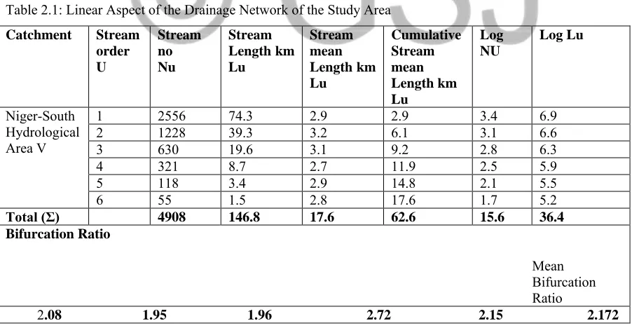
Figure 2.1: Digital Map of Niger Delta showing all the streams
GSJ© 2020
2.1 Study Area
The Niger Delta receives the lower Niger river in the Niger South catchment in Nigeria, between the longitude 6oE and latitude 8o36'N North West, longitude7°37.8'E and latitude7o37.2'Nnortheast, longitude5°26.4'E
and latitude50 6’N southwest, longitude7°0.6'E and latitude4o25.8'Nsoutheast. The Lower Niger River and the Niger
Delta hydrographical region of the Niger River Basin is approximately the Hydrological area 5 (HA5) in Nigeria. States in the hydrological area include Delta, Rivers, Bayelsa, parts of Edo, Anambra and Kogi States.
Vegetation in the project area can be classified into four types. Namely: the Guinea Savannah, Tropical Rainforest, Fresh water Swamp and the Salt water Swamp.
The catchment is part of the rain forest belt, stretches all the way across the southern parts of the country, from east to west and covers the greater parts of Ogun, Ondo, Southern Edo, Delta, Imo, Akwa-Ibom and southern Cross River states.
The climate of the Niger South Catchment is characterized by a long rainy season from March- April through October-November. The precipitation increases from the north of the catchment (with an average of 1,500 mm around Lokoja) to the coastal area of the Niger Delta where mean annual rainfall averages around 4,000 mm, making it one of the wettest areas in Africa.
The soils of the Niger South Catchment fall into three zones- (a) interior zone of laterite soils (parts of Kogi State), (b) zone of alluvial soils (parts of Kogi, Edo, Delta, Anambra, Bayelsa, and Rivers States, and (c) southern belt of forest soils (parts of Edo, Delta, Anambra, Bayelsa, and Rivers States).The soils are all of fluviatile origin, except for the Coastal Barrier Islands that consist of marine sand overlain with an organic surface layer.
For many communities in the Niger South Catchment, erosion and the associated flooding constitute serious environmental hazards. Erosion caused by water is predominant in the Catchment. Different types of erosions, such as sheet, rill, and gully, are pervasive in Anambra and Edo States, and to a lesser extent in Kogi State.
2.2 Data Analysis
The data obtained were collated and presented in Table 2.1 and 2.2 for linear aspect of the drainage network and Aerial aspects respectively. The table contains information on morphometric parameters comprising the area properties of the drainage basin are computed, forming the basis of analysis of the basin stream flow.
Table 2.1: Linear Aspect of the Drainage Network of the Study Area
Catchment Stream order U Stream no Nu Stream Length km Lu Stream mean Length km Lu Cumulative Stream mean Length km Lu Log NU Log Lu Niger-South Hydrological Area V
1 2556 74.3 2.9 2.9 3.4 6.9
2 1228 39.3 3.2 6.1 3.1 6.6
3 630 19.6 3.1 9.2 2.8 6.3
4 321 8.7 2.7 11.9 2.5 5.9
5 118 3.4 2.9 14.8 2.1 5.5
6 55 1.5 2.8 17.6 1.7 5.2
Total (Σ) 4908 146.8 17.6 62.6 15.6 36.4 Bifurcation Ratio
Mean Bifurcation
Ratio
Table 2.2: Aerial Aspects of the Study Area
Morphometric Parameters Symbol/Formula Result
Area (km2) A 496.8
Area (km2) ᴫr2 498.8
Perimeter (km) Pb 1470.7
Circumference (km) Pc=2ᴫr 79.2
Basin Length (km) Lb 387.2
Axial width (km) Wb 125.2
Slope (S) S = E/L 1.29
Drainage density (km/km2) Dd= ΣLu/A 0.3
Constant channel maintenance(C) 1/Dd 3.3
Overland flow LO 1/2Dd 1.7
Infiltration number DdxFs 2.97
Elongation ratio Re= 2R/ Lb 0.07
Circularity ratio Rc = A/ᴫr2 0.9
Compactness coefficient Cc Pb/Pc 18.6
Form Factor ratio F = 𝐴
𝐿𝑏2 0.003
Drainage Texture Dt=ΣNu/P 3.3
Drainage frequency Fs =Σ Nu/A 9.9
Main channel 194.9
Total stream length (km) 146.80
3.0 Results and Discussion
3.1 Linear Aspects
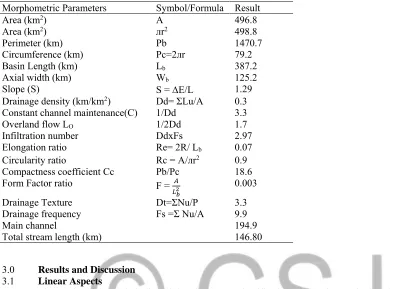
The results of the study indicated that the pattern classification of the Niger Delta is a dendritic type, which is characterized by homogenous subsurface strata. The stream order of the Niger Delta varies from first orders to sixth orders. Large number of stream was found in the first and second orders. As the stream order increases the total number of streams decreases (table 2.1). The drainage map with stream order of the Niger Delta is shown in figure 2.1 and 2.2 respectively. Stream ordering of the hydrological area was computed using ArcGIS 10.1 software by applying the methods proposed by Horton (1945) cited in (Tesfaye, 2015). The change in stream orders may indicate flowing of streams from high altitude and the physical characteristics of rock variations. The understanding of streams in a drainage system constitutes the drainage pattern, which in turn replicates mainly structural or lithologic controls of the underlying rocks. The Niger Delta has a classification of dendritic drainage patterns, characterized by a treelike branching system or dendritic arrangements of small streams or tributaries in the headwaters (branches) that flow in a variety of directions, continually joining larger streams, eventually forming a “major” stream or river.
The connection between the bifurcation ratio and the stream length ratio is determined by hydrogeologic, physiographic and geological characteristics. The values of total length, mean length and length ratio of the diverse stream orders of the area are shown in table 2.1. Stream length and their ratio are very important parameters to scan the hydrological characteristics of the river basin because they characterize the permeability of the rock formations in a basin. It also indicates if there is a major change in the hydrological characteristics of the underlying rock surfaces within the basin (Singh, 2013).
GSJ© 2020 3.2 Areal Aspects
The low drainage density of 0.3 indicates towards a very coarse drainage pattern with sub-humid climate of the study area. The coarse texture gives more time for the infiltration of overland flow and hence to groundwater recharge. A low value of the drainage density indicates a relatively low density of streams and thus a slow stream response to runoff Singh, (2004), Pingale, (2012) as cited in Tasfaye (2015). Drainage density has classified into five different textures. A drainage density less than 2 indicates “very coarse”, between 2 and 4 is “coarse”, between 4 and 6 is “moderate”, between 6 and 8 is “fine” and greater than 8 is “very fine” drainage texture Smith, (1950) as presented in Tasfaye (2015). The Niger Delta has a drainage texture of 3.3 which indicates the very coarse drainage texture. Similarly, the very coarse drainage texture indicates the presence of permeable material with low relief. The variation of the values of drainage texture depends upon a number of natural factors such as climate, vegetation, rock type, soil type and their infiltration capacity and relief of the basin. Low drainage density results from permeable subsurface material, vegetation cover and relief results in good infiltration capacity. High drainage density results from weak or impermeable subsurface material, thin vegetation and mountainous relief (Singh, 2013). The drainage frequency of 9.9 indicates a positive correlation with the Niger Delta drainage density suggesting that an increase in stream population occurs with respect to increase in drainage density. The low stream frequencies value indicates sparse drainage network favouring groundwater recharge. The calculated elongation ratio of 0.65 suggests that the basin belongs to the elongated type shape basin and low relief. The values of elongation ratio (Re) generally vary from 0.6 to 1.0 over a wide variety of climatic, topography and geologic conditions Pankaj, (2009) as cited in Tasfaye (2015). The values close to 1.0 are typical of regions of very low relief, whereas values in the range 0.6 to 0.8 are usually associated with high relief and steep surface slope. The 0.65 value obtained for Niger Delta indicates that the study area is of moderate relief category. These values can be grouped into three categories: 1) circular (>0.9); 2) oval (0.9 to 0.8); 3) elongated (<0.7) Strahler, A.N. (1964) as presented in Tasfaye (2015). The circularity ratio of the Niger Delta is 0.4. Circularity ratios range 0.4 to 0.5 indicates strongly elongated and extremely permeable homogenous geologic materials. The result of circularity ratio of the Niger Delta indicates that the basin is strongly elongated in shape, moderate runoff discharge and permeable subsoil circumstances. It is influenced by the frequency and length of streams, geological structures, land use/land cover, climate, relief and slope of the watershed Miller, (1953) as cited in Tasfaye (2015). The calculated Form factor value of 0.003 suggests that the shape of the basin is elongated. The elongated Niger Delta with low Form factor indicates that the basin will have a flatter peak of flow for longer duration and conducive for more groundwater recharge. The Form factor indicates the flow intensity of a basin for a defined area. Watersheds with high Form factors experience larger peak flows of shorter duration, indicating less contact time and less infiltration whereas elongated watershed with low form factors experience lower peak flows of longer duration. A perfectly circular watershed have Form factor value of >0.78 Sharkh, (2009) as presented inTasfaye (2015). The shorter length of overland flow the quicker surface runoff will enter the stream. In the present study the length of overland flow is 1.7 which indicates that there is less structural disturbance, less runoff conditions and having moderate overland flow. A larger value of length of overland flow indicates longer flow path and thus, gentler slopes. The length of overland flow is the most important variables affecting terrain development of drainage basin. The length of overland flow is mostly influenced by both hydrologic and physiographic structures of the area. The overland flow is related inversely to the average slope of streams and it is directly equal to the reciprocal of drainage density Horton, (1945) as cited in Tasfaye (2015),Kaliraj, (2014). The Constant of channel maintenance (C) is the inverse of drainage density. The value is indicative of the area needed to maintain 1km length of stream, i.e a quantitative expression of the minimum limiting area required for the development of a length of channel. The Constant of channel maintenance of 3.3 means on an average 3.3km2 surface area is needed in the watershed for the creation of
one linear km of stream channel Waikar, (2014). This value indicates that a large area is required for stream development.
When a watershed is a perfect circle, the Compactness coefficient (Cc) will equal to 1. The closer a compactness coefficient is to 1, the greater the likelihood that precipitation will be quickly concentrated in the main channel, resulting in peak flows (Avery, 1975) as cited in Rymbai (2012). The compactness coefficient of the studied basin is found to be higher than unity (18.6) which suggests that the shape of the basin is elongated (Table 3.2).
The infiltration number (If) of a watershed is defined as the product of drainage density and stream frequency and given an idea about the infiltration characteristics of the watershed. The
value indicates a positive correlation to the obtained values of drainage density, drainage frequency, and drainage texture.
3.3 Relief Aspects
The relief ratio (Rh) value of 1.29 indicated that the major portion of the catchment is having a gentle slope (Table 2.2). It measures the overall steepness of the hydrological area and is an indicator of the intensity of the soil erosion processes operation on the watershed’s slope. The high value of relief ratio is characteristics of hilly areas with high runoff production and soil erosion.
4.0 Conclusion
GSJ© 2020
REFERENCES
Adegoke, K.M. Bulus L. G. 2015, Hydrological and Morphometric Analysis of Upper Yedzaram Catchment of Mubi in Adamawa State, Nigeria. Using Geographic Information System (GIS), http://journal.sapub.org/env
Ajibade, L.T Ifabiyi, L.P (2010) Morphometric Analysis of Ogunpa; published by Ethiopian Journal of Environmental Studies and Management (EJESM) Vol.3 No.1
Atrayee Biswas, (2014) Morphometry Governs the Dynamics of a Drainage Basin: Analysis and Implications,
Geography Journal
Volume 2014, Article ID 927176, 14 pages
http://dx.doi.org/10.1155/2014/927176
Babita Pal, Sailesh Samanta and Pal, D. K. (2012), Morphometric And Hydrological Analysis And Mapping For Watut Watershed Using Remote Sensing And Gis Techniques, https//:www.researchgate.net Eze B.E & Joel Efiong, 2010, Morphometric Parameters of the Calabar River Basin: Implication for Hydrologic
Processes, [email protected]
Faith Ekong, 2012, Water Resource Management in the Niger Delta Region of Nigeria: The Role of Physical Planning, [email protected]
Farrukh Altaf (2013), Morphometric Analysis to Infer Hydrological Behaviour of Lidder Watershed, Western Himalaya, India, http://dx.doi.org/10.1155/2013/178021
Jimoh, H.I Ajao .L, 2009, Niger Drainage Density and Stream-flow Charles W. Carlston Physiographic and Hydraulic Studies of Rivers, 1963, C3
Javed, A., Khanday, M.Y. and Ahmed, R. (2009) Prioritization of Sub-Watersheds Based on Morphometric and Land Use Analysis Using Remote Sensing and GIS Techniques. Journal of Indian Society of Remote Sensing, 37, 261-274. http://dx.doi.org/10.1007/s12524-009-0016-8
Jha, M.K, Chowdhury, A., Chowdary, V.M. and Peiffer, S. (2007) Groundwater Management and Development by Integrated RS and GIS: Prospects and Constraints. Water Resource Management, 21, 427-467.
http://dx.doi.org/10.1007/s11269-006-9024-4
Kuldeep Pareta, 2011, Quantitative Morphometric Analysis of a Watershed of Yamuna Basin, India using ASTER (DEM) Data and GIS, [email protected]
Lambert, David, (1998), The Field Guide to Geology. Checkmark Books, pp. 130131.ISBN0-8160-3823,
https://en.wikipedia.org/wiki/Drainage_system_(geomorphology)
Liaqat, A.K.R. and Alia, Y. (2013) Morphometric Analysis for Soil Erosion Assessment in Parts of Chambal Basin Using Remote Sensing and GIS, Madhya Pradesh. International Journal of Advanced Technology & Engineering Research, 3, 134-141
Waikar, M.L. and Aditya P. N, (2014) Morphometric Analysis of a Drainage Basin Using Geographical Information System, http://ijmcr.com
Kaur, M. (2014), Quantitative Geomorphological Analysis & Land Use/ Land Cover Change Detection Of Two Sub-Watersheds In Ne Region Of Punjab,India.www.int-arch-photogramm-remote-sens-spatial-inf-sci.net/.../2014/isprsa
PSE Consultants Limited, (2011), Niger South Integrated Water Resources Management & Water Efficiency Plan, journal.unaab.edu.ng
Prafull Singh, Ankit Gupta, Madhulika Singh, (2014) Hydrological inferences from watershed analysis for water resource management using remote sensing and GIS techniques, www.elsevier.com/locate/ejrs
Sarita Gajbhiye. Mishra, S. K. Ashish Pande, (2013), prioritizing erosion-prone area through morphometric analysis: an RS and GIS perspective, [email protected]
Singh, A., Nestmann, K., Franz and Eldho, T.I. (2004) Estimating Hydrological Parameters for Anas Catchment from Watershed Characteristics. Proceedings of the International Conference on Advanced Modeling Technique for Sustainable Management of Water Resources, Warangal, 28-30 January