https://doi.org/10.5194/essd-9-461-2017 © Author(s) 2017. This work is distributed under the Creative Commons Attribution 3.0 License.
Seabed images from Southern Ocean shelf regions off
the northern Antarctic Peninsula and in the southeastern
Weddell Sea
Dieter Piepenburg1,2, Alexander Buschmann1, Amelie Driemel1, Hannes Grobe1, Julian Gutt1,
Stefanie Schumacher1, Alexandra Segelken-Voigt1,3, and Rainer Sieger1
1Alfred Wegener Institute, Helmholtz Centre for Polar and Marine Research Bremerhaven,
Am Handelshafen 12, 26570 Bremerhaven, Germany
2Helmholtz Institute for Functional Marine Biodiversity at the University of Oldenburg (HIFMB),
Carl-von-Ossietzky-Str. 9–11, 26129 Oldenburg, Germany
3Carl von Ossietzky University of Oldenburg, Ammerländer Heerstraße 114–118, 26129 Oldenburg, Germany
Correspondence to:Dieter Piepenburg (dieter.piepenburg@awi.de) Received: 3 March 2017 – Discussion started: 24 March 2017 Revised: 28 May 2017 – Accepted: 14 June 2017 – Published: 21 July 2017
Abstract. Recent advances in underwater imaging technology allow for the gathering of invaluable scientific information on seafloor ecosystems, such as direct in situ views of seabed habitats and quantitative data on the composition, diversity, abundance, and distribution of epibenthic fauna. The imaging approach has been extensively used within the research project DynAMo (Dynamics of Antarctic Marine Shelf Ecosystems) at the Alfred Wegener Institute, Helmholtz Centre for Polar and Marine Research Bremerhaven (AWI), which aimed to comparatively assess the pace and quality of the dynamics of Southern Ocean benthos. Within this framework, epibenthic spatial distribution patterns have been comparatively investigated in two regions in the Atlantic sector of the Southern Ocean: the shelf areas off the northern tip of the Antarctic Peninsula, representing a region with above-average warming of surface waters and sea-ice reduction, and the shelves of the eastern Weddell Sea as an example of a stable high-Antarctic marine environment that is not (yet) affected by climate change. The AWI Ocean Floor Observation System (OFOS) was used to collect seabed imagery during two cruises
of the German research vessel Polarstern, ANT-XXIX/3 (PS81) to the Antarctic Peninsula from January to
March 2013 and ANT-XXXI/2 (PS96) to the Weddell Sea from December 2015 to February 2016. Here, we report on the image and data collections gathered during these cruises. During PS81, OFOS was successfully deployed at a total of 31 stations at water depths between 29 and 784 m. At most stations, series of 500 to
530 pictures (>15 000 in total, each depicting a seabed area of approximately 3.45 m2or 2.3×1.5 m) were
462 D. Piepenburg et al.: Seabed images from Southern Ocean shelf regions
1 Introduction
The research project Dynamics of Antarctic Marine Shelf Ecosystems (DynAMo) at the Alfred Wegener Institute, Helmholtz Centre for Polar and Marine Research Bremer-haven (AWI) aimed to comparatively assess the pace and quality of the dynamics in Southern Ocean benthos and en-dotherms. It is a contribution to the international scientific research program Antarctic Thresholds – Ecosystem Re-silience and Adaptation (AnT-ERA) of the Scientific Com-mittee on Antarctic Research (SCAR). By applying a com-parative field study approach, the geographical focus of Dy-nAMo was on an area with above-average warming of sur-face waters and sea-ice reduction around the tip of the Antarctic Peninsula (Gutt, 2013; Gutt et al., 2016) and a sta-ble high-Antarctic marine environment that is not (yet) af-fected by climate change in the southeastern Weddell Sea (Schröder, 2016).
Special emphasis has been on the study of the spatial dis-tribution patterns of shelf megabenthic epifauna. Accord-ing to an often-used pragmatic definition proposed by Gage and Tyler (1991), this seabed community fraction is com-prised of all organisms that are large enough to be visible in seabed images and/or to be caught by towed sampling gear (i.e., organisms with body sizes larger than approxi-mately 1 cm). They are of ecological significance for South-ern Ocean shelf ecosystems (Gutt, 2006), as they affect the small-scale topography of seafloor habitats and hence the structure of the entire benthic community (Gili et al., 2006). In addition, some megabenthic species are sensitive to envi-ronmental change due to their slow growth, specific repro-duction mode, high degree of environmental adaptation, and narrow physiological tolerances, and can thus serve as early indicators of ecosystem shifts in response to environmental change (Barnes et al., 2009).
Based on several investigations performed during
previ-ous cruises of the German research vesselPolarsternto the
Antarctic Peninsula and the Weddell Sea, we carried out comparative follow-up field studies in the austral summers of 2013 and 2015–2016. The main objectives were the fol-lowing:
– to complement surveys of mega-epibenthic assemblages
on the shelf off the northern Antarctic Peninsula (cruise PS81 2013) and the southeastern Weddell Sea (cruise PS96 2015–2016), providing further data that are com-parable with those obtained in earlier studies in these regions (Biebow et al., 2014);
– to identify the spatial distribution patterns of epibenthic
megafauna across multiple spatial scales (10 m, 100 m, 10 km, and 100 km);
– and to contribute to the standardization of the
classifica-tion of Antarctic megabenthic communities (Gutt, 2007, 2013).
Seabed images are used for different purposes. These include (1) assessing the large epibenthos as a whole, (2) carrying out quantitative community and diversity analyses, (3) includ-ing environmentally relevant (e.g., CTD data if CTD sensors are integrated in OFOS) and visible seabed parameters (e.g., the amount of gravel and debris and the number of ripple marks) at exactly the same spots from which the biological information originates, (4) allowing for analyses with high spatial resolution (patterns within and between adjacent pho-tographs, e.g., to survey the impact of iceberg scouring), and (5) acquiring information on biological interactions, such as epibiotic life mode.
2 Material and methods
2.1 AWI Ocean Floor Observation System
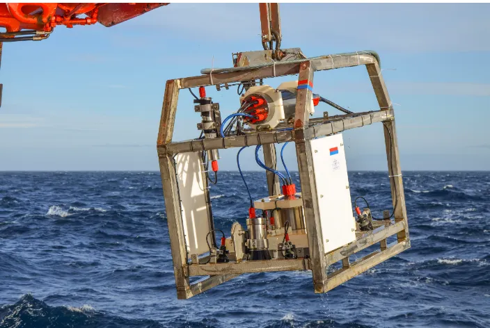
The AWI Ocean Floor Observation System (OFOS) was used for seabed imaging surveys along drift profiles (transects) to investigate the epibenthic megafauna and its seafloor habi-tats. The setup and mode of deployment for OFOS was similar to that described by Bergmann and Klages (2012). OFOS is surface-powered gear (Fig. 1) equipped with two downward-looking cameras installed side by side: a
high-resolution, wide-angle still camera (Canon®EOS 5D Mark
III with EF 24 f/1.4L II lens, f-stop 13, exposure time
1/125 s, in-air view angles 74◦horizontal, 53◦vertical, and
84◦diagonal, image size 5760×3840 px=21 Mpx; front of
pressure-resistant camera housing consists of plexiglas dome port) and (only in 2015–2016) a high-definition color video
camera (Sony® FCB-H11). During cruise PS81, OFOS did
not yet include the video camera.
The system was vertically lowered over either the star-board side (PS81) or the stern of the ship (PS96) with a broadband fiber-optic cable until it hovered approximately 1.5 m above the seabed. It was then towed after the slowly
sailing ship at a speed of approximately 0.5 kn (0.25 m s−1).
The ship’s iXBlue POSIDONIA (used during PS81) or the iXBlue global acoustic positioning system (GAPS; used during PS96) in combination with the ultra-short baseline (USBL), inertial navigation system (INS), and satellite-based global positioning system (GPS) technologies provided pre-cise underwater position data for OFOS.
According to the manufacturer specifications, the GPS
re-ceiver of thePolarstern(Trimble SPS461) has an accuracy
manufac-Figure 1.The Ocean Floor Observation System (OFOS) of the Alfred Wegener Institute (AWI), Helmholtz Centre for Polar and Marine
Research Bremerhaven, deployed from the RVPolarsternduring cruise PS81 in the waters off the northern Antarctic Peninsula from January
to March 2013 (photo: A. Segelken-Voigt).
turer specifications because shipboard hydroacoustic systems are highly influenced by a variety of factors (e.g., transducer installation and calibration, ship movements and noise, and acoustic water-column characteristics). Therefore, the actual
accuracies of thePolarsternunderwater positioning systems
were found to be 1 to 1.5 % of the slant range for 95 % of the data based on the ship’s data post-processing, filtering, and validation history. This suggests that for the depth range of OFOS stations during PS81 and PS96 (about 30 to 800 m), a
range of 0.3 to 12 m should be added to thePolarsternGPS
accuracy. The spatial offsets between positioning devices on-board and in the water were corrected automatically. In con-clusion, the overall accuracy of the spatial positions for the OFOS-derived seabed images can be estimated to fall into the range of 5 to 15 m, depending on water depths. However, the relative precision in the determination of the spatial intervals between the images taken along a drift transect is assumed to be 1 order of magnitude higher; i.e., these distances can be assessed in terms of precision on an m-scale. Accordingly, the coordinates of the seabed images are given as decimal degrees (DD) expressed to 5 decimal places, corresponding to a spatial resolution in the range of 0.3 (for longitudes at
latitudes of about 70◦S) to 1.1 m (for latitudes).
During the profile, OFOS was kept hanging at the pre-ferred height above the seafloor by means of the live video feed and occasional minor cable length adjustments with the winch to compensate for small-scale bathymetric vari-ations in seabed morphology. Information on water depth and height above the seafloor were continuously recorded by
means of OFOS-mounted sensors (POSIDONIA transponder in 2013, GAPS transponder in 2015–2016, Tritech altimeter during both PS81 and PS96).
Three lasers, which are placed beside the still camera, emit parallel beams and project red light points arranged as an equilateral triangle with a side length of 50 cm in each photo. This provides a scale that can be used to calculate the seabed area depicted in each image and/or measure the size of organ-isms or seabed features visible in the image. In addition, the seabed area depicted was estimated using altimeter-derived height above seafloor and optical characteristics of the OFOS still camera.
In automatic mode, a seabed photo depicting an area of
approximately 3.45 m2(2.3×1.5 m; with variations
depend-ing on the actual height above ground) was taken every 30 s to obtain series of “timer” stills distributed at regular dis-tances along the profiles that vary in length depending on the duration of the cast. At a ship speed of about 0.5 kn, the average distance between seabed images was approximately 5 m. Additional “hotkey” photos were taken of interesting objects (organisms and seabed features, such as putative ice-berg scours) when they appeared in the live video feed, which were recorded in addition to the stills for documentation and later analysis.
2.2 Field sampling
Within the context of the overall ecological DynAMo work-ing program, OFOS was used to collect seabed imagery
Figure 2.Map of the geographic positions of the stations at which seabed photographs were taken by means of OFOS along photographic
transects in three regions (Weddell Sea, Bransfield Strait, and Drake Passage) off the northern Antarctic Peninsula duringPolarsterncruise
ANT-XXIX/3 (PS81) from January to March 2013.
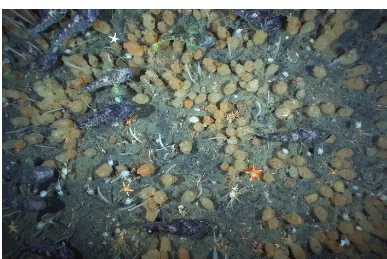
Figure 3.Example of a seabed photo taken duringPolarsterncruise ANT-XXIX/3 (PS81) from January to March 2013, showing abundant
466 D. Piepenburg et al.: Seabed images from Southern Ocean shelf regions
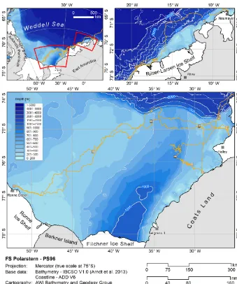
Figure 4.Maps showing the geographic positions of OFOS stations in the Weddell Sea duringPolarsterncruise ANT-XXXI/2 (PS96) from
December 2015 to February 2016 (after Schröder, 2016). Bathymetric data from IBCSO (Arndt et al., 2013).
(PS81) cruise to the Antarctic Peninsula from January to March 2013 (for cruise report, see Gutt, 2013) and the ANT-XXXI/2 (PS96) cruise to the Weddell Sea from Decem-ber 2015 to February 2016 (for cruise report, see Schröder, 2016).
2.2.1 Polarsterncruise ANT-XXIX/3 (PS81)
During cruise PS81, OFOS was successfully deployed at a total of 31 stations at water depths between 29 and 784 m (Ta-ble 1), delivering a total of more than 15 000 seabed photos (Gutt, 2013). At most stations, series of 500 to 530 pictures were taken along transects approximately 3700 m (2 nautical miles) in length during net wire times (with OFOS at the bot-tom) of 4 h per transect. At some stations, OFOS had to be deployed for shorter periods of time due to high wave heights and strong winds.
The stations were placed in three regions off the Antarctic
Peninsula between 61 and 64◦S: the northwestern Weddell
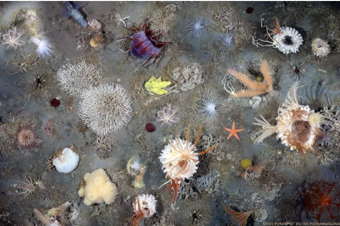
Figure 5.Example of photographic material gathered duringPolarsterncruise ANT-XXXI/2 (PS96) to the Weddell Sea from December 2015 to February 2016, showing a compilation of epibenthic megafauna recorded at station PS96/090 on the shelf off the Riiser-Larsen Ice Shelf (Rampen) at water depths from 265 to 310 m on 29 January 2016 (collage created from 25 clips of seabed images using Adobe Photoshop).
deep or canyon. In the Drake Passage, where the bottom topography was similar albeit less pronounced than in the Bransfield Strait, three habitat blocks were also sampled. In the northern Weddell Sea, stations were selected to cover a range of habitats that are as comparable as possible to those sampled in the Bransfield Strait. Four stations were situated at the northeastern side of the Nachtigaller Shoal on the west-ern Weddell Sea shelf (Dorschel et al., 2014).
Figure 3 is an example of a seabed photo taken at station PS81/110, showing rich megabenthic epifauna (e.g., abun-dant ascidians and a swarm of demersal nototheniid fish) on the shelf off Joinville Island in the eastern Bransfield Strait at 212 m of water depth on 26 January 2013.
2.2.2 Polarsterncruise ANT-XXXI/2 (PS96)
During cruise PS96, OFOS was deployed at a total of 13 sta-tions at water depths between 200 and 750 m (Table 2). Dur-ing the casts with 54 min to 2 h 14 min of on-ground duration, series of 110 to 293 photos (2670 in total) were obtained along OFOS transects 0.9 to 2.6 km in length. In addition, a total of more than 14 h 50 min of video footage (available from the first author on request) was recorded.
OFOS stations were distributed over several regions in the southeastern and southern Weddell Sea (Fig. 4). (1) Off Austasen, one transect (PS96/001) was positioned in close vicinity to the BENDEX sites investigated in 2003, 2011, and 2014 (Biebow et al., 2014). Unfortunately, the actual main BENDEX location, artificially disturbed in 2003, could not be revisited, since it was located under fast ice and
hence not accessible in December 2015. (2) Four stations (PS96/026, 027, 037, and 048) were located in the main study area of the PS96 cruise, which is the broad shelf of the southern Weddell Sea west of Filchner Trough. (3) Five stations (PS96/007, 008, 010, 057, and 061) were situated on the shelf east of Filchner Trough. Some of these sta-tions were revisits of sites that had been investigated dur-ing Polarstern cruise PS82 in 2014 (Knust and Schröder, 2014) using seabed imaging gear other than OFOS: (a) sta-tion PS96/008 was close to the posista-tion of stasta-tion PS82/277
(74◦54.30S, 29◦40.10W), where in 2014 evidence of
dem-ersal eggs and nesting and parental care behavior (guarded fish nests) had been recorded; (b) and station PS96/057 was
a revisit of an ROV track made in 2014 (from 79◦19.10S,
29◦02.00W to 79◦19.30S, 29◦00.90W; available on request
from Claudio Richter at AWI) close to the coast of Coats Land at water depths of about 240 m, where a rich sponge-dominated seabed fauna had been recorded. (4) One station (PS96/072) was located in Filchner Trough itself at about 750 m of depth. (5) Two additional stations (PS96/090 and 106) were situated on the southeastern Weddell Sea shelf close to the mouths of inlets on the edge of the Riiser-Larsen Ice Shelf.
468 D. Piepenburg et al.: Seabed images from Southern Ocean shelf regions T ab le 2. List of stations at which the A WI Ocean Floor Observ ation System (OFOS) w as deplo yed during P olar stern cruise ANT -XXXI/2 (PS96) in the W eddell Sea from Decem-ber 2015 to February 2016. Latitude (◦ S); longitude (◦ W). Start transect End transect T ransect data PS96/# Area Date /time Latitude Longitude Depth (m) Date/time Latitude Longitude Depth (m) Duration (h) Length (km) No. of photos 001-4 Austasen 2015-12-23 20:44 − 70.88656 − 11.10862 315 2015-12-23 22:20 − 70.89597 − 11.14651 293 01:36 1.74 204 007-1 Filchner east 2015-12-25 16:08 − 74.65717 − 26.94170 412 2015-12-25 17:55 − 74.66767 − 26.99817 414 01:47 2.58 239 008-2 Filchner east 2015-12-30 18:29 − 74.91990 − 29.42032 398 2015-12-30 20:25 − 74.90734 − 29.40633 402 01:56 1.49 258 010-3 Filchner east 2016-01-01 11:49 − 74.94354 − 26.03907 291 2016-01-01 13:52 − 74.95666 − 26.08317 290 02:03 1.94 266 026-3 Filchner west 2016-01-08 01:55 − 75.28338 − 37.91191 414 2016-01-08 03:58 − 75.26742 − 37.91914 412 02:03 1.87 281 027-2 Ronne Depot 2016-01-14 14:10 − 76.71955 − 52.19319 292 2016-01-14 14:09 − 76.71915 − 52.15999 293 00:59 0.85 110 037-3 Filchner west 2016-01-16 13:53 − 75.72218 − 42.46356 386 2016-01-16 15:05 − 75.71473 − 42.44772 386 01:12 0.93 137 048-2 Filchner west 2016-01-18 20:23 − 74.77064 − 35.30750 490 2016-01-18 22:25 − 74.75814 − 35.34624 479 02:02 1.81 271 057-3 Filchner east 2016-01-21 01:29 − 76.31746 − 29.03351 238 2016-01-21 02:35 − 76.32195 − 29.00603 243 01:06 0.90 131 061-1 Filchner east 2016-01-21 18:12 − 76.09967 − 30.30060 469 2016-01-21 19:42 − 76.09070 − 30.33800 480 01:30 1.41 219 072-4 Filchner T rough 2016-01-23 17:06 − 75.86119 − 32.38293 751 2016-01-23 18:30 − 75.85799 − 32.33833 747 01:24 1.24 194 090-4 Rampen 2016-01-29 01:29 − 72.43428 − 17.03233 281 2016-01-29 03:43 − 72.44379 − 17.08049 302 02:14 1.95 292 106-2 Christmas T ree Inlet 2016-01-31 08:27 − 72.60807 − 17.87568 194 2016-01-31 09:29 − 72.60767 − 17.90184 211 01:02 0.90 134
3 Data availability
All images taken during the two cruises, including meta-data, are available from the data publisher PANGAEA (Piepenburg et al., 2013, for PS81; Piepenburg, 2016, for PS96). Images are listed with a georeference and time for each transect in single-child datasets. All tran-sects for each cruise are grouped in a parent dataset (PS81: https://doi.org/10.1594/PANGAEA.872719; PS96: https://doi.org/10.1594/PANGAEA.862097). This granular-ity ensures detailed metadata information for each image and each transect. A station map in Google Earth format (kmz) is provided with hot links to the images; see the “Further details” section in the dataset description from PANGAEA. For convenient download of one or multiple image datasets from PANGAEA, special software tools (including instruc-tions on how to install and use them) are available (Sieger, 2012; Buschmann, 2016). Ancillary environmental data for PS81 can be found in Dorschel et al. (2016).
An example for a scientific study based on the analyses of the seabed images, the collection of which are reported here, is an investigation of the composition and distribution patterns of the epibenthic ascidian fauna on the shelves off the Antarctic Peninsula (Segelken-Voigt et al., 2016b). The supplementary information used in this study, including envi-ronmental data, is also available from PANGAEA (Segelken-Voigt et al., 2016a). A second example is the investigation of the influence of geomorphological and sedimentological set-tings on the distribution of epibenthic assemblages on
the Nachtigaller Shoal, a flat-topped submarine hill at the over-deepened shelf of the western Weddell Sea discovered during the PS81 cruise in 2013 (Dorschel et al., 2014).
Competing interests. The authors declare that they have no
con-flict of interest.
Acknowledgements. We would like to thank the HGF-MPG
Joint Research Group for Deep-Sea Ecology and Technology at the Alfred Wegener Institute, Helmholtz Centre for Polar and Marine Research Bremerhaven, for providing access to OFOS during
Polarsterncruises PS81 and PS96. The sampling of seabed images during the two cruises was supported by grants AWI_PS81_03 and AWI_PS96_02.
Edited by: Falk Huettmann
References
Arndt, J.-E., Schenke, H.W., Jakobsson, M.N., Nitsche, F.-O., Buys, G., Goleby, B., Rebesco, M., Bohoyo, F., Hong, J.K., Black, J, Greku, R., Udintsev, G., Barrios, F., Reynoso-Peralta, W., Taisei, M., and Wigley, R.: The International Bathymetric Chart of the Southern Ocean Version 1.0 – A new bathymetric compilation covering circum-Antarctic waters, Geophys. Res. Lett., 40, 1–7, https://doi.org/10.1002/grl.50413, 2013.
Barnes, D., Griffiths, H., and Kaiser, S.: Geographic range shift responses to climate change by Antarctic benthos: where we should look, Mar. Ecol.-Prog. Ser., 393, 13–26, https://doi.org/10.3354/meps08246, 2009.
Bergmann, M. and Klages, M.: Increase of litter at the Arctic deep-sea observatory HAUSGARTEN, Mar. Pollut. Bull., 64, 2734– 2741, https://doi.org/10.1016/j.marpolbul.2012.09.018, 2012. Biebow, H., Gerdes, D., Isla, E., Knust, R., Pineda, S., and
Sands, C.: The BENDEX experiment: follow-up 2. in: The expedition PS82 of the research vessel “Polarstern” to the southern Weddell Sea in 2013/14, edited by: Knust, R. and Schröder, M., Ber. Polarforsch, Meeresforsch., 680, 94–98, https://doi.org/10.2312/BzPM_0680_2014, 2014.
Buschmann, A.: PANGAEA UW-photo download helper
for macOS. Alfred Wegener Institute, Helmholtz
Cen-tre for Polar and Marine Research, Bremerhaven,
https://doi.org/10.1594/PANGAEA.869477, 2016.
Dorschel, B., Gutt, J., Piepenburg, D., Schröder, M., and Arndt, J. E.: The influence of the geomorphological and sedimento-logical settings on the distribution of epibenthic assemblages on a flat topped hill on the over-deepened shelf of the western Weddell Sea (Southern Ocean), Biogeosciences, 11, 3797–3817, https://doi.org/10.5194/bg-11-3797-2014, 2014.
Dorschel, B., Gut,t J., Huhn, O., Bracher, A., Huntemann, M., Gebhardt, C., Huneke, W., and Schröder, M.: Envi-ronmental information for a marine ecosystem research ap-proach for the northern Antarctic Peninsula (RV Polarstern expedition PS81, ANT-XXIX/3), Polar Biol., 39, 765–787, https://doi.org/10.1007/s00300-015-1861-2, 2016.
Gage, J. D. and Tyler, P. A.: Deep-sea biology: a natural history of organisms at the deep-sea floor, Cambridge University Press, Cambridge, 1991.
Gili, J., Arntz, W., Palanques, A., Orejas, C., Clarke, A., Dayton, P., Isla, E., Teixidó, N., Rossi, S., and López-González, P.: A unique assemblage of epibenthic sessile suspension feeders with archaic features in the high-Antarctic, Deep-Sea Res. Pt. II, 53, 1029– 105, https://doi.org/10.1016/j.dsr2.2005.10.021, 2006.
Gutt, J.: Coexistence of macro-zoobenthic species on the
Antarctic shelf: An attempt to link ecological
the-ory and results, Deep-Sea Res. Pt. II, 53, 1009–1028, https://doi.org/10.1016/j.dsr2.2006.02.012, 2006.
Gutt, J.: Antarctic macro-zoobenthic communities: a review and an ecological classification, Antarct. Sci., 19, 165–182, https://doi.org/10.1017/S0954102007000247, 2007.
Gutt, J. (Ed): The expedition of the research vessel “Polarstern” to the Antarctic in 2013 (ANT-XXIX/3), Ber. Polarforsch. Meeres-forsch., 665, 1–150, https://doi.org/10.2312/BzPM_0665_2013, 2013.
Gutt, J., David, B., Isla, E., and Piepenburg D.: High envi-ronmental variability and steep biological gradients in the waters off the northern Antarctic Peninsula: Polarstern ex-pedition PS81 (ANT-XXIX/3), Polar Biol., 39, 761–959, https://doi.org/10.1007/s00300-016-1937-7, 2016.
Knust, R. and Schröder, M. (Eds): The expedition PS82 of the research vessel POLARSTERN to the southern Weddell Sea in 2013/2014, Ber. Polarforsch. Meeresforsch., 680, 1–155, https://doi.org/10.2312/BzPM_0680_2014, 2014.
Piepenburg, D.: Seabed photographs taken along OFOS
profiles during POLARSTERN cruise PS96
(ANT-XXXI/2 FROSN), Alfred Wegener Institute, Helmholtz
Center for Polar and Marine Research, Bremerhaven,
https://doi.org/10.1594/PANGAEA.862097, 2016.
Piepenburg, D., Segelken-Voigt, A., and Gutt, J.: Seabed pho-tographs taken along OFOS profiles during POLARSTERN
cruise PS81 (ANT-XXIX/3), Alfred Wegener Institute,
Helmholtz Center for Polar and Marine Research, Bremer-haven, https://doi.org/10.1594/PANGAEA.862719, 2013. Schröder, M. (Ed): The expedition PS96 of the research
vessel “Polarstern” to the southern Weddell Sea in
2015/16, Ber. Polarforsch. Meeresforsch., 700, 1–142,
https://doi.org/10.2312/BzPM_0700_2016, 2016.
Segelken-Voigt, A., Bracher, A., Dorschel, B., Gutt, J., Huneke, W., Link, H., and Piepenburg, D.: Spatial distribution pat-terns of ascidians (Ascidiacea: Tunicata) in combination with information on bathymetry, oceanography, chlorophyll-a, and sea-ice on the continental shelves off the northern Antarc-tic Peninsula during POLARSTERN cruise ANT-XXIX/3, https://doi.org/10.1594/PANGAEA.849291, 2016a.
Segelken-Voigt, A., Bracher, A., Dorschel, B., Gutt, J., Huneke, W., Link, H., and Piepenburg, D.: Spatial distribution patterns of ascidians (Ascidiacea: Tunicata) on the continental shelves off the northern Antarctic Peninsula, Polar Biol., 39, 863–879, https://doi.org/10.1007/s00300-016-1909-y, 2016b.
Sieger, R.: PanGet – downloads multiple data sets from
PANGAEA. Alfred Wegener Institute, Helmholtz
Cen-tre for Polar and Marine Research, Bremerhaven,