HYBRID OPTIMIZATION ALGORITHM FOR GEOGRAPHIC
ROUTING IN VANET
1A. TAMIZHSELVI, 2 R. S. D. WAHIDA BANU
1
Department of Information and Technology, St. Joseph’s College of Engineering, Chennai, India
2Department of Electronics and Communication Engineering, Government College of Engineering,
Chennai, India
E-mail: [email protected]
ABSTRACT
Vehicular Ad-hoc Networks (VANETs) developed rapidly in the last decade which is widely used to improve safety and traffic efficiency. VANET is an active research, standardization and development area due to its potential to improve vehicle and road safety, traffic efficiency, and convenience keeping in mind drivers and passengers comfort. Though VANETs geographic routing was recently emphasized, developing such networks multi-hop communication is challenging because of changing topology and network disconnections leading to Mobile Ad-hoc NETwork (MANET) routing protocols failures and inefficiency. This study proposes hybrid Particle swarm Optimization (PSO) with Broyden-Fletcher-Goldfarb-Shanno to improve the efficiency of Geographical Routing Protocol (GRP). Simulation results demonstrate that the proposed modified GRP using Hybrid PSO with BFGS, effectively improves the packet delivery ratio, and reduces the end to end delay.
Keywords: Particle Swarm Optimization (PSO); Broyden-Fletcher-Goldfarb-Shanno (BFGS); Geographical Routing Protocol (GRP); Vehicular Ad-hoc NETworks (VANETs)
1. INTRODUCTION
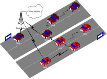
Vehicular Ad-hoc Networks (VANETs) are a special case Mobile Ad-hoc NETwork (MANET) [1] whose main feature is high node mobility. Immediate consequences include topology changes and link disconnection. VANET topology changes due to high speed vehicle movement. It is an
autonomous, self-organizing wireless
communication network, where VANET nodes become servers and/or clients to exchange, share information. VANET network architecture is divided into three categories; pure cellular/WLAN, pure ad hoc, and hybrid [2]. VANET vision includes frequent data exchange by vehicles (or nodes) to ensure route planning, road safety and e-commerce uses. Network security is important for every application [3]. Traditional network security approach involves a management solution allowing
data integrity and network “insiders”
[image:1.595.318.530.467.624.2]authentication.
Figure 1: Vehicle Ad Hoc Network Architecture
vehicular safety, reducing traffic congestion while
offering access to Location Based Service (LBS) applications.
VANETs anticipate supporting mobile
distributed applications ranging from dynamic route planning to traffic alert dissemination, to file
sharing and context-aware advertisement.
Considering the many nodes in these networks and their mobility, debates exist about applications
feasibility of using end-to-end multi-hop
communication [5]. The concern is whether VANET routing protocols can satisfy applications’ throughput and delay requirements. VANET’s goal is ensuring passengers safety and comfort. Each VANET equipped vehicle is an Ad-hoc network node receiving and relaying other messages through wireless networks.
VANET routing protocols are split into five categories: Position based routing protocol, Topology based routing protocol, Geo cast routing protocol, Cluster based routing protocol and Broadcast routing protocol all of which are characterized based on area/application which suits them [6].
Topology based routing protocols use network link information to forward packets. They are also divided into Proactive and Reactive protocols. Position based routing is a routing algorithm class. Vehicles near each other form a cluster in Cluster-based routing protocols. Each cluster has a cluster-head responsible for intra/inter-cluster management functions. Intra-cluster nodes communicate using direct links while inter-cluster communication is via cluster headers [6] [7]. Cluster formation and selection of cluster-head is a major issue in cluster based routing protocols. High mobility and dynamic cluster formation are a towering process in VANETs. They share the characteristic of using geographic positioning information to select next forwarding hops. VANETs use broadcast routing to share traffic, weather and emergency road conditions among vehicles and also to deliver advertisements and announcements. Geo cast routing is a location based multicast routing with the aim of delivering a packet from source to all nodes in a specific geographical region (Zone of Relevance ZOR).
In geographic routing, a node’s forwarding decision is based on the packet’s destination position, and the node’s one-hop neighbors position [8]. The destination position is stored in the packet header by source. The node’s one-hop neighbor’s position is got through beacons sent periodically
with random jitter (to prevent collision). Nodes within another’s radio range become neighbors. Geographic routing requires lower node memory
through locally maintained information.
Geographic routing includes location service and geographic forwarding processes [9].
Routing protocol algorithms choose criteria for routing decisions; hops number, transmission power, latency and bandwidth [1]. Topology-based routing protocols suffer from discovery and maintenance phases, lack of scalability and mobility effects (short links). But, geographic routing suits large scale dynamic networks. Location-Aided Routing is the first routing protocol to use geographic information.
Optimization block is through a meta-heuristic method, here, one of the followings is used: Particle Swarm Optimization (PSO), Differential Evolution (DE), Genetic Algorithm (GA), and Simulated Annealing (SA). These were conceived to find optimal (or quasi-optimal) solutions in continuous search spaces, which is the case here. This procedure is undertaken through a ns-2 [10] network simulator, to simulate VANETs. For this investigation, ns-2 was modified to interact automatically with optimization procedure aimed at accepting new routing parameters and opening ways for future research. Hybrid algorithms help overcome the shortcomings of the individual optimization method.
The need for this study is linked vehicle’s data exchange expansion aiming to provide dedicated applications for Intelligent Transportation Systems (ITS). This study suggests a hybrid PSO with
Broyden-Fletcher-Goldfarb-Shanno (BFGS)
algorithm for VANETs to improve routing using geographic routing protocol. The reminder of this research is organized as follows. Related work of routing in VANETs is discussed in section 2. PSO and BFGS are described in section 3 with section 4 presenting experimental results. Conclusions are finally made in section 5.
2. LITERATURE REVIEW
OLSR. In experiments, the suggested OLSR
configurations led to better quality of service (QoS) than standard request for comments (RFC 3626), as also several human experts, making it amenable to utilize in VANET configurations.
An improved Greedy Traffic-Aware Routing protocol (GyTAR) was introduced by Jerbi, et al. [11] which was an intersection-based geographical routing protocol capable of locating robust and optimal routes in urban environments. GyTAR principle was dynamic and in-sequence selection of intersections through which data packets are forwarded to destinations. Intersections considered parameters like remaining distance to destination and vehicular traffic variations. Data forwarding among intersections in GyTAR uses an improved
greedy carry-and-forward mechanism. When
evaluated, the proposed routing protocol revealed performance improvement when compared to other routing approaches. Through simulations, GyTAR
parameters optimality and sensitivity were
validated.
A vehicular mobility model reflecting real-world vehicle movement was proposed by Wang et al.
[12] who studied packet-routing protocols
performance. First, it studied routing in small-scale VANETs proposing two routing schemes: (1) Connection-Based Restricted Forwarding (CBRF) and (2) Connection-Less Geographic Forwarding (CLGF). Different areas in Orlando city, Florida validated the design philosophy and routing protocol and generated vehicular mobility traces, following the suggested mobility models. The authors fed traces to network simulators, studying routing behavior. Simulation proved the proposed routing protocol’s performance and effectiveness for large-scale VANET scenarios.
Balancing network traffic load when data generated in a wireless sensor network is stored on sensor nodes was addressed by Renda et al. [13]. They accessed a geographic hash table through querying and suggested “reverse engineering” hash function to store data in network, implement a sort of “load-aware” assignment of key ranges to wireless sensor nodes. Simulation showed the effectiveness of both the proposed approaches in improving load balancing and extending network life greatly. Simulation results also revealed that the suggested technique achieved better load balancing than current modifying geo routing based approach.
Geographic routing protocol variants that needed no beacons to avoid problems were proposed by Sanchez et al. [14]. Geographic routing is today an
efficient and scalable routing solution for Wireless Sensor Networks (WSN). Each node exchanges periodic one-hop beacons to determine neighbor’s position in conventional geographic routing protocols. Studies proved these beacons created problems in real deployments due to wireless links highly dynamic and error-prone nature. Latest proposals in beacon-less geographic routing were reviewed introducing design challenges and alternatives. An empirical study to assess performance of beacon-based and beacon-less routing protocols using a real WSN was performed
A geographical routing algorithm called
Location-Aware Routing for Delay-tolerant
networks (LAROD) was proposed by Kuiper and Nadjm-Tehrani [15] which enhanced with a location service, Location Dissemination Service (LoDiS) that together suit Intermittently Connected MANET (IC-MANET). As location dissemination in IC-MANETs takes time, LAROD with partial knowledge of geographic position was designed to route packets. LAROD used a beaconless strategy with a position-based bids resolution when forwarding packets to achieve low overhead. LAROD-LoDiS was compared to a leading delay-tolerant routing algorithm (spray and wait) and revealed that it had a competitive edge, regarding delivery ratio and overhead. This case involved a new packet-level implementation in ns-2 as opposed to original connection-level custom simulator for spray and wait.
A novel geographic routing for mobile sinks was proposed by Yu et al. [16]. Frequent mobile sinks location updates leads to rapid sensor nodes energy consumption and increased wireless transmissions collisions. The proposed scheme uses the wireless broadcast transmission nature of WSNs. When a sink moves, new location information is propagated by reverse geographic routing path to source during data delivery. Analysis and simulation results reveal that elastic routing was better than other protocols as regards data delivery delay, control overhead and energy consumption.
A distributed Dead-end Free Topology
Maintenance protocol, designated DFTM, for construction of dead-end free networks using minimum active nodes was presented by Chou et al. [17]. DFTM performance was compared to conventional topology maintenance schemes GAF and Span, in numerical simulations using ns2 simulator. Evaluation results showed that DFTM reduced number of active nodes needed in network,
successfully constructed a dead-end free topology
in most simulations.
A concept of flow network PNP0 to convert it into particular minimum cost flow problem and overcome minimum cost flow problem based on network probability flow was presented by Huang et al. [18]. Incremental maintenance algorithms to adapt to VANET's real-time property were proposed. Simulation proved that the suggested method worked achieving targets with low network
congestion. Due to selfish nodes, nodes
transmission reliability is uncertain due to which routes reliability is considered. The optimization problem is suggested to maximize profit on the ground that it maximizes network's load above certain reliability. To offset this, a reliability concept was introduced into network flow theory, and the idea of a flow network probability was proposed.
A simple, yet novel, event-driven geographic routing protocol GeoCross that removed cross-links to prevent routing loops in urban VANETs was proposed by Lee et al. [19]. GeoCross used urban maps natural planar feature without recourse to cumbersome planarization. Its dynamic loop detection feature makes GeoCross suit mobile VANETs. In pathologic cases, the results reveal that GeoCross’s packet delivery ratio (PDR) was higher than Greedy Perimeter Stateless Routing’s (GPSR’s) and Greedy Perimeter Coordinator Routing’s (GPCR’s) while caching (GeoCross + Cache) provided similar PDR with lesser hops.
Traffic control scenarios and potential benefits were analyzed and presented for economic loss avoidance by Benyahia et al. [20]. A traffic control is needed for congestion minimisation to deal with costs. Connected vehicles based on inter-vehicle communications represent a solution as they share information on traffic and on a new vehicle routing’s processed information. Dynamic routing of connected vehicles communications innovations will avoid or minimize traffic congestions using real-time diversions.
The design of a Geocast security solution based on cryptographic protection, plausibility checks using secure neighbor discovery and mobility-related checks, trusted neighborhood assessment and rate limitation was presented by Festag, et al. [21]. The proposed scheme’s achieved security level was analyzed, and its overhead and performance assessed. Also, a software-based prototype implementation for a secure vehicular communication system was developed. The
proposed security measures resulted in a network performance bottleneck in real vehicular scenarios. Finally, analysis of tradeoff between security overhead and protocol performance determined
minimal processing overhead, required for
acceptable performance.
3. METHODOLOGY
Hybrid Particle Swarm Optimization (PSO) with Broyden-Fletcher-Goldfarb-Shanno for improved Geographical Routing Protocol (GRP) efficiency is proposed. Optimization solves VANET routing issues. The methods involved are as follows:
3.1 Particle Swarm Optimization (PSO)
PSO is a technique to explore a given problem’s search space to locate settings or parameters to maximize a specific objective [22]. Optimization allows one to find a function or process’s maximum/minimum value. In optimization tasks, called constrained optimization tasks, candidate solution elements are subject to some constraints (like being greater or lesser than zero).
PSO is a computational intelligence-based technique mostly unaffected by a problem’s size and nonlinearity and converges to an optimal solution in problems where analytical methods do not converge. It can be applied to various optimization problems in power systems. Evolution of PSO is possible by incorporating methods already tested in other evolutionary computation techniques.
3.2 Advantages Of PSO Over Other Optimization Techniques:
1) PSO is easier to implement as it has fewer parameters to adjust.
2) In PSO, all particles remember their previous best value and also the neighborhood best; hence, it has better memory capability than GA.
3) PSO is more efficient in maintaining swarm diversity [23] (similar to ideal social interaction in a community) as all particles use information related to the most successful particle to improve themselves, while in GA, worst solutions are discarded and only good ones saved; so, population evolves around a subset of best individuals in GA.
competition. A single particle’s evolution
mechanism in canonical PSO is described as follows [24]:
[image:5.595.99.503.321.727.2]where Vid and Xid represent particle velocity and position i in the dth dimension, respectively, w is inertial weight that allows a tradeoff between global and local search abilities, c1 and c2 are acceleration constants, r1 and r2 are random numbers in the range [0, 1], pbestid is the best position found till then regarding particle i in dth dimension, and gbestd is globally best position visited by all particles.
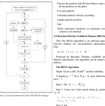
Figure 2: General framework of the PSO-BFGS strategy
3.3 The Pseudo Code For The PSO Algorithm [25]
For each particle
Initialize particle
End
Do
For each particle
Calculate fitness value
If the fitness value is better than the best
fitness value (pbest) in history set current
value as the new pbest
End
Choose the particle with the best fitness value of all the particles as the gbest
For each particle
Calculate particle velocity according
Update particle position
End
While maximum iterations or minimum error criteria is not attained.
3.4 Broyden-Fletcher-Goldfarb-Shanno (BFGS)
This The BFGS algorithm is an efficient quasi-Newton method for unconstrained optimization [26]:
m i n f ( x ) , x R n ∈
Proposed by Broyden, Fletcher, Goldfarb, and Shanno individually, the algorithm can be stated as follows.
The BFGS algorithm
Step0. Given x1∈Rn; B1∈Rn×n positive definite;
Compute g1 = ∇ f(x1). If g1 = 0; stop; otherwise,
set k = 1.
Step 1: Set
d
kB g
k−1 k=
−
Step 2: Carry out a line search along dk, getting
∝k> 0,
where
(1.3) sk = ∝kdk;
(1.4)
y
k= g
k+1-g
k:
Step 4: k = k + 1; go to Step 1:
4. RESULTS AND DISCUSSION
[image:6.595.313.511.191.329.2]A simulation testbed of 20 nodes is considered to evaluate the proposed method. The nodes have random trajectory and are spread in a 2000 m by 2000 m area. The data rate of each node is 11 Mbps with a transmit power of 0.005 watts. Simulations are run for 400 sec. Figure 3 show end to end delay simulation results.
Figure 3: End to End delay
It is seen from Figure 3 that the performance of proposed method in terms of end to end delay decreases significantly by 23.52% with GRP in 10 kmph and by 5.79 % with PSO-GRP in 50 kmph.
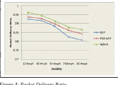
Figure 4: Packet Delivery Ratio
It is seen from the Figure 4 that the performance of proposed method in terms of Packet delivery
[image:6.595.99.292.337.460.2]ratio improved by 6.95% with GRP in 90 kmph and by 2.91% with PSO-GRP in 90 kmph.
Figure 5: Jitter
It is seen from the Figure 5 that the performance of proposed method in terms of jitter decreases by 27.07% with GRP in 10 kmph and by 21.86% with PSO-GRP in 10 kmph. It can be seen that the proposed modified protocol reduces the jitter when compared to the existing GRP.
5. CONCLUSION
VANET development is a welcome advancement in information technology growth, and a continuing broadening of present wireless network capabilities. But, despite benefits, information security threats and privacy issues are challenges to VANET expansion and usage. An interesting part of the network is its ability to self-organize in highly mobile network environment. Routing is important for vehicle-to-vehicle (V2V) and infrastructure-to-vehicle (I2V) communication. Designing efficient routing protocols for VANET applications is hard. This study proposes a hybrid of Particle Swarm Optimization (PSO) and BFGS to improve efficiency of Geographical Routing Protocol (GRP) the optimization of which reduces end to end delay and improves network packet delivery ratio. Simulation showcases that modified GRP using hybrid PSO, improved packet delivery ratio and reduced jitter and end to end delay effectively.
REFRENCES
[1]. Ayaida, M., Barhoumi, M., Fouchal, H., Ghamri-Doudane, Y., & Afilal, L. (2012, December). HHLS: A hybrid routing technique for VANETs. In
Global Communications Conference
[image:6.595.98.295.571.712.2][2]. Paul, B., Ibrahim, M., Bikas, M., & Naser, A.
(2012). VANET Routing Protocols: Pros and Cons. arXiv preprint arXiv:1204.1201.
[3]. Golle, P., Greene, D., & Staddon, J. (2004, October). Detecting and correcting malicious data in VANETs. In Proceedings of the 1st ACM international workshop on Vehicular ad hoc networks (pp. 29-37). ACM.
[4]. Sampigethaya, K., Li, M., Huang, L., & Poovendran, R. (2007). Amoeba: Robust location privacy scheme for vanet. Selected Areas in Communications, IEEE Journal on, 25(8), 1569-1589.
[5]. Nzouonta, J., Rajgure, N., Wang, G., & Borcea, C. (2009). VANET routing on city roads using real-time vehicular traffic information. Vehicular Technology, IEEE Transactions on, 58(7), 3609-3626.
[6]. Nagaraj, U., & Dhamal, P. (2012). Broadcasting Routing Protocols in VANET. Network and Complex Systems, 1(2), 13-19.
[7]. Kohli, S., Kaur, B., & Bindra, S. (2010). A comparative study of Routing Protocols in VANET. Proceedings of ISCET.
[8]. Kohli, S., Kaur, B., & Bindra, S. (2010). A comparative study of Routing Protocols in VANET. Proceedings of ISCET.
[9]. Tamizhselvi, A., & Banu, R. W. (2013). Enhancing Geographical Routing Protocol Using Swarm Intelligence. Life Science Journal, 10(7s).
[10]. Toutouh, J., García-Nieto, J., & Alba, E. (2012). Intelligent OLSR routing protocol optimization for
VANETs. Vehicular Technology, IEEE
Transactions on, 61(4), 1884-1894.
[11]. Toutouh, J., García-Nieto, J., & Alba, E. (2012). Intelligent OLSR routing protocol optimization for
VANETs. Vehicular Technology, IEEE
Transactions on, 61(4), 1884-1894.
[12]. Wang, W., Xie, F., & Chatterjee, M. (2009). Small-scale and large-scale routing in vehicular ad hoc networks. Vehicular Technology, IEEE Transactions on, 58(9), 5200-5213.
[13]. Wang, W., Xie, F., & Chatterjee, M. (2009). Small-scale and large-scale routing in vehicular ad hoc networks. Vehicular Technology, IEEE Transactions on, 58(9), 5200-5213.
[14]. Sanchez, J., Ruiz, P., & Marin-Perez, R. (2009). Beacon-less geographic routing made practical: challenges, design guidelines, and protocols. Communications Magazine, IEEE, 47(8), 85-91. [15]. Kuiper, E., & Nadjm-Tehrani, S. (2011).
Geographical routing with location service in
intermittently connected MANETs. Vehicular Technology, IEEE Transactions on, 60(2), 592-604. [16]. Yu, F., Park, S., Lee, E., & Kim, S. H. (2010). Elastic routing: a novel geographic routing for mobile sinks in wireless sensor networks. IET communications, 4(6), 716-727.
[17]. Chou, C. H., Ssu, K. F., Jiau, H. C., Wang, W. T., & Wang, C. (2011). A dead-end free topology maintenance protocol for geographic forwarding in wireless sensor networks. Computers, IEEE Transactions on, 60(11), 1610-1621.
[18]. Huang, W., Yang, H., & Wang, L. (2012, November). Probablity Flow Model Based Route Optimization Method for VANET. In Green Computing and Communications (GreenCom), 2012 IEEE International Conference on (pp. 116-123). IEEE.
[19]. Lee, K. C., Cheng, P. C., & Gerla, M. (2010). GeoCross: A geographic routing protocol in the presence of loops in urban scenarios. Ad Hoc Networks, 8(5), 474-488.
[20]. Benyahia, I., Ahadjitse, Y., & Shawky, M. Dynamic Optimisation of VANET Routing for Trip
Delays Minimisation. http://www.
itscanada.ca/files/Reports/Ilham%20Paper%20IB-ACGM-2012.pdf
[21]. Festag, A., Papadimitratos, P., & Tielert, T. (2010). Design and performance of secure geocast
for vehicular communication. Vehicular
Technology, IEEE Transactions on, 59(5), 2456-2471
[22]. Blondin, J. (2009). Particle swarm optimization: A tutorial. from site: http://cs. armstrong. edu/saad/csci8100/pso tutorial. pdf.
[23]. del Valle, Y., Venayagamoorthy, G. K., Mohagheghi, S., Hernandez, J. C., & Harley, R. G.
(2008). Particle swarm optimization: basic
concepts, variants and applications in power
systems. Evolutionary Computation, IEEE
Transactions on, 12(2), 171-195.
[24]. Li, S., Tan, M., Tsang, I. W., & Kwok, J. Y. (2011). A hybrid PSO-BFGS strategy for global optimization of multimodal functions. Systems, Man, and Cybernetics, Part B: Cybernetics, IEEE Transactions on, 41(4), 1003-1014.
[25]. Sambrani, P. C., & Biradar, D. A. Efficient Routing In Wireless Ad Hoc Networks Using Bio Inspired Algorithms. International Conference on Computer Science and Engineering (CSE) 7thApril 2013, Bangalore, PP: 8-11.