International Journal of Emerging Technology and Advanced Engineering
Website: www.ijetae.com (ISSN 2250-2459, ISO 9001:2008 Certified Journal, Volume 6, Issue 6, June 2016)48
Gradual Trends of Groundwater Table Depletion with
Relevant
Consequences on Water Quality in Dhaka City,
Bangladesh
Md. Mahfujur Rahman
1, Nazia Nawrin
2, Mst. Maksuda Akter
3, Farha Khan
4, Shamina Nahar
5,
Md. Tariqul Islam
61,2,4,5,6 Department of Geology, University of Dhaka, Dhaka-1000, Bangladesh 3 Department of Chemistry, University of Rajshahi, Rajshahi-6205, Bangladesh
Abstract— Dhaka, the capital of Bangladesh is one of the largest megacities in the world in terms of its increasing population and there, demand of safe water is rising inevitably day by day. Currently maximum portion (85-90%) of its water supply comes from groundwater. Excess exploitation of groundwater than safe yield resulting rapid groundwater level declination. Upper Dupi Tila Aquifer is almost dried up and the confined aquifer has become unconfined in nature under large parts of the city. An extensive cone of depression has been developed outwards to the rivers which are bounding the Dhaka city. As a result productivity of wells has also been decreasing significantly. Now sustainability of the aquifer and vulnerability to contamination are the issues of great importance. Natural recharge to the groundwater aquifer is insufficient to balance the abstraction rate. Moreover water quality is being deteriorated by seepages from areas of urban and industrial contamination and leakages from polluted rivers. This research focuses on the groundwater table depletion in response to over abstraction of groundwater and in consequences of water quality deterioration.
Keywords— Dhaka city, Groundwater level, Over abstraction, Contamination, Water quality
I. INTRODUCTION
Dhaka is located in the central part of Bangladesh and situated on the northern bank of the Buriganga River (Figure 1). Dhaka district covers an area of 1528 sq. km (RAJUK 2009), but the main city covers approximately 300 sq. km and having population of about 18 million. This city is blessed with other rivers (Turag, Balu, Shitlakshya) as well surrounding it, which provide advantages and essentials for the survival of the megacity as drinking water, drainage, waterways etc. Turag River comes from the north and joins the Buriganga near Mirpur; Balu comes from north-east and joins Shitlakshya River near Demra and Tongi Khal takes water from Turag River and discharges it into Balu River (Figure 2). All the rivers are interconnected and finally meet major river the Meghna.
Dhaka is one of the largest groundwater dependent cities in the world. The issue of urban water management is of great significance for groundwater dependent cities because urbanisation has a major impact on aquifers beneath these cities. Therefore in Dhaka city systematic groundwater development started in 1949 (Ahmed et al.
1999). By the 1960s, groundwater became the principal source for public water supply in Dhaka and in 1963 DWASA was established (Haq 2006). The independence of Bangladesh in 1971 stimulated the development of groundwater (Ahmed et al. 1999). Available records show that groundwater abstraction in the city has been increased more than 600% in 2016 compared to 1960. Large abstraction has been causing a linear to exponential drop in groundwater level. It is predicted that due to groundwater depletion from over abstraction, around 50% of DTWs in Upper Dupi Tila Aquifer system will become inoperative and groundwater production will go down (Ahmed et al.
[image:1.612.326.564.508.690.2]2007).
International Journal of Emerging Technology and Advanced Engineering
Website: www.ijetae.com (ISSN 2250-2459, ISO 9001:2008 Certified Journal, Volume 6, Issue 6, June 2016)49
In early 1900s there were lots of water bodies in Dhaka which acted as natural aquifer recharge areas. But with development and haphazard extension of the city natural water bodies were replaced by buildings, roads etc. Over exploitation of groundwater is lowering water table and additional effect is recharge from contaminated river water along with vertical recharge from industrial areas which degrading the water quality of aquifer. Upper parts of the aquifer are already dewatered throughout the area except northeast and southeast corner of the city. Additionally isotopic evidence of groundwater recharge from contaminated river water is found in aquifer (Darling 2002). Vertical leakage of contaminated urban recharge may affect groundwater quality more widely in the longer term.
Dhaka city experiences mean 1500-2000 mm rainfall annually which floods the city area during wet period due to improper drainage system. If the rain water is managed properly through Rainwater harvesting method to direct use and recharge aquifer artificially to augment groundwater level, groundwater inadequacy will be reduced in Dhaka city and urban flood problem in wet period will be handled in smart way.
II. MATERIALS AND METHODS
To conduct this research, groundwater abstraction and groundwater level or piezometric head data were collected from Bangladesh Water Development Board (BWDB). Groundwater data was converted into GIS data for further analysis to identify pattern of groundwater depletion and other parameters.
III. GEOLOGY
Geologically, Dhaka city is situated in the Pleistocene uplifted block (Madhupur Tract) within the margin (passive) surrounded by subsiding floodplains (Miah and Bazlee 1968). The area is almost flat with many depressions. The elevation of Dhaka varies between 2 to 13 m above mean sea level but average elevation is 6.5 m. The Madhupur Clay formation is unconformably overlain by Alluvium formation and underlain by Dupi Tila formation. Dupi Tila formation is characterized by an unconsolidated sequence of fluvio-deltaic deposits which is hundreds meters thick usually composed of gravels, sands, silts and clays of Plio-Pleistocene age. Surface geology of Dhaka follows the geomorphic expression of the area. At the surface, Pleistocene alluvium occupies the dissected uplands of Madhupur Clay residium and alluvium of recent (Holocene) deposits covers the low gully fill and old natural levee (Table I).
TABLEI
STRATIGRAPHY OF DHAKA CITY REGION (MODIFIED AFTER MORRIS ET AL 2003)
Stratigraphic age Stratigraphic name Lithology Thickness m aquifer systemFunction in Flood plain Area
Holocene Flood plain Alluvial silt, sand and clay 6–15 Upper aquitard
Late Pleistocene to
Holocene Dhamrai Formation Alluvial sand 100–200 Main aquifer
Pre-Pleistocene Not named Unknown
Madhupur Tract Area
Recent Lowland alluvium Swamp, levee, and riverbed sediments 0–5 Upper aquitard
Holocene Bashabo Formation Sand (discontinuous) 3–25 Aquifer
Pleistocene Madhupur Clay Formation Silty clay member, Fluvio-deltaic sand 6–25 Upper aquitard
Plio–Pleistocene Dupi Tila Formation Dupi Tila clay stones, Fluvio–deltaic sands 100–180 Main aquifer
International Journal of Emerging Technology and Advanced Engineering
Website: www.ijetae.com (ISSN 2250-2459, ISO 9001:2008 Certified Journal, Volume 6, Issue 6, June 2016)50
IV. HYDROGEOLOGY
The main aquifer systems beneath Dhaka, Dupi Tila Aquifers, has been formed by a sequence of fine to coarse-grained sands of the Dupi Tila Formation which is overlain by the semi-pervious Madhupur clay (DWASA and IWM, 2008). A discontinuous clay layer divides the Dupi Tila Aquifer system into two aquifers(Table II):an upper fine-grained aquifer (the Upper Dupi Tila Aquifer 1), and a lower coarse grained aquifer (the Upper Dupi Tila Aquifer 2). In recent times, the basal clay layer has been penetrated by boreholes drilled for exploration more than 200 m depth (Haq 2006). It is found that 10-15 m thick basal clay overlies a deeper sequence of sands lithologically similar to the Dupi Tila Formation which has been named the ‘Lower Dupi Tila Aquifer’. The Dupi Tila Aquifer occurs at a depth of 8 to over 45m. The thickness of the aquifer varies from 100 m to over 350 m with an average thickness of about 140 m. (Table II).
Dupi Tila has no outcrop on the Madhupur Tract itself. But is thought to be exposed along part of the river Buriganga.The Madhupur Tract is characterized by several faults around Dhaka city (EPC/MMP 1991, Khandoker 1987), which control the rivers and have effects on surface and groundwater interaction, hydrodynamic equilibrium and overall hydrogeology of the region (Hoque et al. 2007). The rivers could have cut through the overlying clay aquitard and in some places may be connected with the aquifer by semi-permeable materials.
TABLEII
HYDROSTRATIGRAPHIC UNIT OF AQUIFER SYSTEMS OF DHAKA CITY
(SOURCE:DWASA AND IWM,2008)
Aquifer System Hydro-stratigraphic Unit Average Thickness m Average bottom depth m Top soil 08.98 08.98 Aquitard 40.65 49.63 Upper Dupi
Tila Aquifer-1 Aquifer-1 68.82 118.45 Aquitard/
Aquiclude-1 15.72 134.17 Upper Dupi
Tila Aquifer-2 Aquifer-2 32.22 166.39 Aquitard/
Aquiclude-2 26.08 192.47 Lower Dupi
Tila Aquifer Aquifer-3 93.00 285.47
V. AQUIFER PROPERTIES
Different hydraulic properties resulted from variations in the aquifer materials. The permeability of the main portion of Dupi Tila aquifer is 25-45 m/Day for Madhupur Tract aquifers and 50-90 m/Day for recent floodplain aquifers (DWASA 1999). The aquifer is of high water transmitting capacity: average 1850 m2/Day. Lower Dupi Tila average transmissivity is 1805 m2/Day, the hydraulic
conductivity is 27 m/Day and the storage coefficient is 2.39×10⁻³ (Hossain et al. 2007).
VI. GROUNDWATER QUALITY
Groundwater quality of Dhaka city is naturally quite good, TDS content less than 200 mg/L and maximum 500 mg/L; salinity is within Bangladesh standard (BDWS); very low arsenic, below WHO drinking water standard (10μg/L). Concentrations of most of the trace metals, including Iron (0.01-1.04 mg/L), manganese (0.01-0.50 mg/L) and Barium (0.02-0.15 mg/L), are within WHO drinking water standard. But, the rate of abstraction of water warrants chances of increase in concentrations of the trace elements in course of time mainly as vertical leakage from the upper aquifer. Groundwater quality is also deteriorating due to recharge from polluted river waters and vertical leakage of industrial wastes disposed of at the Hazaribag and Tejgaon industrial areas.
Presence of heavy metals including cadmium, lead, mercury, chromium and aluminum in rivers around the city is increasing day by day due to improper application of pesticides and disposal of industrial waste and sewage which are potential threat to groundwater beneath the area. Recent groundwater recharge (younger than 20 years) between Motijheel and Dhanmondi areas at a depth of 75 meter is evident by 3H/3He isotope data (Darling et al.
2002).
VII. SHIFT IN GROUNDWATER USE FROM SURFACE WATER
International Journal of Emerging Technology and Advanced Engineering
Website: www.ijetae.com (ISSN 2250-2459, ISO 9001:2008 Certified Journal, Volume 6, Issue 6, June 2016)51
[image:4.612.327.560.127.408.2]Buriganga is highly affected by the waste of tanneries situated in Hazaribag; 20,000 tons of tannery waste (including highly toxic materials) are released into the river every day (DoE) and this water is almost impossible to treat to make it suitable for human use with even using the latest technology. Government took initiatives in 2003 to relocate tanneries at Savar and it was supposed to be completed by 2005 but the time was extended three times up to 2012. But still in 2016 tannery owners are not interested to relocate their industries. In last couple of decades major industrialization took place in Dhaka city and at present over 7000 industries are there in the city. So many big and small industries were developed in the bank of these rivers, especially in dyeing, washing and textiles sectors and even they do not follow the basic laws regarding the protection of rivers. Most of them do not have proper sewage treatment or effluent treatment plant (ETP) and some of them who have ETP are not interested to use it to minimize the production cost. River Commission and other authorities are not taking steps accordingly the Water Act 2013, River Protection Act 2013, the Environment Conservation Rules 1997 to save the rivers due to corruption and political influence.
Figure 2: Drainage map of Dhaka city (DMDP 1995, Sarmin 2009).
[image:4.612.50.570.450.669.2]International Journal of Emerging Technology and Advanced Engineering
Website: www.ijetae.com (ISSN 2250-2459, ISO 9001:2008 Certified Journal, Volume 6, Issue 6, June 2016)52
The city of 18 million inhabitants, and astonishingly there is no proper sewerage management system. So many buildings do not have any septic tank and the sewer pipelines of these buildings are directly connected to the open/storm drainage system polluting the surface water. Everyday 9000 tons of waste is generated (49% households, 51% commercial, industrial and medical waste).Only 1/4 of Dhaka city area is currently under the coverage of sewerage network and only 5-6% of the waste is recycled. The solid waste disposed directly into the rivers as well without treatment. Dhaka City Corporation (DCC) cannot manage the task properly with its existing limitation and people dump the unmanaged waste into the rivers.
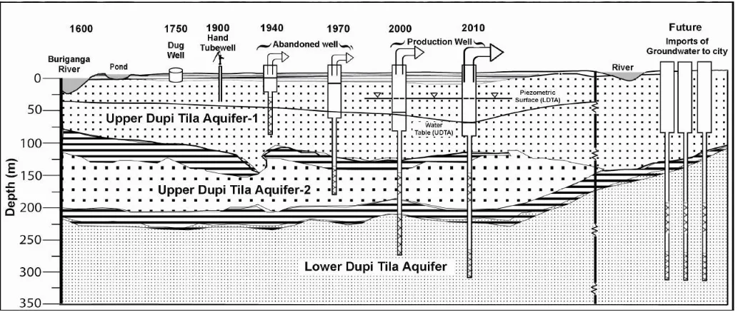
All the surface water sources are polluted in such a way that they are not usable anymore and on the other hand microorganism is another issue in surface water. In this situation people/authority have no other choice than to use groundwater. At first wells were drilled at the Upper Dupi Tila Aquifer 1 for groundwater supply. After decades a considerable part of this aquifer has become dewatered because of excessive abstraction (Hoque et al. 2007). Consequently new generation of wells were drilled in the Upper Dupi Tila Aquifer 2 which has been distributing water since 1980s (Ahmed et al. 2010). Due to rapid decline in the water level and very little natural recharge to the Upper Dupi Tila Aquifer, production wells were becoming abandoned. At the end of last century the deepest water supply wells were drilled at a depth beyond 300m and abstraction started from the Lower Dupi Tila Aquifer and will continue water supply for next decades (Figure 3).
VIII. PRESENT STATUS OF GROUNDWATER RECHARGE
As the Dhaka City is located adjacent to distributaries of the gigantic Ganges-Brahmaputra-Meghna River system, so induced recharge is possible through the Buriganga River bed (Darling et al. 2002). However prior to large scale abstraction of groundwater, the aquifer could be regarded as 'leaky confined' as Madhupur clay layer retards vertical recharge of rain water infiltration and horizontal recharge through seepage of streams (Hasan et al. 1999; Ahmed et al. 1999; Hoque et al. 2007). But following intensive abstraction over large parts of the city, the piezometric level of the aquifer has dropped about 30 m and the aquifer has become unconfined. Hence the resulting 'cone of depression' is supposed to be causing the infiltration of river water to the aquifer. Present study shows that the surrounding rivers might have a significant role in the aquifer recharge which are mainly negative in terms of entrance of contaminated river water into the fresh water aquifer.
Constructions along river banks are barring full recharge of groundwater in the monsoon and are mainly responsible for siltation which continuously hindering the natural groundwater recharges from rainfall and perennial water sources existing in and around the city. Present land development practices in the swampy areas, deposition of city garbage in the low land and natural khal and other water bodies have reduced groundwater recharge. Leakage from urban water supply and sewerage systems is likely to augment overall recharge (Lerner 1997), and urban leakage in Dhaka is thought to be extensive (EPC/MMP 1991). For instance 25-35% recharge comes from urban recharge (Rahman 2003). The north-south trending depressions on the east and west side of the city act as a natural recharging funnel to the aquifer. But thick organic layer on depressions is reducing the rate of infiltration. The western part of the city is more or less open which is favorable for vertical recharge. Groundwater recharge mechanism of Dhaka city is complex and has not yet been well understood and needs to be explored.
IX. DECLINE OF GROUNDWATER LEVEL
Groundwater is generally preferred as a source of potable water in the developing countries like Bangladesh because of its availability and natural protection from contamination (Hoque 2007). Statistics from Dhaka Water and Sewerage Authority (DWASA) show that in the 1970s the groundwater table was at 11.3 m below the surface and at 20 m in the 1980s (Table III). Up to 2000 groundwater level dropped 1-1.5 m annually. But after that over exploitation of groundwater resulted 3-5 m drop down of water table per year. In 2009 water table was 67 m below the ground surface. Groundwater level dropped 30+ m in only 10 years (2001-2009) indicating the high magnitude of groundwater extraction (Figure 4). At present the depletion rate is about 2.5-3.5 m/year (DWASA, IWM 2008).
TABLEIII
GROUNDWATER LEVEL IN DHAKA CITY(SOURCE:BADC)
Year GWL (m) Year GWL (m)
1996 27.60 2003 46.24
1997 28.15 2004 50.60
1998 30.45 2005 57.42
1999 31.86 2006 59.72
2000 34.18 2007 61.18
2001 37.78 2008 64.27
2002 42.00 2009 67.12
International Journal of Emerging Technology and Advanced Engineering
Website: www.ijetae.com (ISSN 2250-2459, ISO 9001:2008 Certified Journal, Volume 6, Issue 6, June 2016) [image:6.612.49.290.125.294.2]53
Figure 4: Graphical representation of declination of groundwaterlevel over last years (1996-2010) in Dhaka city.
The total groundwater abstraction rates by DWASA and Private Wells have been increasing with time with a linear trend. Before 1989 the volume of water withdrawal from the aquifer was 160–186 MCM/year.
But after 1990 this volume increased drastically from 264 MCM in 1990 to 592 MCM in 2003 (Hoque et al.
2007) (Table IV). This abstraction scenario is almost identical in the six distribution zones, except zone 2, where abstraction is increasing slightly less over time.
Upper Dupi Tila is almost dried up and Lower Dupi Tila (deeper) Aquifer has piezometric level at 18.08 m from ground surface (Hossain et al. 2007). Due to water table drop down more than 15% deep tube well defunct each year. To cope up with the situation, DWASA installing more wells in deeper aquifers (Figure 3). The number of wells increased more than 700% from 1970 (49 wells) to 2003 (389 wells).The frequency of installation of new tube wells has been increased since 1990. Most of the DWASA production wells were installed after 1995. Considering profound negative impact of over exploitation of groundwater, DWASA planned to reduce dependency on groundwater up to 50% by 2015.
TABLEIV
QUANTIFICATION OF GROUNDWATER ABSTRACTION IN TERMS OF CONTRIBUTION FROM RECHARGE AND STORAGE (HOQUE ET AL 2007)
Year range
Total abstraction
(MCM)
Yearly average abstraction
(MCM)
Dewatered volume of
aquifer (MCM)
Yearly average dewatered volume of aquifer (MCM)
Dewatered Pore-volume
(MCM) (for porosity
15%)
Yearly average dewatered
pore-volume (MCM)
Yearly average abstraction
from recharge
(MCM)
Yearly average abstraction
from recharge
(%)
Yearly average abstraction
from storage
(%)
1984–1988 1012.88 202.58 40.98 8.20 6.15 1.23 201.35 99.39 0.61
1989–1993 1320.60 264.12 164.09 32.82 24.61 4.92 259.20 98.14 1.86
1994–1998 1929.98 386.00 547.75 109.55 82.16 16.43 369.56 95.74 4.26
1999–2002 2173.00 543.25 2272.01 568.00 340.80 85.20 458.05 84.32 15.68
*MCM= Million cubic meter
TABLEV
WATER TABLE MONITORING DATA IN DHAKA CITY(SOURCE:BWDB)
Well ID Area Latitude Longitude Screen depth (m) Measuring height from PWD (m) GWT below surface (m)
1990 2000 2010
GT2608001 Cantonment 23.83 90.42 44.20 7.16 11.81 26.42 27.40
GT2616005 Dhanmondi 23.74 90.37 41.46 7.57 7.84 39.81 66.46
GT2642009 Lalbagh 23.72 90.41 52.83 7.41 17.44 34.90 42.31
GT2648010 Mirpur 23.79 90.37 42.48 7.47 14.65 32.77 66.64
GT2650011 Mohammadpur 23.75 90.37 34.75 7.59 17.25 20.98 37.62
GT2650012 Mohammadpur 23.76 90.36 30.92 9.32 15.46 24.31 32.60
GT2654013 Motijheel 23.73 90.42 10.42
GT2654014 Motijheel 23.75 90.42 22.76
GT2668019 Sabujbagh 23.75 90.43 56.3 7.27 21.20 37.88 52.59
GT2668020 Sabujbagh 23.73 90.44 51.83 5.22 17.10 40.11 62.80
GT2672017 Savar 23.87 90.31 32.93 9.67 6.86 7.31 9.12
GT2672018 Savar 23.92 90.31 57.30 10.47 7.75 10.32 16.85
International Journal of Emerging Technology and Advanced Engineering
Website: www.ijetae.com (ISSN 2250-2459, ISO 9001:2008 Certified Journal, Volume 6, Issue 6, June 2016)54
Bangladesh Water Development Board (BWDB) established a network of groundwater monitoring wells throughout the country. There are 13 monitoring wells within Dhaka city and adjoining areas where groundwater level is monitored weekly. Most of these wells were constructed before 1985. Groundwater table data of 20 years starting from 1990 to 2010 was used for this research (Table V). Analysis shows that in 2000 groundwater level dropped down more than 40 m in different parts of Dhaka but south-east and south-west were affected most. Two developing cone of depression was observed in the western part of the city (2000) (Figure 5).
[image:7.612.71.547.280.569.2]One side of the cone of depression was connected to the river Buriganga. Another significant 25+ m groundwater table depletion was emerged in 2010 compared to 2000 with groundwater table depletion rate of 2.5 m/year. Similar pattern is observed, adverse impacts mostly seen in south-east and south-west part; western part as well (Figure 5). Cone of depressions developed further towards contaminated Buriganga River and also in other directions. Notably, Groundwater level in northern portion of the city is still at safe depth below the surface.
Figure 5: Groundwater level of Dhaka city in 2000 and 2010.
X. CHANGES IN GROUNDWATER CHEMISTRY AND OTHER
RISKS OF EXCESSIVE GROUNDWATER ABSTRACTION
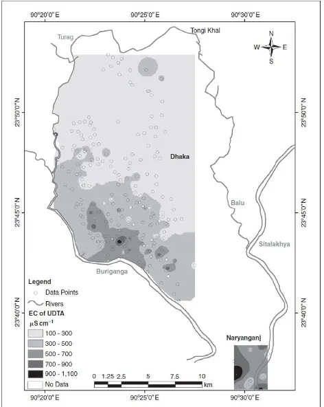
In Dhaka city the shallow aquifer is highly vulnerable to groundwater contamination. Expansion of Dhaka has been accompanied by industrialization mainly in south-western and south-central parts of the city. Electrical conductivity distribution map (Figure: 6) shows a sharp change in EC value in southern part of the city. The EC of shallow groundwater adjacent to Buriganga River ranges from 900-1000 µS/cm.
International Journal of Emerging Technology and Advanced Engineering
Website: www.ijetae.com (ISSN 2250-2459, ISO 9001:2008 Certified Journal, Volume 6, Issue 6, June 2016)55
[image:8.612.51.287.238.534.2]Moreover excessive abstraction of groundwater may result land subsidence due to compaction of clay particles and other grains in the central part. Subsidence or compaction may change the aquifer properties, ultimately destroy the aquifer. A recent study shows that land subsidence in Dhaka city will be 6.4 cm from 2000 to 2020 (DWASA & IWM, 2008). Declining groundwater level will greatly increase the risks during earthquakes.
Figure 6: Groundwater Electrical Conductivity distribution map of Dhaka.
XI. CONCLUSION
This research correlates between the trend of groundwater level declination and magnitude of over abstraction of groundwater. Pattern of water level change in the city largely follows the rate and spread of abstraction. Hydraulic gradients reversed towards the pumping centers or area of massive groundwater abstraction producing two cone of depressions in the western part of the city adjacent to Buriganga River.
Increasing nature of the groundwater abstraction and lack of appropriate understanding of the groundwater system, in terms of resource utilization, are major
limitations to the effective management of groundwater resources and constraints for sustainable groundwater development in the Dhaka city. Vertical recharge from industrial areas has reached to its maximum in polluting the aquifer in most parts of the city. On the other hand, fault controlled rivers around the metropolis would have a link with the aquifer in the region to establish localized hydraulic equilibrium by surface and groundwater interaction. Rivers around the city as well appear to be recharging the aquifer in response to pumping, establishing hydrodynamic equilibrium and contaminating groundwater eventually.
REFERENCES
[1] Ahmed, K.M. (1994). The hydrogeology of the Dupi Tila Sand aquifer of the Barind Tract, NW Bangladesh. PhD Thesis. University College London, University of London (unpublished).
[2] Ahmed, K.M., Hassan, M.K., Burgess, W.G., Dottridge, J., Ravenscroft, P., van Wonderen, J.J. (1999). The Dupi Tila quifer of Dhaka, Bangladesh: Hydraulic and hydrochemical response to intensive exploitation, In: Chilton, P.J. (ed.) Groundwater in the Urban Environment: Selected City Profiles, Balkema, Rotterdam. [3] Ahmed K.M; Haque M.M; Haque M.A; 2007. Declining
groundwater level and aquifer dewatering in Dhaka metropolitan area, Bangladesh: causes and quantification; Hydrogeol J 15: 1523–1534.
[4] Begum, D. A. and Ahmmed, K. M. Tanvir (2010) Water Quality Aspects in and around Dhaka City, Proc. of International Conference on Environmental Aspects of Bangladesh (ICEAB10), Japan, Sept. 2010
[5] Darling WG, Burgess WG, Hasan MK (2002) Isotopic evidence for induced river recharge to the Dupi Tila aquifer in the Dhaka urban area, Bangladesh
[6] DWASA (2008). Management Information Report for the month of May 2008, Dhaka Water Supply and Sewerage Authority, Dhaka, Bangladesh.
[7] DWASA and IWM (2008) Final report, Resource assessment study Part 2.
[8] EPC/MMP (1991) Dhaka region groundwater and subsidence study, Dhaka WASA, EPC in association with Sir MacDonald and Partners, Dhaka.
[9] Haq, K.A. (2006). Water Management in Dhaka. Water Resources Development 22(2): 291–311 (DOI: 10.1080/07900620600677810). [10]Hasan, M.K., Ahmed, K.M., Burgess, W.G., Dottridge, J.,
Asaduzzaman, M. (1998). Limits on the sustainable development of the Dupi Tila aquifer, Bangladesh, In: Hydrogeology in a changing environment, Volume II, British Geological Society, p.186-194. [11]Hasan, M.K. (1999). The vulnerability of the Dupi Tila aquifer,
International Journal of Emerging Technology and Advanced Engineering
Website: www.ijetae.com (ISSN 2250-2459, ISO 9001:2008 Certified Journal, Volume 6, Issue 6, June 2016)56
[12]Hoque M. A., Hoque, M.M., Ahmed, K.M. (2007). DecliningGroundwater Level and Aquifer Dewatering in Dhaka Metropolitan Area, Bangladesh: Causes and Quantification, Hydrogeology Journal, Springer-Verlag, DOI. 1007/s10040-007-0226-5
[13]Khandoker, R.A. (1987). Origin of elevated Barind-Madhupur Areas, Bengal basin results of neotectonic activities. Bangladesh Jour. of Geology, 6: 1-7.
[14]Lerner, D.N. (1997). Too much or too little: Recharge in Urban Areas, Ground water protection and Restoration. In: Chilton, P.J. (ed.) Ground Water in Urban environment: Problem, Process and Management, Bakema, Rotterdam (ISBN 9054108371).
[15]Miah, M.M, and Bazlee, B.I. (1968), Some aspects of the Geo -morphology of the Madhupur Trcat, Oriental Geographer, Dhaka. p. 39-48.
[16]Morris BL, Seddique AA, Ahmed KM (2003) Response of the Dupi Tila aquifer to intensive pumping in Dhaka, Bangladesh. Hydrogeol J 11:496–503
[17]Rahman, A.T.M.A. (2003). Present status of surface water and groundwater condition in Dhaka city. Wrkshop on „Water Resources Management and Development in urban areas with special reference to Dhaka city‟, Goethe Institute, Dhaka, Sunday, September 14, 2003.
[18]Rajdhani Unnayan Katripakha (RAJUK), 2009. Preparation of Detailed Area Plan for DMDP Area:Final Report. Dhaka: RAJUK. [19]Sarmin Sultana (2009) Hydrogeochemistry of the Lower Dupi Tila
Aquifer in Dhaka City, Bangladesh
[20]World Health Organization. (2004). Guidelines for Drinking-water Quality, 3rd Ed: Volume 1 – Recommendations. Geneva.