GPS and GSM based Passenger Tracking System
Dalip
Department of Information Technology, MMEC, Maharishi Markandeshwar University,
Mullana, Haryana, India
Vijay Kumar,
Ph.DDepartment of Computer Science and Engineering, MMEC, Maharishi Markandeshwar University,
Mullana, Haryana, India
ABSTRACT
Evolution in transportation technology makes the necessity for increasing passenger safety. Today women safety is more important when they are travelling in public transport. So we want a tracking system for passengers so that we can monitor at anytime from anywhere. Mostly passenger tracking systems are Radio Frequency Identification (RFID) based but they are not cost effective. In this paper a cost effective Global Positioning System (GPS) and Global System for Mobile communication (GSM) based passengers tracking system inside buses is introduced here. It tracks the passengers by using ticket number and displays location on Google map.
Keywords
GPS, GSM, SMS, Ticket Number, Google map.
1.
INTRODUCTION
Mostly vehicle tracking systems are based on GPS and GSM. Short Messaging Service (SMS) [1] is a feature available on all mobile phones which allows a small amount of text to be sent between one user and another. GPS consists of a [3] network of 24 satellites in six different 12-hour orbital paths spaced so that at least five are in view from every point on the globe. Today, GPS has a [2] [3] wide range of other applications including tracking package delivery, mobile commerce, emergency response, exploration, surveying, law enforcement, recreation, wildlife tracking, search and rescue, roadside assistance, stolen vehicle recovery, satellite data processing, and resource management. CELL PHONES become [10] more ubiquitous in our daily lives, the need for context-aware applications increases. One of the main context information is location, which enables a wide set of cell phone applications including navigation, location-aware social networking, and security. Automatic vehicle tracking (AVL) is a system [6] that provides the tracking of vehicle. Location Based Service (LBS), Navigation and Intelligent Transportation are the hot research topics now. Daily millions of passengers travel in buses to reach his/her destination. A major concern is the family members who wish to monitor to each other when they are moving in buses. For passengers safety point of view a passenger tracking system is required. Which can track of passengers between source and destination? Mostly passenger tracking system use RFID tags for tracking. But these tracking systems are not cost effective. So a cost effective system is introduced here by using GSM and GPS, which track passengers those are inside buses. It tracks passengers on the basis of bus ticket number. Only users need to enter the valid ticket number of passengers. Users of the system can track passengers at anytime and anywhere by using mobile phone and laptop/desktop. The users of this system can get location information of passenger, only if they know ticket number. For this tracking system its duty of passengers to tell your
ticket number to his/her known and family members before starting journey.
The rest of paper explained as follow. The section II described the related work for GPS and GSM based passenger tracking system. Section III shows proposed system. The section IV describes the conclusion of the paper.
2.
RELATED WORK
vehicle is ticketed. It can also track the vehicle’s current location on a Google Map, which is mostly beneficial when vehicles should follow a specific road and in case of robbery. Some sensors attached to the air-bags in vehicles, are attached to the system that in case of accident, it will send notifications to the civil defense, nearest hospital and police station. An efficient automotive [15] security system is implemented for anti-theft using an embedded system occupied with a GPS and a GSM. The client interacts through this system with vehicles and determines their current locations and status using Google Earth. The user can track the position of targeted vehicles on Google Earth. Coordinates of GPS are corrected using a discrete Kalman filter. An integrated GPS-GSM system [12] also use Kalman filter to enhance the accuracy of measured position. After data processing, Google Earth application is used to view the current location and status of each vehicle. This objective of this system is to manage fleet, police automobiles distribution and car theft cautions. Due to some criminal activities Parents always worry about the possibility of kidnapping of their children. Android based solution [17] to aid parents to track their children in real time. It takes the advantage of the location services provided by mobile phone since most of kids carry mobile phones. The mobile application use the GPS and SMS services found in Android mobile phones.
Some other several authors [13] [9] also have described GPS and GSM based vehicle tracking system.
3.
APPLICATION DEVELOPMENT
The application is designed for passengers and who want to track passengers. Both must have mobile phones that Support GPRS and SMS. The application is mostly to be used passengers tracking users to track down the passenger’s location. This section provides a more detailed description of the overall system and functionality of the main components of the proposed architecture. The system modal is designed in a way so that it provides the maximum accessibility for the users at anytime from anywhere by providing two types of end user applications, a mobile application and web application. In figure 1 GPS and GSM device are placed on buses. GPS device receives coordinate information from satellites. GPS device is also connected with GSM device and send the GPS coordinate information using SMS to administrator control area with the help of GSM tower. The system consists of two sides, passengers and tracking user’s side. A tracking users device main duty is to send a request ticket number SMS to the server to get the location of the passenger. On the other hand, the passenger’s device main responsibility is to reply the ticket number to his/her known before starting journey. When the users request location from the mobile and web application after registering and logging into web server, web server response corresponding user’s request.
Figure1: Passenger Tracking System
All vehicle navigation and ticket number information is stored in database. Ticket number is unique ID for all tracked passengers. Server and database are connected to each other.
this information is stored by transportation department in data base corresponding to the particular buses ID and route. The input for the system is ticket number. Users of this system can
GPS
SATELLITE
GPS + GSM
Coordinate
s
Server Database
ADMINISTRATOR CONTROL
GSM Tower
Passenger Tracking
Request/
Response
SMS
3.1
DATABASE
From the client point of view data can be stored locally or acquired from the server. Data can be hold in a database, sent by devices or transferred from other data servers. Overview of database is given below. Table 1 shows route wise history of vehicle navigation. This information is obtained by using GPS and GSM devices. The values of latitude, longitude, data,
time and speed parameters are sent by SMS to server using GSM modem. Server automatically stores this information into database. Table 2, table 3 and table 4 shows route wise ticket number corresponding to bus ID. Table 5 contains the history of passenger navigation. Every ticket number represents unique passengers inside buses.
Table1: History of vehicle navigation.
Bus ID Route Bus Stops Latitude Longitude Date Time Distance
Covered
Speed
HR001AB YnrtoDelhi Radur 30.0320932 77.1485051 1-6-2014 5:08AM 23 Km 45km/hr
HR002AB YnrtoDelhi Ladwa 29.9955086 77.0488128 1-6-2014 7:30PM 30 Km 50km/hr
HR003AB YnrtoDelhi Karnal 29.7192979 76.9819346 1-6-2014 9:00AM 4 Km 55km/hr
HR011CD AmbtoChd Ambala 29.6797275 76.9904825 2-6-2014 2:00PM 15 Km 40km/hr
HR022CD AmbtoChd Chandigarh 29.6797275 76.9904825 3-5-2014 3:40PM 30 Km 75km/hr
HR033EF PantoDelhi Sonipat 28.9243676 77.1011065 5-5-2014 8:35AM 45 Km 64km/hr
HR044EF PantoDelhi Delhi 28.9243676 77.1011065 8-5-2014 9:10AM 28 Km 70km/hr
Table 2: Route1 (YnrtoDehli)
Bus ID Ticket No.
HR001AB HR0986345AS
HR001AB HR0986346AS
HR001AB HR0986347AS
HR002AB HR0996335AS
HR002AB HR0996336AS
HR002AB HR0996337AS
Table3: Route2: (AmbtoChd)
Bus ID Ticket No.
HR011CD HR0886355AF
HR011 CD HR0886355AF
HR011 CD HR0886355AF
HR022 CD HR0876355AF
HR022 CD HR0876355AF
HR022 CD HR0876355AF
Table4: Route3(PantoDelhi)
Bus ID Ticket No.
HR033EF HR0386325AG
HR033 EF HR0386326AG
HR033 EF HR0386327AG
HR044 EF HR0486317AG
HR044 EF HR0486318AG
[image:3.595.46.540.438.559.2]HR044 EF HR0486319AG
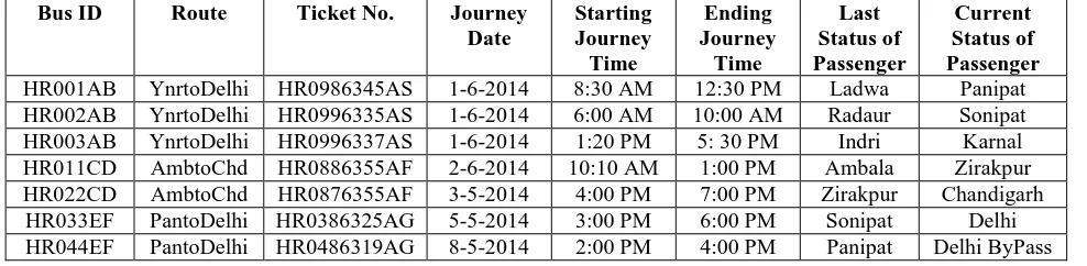
Table 5: History of Passenger Navigation
Bus ID Route Ticket No. Journey
Date
Starting Journey Time
Ending Journey
Time
Last Status of Passenger
Current Status of Passenger
HR001AB YnrtoDelhi HR0986345AS 1-6-2014 8:30 AM 12:30 PM Ladwa Panipat
HR002AB YnrtoDelhi HR0996335AS 1-6-2014 6:00 AM 10:00 AM Radaur Sonipat
HR003AB YnrtoDelhi HR0996337AS 1-6-2014 1:20 PM 5: 30 PM Indri Karnal
HR011CD AmbtoChd HR0886355AF 2-6-2014 10:10 AM 1:00 PM Ambala Zirakpur
HR022CD AmbtoChd HR0876355AF 3-5-2014 4:00 PM 7:00 PM Zirakpur Chandigarh
HR033EF PantoDelhi HR0386325AG 5-5-2014 3:00 PM 6:00 PM Sonipat Delhi
HR044EF PantoDelhi HR0486319AG 8-5-2014 2:00 PM 4:00 PM Panipat Delhi ByPass
3.2
RESULTS AND DISCUSSION
Figure 2: Tracking with Ticket Number
Figure3: Display Passenger Tracking Information
Figure 5: Distance covered by Passenger on Google Map [18]
The input for the system is ticket number as shown in figure 2. In figure 3 after enter valid ticket number it shows passenger tracking information. It also displays the location on Google map. Figure 4 shows passenger at Radaur city on Google map. Figure 5 represents how much distance is covered by passenger. The proposed system is cost effective because no any other costly devices are required for tracking, except Bluetooth enable GPS receiver and GSM mobile phone.
4.
CONCLUSION
In conclusion, this project was developed to aid locating passengers. Proposed passenger tracking system is efficient in term of system cost. This system tracks the passengers on the basis of vehicle history and ticket number. It provides the history of passenger movement and displays location on Google map. Tracking is easy for the users of this system because they just need to enter the valid ticket number only. Features can be added to enhance the system such as Geo-fencing, emergency alerts and many others.
5.
REFERENCES
[1] SMS Quick Start Guide, “Changemakers Ashoka innovators for the public”, Arilington, VA 22209-1929 USA. www.changemakers.com
[2] P. Enge and P. Misra, “Special issue on GPS: The global positioning system,” Proc. IEEE, vol. 87, no. 1, pp. 3–15, Jan. 1999.
[3] Rashmi Bajaj, Samantha Lalinda Ranaweera and Dharma P. Agrawa,” GPS: Location Tracking Technology”, Communication, April 2002.
[4] Andrei Gurtov, Matti Passoja, Olli Aalto And Mike Raitola,Multi-Layer Protocol Tracing in a GPRS Network ,IEEE Fall VTC 2004: 124-130.
[5] Shah, D., Patel, D., Chaudhary and S,” Grid-Based Vehicle Locating System”, pp. 53–67. Springer, Heidelberg (2006).
[image:4.595.53.291.72.283.2]hybrid model “,Proceedings of the IEEE International Conference on Automation and Logistics Qingdao, China September 2008.
[8] Ali Mousavi, Mohammad A. Rajabi, and Mohammad Akbari, “Design and Implementation of a GSM Based Automatic Vehicle Location System “,ICCSA , Part I, LNCS 5592, pp. 533–542, © Springer-Verlag Berlin Heidelberg 2009.
[9] Khondker Shajadul Hasan, Mashiur Rahman, Abul L. Haque, M Abdur Rahman, Tanzil Rahman and M Mahbubur Rasheed,” Cost Effective GPS-GPRS Based Object Tracking System”, Proceedings of the International MultiConference of Engineers and Computer Scientists Vol I IMECS 2009, March 18 - 20, 2009, Hong Kong.
[10] Mohamed Ibrahim and Moustafa Youssef,” CellSense: An Accurate Energy-Efficient GSM Positioning System“, Ons On Vehicular Technology, Vol. 61, NO. 1, © 2011 IEEE.
[11] Bashir Shalaik and Adam Winstanley,” Delivering Real-Time Bus Tracking Information on Mobile Devices”, J.J. Park, L.T. Yang, and C. Lee (Eds.): FutureTech 2011, Part II, CCIS 185, pp. 139–147, © Springer-Verlag Berlin Heidelberg 2011.
[12] Mohammad A. Al-Khedher,” Hybrid GPS-GSM Localization of Automobile Tracking System”, International Journal of Computer Science & Information Technology (IJCSIT) Vol 3, No 6, Dec 2011.
[13] Iman M. Almomani, Nour Y. Alkhalil, Enas M. Ahmad, Rania M. Jodeh,” Ubiquitous GPS Vehicle Tracking and Management System”, 2011 IEEE Jordan Conference on
Applied Electrical Engineering and Computing Technologies (AEECT), 978-1-4577-1084-1/11/$26.00 ©2011 IEEE.
[14] Xianyong Feng, Karen L. Butler-Purry and Takis Zourntos,” Multi-Agent System-Based Real-Time Load Management for All-Electric Ship Power Systems in DC Zone Level”, 0885-8950/$31.00 © 2012 IEEE.
[15] Montaser N. Ramadan, Mohammad A. Al-Khedher and Sharaf A. Al-Kheder,” Intelligent Anti-Theft and Tracking System for Automobiles “,International Journal of Machine Learning and Computing, Vol. 2, No. 1, February 2012.
[16] Saed Tarapiah, Shadi Atalla and Rajaa AbuHania,” Smart On-Board Transportation Management System Using GPS/GSM/GPRS Technologies to Reduce Traffic Violation in Developing Countries “, International Journal of Digital Information and Wireless Communications (IJDIWC) 3(4): 96-105, ISSN: 2225-658X, 2013.
[17] A. Al-Mazloum, E. Omer, M. F. A. Abdullah,” GPS and SMS-Based Child Tracking System Using Smart Phone”, World Academy of Science, Engineering and Technology, International Journal of Electrical, Electronic Science and Engineering Vol:7 No:2, 2013. [18] Google Map APIs. [Online] Available at