Study of Tsunami Vulnerability of Junglighat and
Surrounding Areas using Remote Sensing and GIS
Vishnu Manoj1, Dr. K Dharanirajan2 Dr. A. Janarthana Boobalan 3Ashwini Kumar Rabidas4 Anand Rao5 1,3
Department of civil engineering, Indian institute of science Bangalore, India
2,4, 5
Department of Disaster Management, Pondicherry University, India
Abstract: Tsunami, an ever-present threat to lives and property along the coasts of most of the world's oceans 1. They are considered as a secondary hazard along with earthquake or volcanic eruption archives 2 Andaman Island was badly hit by gigantic waves of the 2004 Sumatran tsunami, thousands of people lost their lives and vital infrastructures were destroyed. Epicentre of the 2004 Sumatran earthquake was hundreds of miles away from Junglighat. Junglighat and its surrounding area are having a large number of populations along the coastal line. The objective of this study is to find vulnerable zones and mitigate the impact of disasters at the time of Tsunami in Junglighat and its surroundings. Geographic Information System (GIS) and Remote sensing are important tools to prepare thematic maps as it incorporates the elevation data and delineate the extent of tsunami inundation areas to locate potential hazard zones 3. To identify the regions that can be affected from tsunami attack an inundation maps of coastal areas should be made. Tsunami risk analysis helps to manage future development planning and to diminish the loss 4
Keywords: Disaster, Mitigation, Junglighat, GIS and Remote Sensing
I. INTRODUCTION
Tsunami is a series of pressure wave caused by a sudden shift in the ocean 5. Such shifts are usually caused by earthquakes, but they can also be caused by undersea landslides or slumps, volcanoes, or even meteor impacts. They are one of the most destructive natural hazards that affect the coastal areas 6. The tsunami of 26 December 2004 was a major natural disaster, killing some 229 866 men, women and children and causing large scale damage 7 With a magnitude of 9.1 to 9.3, the earthquake that caused the tsunami was the largest in the last forty years and second largest in instrumental history 8. These incidents remind us about the importance of integration of disaster management and development planning. Disaster management should be the base of sustainable development. Coastal area development should be carried only after a proper analysis of existing situation & vulnerability assessment of the area under consideration. Andaman Island is situated in a highly seismic active area 9. Threat from earthquakes and tsunamis are always there at doorsteps of Andaman isles10. 2004 Sumatra earthquake produced ~1.0 m of subsidence in some parts of Andaman isles 11. Because of extensive development, population growth and greater use of the coastal zones, Island’s vulnerabilities to earthquake and tsunami hazards have dramatically increased. Analysis of multi-sensor temporal satellite data of pre and post-earthquake period for six months around Island revealed that north western part of the Island belt experienced emergence of landmass while part of Little Andaman and islands of Nicobar group, major parts of South Andaman suffered submergence. Further study after major earthquake, established that the south eastern part suffered further submergence due to post-earthquake readjustment and uplifted north-western part of the Andaman-Nicobar Island belt experienced reverse changes while the central part of the belt remained stable 12. A post-tsunami analysis of soils of mangroves of the Andamans showed higher levels of saturation in Na and Mg and marked reductions in
microbial biomass13. Among the coastal ecosystems, the coral reefs suffered maximum damage with Nicobar reefs, 29% degraded
and 69% eroded. Bearing the brunt, 22% degraded Mangroves on both the groups of islands were impacted due to uprooting and inundation of seawater leading to stagnation and more than 54% of the Andaman reefs eroded. Conversion of acid soils to saline acid soils and acid sodic soils to acid saline sodic soils have been reported in South Andaman14 Above studies show an intense earthquake or a gigantic tsunami like 2004 can affect Andaman and Nicobar very badly. It tells us about the need for vulnerability assessment in low lying areas like Junglighat.
II. STUDY AREA
because of the geographical position of island. But lack of proper knowledge about tsunami and absence of a sea wall increased the damage. This area is having an elevation range from 1m to 95m above sea level.
Fig 1: Areal view of study Area
III. MATERIALS & METHODOLOGY
The following materials were used to carry out this study. Image processing software ERDAS IMAGINE 9.1 and GIS software ARC GIS10.1 were used to process the image and geospatial analysis for the Tsunami impact studies. For the field survey hand held GPS were used
S.NO Spatial data Year Scale/Resolution Source
1 SOI Toposheet 1979 1:500000 Survey of India
2 Resource SAT-2 2013 5 meters LISS IV
3 Google earth image 2016 - Google earth
A. Methodology
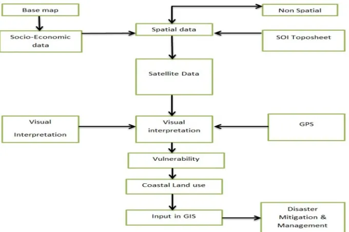
[image:3.612.123.463.488.714.2]The satellite data were interpreted based on the visual interpretation keys like tone, texture, size, shape, pattern, association etc. as per the classification system given by space application centre 15. Contour map was prepared using SOI Toposheet. Vulnerability map was prepared from contour map. The real time impact assessment was made with the help of above maps and accuracy was verified by detailed field surveys. The low lying Junglighat and surrounding area were selected for this study. Land use and land cover map was prepared with the help of satellite image and then individual buildings were identified. Then vulnerability map was prepared with respect to contour lines as high, medium, low zones and suitable management measures were suggested.
IV. RESULT
[image:4.612.118.492.232.501.2]Different zones based on elevation data have been identified in study area. Area with an elevation of 0-10m was identified as highly vulnerable zone, 10m-15m as moderately highly vulnerable zone, 15-20m as moderately vulnerable zone, 20-25m as less vulnerable zones and other areas were identified as safer zones. Construction activities had been carried out in highly vulnerable zone.
Fig 3: Land use map of study area
Total number of buildings in this area has been estimated as 2140 with help of Google earth software and field study. Among this, nearly 300 buildings are made of tin or wood. These structures are really fragile to tsunami.
TABLE I
Total number of buildings 2140
Tin buildings 168
Wooden buildings 110
RCC building with concrete roof 1466
[image:4.612.140.470.598.714.2]With the help of handheld GPS, few important buildings from different vulnerable zones are identified. Details about them are given in the following table. Following table indicates the lack of proper urban planning.
TABLE 2
Presence of school, community halls, and religious places attracts large mass to vulnerable areas. School is having strength more than 500. Even though school is having a disaster management plan evacuation of school children will be tough task at the time of disaster.
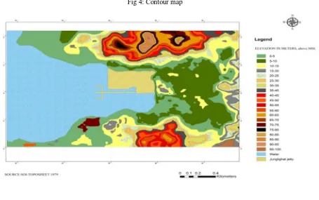
Fig 4: Contour map
Contour map was digitized from the toposheet at an interval of 5m from mean sea level. It starts with zero value and end with 100m. The highest height value is 100m. From the contour map, it was observed that a good portion of the area fall under 20m height. It was prepared by using software ARCGIS. After analyzing these maps, vulnerable areas were identified. Since it is an island, the area between high Tide Line and 20m contour was taken as a vulnerable area 16. From analysis, it was found that fisher man’s colony and lower parts of Prem nagar were vulnerable area.
Name of the feature Highly vulnerable zone Medium vulnerable zone
School 1 0
Quarters 20 20
Community hall - 2
Religious place 6 3
Play ground 1 -
Fish market 1 -
Market 3 5
Shops 20 6
Hotel 5 1
Jetty 1 -
Fig 5: Vulnerability map: 0 to10m-highly vulnerable zone, 10m-15m-moderately highly vulnerable zone, 15-20m-moderately vulnerable zone, 20-25m-less vulnerable zones and other areas were identified as safer zones
V. OTHER MITIGATION MEASURES
A. Retreating From Potential Inundation Zones
A sudden retreat from potential inundation zones is almost impossible. Besides, increasing population and less land resources has pressurized poor to occupy the vulnerable zones. A major portion of land mass were occupied by forests, steep slopes, defence peoples etc. Another possible way is to adopt different mitigation methods.
B. Accommodating The Risk
Even though there is a high level of tsunami-related risk Coasts are tend to be areas of high economic activity. It won’t be feasible to stop and transfer all activities beyond inundation zones17 Instead there may be a need to accommodate the risk by the adoption of non-structural or structural measures. Any physical construction to reduce or avoid possible impacts of hazards, or the application of engineering techniques or technology to achieve hazard resistance and resilience in structures or systems are considered as structural measures while non-structural measures doesn’t involve any physical construction which use knowledge, practice or agreement to reduce disaster risks and impacts, in particular through policies and laws, public awareness raising, training and education.
A. Structural Measure
1) Building codes: Most of the buildings constructed along the coastal line are not strong enough to resist possible huge pressure from tsunami. Tin houses and wooden houses will increase the damage. The development and application of design guidance and building codes for tsunami-resistant housing is a part of mitigation18. From previous experiences, we have learned that the perfectly designed structures will withstand the impacts of tsunami with only limited damage. But cost may be an impediment to tsunami-proofing structures. Deeper scour-resistant foundations and flow-through basement designs are mandatory in areas of high risk
3) Channel/ Nala Gates: This is one of the most important tasks for reducing the effect of Tsunami. Because most of the channel / Nalas (small rivulets) and other water bodies in the region connected to sea as part of drainage system. Through these channels, water can easily enter to residential areas. To avoid this bad situation construction of Channel/ Nala gates reduce the impact of
Tsunami1
4) Tsunami forests: This acts as a wall to tsunamis and it had already been implemented in Sri Lanka. This is one of the best natural way to avoid tsunami effect, and the best way to create the natural barrier 20. This is constructed depending on the vulnerability of the area. Based on the environment, width and length is decided. But in area under consideration chances of having an effective artificial tsunami forest is very less because of the presence of Junglighat jetty but still it can be planted in other parts
5) Artificial Reef: Artificial reef is an underwater man-made structure, typically built for the purpose of promoting marine. Artificial reefs may serve to improve hydrodynamics and control beach erosion21. Artificial reefs can be built in a number of different methods. Many reefs are built by deploying existing materials. This can be done by sinking oil rigs (through the Rigs-to-Reefs program), scuttling ships, or by deploying rubble, tires, or construction debris etc. Reefs can play a vital role in decreasing speed of waves.
B. Non Structural Measures
1) Zoning: One of the most important non Structural Measures is zoning22.Vulnerable Zoning enables governments at various levels, typically local or regional, to set restrictions on the types of structures that can be built in various locations within their jurisdictions. This tool can be used to prevent critical infrastructures such as power plants and hospitals from being built in tsunami or storm surge inundation risk zones.
2) Warning Systems: This is another essential non-structural mitigation activities in developing an effective warning system23 Warning system should be powerful enough to reach the grass root level in minimum time. A proper warning system will help to reduce causalities. Water level, location of the property or infrastructure, the elevation and real-time conditions of tide-gates are key elements of a tsunami surge warning system24. Establishing detection and warning systems are particularly relevant to tsunami policy. A timely warning will help people to move to safer zones.
3) Education and proper training : One main reason behind the large number of loss of lives in 2004 tsunami is that a large population were not aware of the destructive power of tsunami25. It is obvious from many videos taken from the site before attack took place, where most people were running toward sea when water started retreating. In school curriculum now tsunami hazards and effects are added. Proper training should be given to the local community about the emergency situation and how they can protect themselves. Proper training imparts the guidelines about how they can help the affected society.
VI. CONCLUSION
In an Island like Andaman and Nicobar, low lying coastal areas are always under threat from tsunamis. They cannot be prevented but the impacts can be reduced. Proper understanding about the disaster will help to reduce the impact of disasters. Research and monitoring should be motivated in such areas. Dissemination of collected information to local community on real time basis is having outmost importance. The Human life can be saved by having monitoring system. Developmental and constructional activities should be carried out at coastal regulatory zone regulations. Remote sensing technologies can be exploited in creating a wealth of relevant information about remote areas and generating an integrated decision support system (DSS) to decision makers. It is expected that developing an integrated decision support system would enable policy makers to have a better understanding about the linkages between regional and global processes. The damage over highly sensitive critical habitats can be easily identified by remote sensing and GIS technology. Various required mitigation measures like structural and nonstructural measures can be easily identified using remote sensing and GIS technique. This mitigation measures will be helpful to protect the people, property and environment from future disasters
REFERENCES
[1] Mercalli, G. Vulcani e fenomeni vulcanici in Italia; Francesco Vallardi: Milano, Italy, 1883.
[2] Baratta, M. II Vesuvio e le sue eruzioni. Dall’anno 79 d.C. al 1896; Società Editrice Dante Alighieri: Roma, Italy, 1897
[3] Dharanirajan, K., Pandian, P. K., Gurugnama, B., Narayanan, R. M., Ramachadran, S. 2007. An Integrated Study for the assessment of Tsunami Impact: a case study of Andaman Island, India using remoting sensing and GIS. Coastal Engineering Journal 49 (3): 229-266
[5] floor Nizam, H. 2005. Some lessons from the Aceh tsunami: hydraulic aspects of housing arrangement. International Symposium on Disaster Reduction on Coasts, 14–16 November 2005, Melbourne, Australia
[6] Cummins, P. R. 2007. The potential for giant tsunamigenic earthquakes in the northern Bay of Bengal. Nature, Vol. 449, pp. 75–78
[7] United Nations, 2007 United Nations, 2007. “The Human Toll”. UN Office of the Envoy for Tsunami Recovery. http://www.tsunamispecialenvoy.org/country/ humantoll.asp. Accessed 15 May 2007
[8] Bilham, 2005 Bilham, R., 2005. A flying start, then a slow slip. Science 308: 1126
[9] Johnston, D., Pat?n, D., Crawford, G. L., Ronan, K., Houghton, B. & B?rgelt, P. 2005 Measuring tsunami preparedness in coastal Washington, United States. Nat. Hazards 35, 173-184. Special Issue, US National Tsunami Hazard Mitigation Program, (doi: 10.1007/sl 1069-004-2419-8).
[10] Chadha, R. K., Latha, G., Yeh, H., Peterson, C. and Katada, T., 2005. The tsunami of the great Sumatra earthquake of M 9.0 on 26 December 2004 - impact on the east coast of India. Current Science 88(8): 1297-1301.
[11] Bahuguna et al. (2008Bahuguna, A., Nayak, S. and Roy, D., 2008. Impact of the tsunami and earthquake of 26th December 2004 on the vital coastal ecosystems of the Andaman and Nicobar Islands assessed using RESOURCESAT AWiFS data: Internat.Jour.App.Earth Observ. & Geoinformation, v. 10 (2), p. 229-237
[12] Das and Pramanik, 2011Das, D.P. and Pramanik, K., 2011. Evaluation of impact of earthquake and tsunami on the coastal morphology of Andaman – Nicobar Island using multi-sensor temporal satellite data: Indian Jour. Geosci., v. 65 (1), p. 9-22
[13] Chaudhuri et al. 2009Chaudhuri, G.S., Dinesh, R., Sheeja, T.E., Raja, R., Jeykumar, V. and Srivastava, R.C., 2009. Physico-chemical, biochemical and microbial characteristics of soils of mangroves of the andamans: A post-tsunami analysis: Current Science, v. 97 (1), p. 98-102
[14] Nayak et al.2010 - Nayak, A.K., Damodaran, T., Singh, C.S., Jha, S.K., Raja, D., Mishra, V.K., Sharma, D.K. and Singh, G., 2010. Post tsunami changes in soil properties of Andaman Islands, India: Environ. Monitor.and Assess. v. 170 (1-4), p. 185-193.
[15] SAC 1992
[16] Dharanirajan, K., Pandian, P. K., Gurugnama, B., Narayanan, R. M., Ramachadran, S. 2007. An Integrated Study for the assessment of Tsunami Impact: a case study of Andaman Island, India using remoting sensing and GIS. Coastal Engineering Journal 49 (3): 229-266.
[17] Jelínek, R. and Krausmann, E. 2009: Approaches to tsunami risk assessment, EUR 23573 EN, JRC48713, Luxembourg (Luxembourg): OPOCE, 50 pp. [18] Designing for Tsunami, National Tsunami Hazard Mitigation Programme Steering Committee, March 2001, NOA, USGS, FEMA, NSF, Alaska, California,
Hawaii, Oregon and Washington.
[19] Papadopoulos, G.A. and Dermentzopoulos, Th. 1998: A Tsunami Risk Management Pilot Study in Heraklion, Crete, Natural Hazards 18: 91–118. [20] Keith Forbes (2007 Keith Forbes and Jeremy Broadhead. 2007. The role of coastal forests in the mitigation of tsunami impacts, Food and Agriculture
Organization of the United Nations Regional Office for Asia and the Pacific, Bangkok.
[21] Mohan Krishan, Disaster Management Action Plans for State of Maharashtra: A Review of its unique components
[22] Dharanirajan, K., Pandian, P. K., Gurugnama, B., Narayanan, R. M., Ramachadran, S. 2007. An Integrated Study for the assessment of Tsunami Impact: a case study of Andaman Island, India using remoting sensing and GIS. Coastal Engineering Journal 49 (3): 229-266.
[23] Mandal, G. S. 1999. Forecasting and Warning Systems for Cyclones in India, Shelter, October, 1999, pp. 24-26.