Technology (IJRASET)
Estimation of Conveyance Pace in Urban
Environment Using Kalman Algorithm
Ms.Anuradha P1, Deepa V2, Devi Shankari P3, Ponnarasi C4 1
Assistant professor-I, 2,3,4Student , Department of Information Technology, Prathyusha Engineering College, AnnaUniversity ,Thiruvallur, India
Abstract--Vehicle speed is desirable for application such as Driving safety, driving behavior, traffic condition etc. In general if the speed is accurate then the application is said to be effective. In the project, we use Smartphone sensors to determine the vehicle speed especially in the situation when GPS is unavailable or inaccurate in urban environment. The vehicle speed is determined by integrating the accelerometer readings. We introduce an accurate vehicle speed in urban environments including making turns, stopping, and passing through uneven road surfaces to derive reference points and further eliminates the speed estimation deviations caused by acceleration errors.Accident is quite common, so this application is designed to detect the accident ,when accident occurs it automatically captures the image and audio, and also tracks the location information then sends as an sms and email to the pre-registered email and phone number.
Keywords--Accelerometer,Accidentdetection,Audio,GPS,Image.
I.INTRODUCTION
Generally, the vehicle speed is obtained with the help of GPS. However, GPS embedded in smart phones cause low availability and accuracy in the urban environment. Besides, the low update rate of GPS is not able to keep up with the frequent change of the vehicle speed in urban driving environments. Additionally, continuously using GPS quickly drain the phone battery. Thus, it is hard to estimate the speed of the vehicle accurately for applications requiring real-time or high accuracy speed determination. Our system uses sensors in Smartphone’s, i.e., accelerometers to calculate the error in the acceleration and with the help of the acceleration reading we should estimate the speed. This approach is standard in different turn sizes and driving speeds. While the method of estimate the acceleration reading over time seems simple, a lot of problems arise in practice. First, the reading from the accelerometer are noisy and these noise should affected by numerous driving environments. Second, the estimation of speed should be real-time and accurate. Finally, the solution for this problem should be easy and the result should be achieved on the Smartphone’s .our application also detect the accident tracking. Because in today world all of them having a Smartphone so this is the one advantage to made this Smartphone based accident tracking system. Smartphone-based accident detection applications provide several advantages relative to the normal existing vehicle accident detection systems, e.g., first, they are independent of vehicle, the analysis of data be very effective about accident. Smartphone in a wireless mobile sensor network can store the lot of information data given by the accelerometers and GPS sensors.
II. EXISTING SYSTEM
In existing system the speed of the vehicle should be estimated with the help of traffic cameras and loop detectors. in consideration of real-time we should estimate the vehicle speed by OBD-II on-board diagnostics. It is a popular type of interface used to determine the speed. Then GPS is used to determine the speed. However the existing system requires so much of cost for the determination of speed. By using GPS continuously the phone battery drains.
A. Disadvantages
Installation cost is high.
High maintenance cost in urban environment. GPS drains the battery quickly.
III. PROPOSE WORK SYSTEM
Technology (IJRASET)
accelerometer and orientation. The acceleration error should be measured with the help of the reference point and the errors should be eliminated to obtain the speed of the vehicle. Here we use the algorithm Kalman Algorithm to filter the noise and accelerations errors to give accurate readings. In addition to that ,the application also track the accident location. In general the accident occur in the road play the major part of the injury, deaths around the world. With the help of the application we should identify the accident ,the information should passed to the pre-registered number so the saving time of person should be more. so we easily help the person to recover easily , this avoid major injuries. Over the past decade, automatic traffic accident system used as a important objective in the area to track the accident and send the SMS and email to the pre-registered number.If the accident occur then the phone transfer the accident location to the registered number and send the current situation image, audio via e-mail..
A. Why Accident Detection Is Important?
The accident detection is important because there are so many of them lost their life in the car accident. Lot of people get injured due to the car accident. Car accident plays a major role in the today world. It is not possible to avoid car accident at some point but we have a chance to rescue the life of the person. This application rescue the persons life. This application is the cheap and best application for the people.
B. Advantage
Accelerometer readings are accurate and not affected by coarse grained signal. Cost effective.
IV. ARCHITECTURE
Figure 1 Architecture diagram
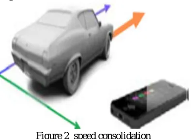
A. Speed Consolidation
Technology (IJRASET)
are reduced so we get the accurate accelerometer value. with help this accelerometer reading obtain the speed. The speed of the vehicle should be measured because the speed denote the vehicle condition, the vehicle move fast, moderate or high speed. The speed of the vehicle in control then the vehicle accident should be reduced. the algorithm explanation should be followed as: Input X, Y ,Z values of accelerometer
Xk = Fk(xk−1) + Bk(uk) + Wk
Fk -Is the accelerometer value of the previous state(xk−1).
Bk -Is the control input which is being applied to the control vector uk Xk -Is the accelerometer estimated by the algorithm
Wk -Is the noise which is removed from Xk
[image:4.612.216.413.206.350.2]OUTPUT: accelerometer value after removing noise.
Figure 2 speed consolidation
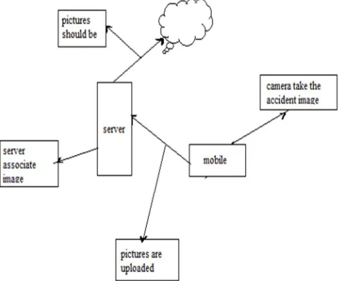
B. Accident Tracking
Accident tracking is the additional feature in this project we have. Every day around the world, a large number of people die from traffic accident injuries.nowadays we use Smart phone to detect and transfer information about the traffic accidents. The accident detection using Smartphone now only become possible due to the improvement in the processing power and sensors embedded in the smart phones. In the project when the mobile is shakes in a particular angle (the force is applied to the phone) then it is considered as accident detection and the front camera is triggered automatically and captures the pictures. In addition to that the audio of the surrounding is captured in order to know the current situation of the accident and transmitted to the cloud server. The cloud server sends these captured audio and photo to the guardian of the person through mail and sends the current location of the accident through SMS (Short Messaging Services).The messages which are transferred through various medium are encrypted for privacy us and can be decrypted only by the authenticated person’s only. Here the server act a main role because the stored information about the pre-registered number and phone number in order to send the accident information at the correct time. Here we notice one point the shake of the mobile considered as the accident these activity is carried out by the orientation sensor. The work of the orientation sensor is to detect the triggering action. In real time we have these two sensors in mobile phone the accident should be identified when the threshold value reach the maximum value. By this way we should track the accident.
[image:4.612.202.439.557.701.2]Technology (IJRASET)
C. Geolatitude Tracking
[image:5.612.212.415.295.507.2]The GPRS is used to transmit the location information of the accident to the central system monitoring. The Users longitude and latitude positions are provided by the Global Positioning System .The accident exact Zone is tracked by the monitoring system using the GPS. After tracking of location, Immediately the location information should be sent to the pre-registered number through SMS.We can register the nearby hospital numbers, traffic police numbers etc instead of guardian number ..so they can come quickly to the zone and take certain actions and avoid death rate. This saves the time between the accident occurs and ambulance arrives to the exact aaccident location. The GPS is a space based radio- navigation system consisting of the network for ground station network which is used for monitoring and controlling the system. The Department of Defence (DOD) is used to maintain and operate the GPS. The GPS is a constellation of satellites in an orbit around the earth which transmit the time and position of the space. The GPS is a receiver that collects the location information all around the world through the satellites. we invoke the GPS(Global Positioning System) function in the android device which establishes the function using the location manager, the location is tracked by the device. The exact latitude, longitude can be detected by the device. The U.S department of defence placed a network of 24 satellites in an orbit which is called a GPS. The GPS was first intended to the military applications but in the year 1980s,it was also used for the civilian purpose. GPS can work 24 hrs in a day and in any climatic conditions all around the world. For the use of GPS, there is no subscription fees or any separate setup. The GPS is a simple and efficient way for the users to use for tracking the current positions information.
Figure 4 Location tracking
D. Forwarding Notification Services
A notification service provider means to send a notice too many persons at a time.The forwarding notification is one of the most important way to transfer the information of the current user . The information of the location, audio and image are saved in the database server or the cloud server. The cloud server sends these captured audio and pictures to the pre-registered persons email. Then the location information as a message to the registered number .The working of forwarding notification service working if any accident occurring is identified the captured image and audio should be first transmitted to the server from the server the details are send to the registered emails. The main advantage of the system is the current position of the persons should be identified and for that we have to take the safety measures. The basic idea of the forwarding notification service is to give information about person after the accident. What will be the current position of the person should be identified with the help of the notification service. This will surely help the doctors to do their first aid and treatment to the person. For example if no notification involved then the accident location only send means there is no use because the condition of the person could not obtained for the first aid purpose and treatment.
Technology (IJRASET)
Figure 5 Forwarding Notification
V. APPLICATION
The Car accident detection is an very useful application for wireless mobile sensor networks. The advances in processing power and versions are making it possible to detect car accidents in a more portable and cost effective manner .we should know the procedure of the application and use of the application. With help of the application what are the accidents to be captured.. After installing this application we have to register our details by giving our name, phone number, e-mail id and password. as well as during registration the guardian number and the emailed of the guardian must be included which is used during any emergency purposes. After giving this detail then click to the register button then, we can use the application by logging in using email-id and password. The email id and the password must be same as the registered thing .After entering the app the speed of the vehicle should be estimated. In future we can also use the nearby general hospital phone numbers and the general traffic police numbers, and the police station numbers, etc as the pre-registered number. Then we can log in to the application, it starts showing the speed of the vehicle. The speed is accurate even in the sudden stops or in case of uneven road surfaces or during a making turns. The speed of the vehicle can be calculated accurately when the GPS is unavailable or in case of inaccurate . Then if any accident occurs the Smartphone immediately track the location and captures the image and audio of the persons current position and sends an message to pre-registered numbers. This is the working process of the application. The drawback of the system is if no network is available then the information should be transferred to the pre-registered number. But in future we do not have the network problem because of the huge development in the technology.
VI. CONCLUSION
Here we should give the solution to the problem when the GPS is unavailable or at the urban environment we should use the accelerometer to calculate the value of speed. That calculation speed is also accurate as such as GPS. The speed of the vehicle should be estimated at the stop, turning and travel through the uneven roads. Because in urban environment the roads should be uneven. We have the additional feature in the application is that accident tracking that also be useful application to the society to avoid more number of death and injuries of the people.
VII. FUTURE ENHANCEMENT
Technology (IJRASET)
REFERENCES[1] J. Levinson and S. Thrun, “Robust vehicle localization in urban environments using probabilistic maps,” in Proc. IEEE Int. Conf.Robot. Autom., 2010, pp. 4372–4378.
[2] F. Chausse, J. Laneurit, and R. Chapuis, “Vehicle localization on a digital map using particles filtering,” in Proc. Symp. Intell. Veh. 2005, pp. 243–248. [3] Y. Wang, J. Yang, H. Liu, Y. Chen, M. Gruteser, and R. P. Martin“Sensing vehicle dynamics for determining driver phone use,” inProc. ACM 11th Annu. Int.
Conf. Mobile Syst., Appl. Serv., 2013, pp. 41–54.
[4] J. White, C. Thompson, H. Turner, B. Dougherty, and D. C.Schmidt, “Wreckwatch: Automatic traffic accident detection andnotification with smartphones,” Mob. Netw. Appl., vol. 16, no. 3,pp. 285–303, Jun. 2011.
[5] J. Paefgen, F. Kehr, Y. Zhai, and F. Michahelles, “Driving behavioranalysis with smartphones: Insights from a controlled fieldstudy,” in Proc. ACM 11th Int. Conf. Mobile Ubiquitous Multimedia,2012, pp. 36:1–36:8.
[6] D. Johnson and M. Trivedi, “Driving style recognition using asmartphone as a sensor platform,” in Proc. IEEE Int. Conf. Intell.Transportation Syst., 2011, pp. 1609–1615.
[7] P. Mohan, V. N. Padmanabhan, and R. Ramjee, “Nericell: Richmonitoring of road and traffic conditions using mobilesmartphones,” in Proc.6th ACM Conf. Embedded Netw. Sens. Syst.,2008, pp. 323–336.
[8] T. N. Schoepflin and D. J. Dailey, “Dynamic camera calibration ofroadside traffic management cameras for vehicle speedestimation,” IEEE Trans. Intell. Transportation Syst., vol. 4, no. 2,pp. 90–98, Jun. 2003.
[9] A. Gorski. understanding gps performance in urbanenvironments. [Online]. Available: http://blogs.agi.com/agi/2011/01/04/understanding-gps-performance-in-urbanenvironments/,2011.