An Implicit Three-Dimensional Meteorological Message
for Artillery Trajectory Calculation
by Patrick A. Haines, David J. Epler II, James L. Cogan, Sean G. O’Brien,
Benjamin T. MacCall, and Brian P. Reen
ARL-TN-0584 November 2013
NOTICES Disclaimers
The findings in this report are not to be construed as an official Department of the Army position unless so designated by other authorized documents.
Citation of manufacturer’s or trade names does not constitute an official endorsement or approval of the use thereof.
Army Research Laboratory
White Sands Missile Range, NM 88002-5501ARL-TN-0584 November 2013
An Implicit Three-Dimensional Meteorological Message
for Artillery Trajectory Calculation
Patrick A. Haines, David J. Epler II, James L. Cogan, Sean G. O’Brien,
Benjamin T. MacCall, and Brian P. Reen
Computational and Information Sciences Directorate, ARL
REPORT DOCUMENTATION PAGE Form Approved
OMB No. 0704-0188
Public reporting burden for this collection of information is estimated to average 1 hour per response, including the time for reviewing instructions, searching existing data sources, gathering and maintaining the data needed, and completing and reviewing the collection information. Send comments regarding this burden estimate or any other aspect of this collection of information, including suggestions for reducing the burden, to Department of Defense, Washington Headquarters Services, Directorate for Information Operations and Reports (0704-0188), 1215 Jefferson Davis Highway, Suite 1204, Arlington, VA 22202-4302. Respondents should be aware that notwithstanding any other provision of law, no person shall be subject to any penalty for failing to comply with a collection of information if it does not display a currently valid OMB control number.
PLEASE DO NOT RETURN YOUR FORM TO THE ABOVE ADDRESS.
1. REPORT DATE (DD-MM-YYYY)
November 2013
2. REPORT TYPE
Final
3. DATES COVERED (From - To)
August–September 2013
4. TITLE AND SUBTITLE
An Implicit Three-Dimensional Meteorological Message for Artillery Trajectory Calculation
5a. CONTRACT NUMBER 5b. GRANT NUMBER
5c. PROGRAM ELEMENT NUMBER 6. AUTHOR(S)
Patrick A. Haines, David J. Epler II, James L. Cogan, Sean G. O'Brien, Benjamin T. MacCall, and Brian P. Reen
5d. PROJECT NUMBER 5e. TASK NUMBER 5f. WORK UNIT NUMBER 7. PERFORMING ORGANIZATION NAME(S) AND ADDRESS(ES)
U.S. Army Research Laboratory
Computational and Information Sciences Directorate Battlefield Environment Division (ATTN: RDRL-CIE-M) White Sands Missile Range, NM 88002-5501
8. PERFORMING ORGANIZATION REPORT NUMBER
ARL-TN-0584
9. SPONSORING/MONITORING AGENCY NAME(S) AND ADDRESS(ES) 10. SPONSOR/MONITOR’S ACRONYM(S) 11. SPONSOR/MONITOR'S REPORT NUMBER(S)
12. DISTRIBUTION/AVAILABILITY STATEMENT
Approved for public release; distribution is unlimited.
13. SUPPLEMENTARY NOTES
14. ABSTRACT:
It has been shown that the inaccuracy of meteorological (MET) information used accounts for the majority of artillery error. With MET data now being obtained from Numerical Weather Prediction (NWP), artillery inaccuracy is partially due to suboptimal utilization because the currently used single-column single-time MET profile (Computer Meteorological Message [METCM]) does not account for horizontal variation of the weather over the range of an artillery trajectory. Increased artillery targeting accuracy is expected when three-dimensional (3-D) MET information is used instead of a METCM. Moreover, operational artillery situations sometimes occur in which the midpoint location of an artillery trajectory is at an elevation well above that of the gun and the target. This necessitates a large extrapolation of the surface data at the message location that may not provide a good representation of the conditions near the gun or near the target area. An implicitly 3-D message is proposed that includes some of the horizontal variation of weather, but preserves the METCM format. It also mitigates the problems associated with extrapolation of data by reducing the height interval over which extrapolation is done.
15. SUBJECT TERMS:
meteorological, artillery trajectory
16. SECURITY CLASSIFICATION OF: 17. LIMITATION OF ABSTRACT
UU
18. NUMBER OF PAGES
18
19a. NAME OF RESPONSIBLE PERSON
Patrick A. Haines a. REPORT Unclassified b. ABSTRACT Unclassified c. THIS PAGE Unclassified
19b. TELEPHONE NUMBER (Include area code) (575) 678-5593
Standard Form 298 (Rev. 8/98)
iii
Contents
List of Figures iv Acknowledgements v 1. Introduction 1 2. Background 2 3. Calculation Procedures 4 4. Summary 7List of Symbols, Abbreviations, and Acronyms 8
List of Figures
Figure 1: Artillery trajectory over a mountain located at the trajectory midpoint. ...3 Figure 2: Calculation of MET parameter value, ψM, at a zone midpoint, ZM. It is calculated
v
Acknowledgments
I would like to thank Jessica Camunez for so patiently listening to my fairly incoherent
explanation of figure 2 to her. This really helped me discuss it considerably more clearly in the report. I also would like to thank Sherry Larson for her superb technical editing of the report.
1
1. Introduction
Analysis of live-fire artillery impacts and observational meteorological (MET) data has shown that inaccuracy of meteorological information accounts for about 65% of artillery error.1
Meteorological inaccuracy affects both range and deflection. It is due to disparities between the time and location where MET data was measured and the time and location where it was used and is also due to instrumentation errors in the MET equipment. MET data is now obtained from Numerical Weather Prediction (NWP) and time staleness of forecast data (i.e., differences between the time the NWP forecast is valid and the time it is being applied) has been virtually eliminated in the United States (U.S.), but inaccuracy of MET due to forecast error and suboptimal utilization of available data continue to be artillery error issues.
“Current gun artillery systems can deliver projectiles to ranges above 20 km. Longer barrels together with base-burn/rocket projectiles and stronger charge systems with muzzle velocities up to almost 1000 m/s extend the firing ranges up to 40 km. At these ranges, the MPI [mean point of impact] error (accuracy) significantly reduces the effectiveness of the gun fired artillery weapon system, so much so that significant numbers of rounds are required to achieve the required target effect.”2
Suboptimal utilization of NWP forecasts occurs because the currently used column single-time MET profile (Computer Meteorological Message [METCM]) does not account for weather variability with space and time.3 To reduce inaccuracy due to time evolution of the atmosphere, numerical weather prediction is now used to generate METCMs every 30 minutes, but a single-column message is only valid at a single position while the atmosphere can have appreciable horizontal variation even over the range of an artillery trajectory. Therefore, we expect increased artillery targeting accuracy when three-dimensional (3-D) MET information, which includes the horizontal variation of the winds, temperature, pressure and moisture along an artillery trajectory as in a Gridded Meteorological Message (METGM) is used instead of a METCM.4
1Standardization Agreement (STANAG) 4635; North Atlantic Treaty Organization (NATO) Standardization Agency (NSA);
The NATO Armaments Error Budget, 2008.
2Refer to page 2 in reference 1; STANAG 4635.
3Standardization Agreement (STANAG) 4082; North Atlantic Treaty Organization (NATO) Standardization Agency (NSA);
Adoption of a Standard Artillery Computer Meteorological Message, Edition 2, 1969.
4Standardization Agreement (STANAG) 6022; North Atlantic Treaty Organization (NATO) Standardization Agency (NSA);
In addition to failing to consider horizontal variation of weather conditions, the operational artillery sometimes encounters situations in which the midpoint location of an artillery trajectory (where the single-column METCM is generated) is at an elevation well above that of the gun and the target. A large extrapolation of the surface data at the message location is then required to provide MET information for the entire trajectory calculation, and the MET data near the surface at the midpoint may not provide a good representation of the conditions near the gun or near the target area. A METGM message would address all these concerns, but is currently not used by the U.S.
To address some of these deficiencies an implicitly 3-D message is proposed. It will include more information than a conventional METCM by implicitly incorporating some of the
horizontal variation of weather, but the end result will be a single profile in the METCM format. It will also mitigate the problems associated with extrapolation of data by reducing the height interval over which extrapolation is done. Meanwhile, the trajectory calculation will proceed exactly as if a conventional METCM were used.
2. Background
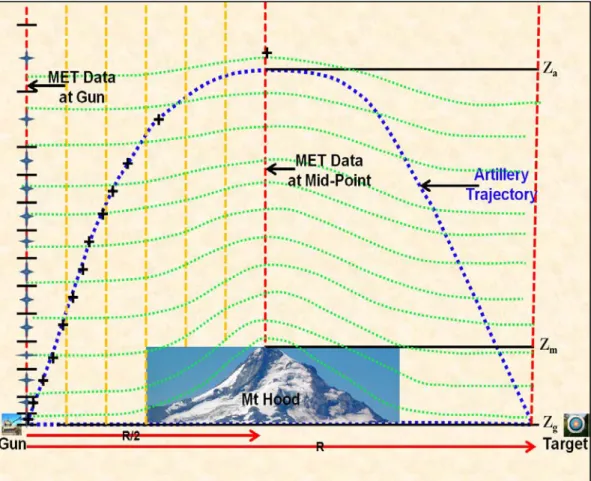
Figure 1 shows an artillery trajectory that passes over a mountain or intervening terrain. The distance from the gun to the target is designated by the arrow of length R (R stands for the artillery range) at the bottom of the figure. Just above this is another arrow of length R/2 that is the distance between the gun and the trajectory midpoint. The heights, Za, Zm, and Zg, are
respectively the height of the trajectory apogee, the height of the ground surface at the trajectory midpoint and the height of the ground surface at the gun. Also shown are dashed vertical red lines above the gun midpoint and target locations. These represent conventional artillery messages at their respective locations. The numerical model grid columns along the ascending part of the trajectory are shown by the mustard-colored vertical columns. The model has a terrain conformal vertical coordinate (example model vertical levels are shown by the dashed green lines) in order that the model calculations take into account the effect of the underlying terrain on the airflow above it. Note that the vertical spacing between vertical model grid points increases with height.
3
Figure 1. Artillery trajectory over a mountain located at the trajectory midpoint.
The message zone structure of a conventional message is shown by the short black horizontal lines along the gun location vertical column that indicate the edges of the message zones and the blue symbols, which indicate the zone midpoints. The corresponding zone midpoints along the dashed blue artillery trajectory are shown by the black “+” symbols. As an artillery projectile moves horizontally and vertically along its trajectory its path passes through the NWP grid field. The most accurate MET data for any particular trajectory calculation point would be obtained by interpolation of the MET data immediately surrounding a calculation point; this is impossible using the conventional message. In the implicitly 3-D approach proposed here, the NWP data that is used corresponds to the zone midpoint heights and positions along the trajectory path. This approach requires a reasonable a priori trajectory path to use in calculating the horizontal and vertical coordinates of the zone midpoints.
For a conventional METCM, the MET data in the four model columns surrounding a message location are used to generate the message. In contrast, the implicitly 3-D message’s MET data is drawn successively from the four columns surrounding the horizontal location along the
trajectory associated with a given message zone midpoint height.Calculation of these locations is given in the next section of this report. The guiding principles of the hybrid message formation are as follows. First, the data above the gun are most appropriate to trajectory calculation in the
vicinity of the gun. Similarly, MET data above the midpoint are the most appropriate data for trajectory calculation in the vicinity of the midpoint. Next, between the gun and target, the MET data closest in proximity to where the trajectory intersects each message zone midpoint are the best for calculating the trajectory. Finally, because the MET data near the target has a smaller effect on artillery accuracy in artillery trajectory calculation than MET data near the gun and midpoint, and to fulfill the objective that the message looks exactly as a conventional METCM, the model MET data between the midpoint and the target is not used. An even better way to calculate the trajectory would draw upon data in the close vicinity of trajectory points, from a 3-D database, in a point-by-point manner, as the trajectory is calculated (as is possible with a METGM).
3. Calculation Procedures
The message’s MET Datum Plane (MDP) corresponds to the model terrain height at the gun location. The message’s 32 zones (0–31) are then set up with respect to the MDP in the same way as in a conventional METCM, so for example, zone 0 is the surface, 0–200-m above ground level (AGL; where ground level is defined as the MDP) is zone 1, 200–500-m AGL is zone 2, and zones 3–11 are all 500 m thick extending from 500- to 5000-m AGL. Zones 12–26 are all 1000 m thick and extend from 5000- to 20,000-m AGL. Finally zones 27–31 are all 2000 m thick and extend from 20,000-to 30,000-m AGL.3 A zone’s MET parameter values are for its midpoint so, for example, they would be at 5500-m AGL for zone 12.
In order to find the height z at each point along an artillery trajectory we approximate the trajectory with a parabola centered at the apogee. Note that z is the height above the MDP. A parabolic trajectory neglects air resistance and coriolis deviation. The latter forcing will be generally less than one grid interval of the NWP MET data, while the deviation from the actual trajectory due to air resistance, when compared with the grid spacing of model MET data, will be small in the ascending part of the trajectory. Equation 1 describes this parabola and requires two values for unique specification—the range, R, and the apogee height relative to the MDP, za:
𝑧 = 𝑧𝑎− 4𝑧𝑅2𝑎�𝑥 −𝑅2� 2
(1) The solution to equation 1, which can be found with the quadratic formula, yields the distance from the gun as a function of the projectile height:
𝑥 =𝑅2 ±𝑅2 �(1 −𝑧𝑧
5
The two solutions represent the upward (negative sign) and downward (positive sign) legs of the parabolic trajectory path, which can be distinguished respectively from where x is less than or greater than R/2.
Using the above solution requires either data or an assumed value for the apogee height. Based on a number of typical trajectories, the apogee height and the range often have a simple
relationship in which the apogee height is approximately one-third of the range or,
za =R3 (3)
With this assumption, and assigning the horizontal along-the-trajectory-coordinate, x, a value of 0 at the gun, R/2 at the midpoint and R at the target, we can curve fit a parabolic projectile path as,
𝑥 =𝑅2 ±𝑅2 �(1 −3𝑧𝑅 ) (4)
By specifying the height, z, as the height of each zone’s midpoint, we can solve for the
corresponding position along the gun to target direction, x, in equation 4. The upward (negative) solution is used to determine the x location from which to extract NWP model data for a given message zone by using the message zone midpoint height as z in equation 4. The x location for METCM zones whose midpoint height is above the apogee height (i.e., z>za) will be taken at
the midpoint location (i.e., x=R/2) in the same way as for a conventional METCM. In order to account for terrain height variation along the trajectory, the height from which to extract NWP output at location x is found by subtracting from z the difference in NWP terrain height between location x and the gun location. For example, consider the case where one is determining the MET for zone 12, whose midpoint is 5500-m AGL. Assume that at the point x where the
trajectory passes through 5500 m relative to the NWP terrain height at the gun location, the NWP terrain height is 2500 m while at the gun location the NWP terrain height zg is 1000 m. The MET
extracted for zone 12 would then be the NWP solution at point x vertically interpolated to 6500 m mean sea level (MSL), or 4000 m AGL.
We recognize that for short-range, high-apogee firing, the apogee height will be quite different than one-third the range. In such a case, the MET data will be less representative of the MET along the true trajectory; however, the implicitly 3-D method will still provide more accurate MET information than would be the case if simply using the midpoint column.
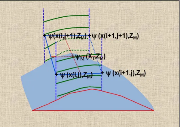
Figure 2 illustrates the calculation of a MET parameter ψM for a given message zone midpoint
height ZM, and at an x location XT along the trajectory corresponding to that zone’s midpoint
height, calculated using equation 4. First the MET parameter values at the same height MSL on the four surrounding model columns are obtained by vertical interpolation between the model vertical levels immediately above and below that height. Because the vertical coordinate is
terrain conformal, a message zone midpoint height may fall between different vertical model calculation levels on each column. The message’s midpoint value is then obtained through bi-linear interpolation of the MET parameter values (ψ) on the four surrounding model grid columns to the zone midpoint, XT.
Figure 2. Calculation of MET parameter value, ψM, at a zone midpoint, ZM. It is calculated through
vertical and then horizontal interpolation.
When the METCM message is applied to determining a firing solution, there are certain cases where MET data is required below the MDP. One such case is where the actual terrain height at the gun location is below the NWP terrain at that location. Another case is where the target height is below the NWP terrain at the gun location. In these cases a simple extrapolation is performed based on the standard atmosphere. This extrapolation is also used in current artillery meteorology systems and involves extrapolating temperature and pressure based on the standard atmosphere while allowing wind components to remain constant throughout the extrapolation layer. Because the MDP in the implicitly 3-D METCM is the NWP terrain height at the gun location rather than the NWP terrain height at the trajectory midpoint, the need for extrapolation to obtain meteorology for the first part of the trajectory should decrease. Future work will investigate the utility of using the NWP solution to perform a case-specific extrapolation rather than relying on the standard atmosphere.
7
4. Summary
This report describes the calculation of an implicitly 3-D MET message using NWP data. Instead of drawing data from one location, the implicitly 3-D message draws data from locations along a generic artillery trajectory. The resulting message has exactly the same format as the
conventional one-dimensional message and the trajectory calculation is also done the same as for a conventional message. The new message accounts for horizontal variation of MET conditions along the ascending part of the trajectory, which is the most important part with respect to artillery accuracy. It also mitigates problems associated with messages generated at an artillery trajectory midpoint that is above terrain that is much higher than that of the gun.
List of Symbols, Abbreviations, and Acronyms
3-D three-dimensional AGL above ground level MDP MET Datum Plane MET meteorological
METCM Computer Meteorological Message METGM Gridded Meteorological Message MSL mean sea level
NWP Numerical Weather Prediction U.S. United States
No. of Copies Organization 9 1 DEFENSE TECHNICAL (PDF) INFORMATION CTR DTIC OCA 2 DIRECTOR (PDFs) US ARMY RSRCH LAB RDRL CIO LL RDRL IMAL HRA RECORDS MGMT
1 GOVT PRINTG OFC (PDF) A MALHOTRA 5 DIRECTOR (PDFs) US ARMY RSRCH LAB RDRL CIE J L COGAN RDRL CIE M P A HAINES B P REEN RDRL CIE D S G OBRIEN B T MACCALL 1 US ARMY CONTRACTING (PDF) COMMAND CCAP SCA WS JESSICA R CAMUNEZ 1 US ARMY ARDEC (PDFs) FIRING TABLES AND
AEROBALLISTICS DIVISION A J SOWA 2 CGI FEDERAL (PDFs) M ZAHN D EPLER II 3 PM MATIC (PDFs) R D YOWELL J L GRAY M B STRAUSS 1 DIRECTOR MCSC (PDF) E VALLIERE