AIS Electronic Library (AISeL)
AIS Electronic Library (AISeL)
ACIS 2012 Proceedings Australasian (ACIS)
2012
Twitter Tsunami Early Warning Network: A Social Network
Twitter Tsunami Early Warning Network: A Social Network
Analysis of Twitter Information Flows
Analysis of Twitter Information Flows
Uuf BrajawidagdaBatam Polytechnic, [email protected]
Akemi Takeoka Chatfield
University of Wollongong, [email protected]
Follow this and additional works at: https://aisel.aisnet.org/acis2012
Recommended Citation Recommended Citation
Brajawidagda, Uuf and Chatfield, Akemi Takeoka, "Twitter Tsunami Early Warning Network: A Social Network Analysis of Twitter Information Flows" (2012). ACIS 2012 Proceedings. 56.
https://aisel.aisnet.org/acis2012/56
This material is brought to you by the Australasian (ACIS) at AIS Electronic Library (AISeL). It has been accepted for inclusion in ACIS 2012 Proceedings by an authorized administrator of AIS Electronic Library (AISeL). For more information, please contact [email protected].
Twitter Tsunami Early Warning Network:
A Social Network Analysis of Twitter Information Flows
Akemi Takeoka Chatfield
School of Information Systems and Technology University of Wollongong, Australia
Email: [email protected] Uuf Brajawidagda Batam Polytechnic, Indonesia
School of Information Systems and Technology University of Wollongong, Australia
Email: [email protected]
Abstract
In the aftermath of earthquakes, tsunamis, such as the 2011 Great East Japan Tsunami, caused enormous damage around the world. With the extreme disaster events of the past, nations improved disaster preparedness and response through sensors and tsunami early warning systems. Even with system usage, however, governments still need to warn the targeted citizens – who may be anywhere within the vulnerable areas – of predicted tsunami and ordered mass evacuations within a very limited lead time. While social media research is on the rise outside the domain of social networking, very little is written about Twitter use for tsunami early warning. In this research, therefore, we examined the utility of Twitter as a tsunami early warning network, which engages citizens and disaster management agencies in diffusing disaster information. We conducted a social network analysis of Twitter information flows among the central disaster warning agency’s Twitter followers during the 2012 Indonesia Earthquake.
Keywords
Twitter, tsunami early warning network, social network analysis, Indonesia’s disaster management agencies
INTRODUCTION
With the sharp rise in mobile phone penetration rate around the world, the use of social media is also dynamically accelerating because users have more options to access their social media account. This mobile access option can radically change online social interactions among people. Specifically, the way people provide information and find information on social media channels may be influenced by the easy mobile access to their social media account. Furthermore, information flows over social media channels can be captured timely and accessed directly through the user’s mobile phone.
Government agencies in emergency or disaster management such as Federal Emergency Management Agency (FEMA) in the US, Queensland Police Service (QPS) in Australia, and the Indonesian Agency for Meteorology, Climatology and Geophysics (BMKG) have been using social media for a complementary information channel for interacting with their citizens. Social media use in disaster response has been used, for example in search and rescue (Wei et al. 2012), emergency relief (Goggins et al. 2012; Ichiguchi 2011; Nugroho 2011; Palen 2008), evacuations (Ichiguchi 2011) and recovery (Lu and Yang 2011; Palen 2008). As many social media client application available for mobile phone, they provide direct access to their social media account without accessing the social media website. It means users are able to post or receive disaster related information timely from/to their mobile phone.
In the recent years, we witnessed the increased catastrophic tsunamis in the Asia Pacific region. In 2004, the Indian Ocean Tsunami hit Indonesia severely with more than 230,000 casualties not only in Indonesia but also in more than fourteen countries throughout the entire Indian Ocean. More recently, the 2011 Great East Japan Tsunami caused 15,861 casualties and contributed to the chaotic and delayed response to the Fukushima Daiichi Nuclear Power Plant accidents. Due to the serious impacts of the previous tsunamis, the vulnerable countries in the region attempt to increase their tsunami preparedness and response. One crucial preparedness phase is to inform and warn citizens about the predicted tsunami to enable their timely mass evacuations during the next phase of disaster response. For the forecasted areas to be inundated by tsunami, only a very limited lead time is available for citizen evacuations. Therefore, the availability of tsunami early warning systems is critically important to save vulnerable citizens. Despite the growing literature on social media use, little is written about if and how social media can be
used to diffuse information within a social media tsunami early warning network. In this research, therefore, we address two research questions: Does Twitter work as a tsunami early warning network? If it does, how does the Twitter tsunami early warning network diffuse tsunami warning information within a very limited time? To answer these questions, we have conducted a social network analysis of the data set of 6,383 tweets (or 82%) of all the tweets generated by the followers of the Indonesian Agency for Meteorology, Climatology and Geophysics (BMKG) Twitter tsunami early warning network for the period of 16 days from June 18 to July 3, 2012. These tweets represent the chain of information flows triggered by the first Tweet of the 4.11 2012 Indonesia tsunami. The remainder of this paper is structured as follows: Section 2 reviews the literature on early warning systems, social media use in crisis and disaster management, and social network analysis applications. Section 3 briefly introduces the 2004 Indian Ocean tsunami and Indonesia’s disaster response reform, especially tsunami early warning and a central disaster management agency. Section 4 describes the social network analysis research methodology and the data set used for analysis to address the research questions. Section 5 presents the social network analysis results. Section 6 presents our discussion and the conclusion of this study, including our research limitations and future research directions.
LITERATURE REVIEW
Early Warning Systems
Leveraging advanced information and communication technologies for lead time, natural disaster early warning systems aim to reduce the impact of natural disasters by forecasting disaster events timely and accurately, prior to
their actual occurrences have not yet been observed, to provide government agencies and/or citizens a limited lead time for disaster preparation and response. On the one hand, forecasting a disaster is critically important. In order to detect the likely occurrence of disasters, prior research has focused on advancing sensor technologies and implementing decision support systems (DSS) to predict the disaster’s likely scale, time of occurrence, location, potential impacts, and the need for mass evacuations. On the other hand, government communication of the predicted disaster to the intended audiences in a timely manner is also critically important. Citizens in the likely inundated area need to know about the approaching catastrophic disaster so as to prepare for evacuations.
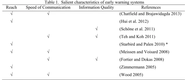
Table 1. Salient characteristics of early warning systems
Reach Speed of Communication Information Quality References
√ √ (Chatfield and Brajawidagda 2013)
√ (Hui et al. 2012)
√ (Schöne et al. 2011)
√ √ (Teh and Koh 2011)
√ (Starbird and Palen 2010) *
√ √ (Meissen and Voisard 2008)
√ √ (Fortier and Dokas 2008)
√ (Zimmermann 2005)
√ √ (Wood 2005)
*Focus on social media technologies
Prior research on early warning systems has identified at least three salient attributes of an effective early warning system. Of the studies, only Starbird & Palen (2010) focused on social media technologies. Table 1 shows the three attributes: reach (Chatfield and Brajawidagda 2013; Hui et al. 2012; Meissen and Voisard 2008; Starbird and Palen 2010; Wood 2005; Zimmermann 2005), speed of communication (Chatfield and Brajawidagda 2013; Fortier and Dokas 2008; Meissen and Voisard 2008; Teh and Koh 2011; Wood 2005), and information quality (Fortier and Dokas 2008; Schöne et al. 2011; Teh and Koh 2011). Social media provide scale and their ‘reach’ is dynamically flexible. It can be defined as the capability to reach the intended audiences, ranging from a small group of targeted high-risk community residents to a global audience of nuclear power plant operators and nuclear industry experts. Social media technologies are by their very nature decentralized and networked in form, with millions of users at multiple points of information production and consumption. In consequence, social media’s speed of communication is fast, depending on the number of active users who transmit the information without delay within their social media networks. Finally, information quality refers to accurate, complete, and clear content of the user-generated information for the intended audiences.
Social Media Use for Disaster Response
Disaster management cycle is adopted by countries in order to model and classify the activities needed in disaster response. In general, disaster management cycle consists of four phases: response, recovery, mitigation and preparation. A comprehensive disaster management cycle consists of four temporal phases: preparation (or preparedness), response, recovery, and mitigation (National Research Council of the National Academies 2007). Here the interdependence across these four linked phases and between the adjacent phase activities should be recognized. For example, what was done or rather what was not done at the preparation phase activities – prior to an extreme natural disaster event strikes local government areas – largely influences the level of government disaster response activities at the next response phase.
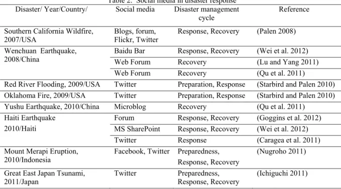
Each phase involves the management and coordination of a wide array of stakeholders: government agencies, emergency response teams, community-based non-government organizations, and local residents. Prior research on network technologies such as radio frequency identification(RFID) has provided strong support for improved management and coordination of multiple stakeholders in business contexts (Wamba and Chatfield 2009). Therefore, the management and coordination of each phase may be improved by making real-time location-aware information about people and high-value assets available through the use of network technologies. However, little is written on how social media use in the mitigation phase. The social media types used were also varies, from photosharing, blog, microblog and social networking as shown in Table 2. According to the disasters type, social media shows its usefulness during flood, fire, volcano eruption, earthquake and tsunami.
Table 2. Social media in disaster response Disaster/ Year/Country/ Social media Disaster management
cycle Reference
Southern California Wildfire,
2007/USA Blogs, forum, Flickr, Twitter Response, Recovery (Palen 2008) Wenchuan Earthquake,
2008/China Baidu Bar Web Forum Response, Recovery Recovery (Wei et al. 2012) (Lu and Yang 2011) Web Forum Recovery (Qu et al. 2011)
Red River Flooding, 2009/USA Twitter Preparation, Response (Starbird and Palen 2010) Oklahoma Fire, 2009/USA Twitter Preparation, Response (Starbird and Palen 2010) Yushu Earthquake, 2010/China Microblog Recovery (Qu et al. 2011)
Haiti Earthquake 2010/Haiti
Forum Response, Recovery (Goggins et al. 2012) MS SharePoint Response, Recovery (Wei et al. 2012) Twitter Response (Caragea et al. 2011) Mount Merapi Eruption,
2010/Indonesia Facebook, Twitter Preparedness, Response, Recovery (Nugroho 2011) Great East Japan Tsunami,
2011/Japan Twitter Preparedness, Response, Recovery (Ichiguchi 2011)
Social Network Analysis
Social network analysis (SNA) has been used in biomedical (Bales et al. 2008; Jonnalagadda et al. 2012), tourism (Baggio 2008; Ying 2010), e-government (Chung and Chatfield 2011), and disaster response (Cheong and Cheong 2011). Salient information and knowledge, such as interrelationship (Bales et al. 2008; Ying 2010), effective communication (Cheong and Cheong 2011), and behaviour of a network (Baggio 2008) can be extracted for further analysis through the analysis of nodes and their relationships. SNA describes nodes that are inter-connected by a set of relationships. In SNA, a graph is used to model a social network composed by nodes and links. While nodes represent individual actors within a social network, links represent social ties, relationships, connections, exchanges, or interactions among the actors. A social network graph enables us to visualize a vast amount of large data and complex information flows for a general overview and initial interpretations. With software tools, salient metrics of the social network can be generated from the existing nodes and links for further analysis. For example, we generated in this study: number of nodes, number of links, network density, diameter, average degree, number of weakly connected component, number of strongly connected components and average path length. The number of nodes determines the size of a social network. The strength or weakness of social ties between the nodes is represented by the number of the links. The density of a social network refers to the degree of dyadic connections in a social network, indicating how fully the network is inter-connected. The diameter of a network is the largest distance of any dyadic pair of nodes in the network. The average degree represents quantifications of average actor tendencies in connections to others in a network. While the weakly connected
component represents the number of one-way communications among the nodes, the strongly connected component represents the number of the nodes with two-way communications.
CATASTROPHIC TSUNAMI & INDONESIA’S DISASTER RESPONSE REFORM
The 2004 Indian Ocean Tsunami was a waking call for Indonesia to radically improve the nation’s disaster management, including disaster preparedness and disaster response. In order to minimize the disaster impact, especially the number of disaster casualties, Indonesia reformed its national disaster management laws and established National Disaster Management Agency (BNPB), a lead agency for disaster management, in 2008. BNPB collaborates with other government agencies for specific disaster response functions and operations. For example, with regard to climate, earthquake and tsunami detection, BNPB works closely with the Indonesian Agency for Meteorology, Climatology and Geophysics (BMKG).The BMKG is responsible for operating the Indonesia Tsunami Early Warning System (InaTEWS) to detect, analyse, simulate, and release disaster-related information on earthquake, tsunami, and bad weather. The Decision Support System (DSS) functions of the InaTEWS support decision-making processes by the following four sub-systems: 1) situation assessment system for creating earthquake maps and running simulations; 2) real-time monitoring system which employs GPS, buoys, and tide gauges; 3) decision system for suggesting the appropriate type of warnings; and 4) product system for disseminating. This four sub-system increase BMKG capability in detecting tsunami and disseminate the information to other government agencies or directly to the society. Importantly, the BMKG uses electronic media, GSM broadcaster, sirens and any other media to disseminate tsunami information to citizens. Since January 26, 2010, the BMKG used @infoBMKG as its official Twitter account for complementing the existing conventional media. As of July 2 2012, BMKG has released 6,223 Tweets with 339,871 followers.
RESEARCH METHODOLOGY
In this research, we address the research questions: Does Twitter work as an early tsunami warning system? If it does, how does the Twitter early tsunami warning system propagate tweets within a very limited time? In order to address the research questions, we conducted a network analysis of Twitter information flows within a network of Indonesia’s disaster management agencies, with regard to the 4.11 2011 Indonesia earthquake and tsunami. We conduct network analysis to describe nodes, groups and the network relationship for conveying the tsunami warnings. In this research, we apply the SNA to Indonesia’s Twitter information flows within a network of national disaster management agencies.
More specifically, the social network in this research is created by the information flows of a Tweet tsunami warning released by the BMKG. We have selected the first Tweet released by the BMKG to inform the 4.11 2012 tsunami. The Tweet was recorded on April 11, 2012 at 8:46:17 UTC, and it was ended at 13:15:06 UTC.
Figure 1: BMKG first Tweet for the 4.11 2012 tsunami warning
Figure 1 above shows the Tweet ID; 189997788396920833, which states as follows (in English translation): “Tsunami Early Warning in Bengkulu, Lampung, Aceh, West Sumatra, North Sumatra, Earthquake Mag: 8.9 SR, April 11 2012 15:38:29 West Indonesian Time, Location 2.31 LU,9 twitpic.com/98fdwn”. According to the Twitter record, this BMKG Tweet was retweeted for 7,781 times. However, Twitter limits the REST API user access especially for searching specific tweet. Therefore, we used a third party data provider, Topsy.com, for searching the propagated tweets. The search identified 6,383 tweets which contain the BMKG tsunami early warning. The 6,383 tweet data set we have collected in this research represents 82% of all the retweets available during the extreme disaster event period. Then we traced all the 6,383 tweets to Twitter to collect all the metadata available, such as when the tweet was created, the Twitter user name, who their friends are, how many followers they have, and importantly, user location information. Based on these social ties among the Twitter users, we constructed a social network. However, among the 6,383 tweets, there are 137 duplicate tweets and, therefore, the actual tweets used to construct the network were 6,246 tweets. All the data were collected for the period of 16 days from June 18 to July 3, 2012.
RESULTS
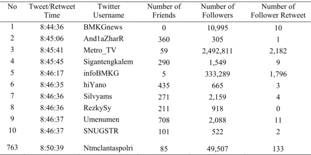
Before we analyse the information network, we analysed how fast the network responded to the first tsunami warning. Table 3 shows the first ten tweets and retweets of the first tsunami warning posted by BMKG on April
11, 2012. As shown in Table 3 below, the first Tweet informing the Tsunami was posted by @BMKGnews, at 8:44:36 UTC. When the earthquake happened at 8:38:29 UTC, there was the delay of 6 minutes and 7 seconds during which the InaTEWS might be deciding whether or not the earthquake could cause tsunami. It seemed to be a remarkably fast decision, because InaTEWS needed to collect and interpret diverse sources of information such as the earthquake epicentre data, the tide data from the buoys and earth crust deformation from the sensors deep in the sea. However, it was found that @BMKGnews was not BMKG official Twitter account. As the BMKG official website indicates, there is a link to its official Twitter account, which is @infoBMKG. @BMKGnews was still operated by BMKG since January 10, 2009, before they decided to establish their new official Twitter account, @infoBMKG. Although there was an announcement about the official account of BMKG as @infoBMKG, on the @BMKGnews front page, BMKG still maintained this former Twitter account concurrently. In consequence, this former account still had 10,995 followers as of July 3 2012. Furthermore, @BMKGnews account posted the first tsunami warning 1 minute 41 seconds earlier than that of @infoBMKG.
Table 3. The first 10 tweets and retweets of the 4.11 2012 first tsunami warning No Tweet/Retweet
Time Username Twitter Number of Friends Number of Followers Follower Retweet Number of
1 8:44:36 BMKGnews 0 10,995 10 2 8:45:06 And1aZharR 360 305 1 3 8:45:41 Metro_TV 59 2,492,811 2,182 4 8:45:45 Sigantengkalem 290 1,549 9 5 8:46:17 infoBMKG 5 333,289 1,796 6 8:46:35 hiYano 435 665 3 7 8:46:36 Silvyams 271 2,159 4 8 8:46:36 RezkySy 211 918 0 9 8:46:37 Umenumen 708 2,088 11 10 8:46:37 SNUGSTR 101 522 2 . . . . . . 763 8:50:39 Ntmclantaspolri 85 49,507 133
Table 3 above shows that the first tsunami warning Tweet posted by @BMKGnews was retweeted by 10 of its followers. One of the followers is @Metro_TV, a leading national television channel with 2,492,811 followers. Among its follower, 2,182 (or 0.09%) of the total followers then retweeted the tsunami warning Tweet to their followers. Among the first 10 Tweets, 7 of them are ordinary citizens, with number of follower retweets ranging from 0 to 11. All the ordinary citizens had 522 to 2,159 followers. Based on the number of followers, there are 4,428,864 followers who receive the first 10 Tweets. Another government agency, @ntmclantaspolri, retweet at 8:50:39, with the delay of 12 minutes 10 seconds after the earthquake and the delay of 6 minutes 3 seconds after the @BMKGnews first tweet.
Figure 2: Number of retweets after the BMKG first tsunami warning during the warning period
Figure 2 above shows all the tweets drawn into a timeline. The x axis on this bar graph shows time, whereas the y axis shows the actual number of retweets during the tsunami early warning period on April 11, 2012. As is shown in Table 3 above, the BMKG posted its first Tweet tsunami warning at 8:44:36, which is shown at the left-side of the x axis on this bar graph. The followers of the BMKG Tweet then retweeted the agency’s tsunami early warning to their own follows. The bar graph shows that the number of retweets was accelerating fast and then
reached the peak within five minutes of the BMKG Tweet. The bar graph also shows that the highest number of retweets per second is 13 which lag behind the BMKG Tweet a little over 4 minutes later. The number of retweets fluctuates from 3 to 9 per second until 9:15:00 UTC when 30 minutes passed since the BMKG posted its first tsunami early warning Tweet. The information flows slowly decreased for the next 2 hours.
Figure 3: Number of potentially informed twitter users during the 4.11 2012 tsunami period warning In comparison to Figure 2, Figure 3 shows the actual number of Twitter users who can be reached by the BMKG Twitter tsunami early warning issued at 8:44:36. The x axis on this line graph shows time (in second), whereas the y axis shows the number of Twitter account holders. Prior empirical tsunami research estimated that the 2011 Mentawai Tsunami off Indonesia arrived the nearest shore in 15 minutes after the earthquake occurred on October 25, 2010 (Newman et al. 2011). Suppose we use 15 minutes (or until 8:53:39 UTC) as a lead time for the BMKG to inform the public of the tsunami and mass evacuations, the line graph shows that the agency’s Twitter tsunami warning can reach as many as 4,102,730 Twitter users. The line graph also shows that the number of Twitter users who can be reached is rising sharply within the first minute and continues to increase throughout the tsunami warning period.
Table 4. Top 10 retweeters of the 4.11 2012 tsunami warning order by followers’ number
No Twitter Account Description Number of
Followers Follower Retweet Number of
1 Metro_TV National television channel 2,492,811 2,182
2 infobdg Local city information channel 561,194 508
3 aagym Citizen (Indonesia Moslem preacher) 334,070 694
4 infojakarta Local city information channel 237,950 692
5 infobandung Local city information channel 232,450 360
6 HediYunus Citizen (Indonesia’s a famous singer) 156,955 122 7 r_djangkaru Citizen (Indonesia’s famous actress) 124,422 223
8 RadioElshinta National radio channel 119,173 219
9 evansanders_id Citizen (Indonesia’s famous actor) 88,520 61
10 bolanewscom National online sport magazine 81,319 158
. . . . .
19 ntmclantaspolri The National Police, Traffic Management Division
49,507 133 As shown in Figure 3, the rapid sharp increase in the number of Twitter users during the first minute is caused by
a national television channel and an influential Indonesian Moslem leader with a very large number of his Tweet followers. Selected national television and Radios receive tsunami warnings through the BMKG InaTEWS, as part of the National Early Tsunami Warning Project. Moreover, if they follow the BMKG Twitter early tsunami warning system, they will also receive tweets tsunami warnings. Table 4 shows the top ten retweeters of the BMKG Tweet tsunami early warning. Table 4 is ordered by the number of followers in descending order. On the one hand, Table 4 shows that three of the top ten retweeters are mass media (television, radio and newspaper), while another three are local city information channels. The biggest node, @Metro_TV, not only posted the first
retweet of BMKG Tweet tsunami early warning but also had the most followers, many of whom also retweeted (2,182). On the other hand, four of the top ten retweeters are well-known citizens with personal influence on society. The second biggest node with the most followers is one of the most well-known moslem preacher in Indonesia with 334,070 followers and followers also posted 694 retweets in propagated the Twitter tsunami early warning network. Overall, however, only 0.1% of all the followers retweet big nodes’ Tweet.
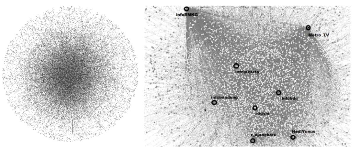
Figure 4: The visualized network generated by the 4.11 2012 tsunami warning tweet: general view (left), big nodes position in the core (right)
Figure 4 above visualizes the network generated by the first tweet of the 4.11 2012 tsunami warning. In the centre of the network, big nodes as listed in the Table 5 are located as central hubs of the network. In this network, each node represents a Twitter account (or user), and the links represent social ties among all the Twitter users. This network is a directed graph with the density of 0.001. Information flows throughout this graph will follow the direction of the links. This graph provides a general overview of the social network, and it is not intended for specific and detailed social network analysis. For further analysis, we used salient metrics which are shown in Table 5.
Table 5. Metrics of the BMKG Tweet tsunami warning network
Metric The 4.11 2012 Tsunami Warning Tweet Network
Number of nodes 6,246
Number of links 16,145
Graph density 0.001
Average degree 2.585
Network diameter 24
Weakly connected component 1,210
Strongly connected component 3,868
Average path length 7.001
Table 5 above shows salient metrics of the BMKG Twitter tsunami warning network. With 6,246 nodes and 16,145 links among them, the BMKG Tweet tsunami warning network has attracted 6,246 Twitter users who immediately followed the first Tweet tsunami early warning issued by the BMKG. In this particular Twitter tsunami warning network, the Twitter users show 16,145 social ties among them. If we consider the maximum possible links among the nodes, Table 5 shows that not all the nodes in this social network are connected with other nodes. This observation is consistent with the low graph density of 0.001. The graph density represents the ratio of actual social ties over maximum possible social ties in a network. The value of 0.001 indicates that direct interconnections among the Twitter users are rare. The average degree represents the average degree of attractiveness of a node in the social network. The value of 2.585 is slightly lower than the expected average of social networks, which is around 3. The diameter of the network represents the maximum distance between any two nodes. The number of 24 indicates that information needs to pass 24 other nodes before reaching its destination. It means that information travels such a distance. In contrast, the average path length of 7.001 is quite normal. It is the mean of the shortest paths among all the connected nodes. There are 1,210 weakly connected components and 3,868 strongly connected components. In a directed network, the number of weakly connected components is the sum of the nodes whose information flows are one-way, whereas the number of strongly connected components is the sum of the nodes whose information flows are bi-directional.
Figure 5: Locations of BMKG Twitter followers
Figure 5 above shows the ten locations of Twitter users, who followed the BMKG Tweet tsunami early warning, on the map of all the west coast of Sumatra, all the small islands off the west coast of Sumatra, and the south west coast of Java. The Figure 5’s picture was part of the 4.11 2012 first tsunami warning issued by the BMKG, which was shown earlier in Figure 1. Figure 5 shows the epicentre of the earthquake (marked with a red circle) and the predicted tsunami high-impact areas (marked with red and yellow line). While the red line on the map indicates the expected severe impacts of the tsunami, the yellow line shows the expected strong impacts. Using the BMKG map, in this research we then show the number of the BMKG Tweet tsunami early warning followers who are located in the tsunami high-risk areas. As shown on the map, we were able to identify the locations of 2,908 Twitter users (or 47%) out of all of our data set of 6,246 Twitter users. However, the remaining 3,338 (or 53%) failed to provide their location information. For those Twitter users who can be located on the map, we examined their locations to see if they are located in any of the predicted tsunami high-risk areas. Results show that 21 Twitter users (or 1%) were located in the west coast of Sumatra and Aceh, which was the most severely damaged area by the 2004 Indian Ocean tsunami. We also found 146 (or 5%) Twitter users in Northern Sumatra with its capital city of Medan and 78 (or 3%) in West Sumatra with its capital city of Padang. Padang was inundated by the 2009 tsunami and the 2010 earthquake. 18 (or 1%) of Twitter users were located in Bengkulu. However, a majority of the BMKG Tweet tsunami early warning network users were from Java, of those 46% were located in the Indonesia capital city of Jakarta and 14% are located in West Java. In addition to those Twitter users from western coast, twitter users were also located from the eastern coast of Sumatra: 49 Twitter users from Riau (Pekanbaru), 13 from Jambi and 4 from South Sumatra (Palembang). Finally, we located 91 (or 3%) overseas BMKG Tweet tsunami early warning followers.
CONCLUSION
In this research, we addressed the two research questions: Does Twitter work as a tsunami early warning network? If it does, how does the Twitter tsunami early warning network propagate tweets within a very limited time? These are very timely and important questions, because prior scientific research shows a very short lead time for the public to prepare themselves for mass evacuations, if the predicted tsunami eventuates in the after math of the catastrophic earthquake. We attempted to answer the research questions in the specific extreme disaster event context of the April 11, 2012 Indonesian earthquake. Fortunately, the predicted tsunami never eventuated. The Indonesian Government used the national Tsunami Early Warning System (InaTEWS) to collect and analyse data before it issued its official tsunami early warning. BMKG, a government agency responsible for geological disaster warnings, then used its Twitter channel to post its first Tweet tsunami early warning to the public. The BMKG Twitter followers began to retweet the BMKG Tweet to their own followers to create the Twitter tsunami early warning network during the extreme crisis event period. In answering the questions, we observed the (tweet) information flows of the 4.11 2012 first tsunami warning. In this research, we collected and analysed the data set of 6,383 tweets (or 82%) of all the tweets generated by the BMKG Twitter followers for the period of 16 days from June 18 to July 3, 2012.
The BMKG issued its first Tweet tsunami early warning in 6 minutes and 7 seconds after the 8.2 moment magnitude earthquake occurred off the west coast of Northern Sumatra. The BMKG Twitter followers from the predicted tsunami high-impact areas as well as from metropolitan cities retweeted the BMKG Tweet tsunami early warning to their own followers almost immediately. In consequence, within 15 minutes after the earthquake, the BMKG Twitter tsunami early warning network informed 4,102,730 Twitter users of the predicted tsunami. As we discussed earlier in this paper, there is a very limited lead time for the public to evacuate from the tsunami high-risk and high-impact areas after a large earthquake occurring off the coast. Governments with critical information
about the predicted catastrophic tsunami need to inform the public in a timely manner in order to mitigate the impacts of tsunami. Our research provided clear evidence for the utility of Twitter as a tsunami early warning network especially on the two of the three desired characteristics of early warning systems: reach and speed of communication we discussed earlier in the literature review section. However, we need future research on the information quality dimension.
This research also shows that the BMKG Twitter tsunami early warning network could effectively engage citizens and government disaster management agencies in diffusing the tsunami early warning information. Our social network analysis results clearly show the key relational mechanism by which the Twitter tsunami early warning was diffusing within the BMKG Twitter tsunami early warning network. The reach and the communication speed of the BMKG Twitter tsunami early warning network were realized by the BMKG Twitter followers who were alert enough to pay attention to the BMKG Tweet tsunami early warning, even though more than half of these followers were not located in the predicted tsunami high-risk and high-impact areas. Then they took an immediate action to retweet the BMKG Tweet tsunami early warning to their own Twitter followers. The top ten followers included mass media and well-known citizens in Indonesia. The salient social network analysis metrics suggest that while these BMKG Twitter followers were not tightly connected among themselves, some of them have relatively large followers and have social influence as Indonesia’s mass media, well-known Moslem preacher, and regional information channels. While Twitter is a viable complement to the extant information and communication transmission channels for disaster information communication, Twitter in this research functions not only as a transmission channel for tsunami early warning information but also as a social network, where some of the BMKG Twitter followers are actively diffusing tsunami early warning information within the social network. In as sense, these active BMKG Twitter follows are information agents and opinion leaders, especially when they have large followers of their own Twitter, in enabling the BMKG Twitter tsunami early warning network to reach as many as 4,102,730 Twitter users and inform them of the predicted tsunami in 15 minutes after the occurrence of the 8.2 earthquake.
The extreme disaster events of the past show the critical importance of tsunami early warning to mitigate the impact of devastating tsunami damage in the tsunami prone areas. In this regard, this research has provided evidence for the utility of Twitter as a tsunami early warning network with some important government policy implications. They include the social media policy for developing government-to-citizen relationships with the most influential followers of the government agency’s Twitter disaster warning network for timely information diffusion. However, we need to more rigorously classify the BMKG Twitter followers and their own followers based on their locations; namely, whether they are located in the predicted tsunami high-risk areas or whether they live in safe metropolitan cities. Our future research directions include a theoretical inquiry into the desired characteristics of social media tsunami early warning network on the three dimensions of reach, communication speed, and information quality and an empirical inquiry into locations of the Twitter tsunami warning followers.
REFERENCES
Baggio, R. 2008. "Network Analysis of a Tourism Destination." University of Queensland Australia.
Bales, M.E., Johnson, S.B., and Weng, C. 2008. "Social Network Analysis of Interdisciplinarity in Obesity Research," AMIA Annu Symp, p. 870.
Caragea, C., McNeese, N., Jaiswal, A., Traylor, G., Kim, H.W., Mitra, P., Wu, D., Tapia, A.H., Giles, L., and Jansen, B.J. 2011. "Classifying Text Messages for the Haiti Earthquake," Proceedings of the 8th International ISCRAM Conference, Lisbon, Portugal.
Chatfield, A.T., and Brajawidagda, U. 2013. "Twitter Early Tsunami Warning System: A Case Study of Indonesia’s Disaster Management Agencies," in: 46th
Hawaii International Conference on System Sciences. Hawaii, USA.
Cheong, F., and Cheong, C. 2011. "Social Media Data Mining: A Social Network Analysis of Tweets During the Australian 2010-2011 Floods," 15th Pacific Asia Conference on Information Systems (PACIS), P.B.S.a.S. Gregor (ed.), Brisbane, Australia: Queensland University of Technology, pp. 1-16.
Chung, K.S.K., and Chatfield, A.T. 2011. "An Empirical Analysis of Online Social Network Structure to Understand Citizen Engagement in Public Policy and Community Building," International Journal of Electronic Governance (4:1), pp 85-103.
Fortier, S.C., and Dokas, I.M. 2008. "Setting the Specification Framework of an Early Warning System Using Idef0 and Information Modeling," Proceedings of the 5th International ISCRAM Conference, Washington, D.C., USA, pp. 441-450.
Goggins, S.P., Mascaro, C., and Mascaro, S. 2012. "Relief Work after the 2010 Haiti Earthquake: Leadership in an Online Resource Coordination Network," in: CSCW’12. Seattle, Washington, USA.
Hui, C., Tyshchuk, Y., Wallace, W.A., Magdon-Ismail, M., and Goldberg, M. 2012. "Information Cascades in Social Media in Response to a Crisis: A Preliminary Model and a Case Study," Proceedings of the 21st international conference companion on World Wide Web, Lyon, France: ACM, pp. 653-656.
Ichiguchi, T. 2011. "Robust and Usable Media for Communication in a Disaster," Quarterly Review (4:October 2011), pp 44-55.
Jonnalagadda, S., Peeler, R., and Topham, P. 2012. "Discovering Opinion Leaders for Medical Topics Using News Articles," Journal of biomedical semantics (3:1), p 2.
Lu, Y., and Yang, D. 2011. "Information Exchange in Virtual Communities under Extreme Disaster Conditions," Decision Support Systems (50:2), Jan, pp 529-538.
Meissen, U., and Voisard, A. 2008. "Increasing the Effectiveness of Early Warning Via Context-Aware Alerting," Proceedings of the 5th International ISCRAM Conference, Washington, DC, USA, pp. 431-440.
National Research Council of the National Academies. 2007. "Successful Response Starts with a Map: Improving Geospatial Support for Disaster Management." Washington, D.C: The National Academies Press, 2007. Newman, A.V., Hayes, G., Wei, Y., and Convers, J. 2011. "The 25 October 2010 Mentawai Tsunami Earthquake,
from Real-Time Discriminants, Finite-Fault Rupture, and Tsunami Excitation," Geophysical Research Letters (38:5), p L05302.
Nugroho, Y. 2011. "Citizens in@Ction," HIVOS and Manchester Business School, Manchester.
Palen, L. 2008. "Online Social Media in Crisis Events," Educause Quarterly. July-September (20:0), p 8.
Qu, Y., Huang, C., Zhang, P., and Zhang, J. 2011. "Harnessing Social Media in Response to Major Disasters," in: CSCW 2011 Workshop: Designing Social and Collaborative Systems for China. Hangzhou, China. Schöne, T., Illigner, J., Manurung, P., Subarya, C., Khafid, Zech, C., and Galas, R. 2011. "Gps-Controlled Tide
Gauges in Indonesia – a German Contribution to Indonesia's Tsunami Early Warning System," Nat. Hazards Earth Syst. Sci. (11:3), pp 731-740.
Starbird, K., and Palen, L. 2010. "Pass It On?: Retweeting in Mass Emergency," in: Proceedings of the 7th International ISCRAM Conference. Seattle: International Community on Information Systems for Crisis Response and Management.
Teh, S.Y., and Koh, H.L. 2011. "Tsunami Simulation for Capacity Development," in: International MultiConference and Engineers and Computer Scientists (IMECS). Hong Kong: pp. 1528-1533.
Wamba, S.F., and Chatfield, A.T. 2009. "A Contingency Model for Creating Value from Rfid Supply Chain Network Projects in Logistics and Manufacturing Environments," European Journal of Information Systems (18:6), pp 615-636.
Wei, Z., Qingpu, Z., We, S., and Lei, W. 2012. "Role of Social Media in Knowledge Management During Natural Disaster Management," Advances in information Sciences and Service Sciences (AISS) (4 ).
Wood, M. 2005. "Cellalert, for Government-to-Citizen Mass Communications in Emergencies," in: Proceedings of the 2nd International ISCRAM Conference. Brussels, Belgium.
Ying, T. 2010. "Social Networks in the Tourism Industry, an Investigation of Charleston, South Carolina," in: Clemson University. South Carolina, USA: Clemson University.
Zimmermann, H. 2005. "Recent Developments in Emergency Telecommunications," in: Proceedings of the 2nd International ISCRAM Conference. Brussels, Belgium.
COPYRIGHT
Chatfield & Brajawidagda © 2012. The authors assign to ACIS and educational and profit institutions a non-exclusive licence to use this document for personal use and in courses of instruction provided that the article is used in full and this copyright statement is reproduced. The authors also grant a non-exclusive licence to ACIS to publish this document in full in the Conference Papers and Proceedings. Those documents may be published on the World Wide Web, CD-ROM, in printed form, and on mirror sites on the World Wide Web. Any other usage is prohibited without the express permission of the authors.