The EQIP GIS, Web-based Decision Program
Richard Farnsworth
Purdue University 765-496-3245 [email protected]Bernard Engel
Purdue University 765-494-1198 [email protected]Susan McCloud
Natural Resources Conservation Service 317-290-3200 [email protected]
Jin-Yong Choi
Purdue University 765-494-1196 [email protected]Kyoung Jae Lim
Purdue University 765-494-9772 [email protected]
Lawrence Theller
Purdue University 765-494-5954 [email protected]Selected Paper prepared for presentation at the American Agricultural Economics Association Annual Meeting, Denver, Colorado, August 1-4, 2004
Copyright 2004 by Farnsworth, Engel, McCloud, Choi, Lim, and Theller. All rights reserved. Readers may make verbatim copies of this document for non-commercial purposes by any means, provided that this copyright notice appears on all such copies.
The EQIP GIS, Web-based Decision Program
Authors*
Richard L. Farnsworth Bernard Engel Susan McCloud Jin-yong Choi Kyoung Jae Lim Lawrence ThellerKey words
EQIP, decision tool, GIS, conservation programs, information technology
Abstract
Working together, NRCS and Purdue University staff developed a GIS, web-based EQIP decision program. Landowners and NRCS personnel enter required EQIP information via a mapping service. Other subroutines store the information for use by NRCS in ranking and funding EQIP applications that receive the highest scores subject to budget
constraints.
*Richard L. Farnsworth, associate professor, Forestry and Natural Resources, Purdue University.
Bernard Engel, professor, Agricultural and Biological Engineering, Purdue University.
Susan McCloud, soil conservationist, Natural Resources Conservation Service, Indiana.
Jin-yong Choi, research associate, Agricultural and Biological Engineering, Purdue University.
Kyoung Jae Lim, research associate, Agricultural and Biological Engineering, Purdue University.
The EQIP GIS, Web-based Decision System
Reauthorized and greatly expanded under the Farm Security and Rural Investment Act of 2002, the Environmental Quality Incentives Program (EQIP) is a voluntary
conservation program for farmers and ranchers who want to mitigate their soil, water, and other resource problems while keeping their lands and livestock operations in production (U.S. NRCS, 2004a). Generally, farmers and ranchers submit tracts of land or livestock operations for possible enrollment in EQIP. Applications within a state are ranked according to each state’s established criteria. Successful applicants receive technical assistance, cost-share assistance, and incentive payments for implementing approved conservation practices. Cost-share assistance varies by conservation practice such as a waste storage facility or water and sediment control basin, but generally cannot exceed 75% of implementation costs. Incentive payments also vary by farming practice applied, the most frequently approved ones being no till, nutrient management and pest
management. State NRCS offices list the approved practices, cost-share rates, and incentive payments in their local offices and on the web. Indiana’s information may be viewed at http://www.in.nrcs.usda.gov/programs/2003eqip/PracticeList.html (Indiana
NRCS).
Program funding for EQIP increased more than five-fold from $200 million a year under the 1996 Farm Act to $6.1 billion for the years 2002 to 2007. Indiana’s EQIP allocation for 2004 equaled almost $11.6 million (U.S. NRCS, 2004b). This sizable expansion of EQIP motivated NRCS and other organizations to examine ways to improve administration of the program, assess environmental performance, and improve the
program’s environmental performance and cost effectiveness over time. NRCS in Indiana and Purdue University joined forces and created a GIS, web-based application and
selection decision system as a means of improving program implementation, improving consistency among counties, reducing staff workload time, providing a transparent record of the EQIP ranking process, and building a database for a spatial assessment of program impact. The blending of NRCS’s and Purdue’s areas of technical expertise resulted in a product with broad applicability throughout the United States. Furthermore, the EQIP decision system provides a framework for future work where program administration, implementation, assessment and modification are connected elements of one system. Our training version of the EQIP decision system is located at
http://pasture.ecn.purdue.edu/~eqip/DEMO/main_menu.cgi.
The EQIP Decision System
The purpose of a decision support system is to assist a decision maker in comparing and ranking competing alternatives based on their environmental, resource, and economic impacts (NRC, page 20). A comprehensive decision system consists of databases, simulation models, decision models, programming that links these
components, and user-friendly interfaces that keep the decision maker focused on making decisions. Though not mentioned explicitly, new information technologies, especially the Internet, are becoming an integral part of new decision systems.
Applying this description of a decision system to EQIP, the decision maker is NRCS. The short-term decision problem is the ranking and selection of EQIP
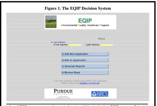
long-term decision problem includes program modification for improving environmental and resource performance at the same or lower costs. The EQIP decision system is a “thin client” system. The data, programming, models, scoring, ranking, and results reside on a central server. Clients, district NRCS staff working with EQIP applicants, access these components via a secure website using a number of user-friendly interfaces as shown in Figure 1. In a short amount of time, EQIP applicants learn about resource concerns on
Figure 1. The EQIP Decision System
Indiana NRCS uses a password protected version of this site for their EQIP program. Potential EQIP applicant must visit their district offices where they will work with the local staff to complete or edit an existing application.
their lands, decide whether to treat those concerns, receive a total score, and decide whether to submit an application for possible funding. At every step along the way, the applicant and NRCS professional can access support information such as descriptions of each resource concern, suitable conservation practices, and points allocated to each resource concern with and without treatment.
As shown in Figure 1, the EQIP decision system consists of four components. The first two components are used for entering new applications or editing existing
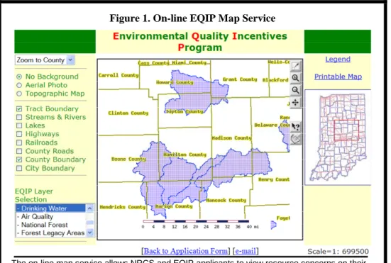
applications prior to the close of the signup period. The third component consists of county and state tables that summarize the applications submitted. After a signup closes, applications tentatively funded are also marked. A fourth component, “Browse Maps,” gives NRCS staff and applicants direct access to the system’s comprehensive GIS database via an Internet map service shown in Figure 2. The “EQIP Layer Selection”
Figure 1. On-line EQIP Map Service
The on-line map service allows NRCS and EQIP applicants to view resource concerns on their farms. Supporting data such as aerial photos, county roads, and streams allow them to quickly identify their operations.
contains the 19 resource concerns used in ranking and scoring applications. Each resource concern can be viewed separately by clicking on the named layer such as “Drinking Water, the layer shown in Figure 2. Additional spatial data layers such as aerial photos, streams and rivers, county roads, tract boundaries are useful in locating the land under consideration for EQIP. The availability of the underlying GIS data that forms
the foundation of the EQIP application process has proven to be very useful when applicants want to know how EQIP works in Indiana.
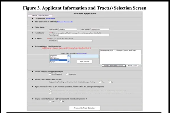
The process of submitting an application begins by clicking on the button “Add New Application.” The information screen shown in Figure 3 appears. Using this simple
Figure 3. Applicant Information and Tract(s) Selection Screen
In this example, the applicant is considering a tract in Tippecanoe county.
interface, the NRCS staff person enters the applicant’s name, county, and known tract numbers; whether it is a livestock or non-livestock application; and prior EQIP participation.
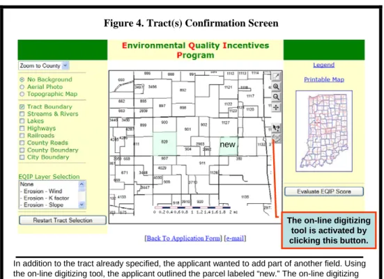
Once the information is entered, the next task is tract selection. In moving to the next screen, we begin to see the importance of the underlying GIS database and the usefulness of a map service as part of the decision system. If the tract or tracts provided by the applicant are part of the Farm Services Agency’s growing database of digitized
tracts, this information is transferred directly to the mapping service, which zooms directly to the specified tract(s). For our example, the tract exists as shown in Figure 4.
Figure 4. Tract(s) Confirmation Screen
In addition to the tract already specified, the applicant wanted to add part of another field. Using the on-line digitizing tool, the applicant outlined the parcel labeled “new.” The on-line digitizing tool can be used to identify tracts in counties where FSA has not completed its digitizing.
new
The on-line digitizing tool is activated by clicking this button.
If the Farm Services Agency has not digitized the county, the map service opens with the applicant’s county displayed. Given this situation, NRCS and the applicant use the map service to find the tract(s) being considered for EQIP. A digitizing tool has been added to the map service so that the tract or tracts are digitized and displayed. In the example, we added a new parcel to illustrate the addition of a tract using the digitizing tool.
The button “Evaluate EQIP Score” is clicked when the applicant is satisfied with the tracts that will become part of the EQIP application. A second subroutine starts and uses the polygons outlining the tracts to query the underlying GIS database for possible resource concerns. At the completion of the process, a summary table is created that lists
the resource concerns and identifies the resource concerns associated with the submitted tracts. The summary table and the results for our example are shown in Figure 5.
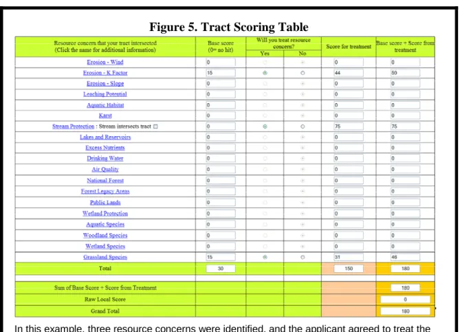
Figure 5. Tract Scoring Table
In this example, three resource concerns were identified, and the applicant agreed to treat the concerns. The 180 points plus a local score would be submitted as part of the EQIP offer.
At this juncture, an applicant may click on any of the nineteen resource concerns to learn more about them and possible treatments. Scoring is exhibited in “Base score” and “Will you treat resource concern?” columns. A decision to treat a resource concern increases the score. Prior to submitting the application, NRCS enters a raw local score that reflects each county’s unique scoring system for the resource concerns identified and treatments. Once the applicant is satisfied with his/her decisions, the NRCS person submits the information for storage in an Oracle database. Though not shown here, a summary report
is generated that summarizes the submitted EQIP application. As part of this summary report, NRCS has the opportunity to add a cost estimate of the application and add comments now or later. The report is printed with copies for NRCS and the applicant.
Any time before the end of the EQIP signup, the applicant may visit NRCS to revise the application, withdraw the application, or replace the application with a new application. Any changes are added to the existing record to minimize mistakes and misunderstandings.
The third component of the EQIP decision system generates reports at the county and state level from the Oracle database. Within the database and reports generated from the database, applications are ranked according to their score from highest to lowest. A portion of the 2004 signup with proprietary information removed is shown in Table 1.
Local and state NRCS staff can monitor scores and rankings as new applications are added to the database. Built-in tools allow the state NRCS office to specify the closing date of a signup and select a cutoff score for viewing all applications at or above the cutoff score for all applications, livestock only applications, and non-livestock
applications. Finally, the state office has access to a column to approve applications for funding. As the state office makes those decisions, they are viewable by county district conservationists as part of the reports component of the EQIP decision system.
First Year Results
The EQIP decision system became available for use in early January 2004. Statewide training consisted of a couple of half-day sessions using the training site we displayed in this paper. NRCS state staff handled most of the follow-up training and problem solving via the telephone. As expected, numerous small programming mistakes appeared and were corrected quickly to keep the system fully operational. Use increased substantially as March 15, 2004, the end of the signup period, approached and
contributed to a slowdown in response time. Overall, the system performed quite well with almost 1300 EQIP applications submitted throughout the state.
The EQIP decision system generated a number of expected and unexpected benefits. An earlier desktop version of the EQIP decision system called ESCORE was developed for the 2003 EQIP signup. Many of the obstacles associated with this system were avoided or minimized by using an on-line, thin-client version. The substitution of desktop GIS with a relatively easy-to-use on-line map service for example, significantly reduced the amount of GIS training for NRCS personnel. The
on-line service also removed the problem of distributing the needed data layers to county offices and maintaining them.
Second, the EQIP decision system resulted in the implementation of consistent enrollment criteria throughout the state. Misunderstandings about the procedures for identifying and treating resource concerns and applying the appropriate scoring rules were effectively eliminated by automating these tasks.
Third, EQIP decision system made the process more transparent and enhanced the ability of EQIP applicants to make informed decisions. The user-friendly, GIS interface allowed EQIP applicants to quickly find and query their fields for resource concerns, learn more about those concerns, decide whether to treat the concerns, and view how their decisions changed the resulting EQIP scores.
Fourth, a centralized electronic database improved program administration on several fronts. A centralized electronic database eliminated county collection and submission of paper files to the state throughout the signup period. It also allowed continuous monitoring of the signup as it progressed, including the number and distribution of contracts across the state. Once the signup ended, the state office had a ready-made database for allocating funds. With applications scored and ranked from highest to lowest, NRCS moved down the list until the allocated funds were
exhausted. Primarily one staff person completed a task that took several weeks and several staff last year in less than a week.
Fifth, the EQIP decision system significantly reduced every county’s workload two ways. Application management activities shifted to the state. Second, and
unexpected, the reporting system proved valuable in helping the county staff identify those applications that would likely receive funding. In doing so, the local staff could initiate field visits prior to the end of the signup period. The quick turnaround of tentatively funded EQIP applications shortly after the end of the signup has also eliminated unnecessary field visits.
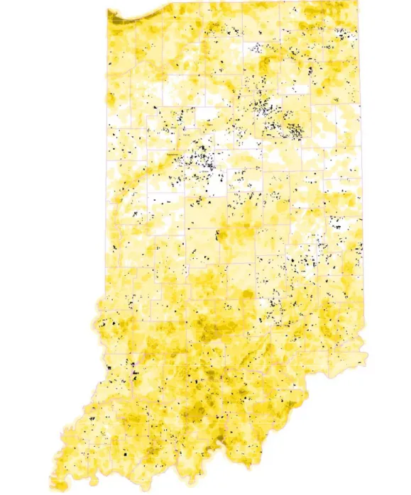
The sixth benefit of the decision system is the newly created geo-referenced database of EQIP applications and its pivotal role in program assessment at several different levels. A map of the 2004 EQIP applications and the maximum allowable scores of the 19 resource concerns is shown in Figure 7. Most notable is the large number of applications in the central part of the state and weighting of land in the sourthern part of the state. NRCS is already reevaluating its selection of resource concerns and scoring criteria. In addition, NRCS is investigating the reasons behind the large submission of EQIP applications from low priority areas. As long as the demand for EQIP funds exceeds available funding, many of these applications will not be funded. From an administrative viewpoint, efficiency can be improved by focusing staff on the high priority areas.
The geo-referenced EQIP application database can also be used to estimate program impact, especially with respect to soil, nutrients, and pesticides. Work by Khanna et al. has shown that the spatial distribution of conservation practices is critical. Given this information, researchers can use simulation models such as AGNPS and Gleams to estimate field level impacts and AGNPS to estimate impacts at the watershed scale.
Figure 7. EQIP Applications and Resource Concerns
EQIP applications are shown in black. Areas of highest
resource concerns are dark yellow; lightest, white.
Conclusions
Recent advancements in geographic information systems and available datasets, simulation models, and information technology made it possible to develop and implement the EQIP decision system. In its first year of use, the system assisted NRCS and applicants in understanding EQIP, especially the resource concerns and scoring rules; improved program consistency through the use of consistent
enrollment criteria throughout the state; streamlined program administration through the use of central storage of enrollment data, simultaneous updating and viewing of enrollment data within counties and across the state, and electronic distribution of the list of initially approved applications shortly after the signup ended; and set the foundation for program assessment and future improvements in EQIP.
Though it may seem premature given only one year of implementation, we feel confident in making several predictions regarding continued expansion of the EQIP decision system and it modification and use in other areas. Currently, the EQIP application information is stored in a separate database and then manually transferred to NRCS’s main database. As the system matures, a bridge will be built between the two database systems that will allow much greater access to the larger database. We also see a merging of the NRCS and Farm Services databases that will further enhance the ability of applicants to make better decisions.
Second, the collection of spatial information and merging of agency databases facilitates impact assessment. In the future, we predict the inclusion of hydrologic and other simulation models in the EQIP decision system. Models such as the Nutrient
Enabled NAPRA WWW Decision Support System
(http://danpatch.ecn.purdue.edu/~napra/SingleField/mainFrame.html) are available
and can be used to estimate field impacts using already available EQIP information. Efforts are underway to build a map interface that allows a user to select or digitize a polygon and then pass the underlying field and farm information directly to this simulation model.
Third, the framework of the EQIP decision system has broad relevance to a number of other programs and problems. The Conservation Reserve Program, for example, is a good candidate for a web-based, GIS decision system given its
similarity to EQIP. Given the two decision systems use of spatial data, it is reasonable to predict that landowners will be able to compare the benefits of EQIP and CRP within a common decision framework in the future.
In summary, the EQIP decision system has opened a new avenue for
implementing, assessing, and modifying programs. We predict the development and use of comprehensive on-line decisions systems similar to EQIP will increase and become an integral part of state and federal programs in the near future.
References
Khanna, M., W. Yang, R. Farnsworth, and H. Onal, “Targeting of CREP to Improve Water Quality: Determining Land Rental Offers with Endogenous Sediment Deposition Coefficients,” American Journal of Agricultural Economics, 85 (3), 538-553, August 2003.
Indiana NRCS. “Environmental Quality Incentives Program: Indiana – 2003.”
http://www.in.nrcs.usda.gov/programs/2003eqip/PracticeList.html. Accessed May 17,
2004.
National Research Council. “New Strategies for America’s Watersheds.” National Academy of Sciences. Washington DC: National Academy Press. ISBN 0-309-06417-1. 1999.
U.S. Natural Resources Conservation Service. “Environmental Quality Incentives Program.” http://www.nrcs.usda.gov/programs/eqip/ . Accessed May 17, 2004(a).
U.S. Natural Resources Conservation Service. “FY-2004 EQIP Allocations to States.”
http://www.nrcs.usda.gov/programs/2004_Allocations/EQIP_2004_alloc.pdf. Accessed