7
RURAL
Contents
7.1 Introduction
7.2 Resource Management Issues 7.3 Objectives
7.4 Policies 7.5 Strategy
7.6 Implementation
7.7 Anticipated Environmental Results 7.8 Description of Zones and Policy Areas
7.8.1 General Rural Zone 7.8.2 East Coast Rural Zone
7.8.3 Landscape Protection Rural Zone 7.8.4 Dune Lakes Zone
7.8.5 Countryside Living Zones — General Objectives and Policies 7.8.6 Kawau Island Zone
7.8.7 Islands General Zone 7.9 Activity Rules
7.9.1 Activities in the Rural Zones
7.9.2 Activity Table 1 — General Rural Zone, Countryside Living Rural Zone, (excluding the Okura Policy Area), Countryside Living Town Zone
7.9.2A Activity Table 1A — Okura Policy Area within the Countryside Living Rural Zone 7.9.3 Activity Table 2 — Landscape Protection Rural Zone; Dune Lakes Zone; East
Coast Zone; Kawau Island Zone (Bush and Settlement Policy Areas) (KI); and Islands General Zone
7.9.4 Earthworks and Vegetation Removal and Wetland Modification Activities 7.9.5 Activities within the Airfield Noise Contours at Dairy Flat
7.10 Development Controls and Performance Standards 7.10.1 Maximum Building Height
7.10.2 Maximum Height in Relation to Boundary
7.10.3 Minimum Yards
7.10.4 Maximum Site Coverage 7.10.5 Access to State Highways 7.10.6 Minor Household Units
7.10.7 Forestry in the Landscape Protection Rural Zone and East Coast Rural Zone 7.10.8 Buildings in the West Coast Policy Area
7.10.9 Matakana Village Overlay Area 7.10.10 Rules in Other Chapters of the Plan
7.11 Controlled Activities : Matters for Control and Assessment Criteria
7.11.1 Clean Fill Sites Exceeding 200m3 and Not Exceeding 1,000m3 in the General
Rural Zone
7.11.2 Assessment Criteria — Okura Policy Area
7.12 Restricted Discretionary Activities : Matters for Discretion and Assessment Criteria
7.12.1 Activities in Activity Tables 1 and 2 that Do Not Comply with Development Controls and Performance Standards
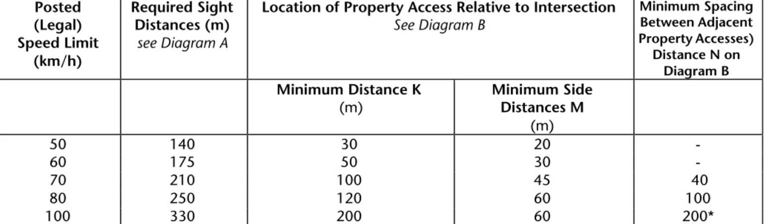
7.12.2 Access to State Highways
7.12.3 Buildings for any Permitted and Restricted Discretionary Activities in Specified Zones
7.12.4 Forestry in the Countryside Living Rural Zone 7.12.5 Household Units : One Single Household Unit
7.12.6 Household Units : A Second Household Unit in Addition to One Household Unit Per Site
7.12.7 Household Units on Maori Land 7.12.8 Multiple Household Units 7.12.9 Marae Use
7.12.10 Replacement of and Extensions to Existing Public Halls 7.12.11 Wineries which May Include Sales and Reception Areas
7.12.12 Earthworks, Tree and Bush Removal, Riparian Vegetation Removal and Wetland Modification
7.12.13 Activities within the Airfield Noise Contours at Dairy Flat 7.12.14 Minor Household Units
7.12.15 Assessment Criteria — Okura Policy Area
7.12.16 Greenhouses between 10% and 20% of net site area to a maximum of 1ha
7.12.17 Household Units and/or accessory buildings within Significant Natural Areas where there is no alternative location on the site
7.12.18 Activities within Quarry Effects Management Areas identified in the Planning Maps 7.12.19 Forestry in the Landscape Protection Rural and East Coast Rural Zones that
does not comply with Rule 7.10.7(a) or (b)
7.12.20 Visitor Accommodation within the Matakana Village Overlay Area
7.13 Assessment Criteria for Discretionary Activities
7.13.1 General Assessment Criteria – All Discretionary Activities 7.13.2 Additional Assessment Criteria in Specified Zones 7.13.3 Kawau Island Zone – Bush and Settlement Policy Areas
7.13.4 Additional Assessment Criteria for Particular Activities 7.13.5 Okura Policy Area – Assessment Criteria
7.14 Assessment Criteria for Discretionary Activities
7.14.1 Subdivision Status
7.14.3.1 Subdivision of Sites for the Protection of Significant Wetlands 7.14.4 Subdivision for Significant Enhancement Planting
7.14.5 Subdivision for Significant Land Rehabilitation 7.14.6 Subdivision for the Creation of Esplanade Reserves 7.14.7 Subdivision for Creating Additional Public Reserve Land 7.14.8 Subdivision for Household Unit Sites on Maori Land 7.14.9 Subdivision of Countryside Living Rural Sites
7.14.10 Subdivision of Countryside Living Rural Cluster Housing Sites 7.14.11 Subdivision Standards — Okura Policy Area
7.14.12 Subdivision of Countryside Living Town Sites
7.14.13 Subdivision of Low Intensity Settlement sites in the Kawau Island Zone — Settlement Policy Area Only
7.15 Subdivision : Restricted Discretionary Activities : Matters for Discretion and Assessment Criteria
7.15.1 Matters for Discretion
7.15.2 Assessment Criteria : All Subdivision
7.15.3 Assessment Criteria : All Subdivision Within the East Coast Rural Zone
7.15.4 Assessment Criteria : All Subdivision within the Landscape Protection Rural Zone 7.15.5 Assessment Criteria : Subdivision for the Protection of Natural Areas
7.15.6 Assessment Criteria : Subdivision for the Creation of Esplanade Reserves 7.15.7 Subdivision for the Creation of Additional Public Reserve Land
7.15.8 Subdivision for the Creation of Household Units sites on Maori Land 7.15.9 Subdivision of Countryside Living Rural Sites
7.15.10 Subdivision of Countryside Living Rural Cluster Housing Sites
7.15.11 Additional Assessment Criteria Applying to Subdivision within the Okura Policy Area 7.15.11A Assessment Criteria Applying to Subdivisions within the Okura Policy Area being
Assessed as a Discretionary Area
7.15.12 Subdivision of Countryside Living Town Sites 7.15.13 Low Intensity Subdivision — Kawau Island 7.16 Discretionary Activities : Assessment Criteria for Subdivision
Appendices
App 7A Access to State Highways : Diagrams A and B
App 7B Guidelines for the Field Assessment of Native Quality in Rodney District App 7C Guidelines for the Field Assessment of Wetland Quality in Rodney District App 7D Land Affected by Fletcher Woodpanels Covenant under Rule 7.4.2.15.7 App 7E Guidelines for Native Revegetation Plantings
App 7F Guidelines for Exotic Plantings
App 7G Statutory Acknowledgement and Statutory Areas — Te Uri O Hau Claims Settlement Act 2002 App 7H Site Identified for Rural Hamlet Conservation Subdivision (Rule 7.14.14)
7
7.1
RURAL
INTRODUCTION
Over 90% of the District’s 247,500 hectares can be described as rural, resulting in a character dominated by rural elements, despite the fact that over 60% of the District's population live in urban centres.
Physically the rural area is one of contrasts, brought about by the varied topography and climate and the range of human activities carried out within it. It is flanked in the west by the exposed, high energy Muriwai Beach and sand dunes, and by the broad shallow expanse of the Kaipara Harbour with its associated coastline and wildlife habitats. In the east, indented bays, sheltered gulf waters, harbours and sweeping ocean beaches backed by rolling hills characterise the coast. The central and northern areas comprise mainly rolling pastoral land and dissected hill country in a mixture of pasture, exotic forestry and indigenous bush. In the south the land is flat to rolling country with significant indigenous bush areas, and natural features such as the Te Henga wetland in the south western-most part of the District.
The climate and soils are of variable quality for production, with the most versatile soils being located in the south around Kumeu/Huapai/Waimauku, and in the north, in a much smaller area in the vicinity of Omaha. On these versatile soils numerous types of horticulture are carried out, including vineyards and related wineries.
Pastoral farming is carried out throughout the District, including dairy farming, beef, sheep and deer farming. Exotic forestry is also a major land use, particularly on the dune country backing Muriwai Beach, around Riverhead in the south and below Mangawhai in the north.
Many of the area’s agricultural and forestry activities have been driven by its proximity to the Auckland market, even though forestry was established for soil conservation purposes and in some areas as a means of utilising land that was considered marginal for agricultural purposes. The land has proved to be especially suitable for forestry and some horticultural and viticultural purposes.
Mineral resources in the form of aggregate, limestone, and sand are quarried within the rural area. Aggregate is currently quarried at a number of locations throughout the District, and is used for roading, building, construction and concrete production. There are numerous locations throughout the District at which limestone is quarried, for farm tracks, some sub-base applications and for the application of agricultural lime.
Sand is extracted from dunes on the east coast and from the seabed adjacent to the District, at Pakiri and in the Kaipara Harbour.
The rural area contains a number of sites of high natural environment value, including areas of native forest, wetlands, freshwater lakes, coastal foreshore and headlands. A number of these sites have regional and national significance and all contribute to the amenity value of the rural part of the District. These features, combined with topography and features such as the sea, lakes and rivers, and the non-urban context collectively create attractive
Auckland Council District Plan (Rodney Section) 2011 ………..….
>
Rural : Chapter 7 1landscapes, and high amenity values within the rural area. There are also combinations of features which have created areas of special character that distinguish Rodney from other Districts within the Auckland Region.
Traditionally the rural parts of the District have been where agricultural and primary production activities have taken place, but increasingly the lifestyle opportunities in the District have become an increasingly major component of its character. Lifestyle development has occurred in the areas close to the metropolitan Auckland and increasingly, along the coastal fringe on both coasts, where access is off the main road transport links - State Highway 1 or State Highway 16. In areas close to metropolitan Auckland, lifestyle development already dominates the character of the rural land and the expectations of many who live there. The transition of some parts of the District from production based activities to a mix of lifestyle and production activities, is likely to continue.
Key pressure
One of the key management pressures for the District relates to its proximity to metropolitan Auckland. The southern and south western rural parts of Rodney District abut North Shore City and Waitakere City. The urban growth pressures from these urban-based Councils spills into rural Rodney.The Auckland Region continues to experience significant growth and the next fifty years may see a doubling of the population to 2 million. Although the Regional Growth Strategy envisages that the Metropolitan Urban Limits will be retained within both North Shore City and Waitakere City, continued demand for rural lifestyle opportunities within Rodney District is expected throughout the fifty year horizon of the Auckland Regional Growth Strategy.
Extensions to both the Northern Motorway, as far north as Puhoi, and the North Western Motorway, to Kumeu and beyond, will continue to bring the rural parts of the District closer to Auckland with respect to travel times. Significant parts of the District around the metropolitan fringe of
Auckland have been experiencing lifestyle development to the extent that lifestyle activities are now the dominant land use for a large portion of the District. The metropolitan fringe area faces considerable pressure from urban sprawl and conflicts between lifestyle and rural activities as well as urban related activities seeking to establish in the fringe areas.
As well as in the metropolitan fringe area the District continues to face growth pressures in coastal areas, particularly on the east coast north of Orewa. Once again the demand for lifestyle activities places significant pressure on the coastal landscapes, the beaches and harbours of the District. These coastal environments are of regional significance and require specific consideration with respect to the possible adverse effects of further subdivision and development.
The rural area has a dynamic nature. Rural activity has rarely stood still for long. It is marked by constant change of varying degrees, brought about by the interaction of human activity with the rural land resource, and the natural features and landscapes forming part of that resource.
Auckland Council District Plan (Rodney Section) 2011 ………..….
>
Rural : Chapter 7 27.2
RESOURCE MANAGEMENT ISSUES
In the rural part of the District the significant resource management issues are as follows:
Issue
7.2.1
Rural character can be adversely affected by subdivision and land
use activities.
Rural character Many factors come together to create rural character and distinguish
rural areas from urban areas. This is particularly so in Rodney because of the size of the District, the physical variety in the natural environment and the diversity of activities undertaken within that environment.
In general, the elements making up "rural character" include:
(a) The predominance of natural features over man made features
(b) A very high ratio of space not built upon (open space) to built upon space on individual sites.
(c) The presence of large areas of vegetation, in the form of grass, trees, crops and indigenous vegetation.
(d) The presence of large numbers of farmed animals and extensive areas of plant or fruit crops and plantation forests.
(e) Noises, smells and visual effects associated with the use of the land for a wide range of farming, horticultural, mineral extraction and forestry purposes.
(f) A low density of building and structures because site sizes are in hectares rather than square metres.
(g) Low population densities.
(h) Generally narrow roads with swales/open drains, including a number of unsealed and low speed geometry roads; and generally low traffic volumes (except State Highways and arterial roads).
(i) A general absence of urban scale and urban type infrastructure, such as roads with full kerb and channel, sealed footpaths and vehicle crossings, streetlights, electricity transformers, bus shelters, telephone cabinets and demarcated carparking areas on roads.
(j) The use of land for mineral extraction activities.
Agriculture and farming
Agriculture and farming are important components of rural character.
Although perhaps not as significant as they have been in the past the physical use of large parts of the District is still associated these activities. Changes have taken place in parts of the District that have eroded the dominance of agriculture and farming to create a different rural character particularly in those areas closest to metropolitan Auckland
.
The economics of rural production continue to change, however Auckland Council District Plan (Rodney Section) 2011 ………..….
>
Rural : Chapter 7 3time production rather than full time production tends to dominate farming activity. Nevertheless agriculture and farming, in one form or another, is a key component in the character of most rural parts of the district. The range of farming activities extends from the traditional pastoral activities, forestry, vineyards, orchards and commercial vegetable growing, through to intensive farming activities, such as covered horticultural crops, poultry farming and the like.
The rural character of these more traditional farming portions of the District are that sites are generally larger than 20 hectares (in many cases significantly larger), and they are dominated by pastoral farming with extensive areas of open space, with houses and farm buildings scattered along roads or generally within a short distance from the road. There are few or no commercial centres or settlements with large distances between centres where they do exist. Schools tend to be the focus of these communities rather than shops or towns, although there is usually a town or settlement which serves a wide surrounding area. Commuting to Auckland for work becomes a less significant factor the greater the distance from Auckland itself. Thus, the northern parts of the District have a character based on traditional farming activities.
Key pressure A key pressure on rural character is the growth pressure exerted from metropolitan Auckland. The Auckland Region has the potential to experience a doubling in population by 2050 to two million people. The rate of growth and how this is accommodated and managed has the potential to adversely affect Rodney’s rural character. In particular, significant areas around Auckland’s metropolitan fringe face considerable pressure from urban sprawl and conflicts between rural, lifestyle and urban activities.
A second key pressure is on the coastal areas of the District where demand for lifestyle activities is also high.
Urban-rural fringe around Auckland
The urban-rural fringe around metropolitan Auckland has over a period of years become fragmented into smaller titles with lifestyle residential development becoming widespread. In some areas the lifestyle development has become dominant. However, in most instances, remnants of the farming activities remain and there is a mix of farming and lifestyle activities. The character of these areas is significantly different from the more traditional farming areas.
Properties in this area are generally less than 10 hectares with many 4 hectares or less. Houses and buildings tend to be larger, more modern and have more significant capital investment and are closer together. People tend to work within Auckland and commute each day by car. Any use of the land tends to be less intensive and less productive, although there are many examples of both intensive and productive usage from small land holdings. Larger pastoral farms have become the exception rather than the rule. Full- time farmers are almost non-existent. The intensity of residential development, although sparse compared to urban areas, has increased. Although open space is a key element, it has become fragmented through fencing, planting, landscaping and the siting of buildings. There are far greater volumes of traffic generally in these areas, particularly on the main roads.
Auckland Council District Plan (Rodney Section) 2011 ………..….
>
Rural : Chapter 7 4The process of subdivision creates separate legal entities (sites) with each new separate entity having a bundle of rights under the Plan and a set of landowner expectations about what can be done with each new separate entity, eg. erection of a household unit. Subdivision is therefore the first step in a process which can ultimately result in changes to and adverse effects on rural character.
Although individual subdivisions and resulting activities may only have limited adverse effects on their own, the cumulative effect of several or many subdivisions and subsequent activities may be significant. For example, in a landscape with a number of 50 hectare farms, subdivision and development of many of these into 4 hectare sites results in a different character than that of the 50 hectare farms. It may still be rural, but it is different. Subdivision therefore both individually and cumulatively can adversely affect rural character.
Coastal and harbour areas The District is very large, with extensive coastal and harbour areas. There
exist a number of landscapes and natural features of both regional and local significance which have been identified and protected for a number of years. The character of these areas is quite different from the lifestyle character of the urban rural fringe and the agricultural character of the farming areas beyond the fringe.
The character of these areas include coastal landscapes and landforms, remoteness, high value natural landscapes which are relatively unmodified, lake, river, harbour and estuary environments, island environments, special habitat environments and areas which contain significant areas of native bush.
Adverse effects Areas with rural character, incorporating the elements outlined above, can be
adversely affected by ongoing development (including subdivision). The adverse effects can be direct, on a defined area, and they can be cumulative, where the net result of a number of individual activities is to erode or cause the total loss of rural character.
Given the nature of rural character, it is the cumulative effects of the individual subdivisions and developments that are the basis of the issue. For example, in a traditional farming area (eg. inland Northern Rodney) comprised of 50 hectare farms, the natural features would almost certainly predominate over human made elements. However, subdivision of this area into a series of 1 or 2 hectare sites and the additional houses and accessory buildings, the additional traffic generated including pedestrians, the presence of vehicle crossings and driveways, letter boxes and other structures, would all change this perception significantly. It would contribute to the cumulative effect of individual subdivision and development on rural character. The cumulative effect is also significant in terms of the effects of additional trips generated by the household units on the transport network, particularly the State Highway network.
One other element of the issue is the erosion or loss of the distinctive character of various parts of the District which provide it with a unique identity and which exhibit more fully than other areas, the general elements making up rural character. The loss or erosion of rural character is likely to be more readily perceived in these areas, and can adversely affect the perception
Auckland Council District Plan (Rodney Section) 2011 ………..….
>
Rural : Chapter 7 5that Rodney is, for the most part, still a rural district. In addition, the distinctive parts of the District, with their special character, provide a large part of Rodney’s identity. They are typified by a high degree of "naturalness" and high amenity values, based on the existence of particular physical features such as beaches, coastline or distinctive landforms. Part of the District’s identity can be lost when this special character is degraded or lost entirely. The coastline and related inland area on the eastern coast, and the dune lakes and sandhills on the South Head Peninsula, are examples of areas with special character contributing significantly to the Rodney identity.
Even the area closest to urban Auckland with its existing predominance of smaller sites can be adversely affected by levels of subdivision and activities representative of urban rather than rural areas. Providing for the dynamic nature of the rural area and at the same time avoiding adverse effects on the essential elements of rural character, is the crux of the issue.
Issue
7.2.2
Rural amenity values can be adversely affected by subdivision and
land use activities.
Amenity values Amenity values are the qualities and characteristics of an area on which
people base their appreciation of its pleasantness or attractiveness. People make an assessment of amenity values by identifying the matters they find make their local environment a pleasant place to live and/or work. Such an assessment usually contributes to a decision to purchase land in a particular place.
Identified amenity values
The Council as part of the preparation of the District Development Strategy
which was adopted in 1994 undertook surveys which identified the values that residents considered as "good things about living in Rodney". In one survey 819 adults or 5.7% of the population of south Rodney were questioned. A similar survey was undertaken in Northern Rodney. The findings of those surveys were reinforced through the results of more recent consultation such as that carried out during the preparation of Vision Rodney, the District Strategy document, and are considered to remain valid in terms of the community value placed on these matters.
The values identified were: the country lifestyle; the countryside; close to beaches; close to Auckland; friendly people; tranquil and peaceful; away from the City; community life; outdoor lifestyle; privacy and rural views. Individual environmental values which were considered to be important were also identified and these are important in determining amenity values within rural areas. The environmental aspects of value identified were: rivers and streams; coastal waters; air quality; coastline; native bush; bird life; peace and quiet; soil quality; trees; wide open spaces and cultural sites.
Variations in amenity values With respect to rural amenity values these vary considerably across the
District and they can change significantly within a short distance. A rural property with an outlook to a nearby major highway is likely, because of road traffic noise, to have entirely different amenity values to a neighbouring property which has no such outlook or exposure to road traffic noise. A property with an extensive rural or coastal outlook contrasts with a neighbouring one which may have no views at all. A lifestyle property surrounded by other lifestyle properties has different amenity value than one surrounded by large farms or one surrounded by an area of protected native Auckland Council District Plan (Rodney Section) 2011 ………..….
>
Rural : Chapter 7 6bush.
Adverse effects on amenity values Amenity values can be adversely affected by activities which infringe upon
them (eg. quarrying, landfill, earthworks, aerial spraying, subdivision and housing developments, etc). Such adverse effects include noise, traffic on roads, particularly heavy trucks, visual impact, lighting, odours, dust, vibration, inadequate disposal of effluent/water, and loss of privacy etc. Loss of native bush and negative effects on rural landscapes are also adverse effects on amenity values. Most activities in rural areas contain some element which can adversely affect amenity values in some way unless mitigation measures are adopted. Intensification of development in particular, can adversely affect rural amenity values, where mitigation measures do not accompany such development. As subdivision is most often the precursor to more intensive development, it is the first stage in a process that can result in adverse effects on many of the amenity values people live in rural areas to enjoy. The cumulative effects of a number of subdivisions can potentially adversely affect amenity values. Some activities can result in significant adverse effects on amenity values which cannot be adequately mitigated (eg. intensive horticulture, pig and poultry farming) in some situations.
The nature of the "receiving environment" throughout the rural area has some bearing on the degree to which an effect is considered to be adverse. Similar activities can be perceived as having lesser or greater adverse effects on amenity values depending on the nature of the environment in which they occur. For example, a quarry in a remote area of the District is less likely to impact on amenity values than an operation close to a lifestyle subdivision area where residential development is more intensive.
Perceptions of amenity values Another element of this issue is the conflict arising from differing perceptions
of which effects on amenity values are acceptable in rural areas. One of the major areas of conflict experienced in the District has been generated by those seeking to live in the rural area for "lifestyle" reasons perceiving effects generated by those using the rural resource base for productive purposes as adverse. The expectations, in terms of amenity values, held by these two groups can differ markedly. Experience to date has been that the "lifestylers" often expect fewer adverse effects on amenity values such as quietness and privacy, than some traditional rural production practices generate. Thus rural production activities which incorporate late night or early morning vehicle or stock movement, crop spraying, bird scaring, hay-making amongst other things can adversely affect what lifestyle residents regard as appropriate amenity values in the rural part of the District. At the same time these effects are considered a legitimate part of the rural environment by the rural producers.
This difference in expectations can mean that other "traditional" rural based activities, such as quarrying, landfilling, firearm ranges, dog kennels and catteries, which are often socially and physically acceptable in sparsely settled rural areas, become more difficult to establish as housing densities increase. Mineral extraction is one such activity potentially affected by this result of intensification because it can only be located where minerals occur. Some resources may become unrecoverable where they are located near more sensitive land uses, such as countryside living, because such activities demand a higher standard of amenity values than mineral extraction can readily provide.
Auckland Council District Plan (Rodney Section) 2011 ………..….
>
Rural : Chapter 7 7The other element to this issue is adverse effects on amenity values of different rural production type activities. Examples are odour from pig farms or fertilising land causing nuisance, and the use of chemical sprays affecting enjoyment of neighbouring farms/properties. Dust and noise from mineral extraction activities affecting the amenity values of neighbouring farms is another example, as is a high traffic generating activity, which may affect road safety and efficiency for other road users in the vicinity.
Issue
7.2.3
Rural productivity can be adversely affected by activities.
Different rural based activities generate a range of adverse effects, some of which can affect the ability to undertake productive activities or the productivity of rural activities on neighbouring sites. For example, mineral extraction or landfill operations can generate dust which can affect the state of surrounding pasture or the quality of horticultural crops on neighbouring sites. Similarly activities involving spraying of fertilisers or insecticides/pesticides can adversely affect organic farming operations or other chemical sensitive activities on neighbouring properties, while organic production activities may conversely impact upon neighbouring non-organic production activities. Such effects can reduce productivity on the sites affected and have some adverse effect on the economic viability of particular operations.
Issue
7.2.4
Subdivision, land use and development can have adverse effects,
including cumulative effects, on native plant and animal
biodiversity.
Biodiversity is the variability amongst organisms, including the diversity within species (genetic diversity), between species (species diversity) and the diversity of ecosystems (ecological diversity).
Rodney District reflects the national trend of loss and modification of natural ecosystems and the resultant loss of biodiversity. While certain areas, especially in the northern part of the District, still retain large areas of bush or relatively unmodified landscapes, most of the ecosystems within the District are fragmented, isolated pockets of bush, wetlands, dunes and dune lakes, estuaries and scrubland. Less than 15% of the original bush remains, with the majority having been cleared between 1860 and 1984 to create pasture. Less than 1% of the wetlands remain, most having been drained between 1942 and 1977 for agriculture and urban development.
The ongoing threats to natural ecosystems include:
(a) Subdivision in or within close proximity to significant areas of native plants or native animal habitats.
(b) Stock grazing the understorey of bush or margins of wetlands or rivers and streams, due to inadequate fencing.
(c) Clearance of areas of native plants or native animal habitats for forestry, agriculture and residential sites.
Auckland Council District Plan (Rodney Section) 2011 ………..….
>
Rural : Chapter 7 8(d) Recreation activities, such as biking, tramping and horse riding within or in close proximity to natural ecosystems.
The results include ongoing fragmentation, damage and destruction of ecosystems and habitats. The impacts of this include:
(e) A reduction in the environmental carrying capacity and ability to sustain animal and plant species.
(f) Increased edge effects (ie. increased sunlight and decreased humidity at the edge of the bush) resulting in less species diversity because the lower temperatures of the inner areas (ie. microclimates) are never reached and therefore species which need these cooler temperatures cannot grow and also species which are not tolerant to disturbance disappear and more tolerant species take over (eg. weeds).
(g) Reduction in seed dispersal, especially where neighbouring bush remnants are too far apart.
(h) Barriers to movement of animals if remnants are too far apart.
Research indicates that in order for areas of bush to be viable and to have the species diversity, the bush area should, ideally firstly, be a minimum of 10 hectares and, secondly, have another area of bush of a similar size within 1 kilometre. Areas of bush less than 10 hectares are, however, important (especially in the absence of larger areas). The value of these areas increases with their proximity to other such areas and where they form part of a network or corridor, and other factors such as species diversity, presence of weeds and pests and management regime also have a strong bearing on the value. In many instances animal and plant species will not move between native ecosystems unless there is a suitable vegetation connection between two areas (ie. an ecological corridor). If these corridors are destroyed the whole ecosystem becomes less viable.
Less is known about the viable size of other ecosystems.
Rural subdivision and development may adversely affect ecological values including intrinsic values of Okura estuary and the existing areas of native terrestrial vegetation and habitats. There is, however, opportunity through further subdivision and development to protect areas of native vegetation and wetland areas and for the maintenance and enhancement of ecological corridors.
Issue
7.2.5
Subdivision, land use and development can have adverse effects
on riparian margins.
Traditionally, a large number of riparian margins have been cleared for agricultural purposes or during subdivision and land development. This has resulted in the following:
(a) stock trampling the banks and causing stream bank erosion; (b) less habitat for nesting and terrestrial species;
Auckland Council District Plan (Rodney Section) 2011 ………..….
>
Rural : Chapter 7 9(c) loss of ecological corridors which link larger bush or scrub areas;
(d) potential increase in flooding area and peaks as vegetation is important in absorbing and retaining water in the catchment and slowly releasing the water downstream throughout the summer;
(e) changes in water quality and habitat as stream temperatures have increased through lack of shading and there is little or no vegetation to filter out nutrients and other contaminants or reduce erosion.
There is increasing realisation of the value in protecting riparian margins and some landowners are fencing off these areas, keeping stock out and replanting. Developers are also protecting these areas to mitigate the adverse effects of subdivision. Many community action groups, such as landcare groups see the replanting of riparian margins as key areas for restoration to mitigate some of the adverse effects, especially erosion and loss of habitat.
In the Auckland Region approximately 30,000 native trees are planted annually. An estimated 10% of these are for riparian enhancement or restoration.
Issue
7.2.6
The versatility of rural land can be lost through inappropriate
subdivision and land use.
The rural parts of the District have experienced a high level of subdivision over recent years and this is still continuing. The net result has been a substantial increase in the number of smaller rural sites and a decline in the number of larger sites. A comparison of the valuation roll holdings over time shows that a major increase in the number of sites has occurred in the 1 to 8 and 8 to 20 hectare range.
The continuing subdivision of land into smaller lots reduces the potential of the land to be used for a range of more traditional types of farming activities such as beef and dairy farming. Subdivision is generally irreversible because in most instances amalgamation of sites for a particular rural production based purpose becomes too expensive. This results from the fact that once a site is created it is assigned rights for use under the District Plan, with these rights normally including the ability to establish a dwelling and the site is valued accordingly. Where houses are established, entranceways and infrastructure provided etc, the value of the site means that amalgamation is difficult except for the instances where the output from the land will be of extremely high value.
Fragmentation, therefore, reduces the ability of the land to be used for activities requiring larger land areas should market or cultural conditions dictate such an approach. Retention of land of differing soil types in a range of site sizes is necessary to maintain the versatility of rural land in order to respond to changing needs and aspirations of the present and future populations.
Loss of versatility can also occur through the physical location of activities that render the land unusable for primary production to all intents and
Auckland Council District Plan (Rodney Section) 2011 ………..….
>
Rural : Chapter 7 10purposes. This is of particular concern in relation to land which is highly suitable for food production, given the relatively small proportion of soils that have this characteristic within Rodney ie. the limited areas of Class II soils (as defined on the New Zealand Land Resource Inventory Worksheets) within the District. Locating areas for urban purposes or the most intensive forms of Countryside Living on the most fertile soils, for example, could result in the long term loss of the land from productive use.
Issue
7.2.7
Degradation of soil resources can result from inappropriate land
use.
Due to the time scales involved, for all practical purposes, soils are a non- renewable resource. Soil forming processes occur over thousands of years to produce a suitable medium for plant growth. It is essential therefore, to protect soil from both natural and induced forms of degradation and to ensure that the life supporting capacity of soils is maintained. In effect this means utilising the resource in a variety of ways while maintaining its inherent physical, chemical and biological properties.
The use and development of rural land for productive and other purposes, such as rural residential lifestyle, has the potential to cause soil erosion at a much faster rate than would occur naturally. The clearance of vegetation, inappropriate farm management practices, such as overstocking, or cultivation on steep slopes, and activities such as forming access roads, farm races, and areas for household activities could all expose soil and accelerate natural erosion processes.
These erosion processes can be dramatically slowed by retiring land areas that are steep and erosion prone and replanting these areas to restore a protective vegetative cover.
Soil structure Loss of soil structure can occur and have adverse effects on soil drainage and
fertility. Degradation of soil structure is accelerated by activities such as excessive cultivation, vehicle compaction or stock trampling.
Soil fertility Soil can lose its fertility through cultivation processes resulting in leaching of minerals, and through plant uptake of nutrients exceeding nutrient (fertiliser) application or incorporation of nutrients by natural processes
.
Chemical application Soil degradation can also result from the wrong or inappropriate application
of chemicals, such as herbicides and pesticides, and leakage of chemicals or toxic wastes from industrial processes or storage facilities.
Contaminated sites There are over 100 known potentially contaminated sites in the District
resulting from industrial processes or storage activities. The number of actually contaminated sites is unknown, but there must be many on rural land where herbicides and pesticides have been stored or applied.
Such contamination has the capacity to alter the chemical and biological balance of soils and the potential to adversely affect the health of humans and animals and vegetation. NZS 8409:2004 Management of Agrichemicals was prepared with the aim of ensuring that where agrichemicals are handled or used, the practices followed are safe, responsible and effective, with Auckland Council District Plan (Rodney Section) 2011 ………..….
>
Rural : Chapter 7 11minimal adverse impact on human, environmental and animal health.
Dairy shed discharge also affect soils adversely by increasing the nitrate levels and pH, potentially contaminating soils and waterways.
The aforementioned types of land degradation also result in off-site effects in the form of the discharge of sediment, chemical contaminants and excess nutrients to receiving water.
Issue
7.2.8
Water quality can be adversely affected by subdivision and land
use.
Rural subdivision and land use activities can adversely affect water quality in a number of ways. Overland runoff in rural areas contributes significantly to water pollution, particularly because such runoff includes faeces and urine from grazing stock, herbicide and pesticide residues and fertilisers. Such pollution is exacerbated by the loss of riparian vegetation and damage to riparian margins and waterways by stock access. . Pastoral agricultural activities represent the main source of threat to water quality as such activities have resulted in pollution of surface and ground waters with sediment, animal waste and nutrients.Land modification and earthworks
Land modification and earthworks can generate significant water pollution in
the form of sediment. Common activities with this potential are the creation of building sites and accessways, and the removal of vegetation along waterways or on steep slopes. Subdivision of land generally necessitates the creation of additional accessways and building sites. Both these processes can involve disturbance of soil with potential for siltation of waterways or waterbodies.
Septic tanks Septic tank systems associated with dwellings can also adversely affect water
quality if the wastewater is not treated to an appropriate level, the systems are not operated and maintained correctly or disposal lines are inappropriately located. Appropriate standards need to be followed to ensure that there are no adverse affects on water quality.
Okura Catchment Rural subdivision and development within the Okura catchment has the
potential to adversely affect water quality of the Okura estuary and marine reserve.
Issue
7.2.9
Subdivision and land use can inhibit the operation of existing
mineral extraction sites and the potential future utilisation of the
mineral resource on the site.
Mineral deposits tend to be in fixed locations, unevenly distributed and generally non-renewable. In many instances mineral resources are scarce. Consumption of aggregates and other minerals is directly related to population growth. Even when growth is low, aggregates are required for the maintenance of infrastructure and buildings.
Subdivision or development, especially in areas adjacent to existing quarries can restrict quarrying activities. In some instances, this can result in the Auckland Council District Plan (Rodney Section) 2011 ………..….
>
Rural : Chapter 7 12closure of a quarry, especially as community values change and people become more aware of the adverse effects of mining on the environment, including dust, noise, vibration, destruction of land forms, sediment and chemical inputs of water, and disturbance of habitats and animals.
Issue
7.2.10
Matters of significance to Tangata Whenua can be adversely
affected by subdivision and land use.
The issues identified by Tangata Whenua during the consultative process of the District Development Strategy and in subsequent representations are the despoliation of ancestral taonga and waahi tapu; inability of Tangata Whenua to exercise Kaitiakitanga in the traditional manner handed down through generations; the effects on traditional customary practices and implementation of iwi management plans. Rating levels is an issue raised which cannot be directly addressed by the District Plan.
Waahi tapu are sacred places held in the highest regard by Maori people. Throughout the District there are a number of waahi tapu including:
(a) Urupa;
(b) Pa sites - fortified (terraces, ditches, shell midden etc.);
(c) Pa sites - papakainga (terraces, house sites, gardens, shell midden, etc.); (d) Battle sites (where significant slayings occurred);
(e) Places where tupapaku (bones) were cleaned and rested; (f) Tapu trees, caves etc;
(g) Mountains or rivers from which territory was claimed;
(h) Place where a vision occurred, a famous song or chant was first recited, a place where a waka landed.
Tangata whenua have been alienated from such sites over time as many are now in private ownership. As land continues to be subdivided more waahi tapu are subject to interference of one kind or another eg. from earthworks, development and lack of access.
Effect of development
Land development of all kinds can destroy or modify waahi tapu sites, andthe greater the density of sites, the greater the chances are of this occurring. Concentrations of waahi tapu and archaeological sites generally occur in all of the District's coastal areas, although particularly around the Kaipara Harbour.
Indirect effects of activities too, are of concern: the siltation and pollution of the Kaipara Harbour resulting from land development, including effluent discharge from sewage treatment plants and cowsheds, are all examples of adverse effects on areas or places considered waahi tapu.
Maori are not opposed to development, as long as the potentially adverse
Auckland Council District Plan (Rodney Section) 2011 ………..….
>
Rural : Chapter 7 13effects are sufficiently controlled. The environmental effects of land uses resulting in siltation and contamination of coastal and inland waters, the application of chemicals and fertilisers, the dust and threat to pedestrian safety of heavy traffic on rural roads, and septic tank sludge disposal sites are all examples of activities which Maori consider have not been adequately controlled and monitored in the past.
Kaitiakitanga
With the concept of kaitiakitanga, Maori consider that all of these effectsneed to be adequately controlled or avoided, so that the "mauri" or life force of the land is protected
.
One other component of this issue is the protection of the "mauri" through the concept of ahi ka roa, or long burning fires.
The marae houses the mauri or "life force" of the community and normally because of long term occupation it often provides a tangible link with the events and personages of the past. The marae is the focus of Maori community life. However it flourishes only when there is a core of people associated with it. The continued presence of people is necessary to "keep the marae warm" and to keep the fires of occupation burning. This concept is called ahi ka roa or long burning fires, and under the traditional system of tenure, a lack of a core of people on the marae results in the "fires becoming cold" and the rights to the land would be lost. To this day therefore, maintaining a continued presence of people is important to the Maori. The often expressed desire for housing around the marae is a consequence.
However, by increasing the housing density on the marae or papakainga, rural characters and amenity can be adversely affected. Therefore, there is a balance to keeping ahi ka roa.
Issues from other chapters
Readers should note that
Issues from the following chapters are also
relevant:
Chapter 5 – Natural Hazards
Chapter 6 – Highly Valued Natural Resources Chapter 10 – Open Space and Recreation Chapter 11 – Inland Waters
Chapter 17 – Cultural Heritage Chapter 19 – Utilities
Chapter 20 – Hazardous Substances and Contaminated Sites Chapter 21 – Transportation and Access
Chapter 22 – Financial Contributions and Works Chapter 23 – Subdivision and Servicing
Auckland Council District Plan (Rodney Section) 2011 ………..….
>
Rural : Chapter 7 147.3
OBJECTIVES
From the significant Resource Management Issues stated in 7.2 above, the following objectives have been derived:
Objective
7.3.1
To maintain and enhance the rural character of the District.
(This objective relates to Issue 7.2.2)Objective
7.3.2
To enhance and protect the distinctive special character of parts of
the District which have a high degree of naturalness and high
landscape and amenity values which contribute to the identity of
the District.
(This objective relates to Issues 7.2.1 and 7.2.2)
Objective
7.3.3
To maintain and protect the amenity values present in the rural
parts of the District.
(This objective relates to Issue 7.2.2)
Objective
7.3.4
To avoid or minimise conflict between different land uses which
can result in adverse effects upon amenity values.
(This objective relates to Issues 7.2.1 and 7.2.2)
Objective
7.3.5
To avoid or minimise conflict between land uses which can
adversely affect the ability of other rural sites to be used for rural
productive purposes and affect the viability of other rural
production based activities.
(This objective relates to Issue 7.2.3)
Objective
7.3.6
To maintain and enhance a land tenure pattern which enables the
rural land resource to be used for a range of activities on a
sustainable basis for present and future generations.
(This objective relates to Issues 7.2.1, 7.2.2 and 7.2.6)
Objective
7.3.7
To manage, protect and enhance native biodiversity by avoiding,
remedying or mitigating adverse effects of subdivision, land use
and development.
(This objective relates to Issues 7.2.1, 7.2.2, 7.2.3, 7.2.5, 7.2.6, 7.2.8, and 7.2.10)
Objective
7.3.8
To manage, protect and enhance riparian margins, to stabilise and
rehabilitate eroding, unstable hill country, and to protect both
from further erosion, degradation and instability by avoiding,
remedying or mitigating the adverse effects of subdivision, land use
and development.
(This objective relates to Issues 7.2.5, 7.2.7 and 7.2.8)
Auckland Council District Plan (Rodney Section) 2011 ………..….
>
Rural : Chapter 7 15Objective
7.3.9
To maintain and protect the inherent physical, chemical and
biological properties and the life supporting capacity of the soil
resource as far as is practicable.
(This objective relates to Issue 7.2.7)
Objective
7.3.10
To avoid, remedy or mitigate the adverse effects of subdivision and
land use, including vegetation clearance, earthworks, stormwater
and wastewater treatment and disposal on water quality.
(This objective relates to Issues 7.2.4, 7.2.5, 7.2.8 and 7.2.10)
Objective
7.3.11
To protect existing mineral extraction sites from the encroachment
of activities which could create conflicts with extraction activities
where the adverse effects on the natural and physical resources can
be mitigated or minimised.
(This objective relates to Issue 7.2.9)
Objective
7.3.12
To promote the sustainable management of natural and physical
resources in a manner which recognises and provides for the
relationship of Maori and their culture and traditions with their
ancestral lands, water, significant sites, waahi tapu and other
taonga.
(This objective relates to Issue 7.2.10)
Objective
7.3.13
To ensure that the safe and efficient operation of the strategic
transport routes in the District are not compromised by the adverse
effects of activities, particularly countryside living.
(This objective relates to Issues 7.2.1 and 7.2.2)
Objectives from other chapters
Readers should note that Objectives from the following chapters
are also relevant:
Chapter 5 – Natural Hazards.
Chapter 6 – Highly Valued Natural Resources
Chapter 10 – Open Space and Recreation
Chapter 11 – Inland Waters. Chapter 17 – Cultural Heritage Chapter 19 – Utilities
Chapter 20 – Hazardous Substances and Contaminated Sites
Chapter 21 – Transportation and Access
Chapter 22 – Financial Contributions and Works
Chapter 23 – Subdivision and Servicing
Auckland Council District Plan (Rodney Section) 2011 ………..….
>
Rural : Chapter 7 167.4
POLICIES
Policy
7.4.1
Rural residential activities
Intensive subdivision and activities which are primarily rural
residential based should be located close to metropolitan
Auckland or along major routes where road access is able to
accommodate increased traffic volumes and where trip length is
minimised.
Explanation and Reasons
(This policy seeks to achieve Objectives 7.3.2 and 7.3.10)
The location of the Rodney District, on the periphery of Metropolitan Auckland, and the existence of State Highways 1, 16 and 17, mean that much of the land area within the District is easily accessible to the city for business, entertainment, recreational, or other facilities offered. For this reason many people choose to live in the Rodney District where they can enjoy a rural residential lifestyle whilst maintaining accessibility to Metropolitan Auckland. Improvements to transport routes and networks, within the foreseeable future, will improve the level of accessibility to Metropolitan Auckland.
With an increasing demand for rural residential living opportunities it is important for the majority, but not all, of rural residential living opportunities, for example the specifically identified countryside living areas, to be directed to areas of the District that are close to Metropolitan Auckland in a physical sense, and are close to major transport routes. This will allow the Rodney District to retain its rural character and will ensure that the effects of rural residential living opportunities on infrastructure can be appropriately and adequately managed. It will be necessary to ensure that access to such routes occurs in a safe and efficient manner to protect the function and safety of the routes.
Policy
7.4.1.1
Rural Subdivision and activities should be of a nature, scale, intensity and location that avoids or minimises transport inefficiency through generating longer trips.
Explanation and Reasons
(This policy seeks to achieve objective 7.3.13)
Some activities seeking to locate in the rural area, such as business or countryside living activities, could have an adverse effect on transport efficiency through increasing the number of longer trips that people have to make with consequent effects on the environment from emissions and run-off from roads.
Policy
7.4.2
Rural Character
Rural subdivision and activities should be of a nature, scale,
intensity and location consistent with the existing rural character of
the relevant part of the District and the foreseeable future rural
character of those areas, and should be undertaken in a manner
which avoids, remedies and mitigates adverse effects, including
cumulative effects, and enhances the character, associated with
rural areas, which includes but is not limited to:
Auckland Council District Plan (Rodney Section) 2011 ………..….
>
Rural : Chapter 7 17(a)
a very high ratio of open space in relation to areas
which contain buildings;
(b)
a predominance of natural features (sometimes modified
by human activity);
(c)
the open space areas being in pasture, trees, crops or
indigenous vegetation;
(d)
the presence of large numbers of farmed animals and
extensive areas of plant or fruit crops, plantation forests and
farm forests;
(e)
noises, odours, dust and visual effects associated with the
use of the land for farming, horticultural, mineral
extraction and forestry purposes;
(f)
streams, rivers, wetlands and ponds;
(g)
the presence of large numbers of native wildlife;
(h)
the presence of large and small areas of native bush, scrub
and wetlands;
(i)
few buildings and activities of an urban scale and nature,
other than residential dwellings, and appropriate rural
production and related commercial activities as provided
for as permitted activities or by way of resource consent;
(j)
generally narrow roads with open drains, a significant road
and a number of unsealed and low speed geometry, low
traffic volumes (except State Highways and arterial roads);
(k)
a general absence of urban scale and urban type
infrastructure such as roads with full kerb and channel,
sealed footpaths and vehicle
crossings,
streetlights,
bus shelters, sealed and demarcated parking areas, and so
on;
(l)
a low density of buildings and structures with site sizes
being in hectares rather than square metres, and a land
tenure with a diversity of site sizes and shapes;
(m)
low population densities;
(n)
accessory buildings which dot the landscape particularly
where farming activities are the dominant activity.
(o)
the presence of existing mineral extraction activities and
Auckland Council District Plan (Rodney Section) 2011 ………..….>
Rural : Chapter 7 18the potential future extraction of resources that are
identified in the Planning Maps as “Significant Mineral
Extraction Resources”
Explanation and Reasons
(This policy seeks to achieve Objectives 7.3.1, 7.3.2, 7.3.3, 7.3.4, 7.3.8, and 7.3.13)
Rural character is not constant throughout the District. It varies from one locality to another. It is valued by all those people who live and work in the District and by those who visit the area. The reason people live and work in the rural parts of the District is that this environment provides opportunities for a different lifestyle and different activities to occur than are possible within the urban parts of the District or metropolitan Auckland.
It is essential that people are permitted to meet their own needs within the rural environment and be able to carry out activities, provided however that the character and amenity values of the rural environment are recognised, appreciated and enhanced rather than eroded by further subdivision, development and activities.
A very clear acceptance of the characteristics and the amenity values associated with each rural area is critical so that everyone can share the same vision for the long term future of each community and the overall rural environment.
All subdivision and activities need to be undertaken in a manner which improves rather than erodes the character, amenity and environmental values of rural areas. That is not to say that the rural areas will not experience changes as further subdivision and activities take place. Change can be managed however so that the character associated with a particular locality are reinforced and enhanced rather than compromised or lost. Transferring titles from zones such as General Rural, East Coast Rural and the Landscape Protection Rural Zone to areas zoned as Countryside Living Town is one method provided for in the Plan to manage and enhance rural character whilst still providing subdivision opportunity in these zones.
The open space character of rural areas can be retained, for example, by clustering new dwellings and undertaking a more comprehensive approach to subdivision and development. A shared vision of how a locality will be managed both now and in the future can give people certainty of environmental outcomes and avoid pressure for more intensive settlement or activities that would detract from widely held expectations.
Whether subdivision, development or activities are proposed in rural residential lifestyle areas, traditional farming areas, or areas where landscape or coastal features are dominant, a combination of the characteristics set out in this policy will establish the specific character, amenity and environmental outcomes that will establish the criteria that all new proposals will need to recognise and enhance.
Policy
7.4.3