Designing Vehicle Tracking System - An Open Source Approach
Thiyagarajan Manihatty Bojan
1Umamaheswaran Raman Kumar
2and Viswanathan Manihatty Bojan
3Abstract— Vehicle tracking system has been extensively used for fleet management, asset tracking, surveillance, stolen vehicle recovery and many more. Advances in modern technologies like ubiquitous computing, Internet of Things (IoT) coupled with the availability of the economical hardware building blocks is creating a new wave of vehicular tracking systems. In this work we present VERTIGUO (VEhiculaR TrackInG Using Opensource approach), a GPS,GSM and GPRS technology based vehicular tracking system, that is accurate, robust, flexible, economical and feature rich. Unlike the traditional COTS (Commercial Of The Shelf) vehicular tracking system, that are closed and confined to smartphone and PC’s, our vehicular tracking system infrastructure is open sourced and is available for the research fraternity to test, experiment and add more features. The hardware (HW) is developed by leveraging our expertize on open source HW platform. The software (SW) infrastructure can track the vehicles through a web interface on smartphones and PC or through an SMS on normal GSM based feature phones. This application will work for all mobile phones provided they are on a GSM network. In this paper we describe our system architecture, prototype and results obtained in our field trials.
I. INTRODUCTION
Transportation of people, goods and services is a multi millon dollar industry and forms the backbone of today’s global economy. The users of the transportation networks no longer see transportation as movement from point A to point B, but they are also expect a certain quality of service. Quality of service interms of any transportation system is measured in terms of the safety assurance, journey time, facilities provided during travel. Vehicular tracking systems has proved to be as a useful technology in providing a certain quality of service to its consumers, by efficiently allowing them to track the location of their object of interest, along its journey. Many vehicular tracking systems provide user applications that run on smart phones that connect to the Internet for location tracking [5][7].
Vehicular tracking system is a very useful technology for tracking public transportation (like bus) in developing countries. One of the major problems faced by the com-muters is that, the bus can arrive either earlier or later than the expected time and may even be canceled. There are various reasons for the above ranging from poor climatic condition, unforeseen road conditions, low availability of drivers etc. So it will be very useful if there is a way
1Thiyagarajan Manihatty Bojan is a HW engineer
at Manihatty Semiconductors Pvt Ltd, Ooty, India
thiyagarajan.mb@manihattysemiconductors.com
2Umamaheswaran Raman Kumar is a software engineer in Igate
Solu-tions, Banagalore, Indiaumamaheswaran.kumar@igate.com
3Viswanathan Manihatty Bojan is a software engineer in Infosys
Tech-nologies, Chennai, IndiaViswanathan Bojan@infosys.com
to provide the tracking ability through normal GSM based phones, as the smartphone proliferation is low in developing countries (compared to feature phones)[15] and their need to be continuously connected to the Internet is a challenge by itself. This forces us to think on how to provide vehicle tracking system that can satisfy the needs of the common people in developing countries.
Though there is much demand for such features and services , the vehicular tracking systems have not evolved enough to meet this expectation. We are not limited by the technology itself or access to technology, instead, the closed box and rigid approach in building technology systems remains the bone of contention in taking the technology to the masses. Vehicular tracking systems are provided by large enterprises that are more into volume manufacturing and is not feasible for them to customize the the HW and the vehicle tracking infrastructure according to the needs of the customer. So much of the COTS vehicle tracking system have more or less the same functionality, low level of user customization and a high cost compared to the services of-fered. There is a growing requirement for developing vehicle tracking system that could be used by all the people around the globe irrespective of their handset and the availability of Internet. This provides a challenge and an opportunity to have more flexible, predictable, accountable and afford-able transportation systems for the remaining transportation modes (like bus, car, fleet management systems). Below is a definition of what these terms mean and how it can be achieved.
TABLE I
FEATURES EXPECTED AND HOW TO ACHIEVE THEM
Features Definition How to achieve
Affordablilty HW/SW cost should be low Volume production Accuracy HW/SW precision quality HW/SW modelling Customization add features to HW/SW unified HW/SW standard
Flexibility modify HW/SW features provide the infrastructure
Below is a table with the above characteristics along the columns against different components/ current offerings and say how they will fare in the future. Due to the high cost and time investment, new and novel design ideas cannot be directly put through fabrication. First the design ideas needs to be proven through a first prototype as a proof of concept (which might be costlier as they are not into volume production) . If the results are satisfying, this can undergo further iteration (of successive prototypes) or move to the product fabrication in large scale (resulting in lower cost per
component).
TABLE II
CURRENT OFFERING AGAINST FEATURE EXPECTATION
Features COTS 1st Prototype 2nd Prototype Affordablilty High Normal High
Accuracy Normal High High
Customization Low High High
Flexibility Low High High
As our design is open sourced, the user is provided access to the entire source code, design documents and we encourage user involvement in design process. Scien-tific advances in material science, semiconductor processing, careful designing and testing will improve the accuracy of the design. We have sourced the best components available in the market to demonstrate our first prototype. Our next step will be fabricate them and go into volume production to bring the cost down. We have made our design robust and feature rich, which will be discussed in the following sections.
II. RELATED WORK
Many researchers have contributed to the development of Intelligent transportation system (ITS) for various applica-tions like vehicle position tracking systems, vehicle anti-theft tracking systems, Bus Tracking system and fleet management systems. These applications are intended to track the system with respect to the workstation PC and smartphone. Authors in [1][2] demonstrate an SMS based vehicle tracking system to transfer the latitude, longitude from GPS and automobile data to end systems and map their exact location in Google Earth using Keyhole Markup Language(KML). Researchers have also worked on SMS tracking system with theft identi-fication and lock feature. In [3], SMS is used to trigger the microcontroller subsystem that generates the control signal for electronic relays, which in turn controls the vehicle’s engine and door locking mechanism. So once a theft is detected, the vehicle can be tracked and brought to halt through an SMS. A password based authentication is used to release the lock imposed on the door and the engine. A lot of research has also been done on Web-based vehicle tracking system[4], where the latitude and longitude are transmitted to the server through HTTP protocols (GET Methods). Some researchers have also developed open source platform for GPS tracking [5]. There are also efforts to tweet location information of vehicles in the Social media like twitter [6]. There are application where there is an in-vehicle device with GPS, GSM and microcontroller, a server and a smartphone application are used for the vehicle tracking system[7]
For public transportation system, researchers designed and developed a tracking system that tracks each bus’s current location . So that, passengers expecting their buses in the bus stop will know its location information [8]. As technology advances, researchers are exploring Internet-of-Things (IoT) for vehicle tracking, were the system has a GPS and two RF-ID readers to determine the current location and passenger
count in the bus. Similarly, the station is also installed with RFID readers that can detect the arrival info of buses. The information are transmitted through wireless communication system and can be shared with the public [9]. There is research presenting approaches towards data handling and tracking of vehicle through SPSS (a statistical tool) [10].
Our approach is to develop a flexible, cost effective and user-friendly public vehicle tracking system that can cater to the needs of both urban and rural communities with minimum technology backing at the user end. The user is provided with the option to choose between:
• a sw application running on a smartphone or
• a SMS based tracking through a GSM enabled mobile handset.
By providing the above choices we are able to scale our application through different user base with out any bias. This is especially very useful in developing countries like India where:
• the proliferation of GSM enabled mobile handsets is higher than smart phones [15].
• most of the people are connected to cellular networks than the wifi.
III. BUILDING BLOCKS
This section describes the components used to realize our VERTIGUO [16] architecture. The VERTIGUO consist of two subsystems called the Nautical and the Native.
A. Nautical prototype
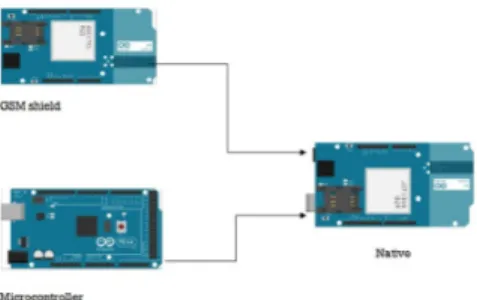
Fig. 1. Nautical prototype
The Nautical device consists of three modules shown in Figure 1, the GPS module, GSM module and microcontroller. The main purpose of the Nautical device is to capture the NMEA sentences, filter the sentences (like Latitude and longitude) and transfer these parameters to the web server through the GSM module with the help of microcontroller.
The Native prototype shown in Figure 2, is similar to the Nautical but it does not has a GPS module. The Native is purposely designed to provide the current location informa-tion from the web server to the GSM module with the help of the microcontroller.
Fig. 2. Native prototype
B. Native prototype
IV. HARDWARE
The Nautical apparatus consist of three important modules which are the GPS (Global Positioning System) , GSM (Global System for Mobile Communications) and the Micro-controller. Similar to Nautical, Native apparatus also consist only two modules (GSM and microcontroller ). The duties of each modules are very unique. The operation of each modules are explained below:
A. GPS Receiver
A GPS is made up of constellation of satellites orbiting around Earth. Each satellite has a atomic clock on its board, so it knows the precise time. As it is orbiting around the Earth, each satellite is continuously transmitting its location at 1.575 GHz. With the help of GPS receiver pointing at the sky, we can listen to these transmissions. When listening to 3 or more satellites transmissions, we can triangulate our location on earth. If a fourth satellite is available, we can even get the altitude. Here we use GPS provided by Adafruit Industries[11] which is is a low power module that draws only 20mA current, half of most GPS’s. The GPS has -165 dBm sensitivity, 10 Hz updates, 66 channels and has both Internal patch antenna as well as connector for external active antenna. We need to set a soft serial connection. The soft serial connection works by setting up a secondary UART on two pins which are Rx for Digital pin 7 and Tx for digital pin 8. Finally, with the help of the GPS receiver we could find the following:
• Location
• Latitude and Longitude • Altitude
• Speed B. GSM Shield
A GSM is a protocol developed by the European Telecom-munication Standard Institute (ETSI) for the second genera-tion (2G) digital cellular networks. In our applicagenera-tion, we use a GSM shield from Arduino[12]. The shield has radio mo-dem M10 by Quectel. The momo-dem in the GSM shield uses AT commands[13] to communicate with other device. The M10 is a Quad-band GSM/GPRS modem that works at the fre-quencies GSM850MHz, GSM900MHz, DCS1800MHz and PCS1900MHz. It supports TCP/UDP and HTTP protocols
through a GPRS connection. GPRS data down-link and up-link transfer speed is 85.6 kbps. The GSM module can help in make/receive voice calls, send/receive SMS messages and allows to connect with the Internet through GPRS wireless network. A SIM card is very essential for the GSM module to operate. The GSM shield communication data rate in bits per second (baud) for the serial port is 9600 bps. Here, the GSM module uses GSM Rx for digital pin 2, GSM Tx for digital pin 3 and Modem reset as digital Pin 7. As there is a pin overlap with GSM Modem reset pin 7 with GPS Rx digital pin 7, It’s necessary to cut the trace of one of the pin and with the help of jumper wires, we can redirect to another digital pin (we used pin 8 in GPS module). C. Microcontroller
For our application we use Arduino MEGA and UNO[12] with Atmel microcontrollers ATmega2560 and Atmega328 for Nautical and Native respectively. Arduino plays an impor-tant role in controlling the application. A software program written in C programming language is compiled, then stored in the flash memory of the microcontrollers. For MEGA, flash memory is 256 KB of which 8 KB used by bootloader and for UNO, 32 KB of which 0.5 KB used by bootloader.
V. SOFTWARE
This section provides a brief overview of the software application used by VERTIGUO.
A. Web server
We designed a web page with PHP code that will receive GPS information from the Nautical device and uploads to the server database. In the server, we use MySQL database and to connect to the database, we use mysqli connect command. Once the connection is successfully established, we need to insert the values by using MySQL query shown below :
$sql = "INSERT INTO tracer (Fix, Quality, Latdirection, Latvalue, Londirection, Lonvalue, Speed, Altitude, Satellites) VALUES (’$fix’,’$quality’,
’$latdirection’,’$latvalue’,
’$londirection’, ’$lonvalue’,’$speed’, ’$altitude’, ’$satellites’)";
Once the table is ready in the database, we can program the Nautical device to redirect the GPS values received from the satellite to this PHP file.
B. Google API
We have developed a web application utilizing the Google API [14] for Google Maps, that is specifically geared towards tracking the location of vehicles. The web application can be customized based on our requirements. Figure 3 shows the web tracking application that was developed as part of VERTIGUO project. This platform uses the location information in the database and plots the journey on Google Maps using the Google API.
Fig. 3. Web tracking using Google API for our field trial
Fig. 4. System architecture
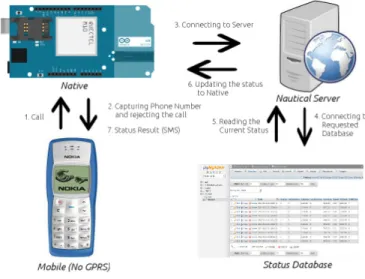
VI. SYSTEMARCHITECTURE
The architecture represented in Figure 4, describes the structure and blocks present in VERTIGUO. The Nautical device starts by sending the current location packets captured from GPS receiver through the GSM shield to the web server. The primary function of the web server is to store, process, retrieve and display the information present/given in/to the database . The web server consist of multiple databases, where each vehicle represents one database. Each database has two tables called the Tracer and the Spotter (Spotter is currently implemented as file). For every 5 minutes (can be configurable), the Tracer table helps in storing all the information like date, time, latitude, longitude,altitude and speed sent from GSM module. On the other hand, the Spotter is used to capture the current latitude and current longitude values from the Tracer table and identifies the location name. That is, when there is a new stimulus in the Tracer table, then the Spotter updates the current location name automatically. Now, to identify the exact location and the
previously navigated path, we use the Tracker. The tracker is a virtual interface integrated with Google API, that represents the location of the vehicle through maps. All smartphones and other personal devices connected with Internet can view these maps. However, not all the people are equipped with smartphones. Hence, to make this application serve for the other half, we built the Native prototype. Here, the end user, with a basic handset gives a request by calling to the Native. The Native will response to the call by sending the current vehicle location information from the Spotter to the end user through an SMS.
VII. APPLICATION FLOW
Fig. 5. Nautical flow
The operation begins when the Nautical is placed in the bus and powered with 5V. Then the Nautical device will start to sense the raw GPS NMEA sentences like the one below
$GPRMC,194509.000,A,4042.6142,N, 07400.4168,W,2.03,221.11,160412,A*77
Time/ active/ Latitude/direction/ Longitude/direction/speed/
True course/Date/checksum
Here we have taken almost all the information from the NEMA sentence. Once the data is received from GPS as shown in Figure 5, the microcontroller will introduce these information to GSM module. The GSM module will then initiate a GPRS wireless connection. Once the GPRS network is connected, all these data will be transmitted to the database through a web server(Nautical Server) with the help of IP address, path and the port number of the web server.
char server[] = "IP address/domain.com"; char path[] = "/tracegps.php";
int port = 80; // default port for HTTP
Once the connection is successful, it is very simple to store these GPS information in the database with the help of
PHP programing. Once the current location is updated in the Tracer table, the spotter will copy the Tracer table’s current location. Finally, with the help of the latitude and longitude details from the tracer table, we can identify virtually, the exact location of the vehicle by integrating with the google maps.
We have satisfied our application for commuters who use a smartphone with Internet facility available on their handset. But our system’s intension is to satisfy all the commuters who do not have a smart phone and Internet facility(called a basic set) and this is possible with help of Native prototype.
Fig. 6. Native flow
The Native acts as an intermediate between the web server and the basic handset. The commuters who use the basic handset are mostly interested in knowing about the current location where the bus is traveling. So to make this possible, we created a separate file/table in the Database called the Spotter or Status DB. Here the Spotter just keeps updating whenever there is a new stimulus in the Trace table.
So, the work flow is explained as in the Figure 6. The operation for the Native starts by dialing a number(Native’s phone number) from basic handset. When the Native receives the call from end user, it just captures the phone number and rejects the call. As the Native is always connected with the Internet, it connects to web server and looks the Spotter in the database and provides the current location name to the GSM module. Then the GSM module will respond to the end user by sending the current location details via an SMS. Hence from this design, all the commuters will be facilitated to use this application very efficiently.
VIII. TESTBED
Figure 7 shows the picture of our testbed. IX. OTHER APPLICATIONS
The VERTIGUO project can be harnessed with minimal changes to suit different applications as well :
• Parents send their kids to school or college through bus which can get delayed or turn up much early. With the
Fig. 7. Testbed
aid of our application we can identify the exact location of the bus and travel our journey accordingly.
• Our applications can help parents who are worried about their children traveling long distances from work location to their home.
• This application would be a boon for the tracking cabs, dynamic courier tracking, goods carrying vehicles and may more.
By exploiting the minimal HW requirements of the mobile phones, our design is not only available for the user who travels in the bus, but also for people who can track the expected arrival time of the user.
X. RESULT
In this section, we discuss the results obtained during one of our field trials. The HW prototype was allowed to cover a distance of around 15km from Ooty town to Nundhala village. Through out the course of the journey, the location updates of the HW prototype was send to the Nautical server through the GPS in Nautical.
Fig. 8. Database imprint showing the parameters provided by the HW
The data obtained in the database is shown in the Figure 8. Figure 9, shows the location updates that can be tracked either through the web interface or can be fetched by the Native server and delivered to an user through SMS. The frequency of the location update from the HW was chosen such that the database doesn’t get overloaded with redundant information. Moreover, since the trial was conducted in the hilly terrain, the rate at which distance covered is also less. Hence in this way we can accurately characterize the HW.
One of the important features of our prototype is the ac-curacy of the HW, which relates to the co-ordinates provided
Fig. 9. Tracking through GSM phone and Web interface
Fig. 10. Satellite coverage Vs Altitude
by the GPS. In our trial, we observed the number of satellites covered as we moved through different altitude. Figure 10 shows the number of satellite covered (along X-axis) against the altitude in meters (along Y-axis).Since the geographical location chosen for the field trial is high altitude hilly region covered with forest, there were some slight deviation in the number of satellite observed. One such signal deviation can be observed for the altitude of 2261.7m where the number of satellites observed is dropped to 6 due to the signal interruption when passing through the forest. For the remaing part of the graph, the satellite coverage is good.
Fig. 11. Dynamic speed Vs Time
Figure 11, shows the plot for the dynamic variation of the bus speed (in km/hr along Y-axis) against the time (along X-axis). The initial value is 0 km/hr when the bus is in the halt state during the first 10 minutes. As the bus starts and move along its destination, we can see a smooth
exponential curve extending through most of the time. Since the bus didn’t stop in the middle, there are no sudden dips observed. As we reach towards our destination, there is a linear decrease in the speed and grounds to halt (0 km/hr) when the destination is reached. Through this feature, we can track the location of an object of interest as well as estimate the arrival/estimated arrival time. In future, we are also planning to develop algorithms that can interpret the arrival time of the bus based on the traffic and climatic conditions.
XI. CONCLUSION
In this work we have developed VERTIGUO - an open source Vehicular tracking system that is flexible, affordable, customizable and accurate. We have described our complete solution containing a HW prototype and user friendly SW application. Through this technology, we enable people to track information about the transportation service and lever-age the open source platform to customize the HW and SW to their requirements. There can be various other application that can be built over our existing platform. We have also demonstrated the credibility of the design through field trials and the initial results obtained through our prototype are very promising.
REFERENCES
[1] Ramadan, M., M. Al-Khedher, and S. Al-Kheder. Intelligent anti-theft and tracking system for automobiles. Int. J. Mach. Learn. Computing (2012)
[2] Mohammad A. Al-Khedher, Hybrid GPS-GSM Localization of Auto-mobile Tracking System, IJCSIT Vol 3, No 6, Dec 2011
[3] R.Ramani, S.Valarmathy, N.SuthanthiraVanitha, S.Selvaraju, and M.Thiruppathi, Vehicle Tracking and Locking Sytem Based on GSM and GPS, I.J. Intelligent Systems and Applications, 2013, 09, 86-93 [4] Salim, Khalifa A., and I.M. Idrees. Design and Implementation of
Web-Based GPS-GPRS Vehicle Tracking System. IJCSET Dec (2013). [5] N. Chadil, A. Russameesawang, and P. Keeratiwintakorn, Real-Time Tracking Management System using GPS, GPRS and Google Earth, in Proc of the 5th ICoEETIT, Thailand, 2008.
[6] A. ElShafee, M. EIMenshawi, and M. Saeed, Integrating Social Network Services with Vehicle Tracking Technologies, International Journal of Advanced Computer Science and Applications,Vol. 4, No. 6, 2013
[7] SeokJu Lee; Tewolde, G.; Jaerock Kwon, Design and implementation of vehicle tracking system using GPS/GSM/GPRS technology and smartphone application, Internet of Things (WF-IoT), 2014 IEEE World Forum on , vol., no., pp.353,358, 6-8 March 2014
[8] G. Kiran Kumar, A. Mallikarjuna Prasad, Public Transportation Mangement Service using GPS-GSM, International Journal of Re-search in Computer and Communication Technology, IJRCCT, ISSN-2278-5841, Vol-1, Issue -3, Aug - 2012.
[9] Zhu Yongjun; Zhu Xueli; Zhu Shuxian; Guo shenghui, Intelligent transportation system based on Internet of Things, WAC, 2012 , vol., no., pp.1,3, 24-28 June 2012
[10] Kumar, R.; Kumar, H., Availability and handling of data recived through GPS device: IACC, 2014 IEEE International , vol., no., pp.245,249, 21-22 Feb. 2014
[11] GPS module https://www.adafruit.com/
[12] Arduino microcontrollers and GSM shield http://www.arduino.cc/ [13] http://arduino.cc/en/uploads/Main/Quectel M10 AT commands.pdf
[14] ”The Google Directions API” ,
https://developers.google.com/maps/documentation/directions/ [15] ”Scaling Mobile for Development”,
https://gsmaintelligence.com/files/analysis/?file=130828-scaling-mobile.pdf
[16] ”Intelligent Transporation Systems”, http://manihattysemiconductors.com/gps/home.html