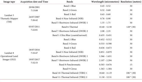
Evaluation of Land Use & Land Cover Change Using Multi Temporal Landsat Imagery: A Case Study Sulaimaniyah Governorate, Iraq
Full text
Figure


Related documents
Hybrid Architecture for Pervasive Computing Supported Collaborative Work. Application and
In terms of periodicity of observed temporal patterns of entity dynamics, most entities change on a year-cycle with small amount of changes.. The result of the analysis shown in
“Conversion of non-electrical properties into usable electrical signals and the control of machines and motor drives are also key topics, in the training of mechatronics engineers
There is evidence to suggest that patients may even develop cataracts due to hypocalcemia that causes no signs or symptoms of increased neuromuscular irritability.1 It might be
While electronic clinical quality measurement (eCQM) automation by U.S. hospitals is progressing, significant barriers remain. After identifying U.S. hospital characteristics
The objective of the placement department at Krupanidhi College is to work with the students and help them achieve their professional goals, explore their individual strengths,
From its inception, it has operated without a mayor, council, or city manager and instead has derived public services from special districts (primarily the Metro Districts,
Hence, the final Sinhala lexicon (adjective and adverb list) obtained without POS but with positive and negative sentiment scores same as the corresponding English word
