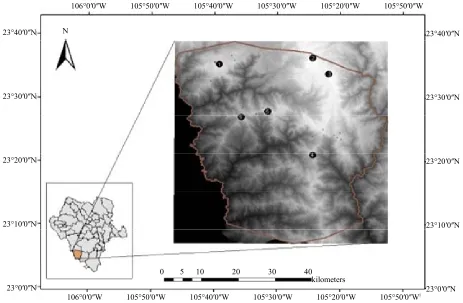
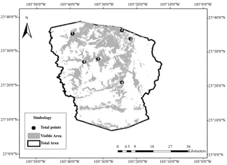
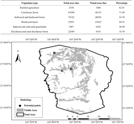
Geospatial Model as Strategy to Prevent Forest Fires: A Case Study
Full text
Figure
Related documents
Experiments were designed with different ecological conditions like prey density, volume of water, container shape, presence of vegetation, predator density and time of
The single variable beam theories taking into account effect of transverse shear deformation for the buckling, bending and free vibration analysis of the thick beam
When organizational changes occur, people become confused, and resist the changing conditions; however, those with high AQ quickly adapt themselves to new conditions and
It can be seen that single electroless Ni coating has a ‘cauliflower-like’ structure (Figure 2a), including a few micro cracks marked in the figure. These defects can
In March 2015, the Substance Abuse and Mental Health Services Administration’s (SAMHSA) Office of Behavioral Health Equity (OBHE) and the American Psychological
Although we found an inverse relation between participants’ HRQoL estimates (EQ-5D-5L and QoL-AD) and the severity of the AD, each participant provided HRQoL estimates for a
Roilides E, et al : Disseminated infection due to Chrysosporium zonatum in a patient with chronic granulomatous disease and review of non- Aspergillus fungal infections in patients
In absence of a scientific basis for such a policy, this study will assess the effects and costs of screening for and treatment of unsuspected intrauterine abnormalities by
