Bachelor Thesis
Farming practices and their
water use in the
Getas-Ngandong Forests
Towards a better understanding of stakeholders’ perceptions of the effects of agroforestry and monocropping systems on water use
Rhodé Rijneveld
Bachelor Thesis
Farming practices and their water use in the
Getas-Ngandong Forests
Towards a better understanding of stakeholders’ perceptions
of the effects of agroforestry
and monocropping systems on water use
Submitted by:
Rhodé Rijneveld
Civil Engineering
Supervisor University of Twente:
Dr. Ir. M. J. Booij
Supervisor Universitas Gadjah Mada:
Dr. H. Marhaento
i
PREFACE
In front of you lies the outcome of the bachelor thesis project that is part of the civil engineering bachelor of University of Twente. Almost one year ago, the preparations for this project started. I wanted to do a project related to water management in a non-European country to experience working in a different culture. I combined this project with an internship at the Watershed Office in Solo, which was part of the minor ‘Crossing Borders’. This combination increased the flexibility for the planning of the field study for the thesis project.
This bachelor thesis would not have been possible without the help of many people. I went to Indonesia alone, but there were so many people who helped me with administrative issues to practical and technical issues. I am very thankful for everyone who helped me with some part of my stay in Indonesia.
Special thanks to Mbak Judith, for helping me with the visa procedures during my first week in Jakarta. Special thanks to Rian and Azis for assisting me during the field study in Getas. Special thanks to Dr. H. Marhaento for supervising me at the Gadjah Mada University, for giving feedback at several occasions, and for organising the field study so well. Special thanks to Dr. Ir. M. J. Booij for supervising me at University of Twente. I also want to thank all my friends in Yogyakarta who supported me and showed me around in their beautiful country.
Terima Kasih!
ii
SUMMARY
In 2017 the government of Indonesia entrusted the Getas-Ngandong forests (also referred to as KHDTK), located on Java, Indonesia, to be managed by UGM from 2017 to 2037. The area is utilised for the planting of teak and for farming. Local farmers use both agroforestry and monocropping systems to cultivate their crops. However, in the current situation, they are threatened by water-related problems, such as unreliable water availability, droughts, and floods. Consequently, it is crucial to correctly manage the water use of farming practices to maximise their productivity and efficiency. Because stakeholders’ involvement is needed, considering their perceptions is relevant to planning actions for the management and development of KHDTK. This project describes the current situation of the farming practices and it then identifies stakeholder perceptions on the water issue to contribute to the management and development of KHDTK.
The study area of this thesis project consists of the village area of Getas and Pitu covering 32% of the KHDTK area. The farming communities in both Getas and Pitu have a high dependency on state forests. In Getas, most agroforestry systems are applied in state forests. However, Pitu depends less on state forests and applies agroforestry systems in both state forests and community-owned forests. In both Getas and Pitu maize, sugarcane, and rice are the most grown crops in agroforestry systems and monocropping systems. Furthermore, farmers in Getas and Pitu generally have a rainfed agriculture. Thus, during the dry season or periods of drought, there is often no farming activity, unless farmers use irrigation systems. Consequently, in the rainy season the attitude to water availability is positive and in the dry season primarily negative. However, the presence of springs provides opportunities to use irrigation systems in both areas, but farmers in Pitu can also irrigate from the Bengawan Solo river. This partly accounts for the more positive attitude of Pitu farmers compared to Getas farmers to general water availability. Additionally, crops such as maize and sugarcane are generally cultivated on hilly areas, so floods do not influence these farming lands. Farmers tend to plant wet rice fields in monocropping systems in valleys or near flood sensitive rivers while dry rice fields are often cultivated in agroforestry systems. Consequently, lands with monocropping systems are situated closer to a river and thus farmers with monocropping systems have a more positive attitude towards water availability than farmers with agroforestry systems.
The key stakeholders that are related to the water issues in the study area are the village communities of Getas and Pitu, the local governments, the previous and current managers of the area, and the watershed office. Among all stakeholders there is consensus on some hydrological benefits of agroforestry systems, such as increased regional water availability, and reduced risk of floods and surface runoff. Also, there is a general confidence that trees and crops do not compete for available soil water. Beyond this consensus, three perceptions are identified that express distinct attitudes regarding the water use of farming practices. The first perception strongly states that monocropping systems have a higher water use than agroforestry systems, while the second perception states the opposite. The third perception is reluctant to assign the extent of water use to a specific system, and states that factors such as species and planting pattern define water use. Furthermore, the first and third perception are confident that agroforestry systems are a good application for soil and water conservation, yet the second perception reveals a more sceptical attitude. Each stakeholder group represents two or even all three perceptions. Thus, within and between stakeholder groups there are contradicting beliefs of the effects of agroforestry and monocropping systems on water use.
iii them from changing forest areas into monoculture areas. However, it should be very clear to the farming communities why the conservative benefits of agroforestry systems are surpassing the disadvantages of a higher water use and subsequent lower crop yield.
iv
TABLE OF CONTENTS
PREFACE ... i
SUMMARY ... ii
TABLE OF CONTENTS ... iv
LIST OF ABBREVIATIONS ... vi
1. INTRODUCTION ... 1
1.1. Problem context ... 1
1.2. State of the art ... 1
1.3. Objective and research question ... 4
1.4. Thesis structure ... 4
2. FARMING PRACTICES AND WATER AVAILABILITY ... 5
2.1. Methodology ... 5
2.2. The study area ... 5
2.3. The farming practices... 7
2.4. Water availability in the farming lands ... 9
2.5. Discussion ... 11
2.6. Conclusion ... 11
3. STAKEHOLDERS’ PERCEPTIONS ... 13
3.1. Methodology ... 13
3.2. Key stakeholders ... 14
3.3. The perceptions ... 15
3.4. Distribution of perceptions within stakeholder groups ... 20
3.5. Discussion ... 21
3.6. Conclusion ... 22
4. CONSIDERATIONS FOR MANAGEMENT AND DEVELOPMENT ... 23
4.1. Methodology ... 23
4.2. Common basis ... 23
4.3. Focus points ... 23
4.4. Discussion ... 24
4.5. Conclusion ... 24
5. CONCLUSIONS AND RECOMMENDATIONS ... 25
5.1. Conclusion ... 25
5.2. Recommendations ... 27
REFERENCES ... 28
Appendix A: Administrative regions in KHDTK ... 30
Appendix B: Water use interviews ... 31
B.1. Preparations and procedure ... 31
B.2. Interview format ... 31
Appendix C: Q methodology – an introduction ... 33
C.1. Elicitation methods ... 33
C.2. Q methodology ... 33
C.3. Q in forestry, agriculture, and hydrology ... 34
Appendix D: Q methodology – step by step strategy ... 35
D.1. Research design ... 35
v
D.3.Analysis ... 37
Appendix E: Perception FGD and interview format ... 42
E.1. FGD format ... 42
E.2. Interview format ... 45
vi
LIST OF ABBREVIATIONS
Term Explanation
BPDASHL Solo Balai Pengelolaan Daerah Aliran Sungai dan Hutan Lindung Solo
FAO Food and Agricultural Organisation
FGD Focus group discussion
GIS Geographic Information System
HPD Hutan Pangkuan Desa
KHDTK Kawasan Hutan Dengan Tujuan Khusus
LMDH Lembaga Masyarakat Desa Hutan
PCA Principal Component Analysis
PHBM Pengelolaan Sumber daya Hutan Bersama Masyarakat
RPH Resort Pemangkuan Hutan
UGM Universitas Gadjah Mada
1
1.
INTRODUCTION
This introductory chapter presents the problem context in section 1.1. Section 1.2 then presents the state of the art and section 1.3 the research aim and the research questions of this thesis project. Lastly, sub chapter 1.4 gives an overview of the structure of the report.
1.1.
Problem context
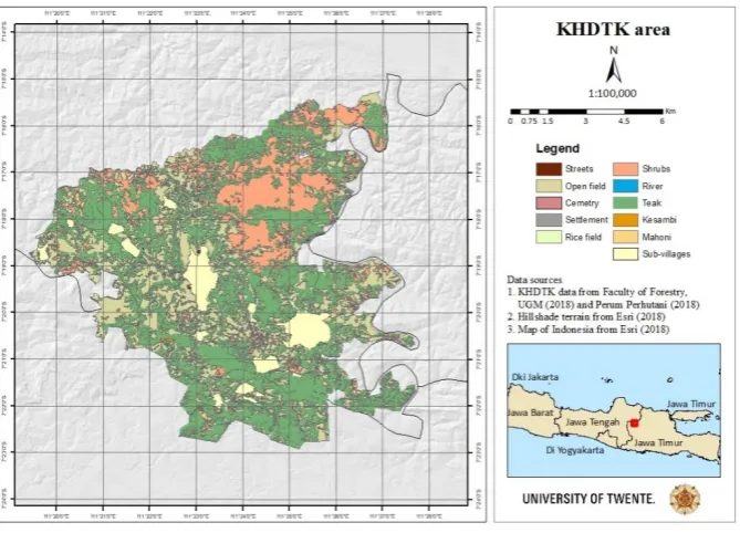
[image:9.595.76.411.309.550.2]In 2017 the government of Indonesia entrusted the Getas-Ngandong forests, located on Java, Indonesia, to be managed by Universitas Gadjah Mada (UGM) from 2017 to 2037. The Getas-Ngandong forest, also referred to as KHDTK (forest area with special objectives) has an area of roughly 11,000 hectares; see Figure 1. It is located in two districts and two provinces, namely Blora District, Central Java and Ngawi District, East Java. For an explanation of the administrative regions of Indonesia, see Appendix A. The KHDTK area is utilised for the planting of teak and for farming. Local farmers use both agroforestry systems and monocropping systems to cultivate their crops. However, in the current situation, they are threatened by water-related problems, such as unreliable water availability, droughts, and floods. Consequently, it is crucial to correctly manage the farming practices and their water use to maximise their productivity and efficiency.
Figure 1: The KHDTK area.
1.2.
State of the art
The topic of this thesis project covers the fields of (tropical) forestry, hydrology, and agriculture. To describe the state of all these fields with its current positions and recent (scientific) developments would be an immense study. Therefore, only the overlapping topics will be explored. Firstly, the hydrological aspects of forests will be explored followed by the hydrological aspects of farming practices.
Hydrological aspects of tropical forests
2 under constant debate (Calder, 1998; Ellison, Futter, & Bishop, 2012). In general, two perspectives, both with the fundamental assertion that trees use water, on forests and its hydrological aspects can be distinguished.
One view, which is sometimes referred to as the ‘supply-side’ of the debate, suggests that increasing forest cover raises the water yield and improves water availability at the regional and/or global scale. This is because this perspective of the role of forests is that forests act as a sponge. The tree roots, forest litter, and soil act as a sponge and some even claim that the tree roots release the water, that was soaked in during the wet season, evenly during the dry season. This sponge effect will maintain the water supplies during the year (Bruijnzeel, 2004; Ellison et al., 2012).
The other view is presented by the ‘demand-side’ of the debate, regarding forests as consumers of available water and competitors for other water uses, such as agriculture. A claim in this perspective is that roots should be considered as pumps rather than sponges and that roots do not release water during the dry season but instead remove it from the soil for the trees to grow (Hamilton, 1983). According to Bruijnzeel, nowadays there seems to be a growing tendency to emphasise on the more negative aspects of forests such as their higher water use and their inability to prevent extreme floods rather than their protective values such as enhanced water quality, moderation of most peak flows and carbon sequestration (Bruijnzeel, 2004).
The beforementioned views are part of the outcomes of extensive research that has taken place in the past half century to understand the nature and dynamics of hydrological processes in tropical catchments. Currently, a solid body of scientific information for interpreting the relationships between water and forests in tropical regions is available. However, there are still the two perspectives on the role of forests that sometimes contradict each other. Some even attribute debate over the outcome of increased forest cover on water yield to the gap between public perceptions and scientific knowledge (Calder, 1998; Gilmour, 2014).
Agriculture and its hydrological aspects
The FAO has predicted that the food production must increase by 70% by 2050 to meet the needs of a growing world population (FAO, 2009). This will cause several problems, one of them being an intensification of existing agricultural practices (Smith, Pearce, & Wolfe, 2013). More than 30% of the land cover of Indonesia is defined as agricultural land, thus providing many opportunities for optimising its agricultural practices (Central Intelligence Agency, 2018).
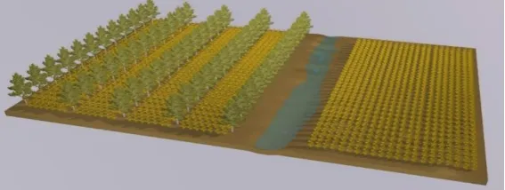
[image:10.595.72.356.562.669.2]The agricultural practices distinguished in this thesis project are agroforestry systems and monocropping systems. Agroforestry is defined as a land-use system in which woody perennials (trees, shrubs, etc.) are grown in association with agricultural crops, pastures, or livestock, in a spatial arrangement, a rotation or both (Nair, 1993). Monocropping consists of cultivating one type of crop on the same land. See Figure 2 for a visualisation of these systems.
Figure 2: An agroforestry system on the left and a monocropping system on the right (Yuwono et al., 2018).
Agroforestry systems versus monocropping
3 sequestration (Jose, 2009). Agroforestry is an acceptable practice in sustaining the hydrological cycle and providing a reliable tool for soil and water conservation in a watershed (Idris & Mahrup, 2017). However, the complex relationship between soil water content, rainfall, water uptake by plants and evapotranspiration throughout the seasons makes it extremely difficult to fully understand water dynamics within an agroforestry system. Some hydrological components of agroforestry systems are: - Through water tapping and prevention of nutrient leaching, trees help recover nutrient,
conserve soil moisture and improve soil organic matter (Mbow et al., 2014).
- The addition of trees to a monocropping system may increase the water-use of the system directly, by increased rainfall utilization compared to annual cropping systems (Jackson, Wallace, & Ong, 2000; Mbow et al., 2014).
- Increased plant water use can also occur indirectly through a modification of the crop micro-climate (due to shade effects for example) so that less water is lost through soil evaporation, and hence more is available for tree and crop transpiration (Jackson et al., 2000; Smith et al., 2013).
- River bank buffers and other agroforestry systems can help reduce runoff and increase infiltration (Smith et al., 2013).
- Also, with the prediction of an increase in natural hazards and extreme events (such as flooding and droughts) due to climate change, increasing the number of trees in a landscape can reduce the impact on the farming systems since the trees act as buffers. In agroforestry systems, the surface runoff is reduced and there is an increased infiltration and soil water holding capacity. Therefore, the risk of flash flooding after periods of heavy rainfall is reduced (Smith et al., 2013).
Thus, in agroforestry systems the water-use of the overall system will increase. Next, the competition between trees and crops for available soil water must be minimised since water availability is a main factor of determining the success of an agroforestry system. Consequently, this leads to compromises such as reduced crop yield compared to monocropping systems, if the trees are allowed to grow large enough to utilise soil water otherwise lost through drainage (Jackson et al., 2000). However, this complementarity between trees and annual crops makes soil resource utilization more efficient than in monocropping systems (Mbow et al., 2014).
In the last few decades, extensive research has been done in the fields of forestry, hydrology, and agriculture. There is a solid scientific body for interpreting the hydrological role of tropical forests, although the scientific community is divided in its perceptions of the hydrological function of trees (Gilmour, 2014). In addition, many point out that additional evidence for the hydrological claims and products of agroforestry systems should be found to affirm these claims (Jackson et al., 2000; Jose, 2009; Mbow et al., 2014). This indicates that, although many studies have been done in the fields of forestry, hydrology and agriculture, there is a general need for further research in the future to specific claims and functions.
4 align the interests of all stakeholders (Guthiga, 2008; Hutton & Leader-Williams, 2003). Thus, involving stakeholders in forest management decisions is crucial to the success of these programmes (Silvano, Udvardy, Ceroni, & Farley, 2005).
1.3.
Objective and research question
KHDTK forest management aims to maximise the productivity and efficiency of the forest and forest-farming systems to increase community welfare. This objective will be achieved by including research activities and participation of all stakeholders in the management and development of KHDTK. In KHDTK, local farmers use both agroforestry systems and monocropping systems, but they are threatened by water-related problems. This thesis project will describe the current situation of the farming practices and the water availability in the farming lands. It will then explore stakeholder perceptions on the water issue to contribute to the management and development of KHDTK. Thus, the research aim is:
Identify farming practices in the Getas-Ngandong forests and compare the perceptions of key stakeholders on the effects of agroforestry and monocropping systems on the water use in the farming lands to contribute to the development and management of the area
The research questions that will contribute to the research aim are:
1. How can the farming practices and the water availability in the study area be described? 1.1. How are the farming lands currently used?
1.2. How can the water availability in the farming lands be described?
2. What are the perceptions of the key stakeholders on the effects of different farming practices on the water use in the farming lands?
2.1. Who are the key stakeholders?
2.2. To what extent are the varying farming practices different in their water use according to the stakeholders?
2.3. To what extent are the perceptions represented within stakeholder groups? 3. What are considerations for future management and development of the study area?
3.1. What is the common basis? 3.2. What are focus points?
1.4.
Thesis structure
5
2.
FARMING PRACTICES AND WATER AVAILABILITY
This chapter gives an answer to the first research question: ‘How can the farming practices and the water availability in the study area be described?’. Section 2.1 first describes the methodology. Section 2.2 then shows several characteristics of the study area, including climate, land cover and population characteristics. Next, section 2.3 explores the current use of the farming lands through an analysis of different types of land ownership and farming practices. Then, section 2.4 describes the water availability in the farming lands. Following, section 2.5 and 2.6 give a discussion and conclusion.
2.1.
Methodology
Firstly, general characteristics of the study area were obtained by studying the management report of the KHDTK area (Yuwono et al., 2018). Also, current spatial data of the KHDTK area was analysed in GIS-software (Geographic Information System) for the specific study area. Next, a sampling design was made to identify the type of crops, the farming practices, and the water availability in the study area. Based on resource and time constraints, the maximum number of samples was chosen to be 12, of which 6 sites represented agroforestry systems and 6 sites represented monocropping systems. A local counsellor determined these 12 locations, ensuring that the samples were representative for the study area. At each location observations of the crops and farming practice were done, and the farmer was interviewed on the water availability in the farming land. Farmers were questioned on their attitudes towards water availability and issues such as the source of water for the farming lands and the occurrence of floods and droughts. See Appendix B for the interview preparations, procedures, and the format. The data was then processed and analysed using Excel.
2.2.
The study area
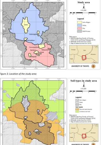
[image:13.595.72.526.531.577.2]The KHDTK area is located in two districts and two provinces, namely Blora District, Central Java (roughly 80%) and Ngawi District, East Java (roughly 20%). The area contains 15 villages; 9 villages are situated in the Kredenan, Randublatung and Jati subdistricts in the Blora district and 6 villages are situated in the Pitu subdistrict in the Ngawi district. The study area of this thesis project consists of the village area of Getas and Pitu (see Figure 3). These villages were chosen, because the farmers cultivate their crops in different ways and the two villages are located in two different districts. Table 1 shows an overview of the administrative regions of these villages. The village areas are defined by UGM management boundaries. Consequently, they differ from the official village areas. See Appendix A for an explanation and visualisation of these different types of boundaries.
Table 1: Districts and size of the two villages.
Village Sub-district District Province Area (ha) Percentage of KHDTK
Getas Kradenan Blora Central Java 2265 21%
Pitu Pitu Ngawi East Java 1214 11%
Climate and soil type
Most of the UGM KHDTK area has 2000-2400 mm of rainfall per year in the D (moderate) climate category based on Schmidt-Fergusson (Yuwono et al., 2018). This climate classification method is based on the ratio of dry months (<60 mm) to wet months (>100 mm), expressed as a percentage. Category D has a ratio of 60 – 100 %. The rainy season lasts from November to March and the dry season lasts from April to October.
6
Figure 3: Location of the study area
Figure 4: Soil types in the study area.
Land cover
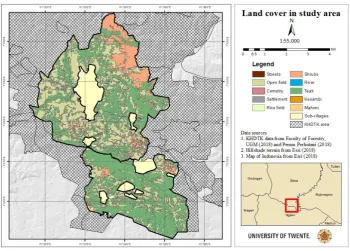
7
Figure 5: Land cover in the study area.
The population
Both Getas and Pitu have a population of almost 5000 people (as measured in 2015). The livelihoods of forest village communities are mostly farmers and farm laborers (83%), who cultivate crops or have livestock. Other livelihoods are civil servants, private employees, entrepreneurs, and non-agricultural workers. 99% of the population is Muslim (Yuwono et al., 2018).
2.3.
The farming practices
The current use of the farming lands was explored through a study of the management report and a field study. Firstly, this chapter describes the land ownership in both villages. Following, it shows the sampling locations in the study. The farming practices are described through an analysis of the sampled locations and through additional observations in the study area.
Land ownership
8
Agroforestry and monocropping systems
[image:16.595.73.394.158.384.2]A sampling design was made to identify the type of crops, the farming practices and water use in the area. Based on resource and time constraints, 12 sample locations were chosen throughout the area. In both Getas and Pitu, 3 locations represent an agroforestry system and 3 locations represent a monocropping system. Furthermore, additional observations were done to provide deeper insights. Figure 6 shows an overview of the sample locations in the area.
Figure 6: Sample locations in the study area.
[image:16.595.73.524.498.697.2]The locations were chosen by a local counsellor and this ensures a variety of locations, even if the samples are not spatially balanced. One of the sample locations is situated outside the UGM management borders, although it is inside the official village area. The area is similar to the area in the UGM management area, so the sample will be acknowledged in the analysis of the study area. Table 2 presents an overview of the farming practices, the crops, and the age of the crops.
Table 2: An overview of the data obtained at the sample locations.
Sample Location Farming practice Type of crop Age of crop (months)
1 Getas Agroforestry Dry rice field 3.5
2 Getas Agroforestry Maize 2.3
3 Getas Agroforestry Maize 4
4 Getas Monocropping Wet rice field 0
5 Getas Monocropping Sugercane 2
6 Getas Monocropping Maize 4
7 Pitu Agroforestry Dry rice field 2
8 Pitu Agroforestry Maize 3.6
9 Pitu Agroforestry Maize 2
10 Pitu Monocropping Maize 3.5
11 Pitu Monocropping Wet rice field 3.2
12 Pitu Monocropping Maize 3
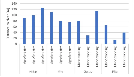
9 generally exist in state forests. However, in Pitu half of the agroforestry systems are in state forests and the other half in community forests. Moreover, the distance as the crow flies to the nearest river is determined for the sample locations; Figure 7 presents these findings.
Figure 7: Distance to the nearest river.
Generally, farming lands with monocropping systems are situated closer to a river than farming lands with agroforestry systems. Also, lands with agroforestry systems in Pitu are closer to a river than agroforestry lands in Getas, and this is similar for the monocropping systems. Although these rivers exist in the rainy season, they may be dry in the dry season depending on the presence of nearby springs or bigger rivers.
2.4.
Water availability in the farming lands
This section aims to describe the water availability in the farming lands in Getas and Pitu. Interviews were done with farmers in Getas and Pitu to obtain a first impression of the water availability and additional observations provided a deeper insight.
Interview results
In both villages 6 interviews were done with farmers. For the locations of their farming lands, see the sample locations in Figure 6. The interview explores practices of water use and attitudes towards water availability; see Appendix B for the interview format. The results of the interviews can be divided into three sub-topics:
- Attitudes towards water availability
- Location of water resources for the farming lands - Occurrence of floods and droughts
Each sub-topic will be analysed from two perspectives, namely by the farmers in Getas or Pitu and the farmers with agroforestry or monocropping systems.
Attitudes towards water availability
The attitudes towards water availability for the farming lands were investigated for general availability and availability during the rainy and dry season. See Figure 8 for an overview of these attitudes. The attitudes for general water availability in both perspectives are divided from slightly negative to quite positive, but farmers in Getas hold a more negative attitude than farmers in Pitu. This suggests that, generally, less water is available for the farming lands in Getas.
For the water availability in the rainy season, the farmers are positive in both villages and for both farming systems. However, Getas farmers are more explicitly positive than the Pitu farmers and farmers with agroforestry systems hold slightly more negative attitudes towards the water availability in the rainy season.
10
Figure 8: An overview of the attitudes towards water availability categorized by farmers in the same village and farmers with the same farming system (1= poor availability, 10 = good availability).
Location of water resources for the farming lands
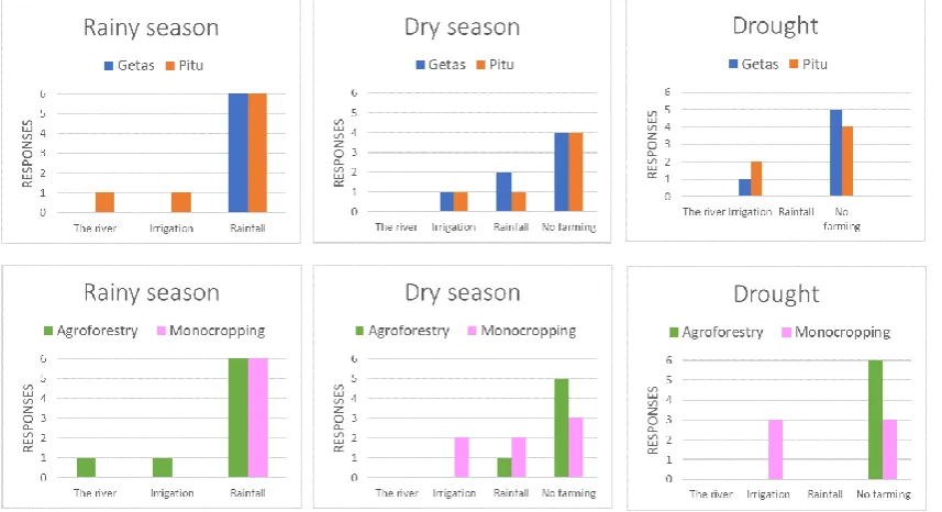
Secondly, the location of water resources for the farming lands was explored for the rainy season, dry season, and periods of drought. Periods of drought are defined as unexpected dryer periods apart from the dry season. Farmers using a river use surface water, while farmers applying irrigation systems use ground water. See Figure 9 for an overview of these results. Figure 9 illustrates that both perspectives are quite similar in how they obtain water for the farming lands. During the rainy season, farmers from both villages and with both farming practices are very dependent on rainfall. In the dry season, generally, farmers are still dependent on rainfall and therefore there is often no farming. However, some farmers with monocropping systems are less vulnerable to the dry season since they can use irrigation. During periods of drought, only farmers with irrigation systems can continue to grow crops.
[image:18.595.73.502.493.726.2]11
Occurrence of floods and droughts
[image:19.595.73.361.102.336.2]See Figure 10 for an overview of the occurrence of floods and droughts in the farming lands.
Figure 10: An overview of the occurrence of floods and droughts categorized by farmers in the same village and farmers with the same farming system.
In both villages and for both farming systems, there are generally no floods, and droughts occur once a year (which generally refers to the dry season). For farmers that do grow crops during droughts, farming becomes more expensive because of water transportation costs.
Additional observations
Additional observations show that both areas generally have a rainfed agriculture. However, Pitu farmers can also use irrigation from the Bengawan Solo river. Getas also has some tributaries from this river in its area, but they tend to be small and unreliable for farming since they are empty in the dry season and flooding in the rainy season. Both areas are hilly, and farmers tend to grow crops such as maize and sugarcane on the hills so that they are not influenced by floods. Wet rice fields are planted in valleys or near rivers that are more sensitive to floods. Furthermore, some rivers dry out in the dry season, depending on the presence of a spring in the vicinity. In Getas, there are roughly 5 springs, although only 3 do not dry out during the dry season and not all are available for the farming lands. In Pitu there are roughly 2 springs that do not dry out during the dry season.
2.5.
Discussion
The characteristics of the study area are described through the management report of KHDTK and the created maps. The management report is recently written, and the shape files are based on recent data. Thus, these data sources are a reliable source of information, which ensures a solid description of the area. Next, the findings presented in chapter 4.2 and 4.3 are mostly based on a field study. The sample size of this study is influenced by time and resource constraints, but these constraints more often determine sample size in land-use studies (Nusser & Klaas, 2003; Stein & Ettema, 2003). Then, generally, for a representative sample a spatially balanced design is often favoured to ensure spatial coverage of the entire survey area. However, in this study, a local counsellor chose the locations, since he could ensure a variety of farming lands in the study area. Nevertheless, additional observations were done to gain further insights of the study area.
2.6.
Conclusion
13
3.
STAKEHOLDER
S’ PERCEPTIONS
This chapter presents the findings of the second research question: ‘What are the perceptions of the key stakeholders on the effects of different farming practices on the water use in the farming lands?’ First, section 3.1 presents the methodology. Section 3.2 then identifies the key stakeholders and their roles. Next, section 3.3 presents the perceptions of the stakeholders. Following, section 3.4 investigates the distribution of the perceptions within and between stakeholder groups. Lastly, sections 3.5 and 3.6 give a discussion and conclusion.
3.1.
Methodology
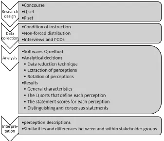
[image:21.595.75.413.268.557.2]Q methodology (hereafter referred to as Q) was applied to identify and analyse the stakeholders’ perceptions. Q is a clearly structured, systematic and increasingly-used methodology designed specifically to identify typologies of perceptions (Zabala, 2014). See Appendix C for an elaborate clarification of the choice of the method, the background of Q, and the use of Q in the fields of forestry, agriculture, and hydrology. See Figure 11 for an overview of the research process of Q.
Figure 11: Research process of Q, based on (Zabala, Sandbrook, & Mukherjee, 2018).
Firstly, 17 statements (the Q set) were created based on a literature review (the concourse). Section 1.2 presents this literature review that makes up the concourse of Q and Appendix D.1 presents the statements. After identifying the key stakeholders (the P set), interviews and focus group discussion (FGDs) were conducted with 33 respondents to collect the data. The number of respondents in Q studies (in conservation contexts) typically ranges from 26 to 46 (Zabala et al., 2018). Thus; the size of the P set in this study is average. The stakeholders could freely state their level of agreement for each statement on a five-level scale; see Figure 12. The ranked statements of a stakeholder are referred to as the Q sort.
☐ + + ☐ + ☐ ? ☐ - ☐ - -
+2 +1 0 -1 -2
14 Additionally, stakeholders could give a short reason for their choice. See Appendix E for the interview and FGD formats and Appendix D.2 for the procedures and collected data.
For the analysis the Qmethod package (Zabala, 2014) in R software was applied. The main reason for choosing this method is the clear and synthetic report on distinguishing and consensus statements. The analysis consists of two parts; the analytical decisions and the results. The Q sort was analysed through principal component analysis (PCA) to reduce all responses to 3 distinct perceptions representing those who share similar views. The number of perceptions to be extracted was determined through 3 criteria; see Appendix D.3. Next, varimax rotation is applied to obtain a clearer and simpler structure of the data. This rotation can be done either manually or mathematically, but Qmethod currently only allows mathematical rotation. Varimax is the most commonly used rotation (Zabala et al., 2018), so it is also applied in this study. Varimax rotation retains the assumption that the perceptions are orthogonal to each other and have unit variance while it attempts to minimize the number of variables with high loadings on each perception (Saigal, Borgoyary, & Lal, 2005).
Having determined the number of perceptions to extract, the analysis was run again. The results then consist of three components. Firstly, the extent to which a respondent represents a perception is called the loading of Q sorts. The higher a respondent’s loading on a perception, the more representative she is of that perception. QMethod then automatically assigns (i.e. flags) stakeholders to the perception with the highest loading. Automatic flagging is based on the two criteria that the loading should be significantly high and the square loading for a perception should be higher than the sum of the square loading for all other perceptions (Zabala, 2014). Secondly, the statement scores consist of the z-scores, which indicate the relation between statements and perceptions. They are a weighted average of the scores given by the Q sorts that represent that perception. Thirdly, distinguishing and consensus statements were obtained. The comparison of absolute differences between perception z-scores indicate whether a statement is consensus or distinguishing. A statement is consensus when there are similar z-scores across all perceptions and a statement distinguishes a perception if it has a significant different z-score compared with the other perceptions. Additional information on the methodology and results of the analysis can be found in Appendix D.
The final step of Q consists of the actual construction of the perceptions. Firstly, the perceptions were described through exploring the following results of the Qmethod analysis:
- The relative position of statements within the grid. Statements that are both distinctive and with extreme scores tend to be most useful for interpretation.
- The position of a statement in a perception versus the position of the same statement in other perceptions
- Distinguishing and consensus statements - Reasons of stakeholders for their rankings
Next, the distribution of perceptions within stakeholder groups was investigated. This was done by creating a clear overview of the distribution of perceptions amongst the stakeholders and by examining the relation of each stakeholder to a perception.
3.2.
Key stakeholders
The farmers in Getas and Pitu use both agroforestry systems and monocropping systems, but they are threatened by water-related problems, such as unreliable water availability, droughts, and floods. This section presents key stakeholders that are related to this water issue.
The village farming community
15 practices, it is very useful to know the perceptions of those who should apply these practices. See the previous chapter for socio-economic data of this community.
Local government
The local government is responsible for the planning and development of the districts. Therefore, they certainly have an important role in issues inside their districts. The government operates on all administrative levels of Indonesia (see Appendix A). For this project, the district governments of Blora and Ngawi will be interviewed. The district governments are referred to as ‘bappeda’.
Perum Perhutani
Perum Perhutani, a state-owned enterprise managing state forests on Java, was the owner of KHDTK before the Faculty of Forestry obtained the rights to manage the area. Perhutani implemented ‘Pengelolaan Sumber daya Hutan Bersama Masyarakat’ (PHBM) which translates to ‘collaborative community forest management’. This program set up an institution which allowed a partnership and collaboration between Perhutani KPH Ngawi and the local village communities. This institution is called ‘Lembaga Masyarakat Desa Hutan’ (LMDH) which translates to ‘forest village community institution’. Perhutani then approached PHMB through forest management units called ‘Resort Pemangkuan Hutan’ (RPH) which translates to ‘forest trimming resort’. Perum Perhutani and the Faculty of Forestry have collaborated in the past in research initiatives, such as a social forestry program and the application of intensive silvicultural techniques. They thus maintain a positive relationship. Although Perhutani is the former manager of the study area, they now assist UGM in managing the area.
UGM Faculty of forestry
UGM is the new manager of KHDTK since 2017. UGM hopes to create forest management model of KHDTK through sustainable forest management. This will be done by a social forestry approach based on HPD. The aim of HPD is to return the forest as part of the village ecosystem to realize a smart collaboration between forest and village areas. UGM management aims to strengthen LMDH but it is not based on the RPH level that Perhutani used, but on an HPD level. The main difference is that the management units will now be based on the areas of state forests in village areas.
Watershed Office
The KHDTK area is passed by the Bengawan Solo tributary. The Watershed Office (Balai Pengelolaan Daerah Aliran Sungai dan Hutan Lindung (BPDASHL) in Solo manages the catchment area of the Bengawan Solo river and they are thus a key stakeholder in the water issue of KHDTK.
3.3.
The perceptions
This sub-chapter identifies and analyses the perceptions of the key stakeholders on the effects of different farming practices on water use in the farming lands. This identification and analysis were done using the Qmethod package in RStudio.
Description of statistical results
Three perceptions are retained for a total share of explained variance of 75.2%, representing respectively 29.6%, 28.5%, and 17.1%. This percentage may be considered high, which suggest the comprehensiveness of the results in explaining the perceptions of the stakeholders based on these three perceptions. See Table D - 6: in Appendix D.3 for an overview and elaboration of these characteristics.
16 how consensus, distinguishing, and non-structuring statements have been identified, also see Appendix D.3 and Table D - 9:.
Perceptions among stakeholder groups
The perceptions between stakeholder groups are presented in Table 3.
Table 3: Composition of the stakeholders that share a perception.
Perception Village community Local government Perhutani UGM Watershed
A - 44% 67% 25% 25%
B Getas 56% 33% 50% -
C Pitu - - 25% 50%
The perceptions are roughly equally divided with 8 stakeholders representing the first perception, 9 stakeholders representing the second perception, and 4 stakeholders representing the third perception.
Consensus in all perceptions
Figure 13 presents a visualisation of the perception z-scores, order from the highest consensus (bottom) to the highest disagreement between perceptions (top). This shows the relatively high consensus between perceptions.
[image:24.595.99.525.311.727.2]17 Table 4 presents an overview of the consensus and non-structuring statements in all three perceptions with their z-scores. The non-structuring statements will be considered as consensus statements since they all disagree to a certain extent.
Table 4: Overview of consensus and non-structuring statements with corresponding z-scores of the perceptions. The greener a cell value is, the stronger the expressed agreement is, and the redder a cell value is, the stronger the expressed disagreement is.
Number Statement PerceptionA PerceptionB PerceptionC
Consensus statements
3 Increasing the number of trees improves the water
availability at a regional scale 1.15 0.71 0.65
6 Trees reduce the surface runoff of water in farming
lands 0.13 0.52 0.3
7
Are you interested in understanding how different farming practices affect the water use of the farming lands?
0.92 0.91 0.97
8
Are you interested in understanding how agroforestry systems and monoculture systems affect the water use of the farming lands differently?
0.75 0.79 0.65
9
I believe that agroforestry systems and
monocropping systems are different in their water use
0.66 0.92 0.82
12 I believe agroforestry systems reduce the risks of
floods 0.56 0.74 0.82
13 In this area, there are mostly monocropping
systems (compared to agroforestry systems) 0.07 -0.23 -0.26
14 We try/encourage farmers to include trees on the
farming lands 0.43 0.57 0.74
Non-structuring statements
15
I prefer monocropping systems compared to agroforestry systems since trees use too much water
-1.57 -1.08 -1.53
16
When applying agroforestry, I worry about the competition between trees and crops for available soil water
-1.29 -0.57 -0.92
[image:25.595.73.526.156.556.2]18 availability negatively. Also, including trees sometimes has a more practical purpose of providing a fresh resting place according to farmers. A consensus is also observed on the belief that agroforestry systems reduce the risk of floods (statement 12) and on trees reducing surface runoff (statement 6), although the latter is with a weaker agreement. This is ascribed to trees increasing the water infiltration capacity of the soil, reducing soil erosion, and slowing down water speed. However, some immediately state that there are also other systems that can be applied to reduce these risks. Furthermore, there is a shared neutral position whether there are more monocropping systems or agroforestry systems in the study area (statement 13). Some state that there are slightly more monocropping systems because farmers prioritize the economic advantages of these systems over the conservation benefits of agroforestry systems. Stakeholders that are less closely connected to the study area tend to state that they do not know the exact balance between the systems.
As for the non-structuring statements, there is a shared consensus that trees using too much water is not the decisive factor in preferring monocropping systems compared to agroforestry systems. Consequently, there is also a consensus, albeit with a different level of agreement, that there is no need to worry about competition for available soil water between trees and crops.
The three perceptions
[image:26.595.78.526.459.708.2]Table 5 presents the statements that distinguish all three perceptions. Table 6 then presents the distinguishing statements for each perception.
Table 5: Statements distinguishing all three perceptions with their z-scores. The greener a cell value is, the stronger the expressed agreement is, and the redder a cell value is, the stronger the expressed disagreement is.
Number Statement PerceptionA PerceptionB PerceptionC
1 The water use of an agroforestry system is higher
than the water use of a monocropping system -1.5 0.87 -0.07
2 Monocropping systems demand more water than
agroforestry systems 0.89 -1.98 -1
Table 6: Statements clearly distinguishing each perception from other perceptions with their z-scores. The greener a cell value is, the stronger the expressed agreement is, and the redder a cell value is, the stronger the expressed disagreement is.
Number Statement PerceptionA PerceptionB PerceptionC
Distinguishing perception a from the other perceptions
5 Trees are consumers of available water and are
competitors for other water users (such as crops) -1.2 -0.46 0.01
Distinguishing perception b from the other perceptions
10 In my opinion, all farming systems (agroforestry
and monocropping) have a similar water demand for their farming lands
-1.6 -2.3 -1.7
17 I apply/We encourage farmers to apply
agroforestry for soil and water conservation of the farming lands
0.63 -0.09 1.08
Distinguishing perception c from the other perceptions
4 The roots of the trees soak in water during the
rainy season, and release the water during the dry season
0.55 0.54 -1.66
11 In my opinion, agroforestry systems are a reliable
tool for soil and water conservation on farming lands
0.49 0.15 1.08
Perception A
[image:26.595.73.525.461.709.2]19 monocropping systems demand more water (statement 2). Thus, according to this view, trees certainly do not consume available water and do not compete for water with crops (statement 5). Stakeholders in this view state that trees store water and crops can therefore use the water from the trees. Also, the roots of trees access a deeper water level than the shallower roots of crops. This perception states to encourage farmers to apply agroforestry systems for soil and water conservation (statement 17), but this expression is less strong compared to perception c. Compared to other perceptions, it has the strongest agreement that trees improve the regional water availability (statement 3), but it has a less strong expression on the other benefits of agroforestry systems. It slightly agrees that the roots of trees soak in water during the rainy season and release it during the dry season (statement 4). In addition, it is least confident that trees reduce runoff (statement 6) and reduce the risk of floods (statement 12). Due to this weaker confidence of the benefits of agroforestry systems this perception is the least encouraging to include trees in farming lands (statement 14). The knowledge in this perception is relatively low, while the attitude towards agroforestry systems is very positive.
Perception B
The second perception explains 28.5% of the total variance and it relates to 9 Q sorts. Contrary to other perceptions, this perception states that the water use of an agroforestry system is higher than the water use of a monocropping system (statement 1). Consequently, it strongly disagrees that monocropping systems demand more water than agroforestry systems (statement 2). Compared to other perceptions, this perception expresses very strongly that different farming practices have different water demands (statement 9 and 10). Contrary to other perceptions, it is neutral in its belief that agroforestry systems are a reliable tool for soil and water conservation on farming lands (statement 11). Stakeholders state that there are also other systems than can be applied to improve conservation. Consequently, this perception is also neutral in encouraging farmers to apply agroforestry specifically for soil and water conservation (statement 17). However, it does recognize some conservation benefits of agroforestry systems. It agrees, albeit not very strongly, that trees increase the regional water availability (statement 3) and that the roots of trees soak in water during the rainy season and release it during the dry season (statement 4). This is because trees improve the soil structure and increase the soil’s capacity to store water. Also, it slightly disagrees with the view that trees are consumers of available water and compete with crops (statement 5), since trees absorb water from a deeper soil level than crops. Furthermore, compared to the other perceptions, it expresses most strongly its agreement with trees reducing surface runoff (statement 6), and reducing the risks of floods (statement 12) because of an increased infiltration capacity of the soil. Although this view is relatively confident in explaining the benefits of an agroforestry system, it is sceptical of its application in farming lands since there are other systems available to ensure conservation. However, it does encourage farmers to include trees in their lands (statement 14), not per se for its conservation benefits, but for its contribution to a resting place for farmers, for the restoration of forests, and for the more efficient water use due to resource sharing. Thus, generally, the knowledge in this perception is less shallow, while the attitude towards agroforestry systems is sceptical.
Perception C
20 disadvantages of agroforestry systems most strongly. In contrast to other perceptions, this perception strongly disagrees that roots of trees soak up water in the rainy season and release it during the dry season (statement 4). Also, it slightly agrees that trees are consumers of available water and compete with crops (statement 5) for water, sunshine, and fertilizers. This results in a lower crop yield, compared to monoculture systems. Stakeholders state that, although trees could be storing water, there is no signal in the dry season of this water. Thus, this perception is very confident in some of the conservation benefits of agroforestry systems, but it also recognizes a competition between trees and crops, resulting in an economic disadvantage. Despite this economic disadvantage, this perception most strongly states to encourage farmers to include trees in their farming lands (statement 14) for its conservation and diversity benefits, and ecosystem balance.
3.4.
Distribution of perceptions within stakeholder groups
[image:28.595.72.526.345.646.2]The perceptions of the key stakeholders have been identified and analysed. This section investigates how these perceptions are distributed within stakeholder groups. Each stakeholder is assigned to a perception and the higher a stakeholder’s loading on a perception, the more representative she is of that perception. Table 7 presents an overview of these perception loadings and it shows the assigned perception to each stakeholder. This table clearly indicates that stakeholders within a stakeholder group have different perceptions.
Table 7: The perception loadings presenting the relation between each respondent and each perception. Grey cells indicate the assigned perception.
Stakeholder Perception A Perception B Perception C
Getas community -0.09 0.74 0.38
Pitu community -0.07 0.25 0.68
Bappeda Blora 1 0.26 0.72 0.40
Bappeda Blora 2 0.31 0.81 0.24
Bappeda Ngawi 1 -0.04 0.88 0.02
Bappeda Ngawi 2 0.81 0.16 0.44
Bappeda Ngawi 3 0.85 0.22 0.18
Bappeda Ngawi 4 0.89 0.27 0.07
Bappeda Ngawi 5 -0.04 0.77 0.22
Bappeda Ngawi 6 0.38 0.68 0.11
Bappeda Ngawi 7 0.68 0.10 0.14
Perhutani 1 0.47 0.66 0.43
Perhutani 2 0.86 0.26 0.23
Perhutani 3 0.66 -0.01 -0.30
Watershed 1 0.51 0.60 0.47
Watershed 2 0.29 0.56 0.64
Watershed 3 0.38 0.28 0.74
Watershed 4 0.74 -0.05 0.16
UGM1 0.77 0.13 0.54
UGM2 0.55 0.71 -0.08
UGM3 0.45 0.30 0.77
UGM4 0.13 0.79 0.44
The farming community
21
The local government and Perhutani
The local governments and Perhutani share perception A and perception B equally, although Bappeda Blora only belongs to perception B. Thus, there is a tension between those stating that monocropping systems have a higher water use (perception A) versus those stating that agroforestry systems have a higher water use (perception B). Furthermore, those who share perception A are generally confident that agroforestry systems are a good application for soil and water conservation in the farming lands, while those who share perception B are slightly more sceptical of this. However, those sharing perception B are more confident in stating the benefits of agroforestry systems compared to those belonging to perception A.
The watershed office
The watershed office belongs to perception A and perception C. However, their loadings are relatively high on all three perceptions, indicating a close relation to all perceptions. Consequently, the Q sort of one of the stakeholders is not assigned to one perception, because it is so closely related to more than one perception. Generally, the watershed office is very careful in stating that a certain system has a higher water use than another system because this depends on other factors such as the type of plant and cropping pattern. These factors then also determine the extent of competition between trees and crops. Furthermore, the watershed office is confident in interpreting the benefits of agroforestry systems and regards it as a solution where everyone benefits because the land is conserved while farmers keep their livelihood.
UGM
UGM shares all three perceptions. Thus, UGM represents different beliefs on which system has the highest water use. Also, there are different confidence levels in stating and explaining benefits or disadvantages of agroforestry systems, due to the different functions people have. However, there is a shared belief that a suitable combination of species and planting pattern is crucial for a successful agroforestry system that avoids resource competition and improves resource sharing. Consequently, successful management of agroforestry leads to a more sustainable forest in the study area.
3.5.
Discussion
22
3.6.
Conclusion
The key stakeholders that are related to water issues in the study area are the village community of Getas and Pitu, the local governments in Blora and Ngawi, Perum Perhutani, UGM, and the watershed office. Using Q methodology, consensus amongst stakeholders and three distinct perceptions have been identified. The number of consensus statements is relatively many (10 statements of 17) and they describe the common basis for all three perceptions. This common basis can be described as a strong interest for a deeper insight in the extent to which varying farming practices affect the water use in the farming lands differently. All perceptions state the following as benefits of agroforestry systems:
- Increasing the number of trees improves regional water availability - Agroforestry systems reduce the risk of floods
- Trees reduce surface runoff in the farming lands
In addition, stakeholders state not to be worrying about trees using too much water or competition between trees and crops for available soil water when applying agroforestry systems. Consequently, all perceptions are encouraging to include trees in the farming lands.
Perception A is represented by the local government, Perhutani, UGM, and the watershed office. It strongly states that monocropping systems have a higher water use than agroforestry systems and the stakeholders are confident that agroforestry systems are a good application for soil and water conservation. However, this perception is relatively weak in identifying benefits or disadvantages of both systems. Due to this weaker confidence of the benefits of agroforestry systems this perception is the least encouraging to include trees in farming lands. The knowledge in this perception is relatively shallow, while the attitude towards agroforestry systems is very positive. Perception B is represented by the farming community of Getas, the local government, Perhutani, and UGM. It states that agroforestry systems have a higher water use than monocropping systems. Although this perception is more confident in identifying benefits of agroforestry systems, it is sceptical of its application for soil and water conservation in the farming lands since there are also other systems available. However, it does encourage farmers to include trees in their lands, not solely for its conservation benefits, but for its contribution to a resting place for farmers, for the restoration of forests, and for the more efficient water use due to resource sharing. The farming community tends to focus on the more practical aspects, such as trees providing a fresh resting place, while the other stakeholders reveal a deeper knowledge. Thus, generally, the knowledge in this perception is less shallow, while the attitude towards agroforestry systems is sceptical. Perception C is represented by the Pitu farming community, UGM, and the watershed office. It states that water use is not defined solely by its system, but by factors such as species and planting pattern and composition. However, they do add that the crop yield in agroforestry systems is lower, which could account for a higher water use in agroforestry systems. This perception is very confident in some of the conservation benefits of agroforestry systems. Contrary to other perceptions, the stakeholders, and especially the farmers, also recognizes a competition between trees and crops, resulting in an economic disadvantage. Despite this economic disadvantage, this perception most strongly states to encourage farmers to include trees in their farming lands for its conservation and diversity benefits, and ecosystem balance.
23
4.
CONSIDERATIONS FOR MANAGEMENT AND DEVELOPMENT
This chapter gives an answer to the third research question: ‘What are considerations for future management and development of the study area?’. Section 6.1 presents the methodology. Section 6.2 then presents the common basis for future management and development based on the consensus amongst stakeholders. Following, section 6.3 explores focus points based on the distinct perceptions. Section 6.4 and 6.5 respectively discuss the findings and present a conclusion.
4.1.
Methodology
Chapter 2 presents a description of the farming lands with the water availability in Getas and Pitu. Chapter 3 then identifies three distinct perceptions of key stakeholders, through application of Q, on the effects of agroforestry and monocropping systems on the water use in the farming lands. This chapter gives considerations for future management and development based on the findings of the previous two chapters. The consensus amongst stakeholders was used to create a common basis for future management and development, while the distinct perceptions were used to identify focus points. The findings of chapter 4 were then used as an input for additional interpretations and consequences.
4.2.
Common basis
There is a relatively large consensus amongst the three identified perceptions. This consensus leads to a common basis for future management and development of the study area.
All stakeholders have expressed a strong interest for a deeper insight in the extent to which varying farming practices, such as agroforestry and monocropping systems, affect the water use in the farming lands differently. Thus, there is a need for research. On the one hand, there is a need for a research to quantify the water use of agroforestry systems and monocropping systems in general. On the other hand, specific studies into the best combination of crops and trees in Getas and Pitu is needed. Most farming systems in the study area are rain dependent, so the water use efficiency and resource sharing capacity of a system are crucial factors to the success of a system. Next, all perceptions, to some extent, state to believe in several benefits of agroforestry systems. This consensus amongst all stakeholders can be used as a common ground in discussions.
4.3.
Focus points
Stakeholders believe in contradicting benefits and disadvantages of farming systems. Therefore, it is important to carefully examine which benefits are true and which are based on myths. For example, the truth of the statement that the roots of trees soak in water during the rainy season and release this during the dry season should be investigated. Perception C strongly disagrees with this statement while the other perceptions agree with this benefit. Following, the knowledge of the stakeholders should be increased or ‘updated’.
24 important in Getas, for in Pitu already half of the agroforestry systems is applied in community owned lands.
Moreover, every stakeholder group represents two or even all three perceptions. Thus, within stakeholder groups there are different knowledge levels and tensions between those with different attitudes or beliefs. For example, in the local governments and Perhutani, there are those who belief monocropping systems have a higher water use and those who state that agroforestry systems have a higher water use. Also, there are different beliefs to the extent of agroforestry systems being a suitable application for soil and water conservation. Consequently, it is not possible to address a stakeholder group in one way, but all the different perceptions that are represented in a stakeholder group should be considered.
4.4.
Discussion
Using the findings of chapter 2 and chapter 3, considerations for future management and development for the study area have been made. Consequently, the considerations are limited to the extensiveness of the findings and are thus focusing on hydrology related issues, such as water availability in the study area and the hydrological benefits and disadvantages of farming systems. The relatively large areas of consensus amongst all stakeholder groups leads to a solid common ground for this future management and development. However, there is a contradicting belief that prevails in all stakeholder groups on the extent of the water use of different farming systems. Therefore, an increased understanding of the water use of agroforestry and monocropping systems, specifically in Getas and Pitu, and the transmission of knowledge in different stakeholder groups are key elements in the management and development of the study area. This diffusion of knowledge could be a long process since myths tend to persist in the beliefs of people. However, if all stakeholder groups acknowledge the (true) effects of agroforestry and monocropping systems on the water use in the farming lands, it could lead to an increased use of agroforestry systems. Consequently, this will contribute to a maximisation of the productivity and efficiency (due to e.g. resource sharing in agroforestry systems) of the forest and forest-farming systems.
4.5.
Conclusion
25
5.
CONCLUSIONS AND RECOMMENDATIONS
Chapters 2,3, and 4 have presented and discussed the findings of the research questions. In addition, these chapters have presented elaborate conclusions. Section 5.1 now presents the combined conclusions and thus answers the research objective. Next, section 5.2 gives recommendations.
5.1.
Conclusion
How can the farming practices with their water use in the study area be described?
The farming communities in both Getas and Pitu have a high dependency on state forests. In Getas, most agroforestry systems are applied in state forests. However, Pitu depends less on state forests and applies agroforestry systems in both state forests and community-owned forests. In both Getas and Pitu maize, sugarcane, and rice are the most grown crops in agroforestry systems and monocropping systems. Furthermore, farmers in Getas and Pitu generally have a rainfed agriculture. Thus, during the dry season or periods of drought, there is often no farming activity, unless farmers use irrigation systems. Consequently, in the rainy season the attitude to water availability is positive and in the dry season primarily negative. However, the presence of springs provides opportunities to use irrigation systems in both areas, but farmers in Pitu can also irrigate from the Bengawan Solo river. This partly accounts for the more positive attitude of Pitu farmers compared to Getas farmers to general water availability. Additionally, crops such as maize and sugarcane are generally cultivated on hilly areas, so floods do not influence these farming lands. Farmers tend to plant wet rice fields in monocropping systems in valleys or near flood sensitive rivers while dry rice fields are often cultivated in agroforestry systems. Consequently, lands with monocropping systems are situated closer to a river and thus farmers with monocropping systems have a more positive attitude towards water availability than farmers with agroforestry systems.
What are the perceptions of the key stakeholders on the effects of different farming practices on the water use in the farming lands?
[image:33.595.69.528.605.761.2]The key stakeholders that are related to the water issues in the study area are the village community of Getas and Pitu, the local governments in Blora and Ngawi, Perum Perhutani, UGM, and the watershed office. Q methodology, as employed in this study has helped to identify consensus amongst stakeholders and three distinct perceptions. The number of consensus statements is relatively many (10 statements of 17) and they describe the common basis for all three perceptions. This common basis can be described as a strong interest for a deeper insight in the extent to which varying farming practices affect the water use in the farming lands differently. All perceptions state that agroforestry systems have benefits, such as improving the regional water availability, and reducing the risk of floods and surface runoff in the farming lands. Additionally, stakeholders state not to be worrying about competition between trees and crops for available soil water when applying agroforestry systems. Consequently, all perceptions are encouraging to include trees in the farming lands. Table 8 gives an overview of the distinctions that characterize and define the three perceptions.
Table 8: An overview of the distinctions between the three perceptions, AF refers to agroforestry systems.
Perception A Perception B Perception C
Represented by
Local government, Perhutani, UGM, the watershed office
Getas farmers, local government, Perhutani, UGM
Pitu farmers, UGM, watershed office
System with highest water use
Monocropping systems Agroforestry systems Water use is defined by
species and planting pattern and composition AF as good application
for soil and water conservation
Confident Sceptical Very confident
Confidence in stating benefits and