doi: 10.17700/jai.2019.1.1.497 12 Basuti Bolo, Dimane Mpoeleng: Mapping of Crop Birds Pest using GPS and GIS.
Hungarian Association of Agricultural Informatics European Federation for Information Technology in Agriculture, Food and the Environment
Journal of Agricultural Informatics. Vol. 10, No. 1 journal.magisz.org
Mapping of crop birds pest using GPS and GIS
Basuti Bolo1, Dimane Mpoeleng2
I N F O
Received 12 Apr 2019 Accepted 23 Aug 2019 Available on-line 30 Sep 2019 Responsible Editor: M. Herdon
Keywords:
GPS, GIS, mapping, crop pest .
A B S T R A C T
The study describes how the Global Position System (GPS) and Geographical Information Systems (GIS) can be a sustainable tool to manage crop pests. Crop pests need to be monitored and managed in order to increase crop production. GPS is capable of mapping geographic locations and for navigation. In this study, it was used to locate the birds' pest sites. GIS is a computer technique that is capable of integrating complex data and transform it into useful geographic information that can be displayed into maps for visualization, graphs, databases, and reports. The objective of this study was to map the distribution of birds pest in order to provide geospatial information about the pest distribution and possible areas of crop damage. GIS Overlay analysis and Buffer operation methods were used to analyse the data and transform it into geographic information. The maps showing the distribution of the birds and their habitats were produced. The birds were found in areas where crops are grown and areas with the acacia tree species as their habitats. The research has proved the usefulness of GPS and GIS for managing crop pests by availing geographic spatial information about their distribution and habitats. This study can be used as a case study globally to manage crop pest for sustainable development.
1. Introduction
The use of Geographical Information System (GIS) and Global Positioning System (GPS) technologies today are advancing in the area of pest management, where activities are conducted over large geographical areas (Faust, 2008; Sciarretta & Trematerra, 2014). A GIS is a computer tool used to store, access, manipulate, analyze and display spatial information (Dminić et al. 2010; ESRI, 2016; Trimble, 2016). The ability of GIS to overlay and analyze multiple spatial data layers provides the opportunity to explore the spatial nature of pest populations (Dminić et al. 2010), their habitats and distributions. The spatial data can be collected with the help of GPS enabled handheld devices and displayed using GIS software (ESRI, 2016; Trimble, 2016). In this study, the pest and crop field information was collected using handheld GPS.
Globally there is insufficient real-time spatial data, spatial information and advanced information systems and methods of crop pest management. There is also a problem of the high cost of pest management in a spatial context (Sciarretta & Trematerra, 2014), especially for sampling and locating possible areas of pest habitats. The study used GIS and GPS to manage the quelea birds in the Central District of Botswana. This area was selected because it is regularly recorded as having the worst quelea damage in the country. By using GIS to monitor quelea distribution, it is possible for planners and decision-makers to explore a range of possible scenarios and to obtain an idea of the consequences of a course of preventative action. Good farming planners use data collection devices with GPS for accurate positioning to map pest infestations. Pest problem areas in crops can be identified and mapped for future management decisions.
1 Basuti Bolo
Botswana International University of Science and Technology [email protected]
2 Dimane Mpoeleng
doi: 10.17700/jai.2019.1.1.497 13 Basuti Bolo, Dimane Mpoeleng: Mapping of Crop Birds Pest using GPS and GIS.
Quelea birds are regarded as a migrant pest of the cereal crops. Quelea birds are one of the most abundant and destructive birds in the world, causing $US70 million damage to grain crops per annum (Markula et al. 2009, 2016). Their food searching behaviour results in crop damage if they cannot find sufficient seeds in natural grasslands (Allan 1996). A flock of 2 million can consume 50 tonnes of grain in a day (Markula et al. 2009, 2016). It is estimated that an individual quelea can eat three to five grams of grain per day and waste a lot more on the ground by its feeding activity (Metzingen 1993). Quelea flocks can descend on grain fields and destroy an entire crop. The flocks may number millions of birds, breeding colonies sometimes cover many hectares and a single thorn-tree can contain 500 nests (Bolo 1999; Markula et al. 2009, 2016). The birds breeding population is more than 1.5 billion (Metzingen 1993; Markula et al. 2009, 2016). The birds migrate and so do not necessarily spend their lives in one place or one country. The birds move over short or long distances to where their food supply is most plentiful (Allan 1996).
Quelea birds essentially have two crucial habitat requirements. First, they need a place where conditions are suitable for them to reproduce successfully and secondly, a place where they can survive when the conditions become severe. Red-billed quelea inhabits tropical and subtropical seasonally dry savannahs, grasslands, woodlands, and croplands, at altitudes below 2000 m (Markulaet al. 2009, 2016). During the breeding season, they prefer thorny or spiny vegetation such as Acacia savannahs and low-veld areas, generally at altitudes less than 1000 m (Markula et al. 2009, 2016).
The technologies based on plant protection research for major pests are important to attain sustainability in agriculture (Pratap et al., 2000). In order to carry out pest management, it is necessary to have enough information about the ecology of a given pest, particularly concerning their spatial distribution and factors that affect the spatial distribution of given species (Dminić et al. 2010). All these can be enabled by GIS techniques. GIS has allowed for the rapid development of technologies that offer new opportunities and potentially more effective methods for detecting and monitoring bird pests. The technologies such as GPS and GIS had advanced since in the last few years. These technologies combine the real-time data collection with accurate position information, enabling the efficient manipulation and analysis of large amounts of geospatial data. GIS is the ideal method for mapping and analyzing quelea birds data. It integrates large complex data by collecting, storing, manipulating and presenting geographic data. It involves overlaying different data sets (layers) and then performing arithmetical and relational operations to them, for example adding, multiplying or subtracting the data layers. The GPS is capable of collecting real-world coordinates from the ground to produce a map. In this study, it was used to collect coordinates for quelea breeding sites.
2. General Background
Global Positioning System (GPS), Geographical Information System (GIS) and Global Navigation Satellite System (GNSS) technologies had been used in collecting mapping, analysing the distribution of crop pest and diseases (Sabtu et al. 2018). GPS and GIS are currently being used for various applications in precision agriculture (Kelly & Guo 2017). Spatial analysis is of great value in integrated pest management. The tools provide valuable information about pest population, thie damage, habitats and potential breeding and located areas (Kelly & Guo 2017).
The use of GIS in pest management is a sustainable toool for managing geographic data about location, spread of pests, type of pests and pest habitats. GIS has the capability for tracking, analysing and predict possible areas for pest (Mminic et al. 2010). GIS was used to produce pest monitoring maps for South Texas cotton and sorghum land managers (Deleon, Brewer, Isaac, Esquivel & Halcomb 2017). The functionality of GIS has been used in many studies of birds.
doi: 10.17700/jai.2019.1.1.497 14 Basuti Bolo, Dimane Mpoeleng: Mapping of Crop Birds Pest using GPS and GIS.
GPS has been used for various types of applications such as location, navigation, mapping and timing. GPS technology is capable for providing the real-time locations and areas of interest. In plant pest it is used to collect coordinates to produce maps to monitor the pests and map locations through time and space (Sabtu et al. 2018). GPS satellites broadcast signals that allow GPS receivers to calculate their position and provide precise guidance for field operations. The system allows farmers to reliably identify field locations and inputs such as pesticides (Natikar et al. 2016). In the management of plant pest and disease, GPS coordinates are used to map locations of the breeding pest sites. GPS was used to map banana insect pest in Mindanao, in the Philippines. The area was mapped and monitored for insect pest incidence and the locations were compared to analyse insect pest that infest on the crops (Aguilar et al. 2014). A handheld GPS was also used in Malaysia for data collection and to identify areas infested with pests and diseases (Idrisi et al. 2015).
In this study, GIS was used to map the sites for the breeding areas for quelea in the Central District of Botswana. The use of GIS and GPS for bird distribution mapping and analysis has shown that GIS as a tool can assist in the monitoring of quelea birds. The study aimed to use GIS to identify the typical characteristics of quelea breeding areas. In this study, GIS has assisted in the monitoring of quelea birds by integrating large complex quelea data in a variety of formats, for example, vegetation data, arable land, and breeding sites. GIS has assisted with the management of quelea data by selection and viewing of data in a variety of ways and manipulation of quelea data to produce new information through the integration of data sets.
3. General and Specific Objectives
The main objective of the study was to map the distribution of quelea birds and to identify their habitats in the Central District of Botswana. The specific objectives are to: use GPS to map the distribution of quelea birds, habitats and identify the species of plants in the habitats, to use GIS to analyse spatial distributions of the effect of the birds on arable lands. To present results in maps to allow easy data visualization and to support decision-making.
4. Methodology
A Global Positioning System was used for taking the location of the breeding sites of the quelea birds. GIS was used for integration of all data, further analysis and final package for the visualization of the data. The data that was used to map the distribution of quelea, their habitat was collected from field work and orthophotographs for capturing existing land-use. These data were integrated into a GIS in the form of geographic data. A fieldwork survey was undertaken to locate quelea-breeding sites using GPS and undertake site observation including the habitats and vegetation. The coordinates for the birds' site locations were picked around the site, as nearest to the center of the area as possible for accuracy.
4.1 Fieldwork survey data collection
doi: 10.17700/jai.2019.1.1.497 15 Basuti Bolo, Dimane Mpoeleng: Mapping of Crop Birds Pest using GPS and GIS.
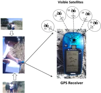
Figure 1. Data collection using a Global Position System (GPS)
The geographic and location data were collected using a handheld Global Positioning System (GPS) receiver as shown in Figure 1. A GPS was used to collect the control points (reference points) to be used for georeferencing and, was also used to pick the locations of the pests. GPS takes the X and Y coordinates of the area of interest. The Ground Control Points (GCP) were collected in order to be used for geo-referencing. The field corners and boundaries for individual farm data were also collected to map the farms and produce a land-use map.
The GPS is made up of 24 fully operationally orbing satellites as shown in Figure 2.
Figure 2. Satellites and GPS receiver link
doi: 10.17700/jai.2019.1.1.497 16 Basuti Bolo, Dimane Mpoeleng: Mapping of Crop Birds Pest using GPS and GIS.
The measurement of Global Positioning System (GPS) is based on three dimensional (3D) trilateration from satellites. It is a mathematical method of determining the relative positions using the geometry of triangles from satellites. The GPS receiver then can pinpoint the location (PP) once it has information of more than three satellites using a process called trilateration as shown in Figure 3.
Figure 3. Trilateration process
The more the satellites appear the more position accuracy received by a GPS receiver. GPS satellites have atomic clocks on board to keep accurate time. Each satellite transmits information about its position and time at a regular interval in signals traveling at the speed of light.
4.2 Data capture and analysis
All the information obtained from fieldwork and other sources were captured by digitizing. The data were obtained to produce maps that show the distribution of quelea birds. Quelea database was developed and produced into tables to show the information about every site using the Microsoft Excel spreadsheet. The quelea birds' activities data was used to produce a map of breeding colonies sites. Buffer zones were created on quelea breeding sites to show areas of the damage. Buffer creates new output coverage by generating buffer zones around input coverage features. A buffer zone of 10km was created to show the distance of crop damage within the breeding colonies sites. The data was analyzed using GIS Overlay analysis tools. An Overlay is a spatial operation tool that overlays two or more polygons, points or lines to create a new output map. The maps were overlaid to produce a single map showing the distribution of the birds and their habitats.
5. Results
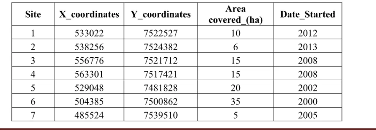
Twelve colonies were mapped and found to be all the breeding colonies as shown. The population of quelea within a colony ranges from thousands to millions of birds. The area covered by the birds ranged between three hectares to thirty-five (35) hectares per colony as shown in Table 1.
Table 1. Quelea breeding Colonies
Site X_coordinates Y_coordinates covered_(ha) Area Date_Started
1 533022 7522527 10 2012
2 538256 7524382 6 2013
3 556776 7521712 15 2008
4 563301 7517421 15 2008
5 529048 7481828 20 2002
6 504385 7500862 35 2000
doi: 10.17700/jai.2019.1.1.497 17 Basuti Bolo, Dimane Mpoeleng: Mapping of Crop Birds Pest using GPS and GIS.
Table 1 shows the information about the 12 breeding sites of quelea birds pest. The pest birds were found in the study area. The X and Y coordinates are the coordinates of the breeding sites that were taken at the center of the breeding area in order to be accurate with the position. The date started to represent the year the birds started to breed and live permanently on the site. From the table, it shows that the birds were found in the area since 2002. The birds covered the area of about three hectares to 35 hectares in one site. This information can be used for control purposes and planning.
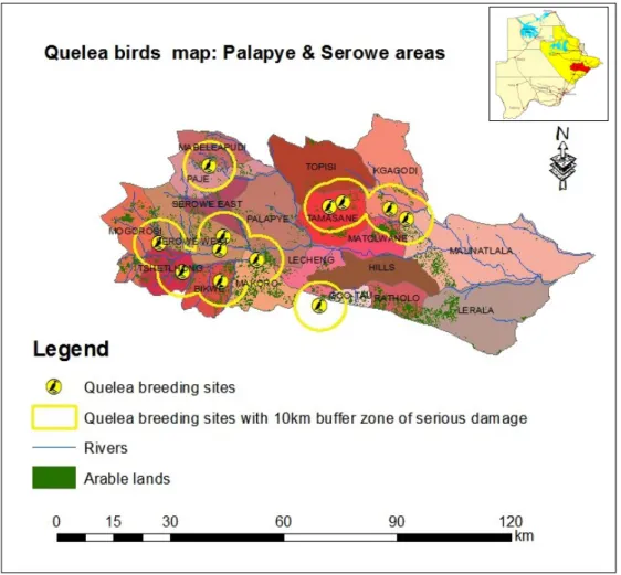
A map was produced to show the spatial distribution of the quelea birds' pest as shown in Figure 4. From the map, the crop birds pests are found in the areas where there are some crop fields and near the river streams. Because the birds feed on the cereal crops they are expected to be found near farming areas. From the literature, the birds do most damage within 10km of the breeding sites and in this study, the birds' colonies were also causing damage within 10km of the breeding sites, and as shown on the map the birds are found near arable fields. Buffered zones (yellow circles) represent 10km distance away from the breeding sites where the X and Y coordinates were collected.
Figure 4. Distribution of quelea birds
The fields that are likely to be affected by the birds most are the ones within the 10 km buffer zones. The 10km buffer is not limited, the birds can cause damage up to a maximum of 30 km away.
8 491196 7510507 10 2012
9 489735 7505200 3 2010
10 490214 7492008 5 2010
11 475041 7495881 12 2012
doi: 10.17700/jai.2019.1.1.497 18 Basuti Bolo, Dimane Mpoeleng: Mapping of Crop Birds Pest using GPS and GIS.
Displaying the spatial distribution of the birds and possible areas of damage help in the decision making and measures on how to control, where and when.
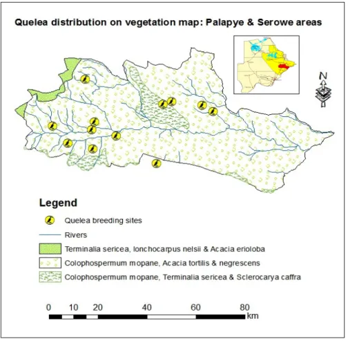
5.1 Distribution of quelea and vegetation
The land cover is important for showing the distribution of vegetation and quelea habitats. The distribution of the preferred grasses and vegetation within the quelea range provides information on those areas where quelea may establish their breeding colonies. Quelea is found in two classes of vegetation with Acacia species as shown in Figure 5. The quelea breeding sites are found where there are shrubs. The vegetation species is mostly acacia species. The acacia trees are the shrubs with heights of approximately up to 3m. These trees are preferred by quelea birds for building their nests because the trees have small thorny branches that are close together and have spaces that can be used by the birds to build a nest that can not be destroyed easily by winds and heavy storms.
Figure 5. Distribution of quelea birds and their habitats
The vegetation found was mostly acacia species used by quelea birds for nesting. From the map (Figure 5) the Acacia tortilis and the acacia negrescens are the main species preferred by the birds for nesting. Quelea was found near the water sources, mainly the rivers as shown on the map in Figure 5. Quelea drinks water in the morning and afternoon. Therefore they are expected to be found near water sources. Arable lands illustrate the quelea's main source of food and so main habitats as well. As expected, quelea was also found close to arable lands.
doi: 10.17700/jai.2019.1.1.497 19 Basuti Bolo, Dimane Mpoeleng: Mapping of Crop Birds Pest using GPS and GIS.
presented to produce the result maps. This research has proved that GPS and GIS can be used to manage quelea birds.
6. Discussion and Conclusion
The study has demonstrated the utility of GPS, GIS and field survey techniques in providing information for mapping and assessing quelea bird pests habitats. A field survey was found to be a useful method for surveying the areas of birds pest and to assess and locate their breeding sites physically. Field survey is also useful in assessing the pest habitats such as the vegetation cover and other the environment. A field survey was found to be useful in ground truthing. The birds' pest habitats were identified during the field survey. When mapping pest birds a field survey is important for ground truthing and it improves the accuracy of the locations.
The GPS technology has proved to be useful for positioning the locations of a point coverage (breeding sites). The quelea data that was collected by a GPS had been converted and transformed from X and Y coordinates to a digital map showing geospatial information about the quelea birds' pest habits and spatial distribution. With GPS, maps showing point coverage can be produced and be useful for decision-making purposes.
GIS has shown to be a capable tool to map and analyse the distribution of quelea birds pest. With GIS, maps can be produced faster, as for this study. The data can be modeled or updated much easier. Reports can be produced for users as well as decision making. GIS techniques are more efficient than traditional methods in providing information and in modeling the data as well as storage. With GIS overlapping areas can be displayed for easy comparison of two or more features. Comparing this to the traditional method, GIS is capable and a faster tool for pest management.
The methodology used in this study could be adopted by the Plant Protection and Control Organisations for future mapping and monitoring of quelea and other crop pests distribution. The monitoring of quelea ecology and population dynamics should continue and be recorded in order to understand factors affecting quelea migration, movement, breeding and subsequent crop damage everywhere in any country. In the future GPS and GIS can be used to assist in management methods by monitoring annual patterns allowing predictive models to be designed and prepare areas for possible annual control of the crop pest.
References
Aguilar C. H., Lasalita-Zapico F., Namocatcat J., Fortich A., Bojadores R. M. (2014): Farmers’ perceptions about banana insect pests and integrated pest management (IPM) systems in SocSarGen, Mindanao, Philippines IPCBEE 63 pp. 22-27.
Allan R. (1996): The grain-eating birds of Sub-Saharan Africa: Identification, Biology and Management. NRI, University of Greenwich
Allen L. W., Garett K. L., Wimer M. C. (2016): The Los Angeles County Breeding Birds Atlas (LACBBA). USA.
Bolo B. (1999): Mapping the Distribution of quelea birds and damage assessment in the north east District of Botswana. Honours Degree Dessertation, University of Greenwich, UK
Davis B. (1996): GIS: A Visual Approach. Onward Press. USA Department of the Environment. Handling Geographic Information. Report of the Committe of Enquiry chaired by Lord Chorley. HMSO, London. Deleon L., Brewer M. J., Isaac L., Esquivel I. L., Halcomb J. (2017): Use of a geographic information system to produce pest monitoring maps for south Texas cotton and sorghum land managers,
http://dx.doi.org/10.1016/j.cropro.2017.07.016.
Dminić I., Kozina A., Bažok R., Barčić J. I. (2010): Geographic information systems (GIS) and entomological research: A review. Journal of Food, Agriculture & Environment 8(2), pp. 1193-1198.
doi: 10.17700/jai.2019.1.1.497 20 Basuti Bolo, Dimane Mpoeleng: Mapping of Crop Birds Pest using GPS and GIS.
Idris N. H., Said M. N., Fauzi M. F., Yusri N. A. M., Ishak M. H. I. (2015): A Low Cost Mobile Geospatial Solution to Manage Field Survey Data Collection of Plant Pests and Diseases. Presented in IEEE Workshop on Geoscience and Remote Sensing, Kuala Lumpur Malaysia: IWGRS 2015.
Kelly M., Guo Q. (2017): Integrated Agricultural Pest Management Through Remote Sensing and Spatial Analyses. https://doi.org/10.1007/978-1-4020-6061-8_7
Markula A., Jones M. H., Csurhes S.C. (2016): Red-billed quelea. First published 2009, Updated 2016.
https://www.daf.qld.gov.au/__data/assets/pdf_file/0011/57845/IPA-Red-Billed-Quelea-Risk-Assessment.pdf
Metzingen F. W. (1993): A Guide to Migrant Pest Management in Africa. UNDP/FAO, Rome, Italy. Natikar P. K., Balikai R.A., Anusha C.H. (2016): Pest Management Strategies in Precision Farming. J. Exp. Zool. India 19(1), pp. 1-8.
www.connectjournals.com/jez ISSN 0972-0030
Pratap B. S., Sharma O. P., Kumar S. (2000): Economics of Integrated Pest Management: Evidences and Issues. Indian Journal of Agricultural Economics. 55(4): pp. 644-659.
Rani D. S., Venkatesh M. N., Sri N. S., Kumar K. A. (2018): Remote Sensing as Pest Forecasting Model in Agriculture. International Journal of Current Microbiology and Applied Sciences ISSN: 2319-7706, 7(03)
https://doi.org/10.20546/ijcmas.2018.703.310
Rao A. S., House R. I., Gupta C. S. (1989): Review of Sorghum, Pearl Millet, and Finger Millet improvement in SADCC countries. SACCAR
Sabtu N. M., Idris N.H., Ishak M. H. I. (2018): The role of geospatial in plant pests and diseases: an overview IOP Conference Series: Earth and Environmental Science. IOP Conf. Ser.: Earth Environ. Sci. 169 012013
https://doi.org/10.1088/1755-1315/169/1/012013
Sciarretta A., Trematerra P. (2014): Geostatistical Tools for the Study of Insect Spatial Distribution: Practical Implications in the Integrated Management of Orchard and Vineyard Pests’. Plant Protect. Sci. 50(2) pp. 97-110
https://doi.org/10.17221/40/2013-PPS
Trimble (2016): Mapping & GIS: handheld computers with GNSS