Chatham County Bicycle Plan
Prepared for: Chatham County Town of Siler City Town of Pittsboro
Acknowledgements
The following individuals and organizations were instrumental in completion of the plan: Chatham County Board of County Commissioners
Brian Bock, Chair Walter Petty
Allen Michel "Mike" Cross Sally Kost
Pam Stewart
Chatham County Transportation Advisory Board Delonda Alexander
Mary Bastin David Bordsen Philip Bors
Faythe Canson Clark Dale Chodorow Robin Emerson Claire Kane
Chatham County Parks and Recreation Advisory Board Andrew Allden Ernest Clemons Al Craven Joe Fraser Don Lein Elizabeth Reid Jennifer Sipe Willie Snipes George Pauly Ray Sugg Active Chatham Anna Vila Mola Annie Martinie Bill Bussey Bruce Murray Carla Strickland Don Lein Evie Houtz Joseph Ellen Kelly Evenson Kim Sevy Lindsay Hickling Marissa Jelks Pam Rafetto Rocco Richard Scott Evenson Chatham County
Melissa Guilbeau, Transportation Planner Ben Howell, Planner
Tracy Burnett, Parks & Recreation Director Megan Bolejack, Health Promotion Coordinator
Siler City
Joel Brower, Town Manager Jack Meadows, Planning Director
Donald Dones, Director of Parks & Recreation
Pittsboro
Paul Horne, Parks Planner
Other Government
Paul Black, former TARPO Coordinator
Dale McKeel, Durham Bike and Pedestrian Coordinator Karen Lincoln, Orange County Transportation Planner
Chatham County Residents and Out of County Bicyclists
Nearly 500 surveys regarding bicycling in Chatham County were completed. In addition, many survey respondents reviewed the plan and made helpful suggestions.
Carolina Tarwheels Bicycle Club
University of North Carolina- Chapel Hill Department of City and Regional Planning
For pictures:
Table of Contents
Executive Summary ... 5
Chapter 1: Introduction ... 7
1.1 Background, Purpose and Scope ... 7
1.2 A Vision for Bicycling in Chatham County ... 8
1.3 Goals and Objectives ... 8
1.4 Methodology ... 9
1.5 Plan Elements ... 10
Chapter 2: Existing Conditions ... 13
2.1 Community Overview ... 13
2.2 Existing Bicycle Facilities and Conditions ... 15
2.3 Bike Crash Statistics ... 24
2.4 Existing Plans and Policies ... 24
2.5 Survey Results ... 30
Chapter 3: Facility Design Standards ... 33
3.1 National and State Guidelines ... 33
3.2 Bike Facility Types ... 33
3.3 Bicycle Friendly Intersections ... 37
3.3.1 Intersection with Turn Lanes ... 37
3.3.2 Signalized Intersections ... 37
3.3.3 Roundabouts ... 38
3.4 Signage ... 38
3.5 Bicycle Parking ... 39
3.6 Drainage Grates ... 39
4.1 The Bicycle Network ... 41
4.2 Short Term Projects ... 47
4.3 Long Term Projects ... 49
4.4 Network Prioritization ... 51
4.5 Miscellaneous Improvements ... 52
Chapter 5: Recommended Programs and Policies ... 54
5.1 Bicycle Program Recommendations ... 54
5.2 Education ... 54
5.3 Encouragement ... 57
5.5 Policy Recommendations ... 61
Chapter 6: Implementation ... 65
6.1 Implementation Steps ... 65
6.2 Establishing a Bike and Pedestrian Subcommittee ... 66
6.3 Local and Regional Planning Efforts ... 66
6.4 Becoming a Bike Friendly Community ... 67
6.5 Evaluation and Monitoring ... 67
6.6 Funding Sources ... 68
6.7 Implementation Strategy ... 71
Appendix A: Bicycle Survey Questions & Answers... 74
Appendix B: Short Term Network Project Recommendations ... 85
Appendix C: Long Term Network Project Recommendations ... 89
Appendix D: Image Sources ... 94
Figures and Tables
Figure 1.1: Plan Methodology ... 9
Figure 2.1: Population Density in Chatham County (2000) ... 13
Figure 2.3: Old Bynum Bridge ... 16
Table 2.1: Road Bicycling Issues Indicated in Survey ... 17
Table 2.2: Intersection Issues from Survey ... 17
Figure 2.4: Existing Bike Routes, Roads and Attractions – County Wide ... 18
Figure 2.5: Existing Bike Routes, Roads and Attractions -- Pittsboro ... 19
Figure 2.5: Existing Bike Routes, Roads and Attractions – Siler City ... 20
Figure 2.6: Survey Findings – Route and Intersection Conditions - Countywide ... 21
Figure 2.7: Survey Findings – Route and Intersection Conditions - Pittsboro ... 22
Figure 2.8: Survey Findings – Route and Intersection Conditions – Siler City ... 23
Table 2.3: Bike Crashes in County and Municipalities ... 24
Table 2.4: DCHC Long Range Transportation Plan Bicycle Projects ... 29
Table 2.5: Bicycle Survey Respondent Location and Experience Level ... 30
Table 2.6: Reasons Preventing Survey Respondents from Riding More, by Experience Level ... 31
Table 3.1: Bike Facility Types and Characteristics ... 34
Figure 3.1: Wide Paved Shoulder ... 34
Figure 3.2: Wide Outside Lane ... 35
Figure 3.3: Shared Lane Marking in Chapel Hill ... 35
Figure 3.4 Winston Salem Bike Lane ... 36
Table 3.2 Bike Lane Widths for Roadway Type ... 36
Figure 3.5: Recommended Shared Use Path Dimensions ... 37
Figure 3.6: Intersection with Turn Lanes ... 37
Figure 3.8: Bicycle Warning Signs ... 38
Figure 3.9: U Style Bike Rack ... 39
Figure 3.10: Bike Friendly Drainage Grate ... 39
Table 4.1: Bicycle Network Mileage ... 41
Figure 4.1: Short Term Bicycle Network ... 43
Figure 4.2: Long Term Bicycle Network ... 45
Figure 4.3: Share the Road Signage ... 47
Figure 4.4: US 64 – Adjacent Shared Use Path Concept ... 51
Figure 5.1: Example of NCDOT Handout ... 54
Table 5.1: Education Program Recommendations ... 55
Figure 5.2: NCDOT Poster Example ... 56
Figure 5.3 Bicycle Rodeo in Elizabeth City ... 56
Table 5.2: Encouragement Program Recommendations ... 57
Figure 5.4 Asheville Strive Not to Drive Poster ... 58
Figure 5.5 Randolph County Bicycle Map ... 59
Executive Summary
This Bicycle Plan is the first bicycle plan for Chatham County, NC. It’s goals include making bicycling a viable transportation option for residents and provide a high quality recreation amenity for residents and visitors alike. To meet this overarching goal, the plan activities included an evaluation of Existing Conditions (Chapter 2) and research of state and national Design Standards (Chapter 3) in order to create a Recommended Bicycle Network (Chapter 4). The plan also uses research of best practices and investigation of other plans to Recommend Programs (education, encouragement,
and enforcement) and Policies (Chapter 5) that lead to a better bicycling climate. Finally it discusses the Implementation (Chapter 6) of the plan recommendations.
Existing Conditions
Chatham County has over 130 miles of signed state, county and local on-road bicycle routes. None of these routes have extra accommodation for bicycle nor do bicycle lanes exist in the county. The county’s only off-road facility, the American Tobacco Trail, a shared use path connecting Durham to Cary, runs 4.1 miles through the north eastern corner of the County. A survey of nearly 500 residents and non-resident bicyclists found that more would bike (and more often) if the county had more on and off road facilities and safer driving by bicyclists, among other factors. Chapter 2 discusses these conditions in more detail.
Design Standards
State and national design standards regarding on and off road facilities are discussed in Chapter 3; guidelines include those for bicycle lanes, wide outside lanes, shared use paths, intersection improvements, parking standards and other miscellaneous improvements. These guidelines were used to help determine the bike facilities for the Recommended Bicycle Network.
Recommended Bicycle Network
The plan recommends a final long term bicycle network consisting of over 400 miles of on and off road facilities. These facilities include shared roads, signed routes, bicycle lanes and off-road shared use paths. The network also includes intersection improvements. In all, 26 short term (less than 10 year) and
Photo by Wayne Clark
Type Existing Mileage Future Mileage Completed Mileage Short Term Long Term
Shared Roads 0 87.1 50.7 137.8
Signed Routes
on Shared Roads 131.3 0 0 131.3
Bicycle Lane -
Construction 0 0 33.9 33.9
Bicycle Lanes-
Restripe 0 0.4 3.5 3.9
Total On- Street Facilities 307
Shared Use
Paths 4.1 2.0 105 111
Total Facilities 418 miles
28 long term projects are necessary to complete this bicycle network. Chapter 4 provides more detail regarding the network, projects and their costs.
Programs and Policy Recommendations
Providing a quality environment for bicycling also requires education, encouragement and enforcement programs and bike-friendly policies, described in Chapter 5. Education programs include distribution of safety materials, bicycle rodeos, and training to law enforcement regarding bicycle traffic laws. Encouragement programs seek to persuade non riders to bicycle and riders to bicycle more; these programs could include awareness days and events and bicycle map enhancements. Targeting roads traveled heavily by bicycles for stricter traffic enforcement (speeding, passing too closely to bicycles) is another way to improve safety for cyclists. Many local examples point to the effectiveness of these programs.
Implementation
Chapter 1: Introduction
This chapter gives a Background of bicycling initiatives in the county, includes the Purpose and Scope of the plan, describes the overarching VisionStatement for Chatham County as related to bicycling, sets Goals and Objectives for the plan, describes the Methodology that created the plan, and finally describes the Plan Elements.
1.1
Background, Purpose and Scope
This is the first official Bicycle Plan for Chatham County, though there have been other initiatives aimed at improving the county’s bicycling environment. In the late 1990s, NCDOT’s Division of Bicycle and Pedestrian Transportation, along with the Pittsboro-Siler City Convention & Visitor’s Bureau, worked with local bicycle advocates and governments to create the Chatham County Bicycle Map showing a bicycle network utilizing existing roads. This map is set for updates and reprinting in 2011. More recently, the County’s Public Health Department, in its Chatham County 2010 Community Health Assessment, found that one of the four major health concerns affecting Chatham residents was physical inactivity, noting that the county lacks many safe areas to bike or walk.
The purpose of this Plan is to identify facility, program and policy recommendations to improve bicycling conditions in Chatham County. The Plan accomplishes this by establishing a vision and goals for bicycling in the county, assessing existing conditions and initiatives, identifying the needs of the users and recommending policies, projects and programs to achieve the vision.
The Plan will serve as the basis for the Bicycle Element of the county’s upcoming Comprehensive Transportation Plan, which is set to be completed in late 2012. It will also help the county secure funding for future bicycle facilities, since projects identified in an adopted Bicycle Plan score higher in NCDOT’s Division of Bicycle and Pedestrian Transportation ranking system.
The Plan covers the entire county, including the Town of Siler City, Town of Pittsboro, Town of Goldston and the portion of the Town of Cary located in Chatham County. It addresses both on and off road projects, policies and programs for both recreational and non-recreational riding.
Chapter Contents
1.1 Background, Purpose and Scope
1.2
A Vision for Bicycling in Chatham County
A vision helps focus a project to the final outcome and define its goals and objectives. The Vision expresses the desired outcome of the Plan, rather than the current conditions.The Vision was drafted from comments from the online survey of local residents and riders, existing County plans and reports and input from County staff, and was refined through discussions with select Chatham Transportation Advisory Board (TAB) members and other bicycle supporters. The Vision also draws from the TAB’s Strategic Plan, which explicitly states that the TAB values a transportation system that supports social/equity, health, economics, education, environment, connectivity and a balance of travel modes.
1.3
Goals and Objectives
These goals and objectives were created through conversations with county staff and public input.
Goal 1: Provide a safe bicycling transportation network for all experience levels
Objective 1.1: Assess and make recommendations on existing bicycle network deficiencies.
Objective 1.2: Assess and make recommendations on creating new bicycle facilities to connect county destinations.
Objective 1.3: Ensure adequate parking for bicycles at public and commercial facilities throughout the county.
Goal 2: Encourage more residents to ride bicycles
Objective 2.1: Develop encouragement programs to increase bicycling rates.
The Vision
Goal 3: Improve bicycle safety through education and enforcement Objective 3.1: Develop and implement bicycle safety education programs for motorists, bicyclists, students and the public. Goal 4: Make Chatham County a preferred bicycle tourism destination
Objective 3.1: Assess and update county Bicycle Map to help educate both residents and tourists.
Objective 3.2: Encourage the opening of a bicycle shop in the county.
Objective 3.3: Promote bicycling through local businesses, the Chamber of Commerce, and other Chatham organizations. The goals and objectives were developed through input from the public, county and municipal staff.
1.4
Methodology
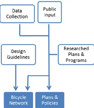
To develop a bicycle plan for Chatham County, activities included data collection, visioning and goal setting, analysis and Bike Network and program recommendations.
Data collection activities included:
o Windshield surveys on select roads,
o Google Street View™ review of other roads, o Geographic information systems (GIS)
analysis,
o Discussion with county citizen’s advisory boards, Pittsboro and Siler City government representatives and other county staff. Public input included a survey of bicycle interests and
needs with more than 400 residents and non-resident Chatham bicyclists, more focused review of the plan
from Chatham residents subset of these survey respondents, and a thorough review of existing plans and policies, many which included public input.
These activities also provided input to set the vision, goals and objectives, and provided a comprehensive depiction of the existing bicycling network and facilities in the county (Chapter 2).
Then staff created a recommended Bicycle Network that consists of on and off-road facilities by:
Analyzing the existing bicycle conditions (as outlined in Chapter 2).
Researching bicycle facility types as well as state, federal and other guidelines for future bicycle facilities in the county (Chapter 3).
Mapping and analyzing destinations and bicycle attractors such as parks and schools. Vehicle counts provided by NCDOT and observations helped to determine the recommended facility type.
Using off-road bicycle routes from the Chatham Parks and Recreation Master Plan (2009-2029) and from the US 64 Corridor Plan.
Next, the plan recommended successful programs that used education, encouragement and enforcement to improve bicycling as well as policies that help improve the conditions for bicycling in the county. These were taken from national examples, and include resources for additional information.
1.5
Plan Elements
The Plan includes the following chapters: Chapter 2:Existing Conditions
This chapter describes the conditions for bicycling in the county. It gives an overview of the county’s transportation system, existing bicycle facilities and conditions, crash statistics, reviews plans and policies related to bicycling and provides results of a survey regarding bicycling in the county.
Chapter 3:Facility Standards and Guidelines
This chapter includes national and state guidelines regarding standards for bicycle facilities, introduces bike facility types and appropriate usage. Standards discuss include guidelines for on and off street facilities, intersections, signage, and parking.
Chapter 4:Recommended Bicycle Network
miscellaneous improvements that help improve bicycling in the county.
Chapter 5:Program and Policy Recommendations
This chapter provides potential programs and policy changes to help support bicycling. This includes encouragement, education and enforcement programs and policies at county and municipal levels. Chapter 6: Implementation Strategy
This chapter describes how Chatham County and its municipalities can make the Recommended Bicycle Network a reality. It includes implementation steps, describes evaluation and monitoring options as well as potential funding sources for the plan.
There are also five appendices that complement these chapters: Appendix A: Bicycle Survey Questions & Answers
This appendix provides the Bicycling in Chatham County Survey, which provided key information to complete this plan. It includes the detailed results of each question for the Bicycling in Chatham County Survey—highlights of this survey are included in Chapter 2. Appendix B: Short Term Network Project Recommendations Describes the specific projects to complete the short term network Appendix C:Long Term Network Project Recommendations Describes the specific projects to complete the long term network Appendix D: Image Sources
This details the source of each of the images within the plan. Appendix E:Literature Review
Chapter 2: Existing Conditions
Existing conditions were evaluated in order to understand the barriers, opportunities for improvement and desires of current users and residents for a bicycle transportation system. This chapter’s evaluation includes:
A Community Overview including socioeconomic and geographic characteristics and a description of the existing transportation system.
A description of the Existing Bicycle Facilities and Conditions. Bike Crash Statistics since 1997.
A review of Existing Plans, Policies and Programs that contribute to the bicycling environment in Chatham County. A review of Survey Results from residents and existing riders on
biking attitudes, perceptions and route conditions.
2.1
Community Overview
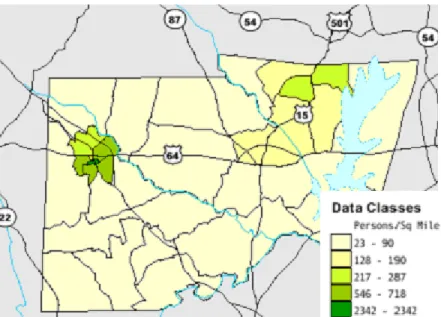
Chatham is a large, mostly rural county characterized by rolling hills, densely wooded areas and farmland. It is located at the geographic center of the State of North Carolina and between two large metropolitan regions – the Raleigh-Durham “Triangle” and the Greensboro “Triad”. Jordan Lake, a regional
recreation attraction, is located in the eastern portion of the county. The county is best described by geographic area – east and west. The eastern portion of the county, including the Town of Pittsboro and a portion of the Town of Cary, includes a number of
suburban housing developments with a population density significantly higher than the rural sections of the county. The western portion of the county is characterized by working lands, with the exception of the Town of Siler City, which boasts the highest population densities in the county, as shown in Figure 2.1. While higher densities can equate to a better bicycling climate, with closer distances between destinations, increased traffic in these areas make bicycle and vehicular conflicts
Chapter Contents
2.1 Community Overview 2.2 Existing Bicycle Facilities and
Conditions
2.3 Bike Crash Statistics 2.4 Existing Plans and Policies 2.5 Survey Results
much more likely. For this reason, facilities and education for safe bicycling are even more important in Siler City.
Chatham County’s population grew by 31.9% over the past 10 years, to 63,505 according to the 2010 Census1, largely due to growth pressures from the adjacent Triangle region. The State has estimated the population to continue to increase to over 75,000 in 2020 and 86,000 in 20302. According to the 2010 Census, 21% of the population lives in the incorporated towns of Siler City (7,887), Pittsboro (3,743), Goldston (268) and Cary (1,422—though most of its population is in Wake County). The county’s population has increasingly become Hispanic (12.9% of residents), mostly in the western section of the county. The population is aging: its estimated median age as of 2009 was 42, up from 38.7 in 2007 and above North Carolina’s median. The county is also characterized by income disparities; while its median income ranks 8th in the state, over 10% of its population live below the poverty line lower than the state average of nearly 15%. As car ownership and operation costs increase, and population growth continues to occur, providing and accommodating alternative transportation options, like the bicycle, will be key to maintaining mobility.
As of 2000, more than half of Chatham residents were employed out of the county—long distances which make it difficult for many to use bicycling as a commute mode3. A third of the local economy is based on agriculture and agribusiness4. Tourism – much of it ecotourism and outdoor recreation – is becoming more and more important, with a
1 Chatham County North Carolina. (2011). Population and Income Information.
Available: http://www.chathamnc.org/Index.aspx?page=26. Retrieved on March 21, 2011.
2
Office of State Budget and Management. (September 2010) County/State Population Projections. Available:
http://www.osbm.state.nc.us/ncosbm/facts_and_figures/socioeconomic_data/ population_estimates/county_projections.shtm. Retrieved on March 1, 2011.
3
Chatham County North Carolina. (2011). Chatham County’s Economy. Available: http://www.chathamnc.org/Index.aspx?page=27. Retrieved on March 21, 2011.
4
Chatham County North Carolina. (2011). Agriculture in Chatham County.
double-digit growth in the sector over the past three years. Bicycling could potentially be an important part of this tourism in the county. According to the US Census’ American Community Survey (2005-2009), 76.2% of Chatham County commuted to work alone by automobile5. Less than one percent of commuters used bicyclists as their primary method of getting to work. Many recreational bicyclists in the county actually ride from other counties, notably Wake and Orange Counties. Four major US Highways criss-cross Chatham County. US 15-501 enters from Chapel Hill and traverses the county’s eastern portion from north to south. US 421 travels from Greensboro from the northwest corner of the county by Siler City and through Goldston in the southern quarter. US 64 crosses the county from west to east, connecting the two major municipalities, Siler City and Pittsboro, to Asheboro westward and Raleigh eastward. US 1 crosses the southeastern corner of the county around Moncure. These roads are mostly four lane highways, sometimes with controlled access but typically with at-grade connections to local roads.
Other roads are typically two lane rural roads, sometimes windy and with steep slopes. These roads may have turning lanes and traffic signals. Bikes have been observed using the sidewalks in Pittsboro, Siler City and some of the newest subdivisions in the county.
2.2
Existing Bicycle Facilities and Conditions
Chatham County has three designated state bicycle routes, two “bicycle highways” and three suggested, unmarked “connector” routes. Portions of the US 1 Bicycle Highway, North Carolina Mountains to Sea Trail and the Piedmont spur of this trail also briefly enter the county. The existing bicycle network is shown in Figures 2.3, 2.4 and 2.5 (pages 18-20). This map also shows potential attractors such as recreation areas and schools.
5
The American Tobacco Trail (ATT) is the only official off-road bicycle facility in the county. It is a 4.68 mile shared use path in the northeastern corner of the county, part of a larger 22 mile rails-to-trails project that connects Cary and Apex to the southeast with Durham to the north. It was constructed in an abandoned corridor of the Norfolk Southern Railroad and opened in May 20106. The Chatham portion of the ATT is surfaced with ten feet of asphalt and six feet of granite screenings for horses and joggers/walkers. The asphalt is in good condition and includes a very slight grade, with no steep slopes or sharp curves. Based on weekend observations and user comments, it is utilized by a large range of age groups and experience levels. Over 50% of the survey respondents stated they had ridden the trail, with 15% more planning to ride in the future.
The Old Bynum Bridge also provides an off-road, albeit short, facility. Crossing the Haw River by Bynum, the bridge is closed to vehicular traffic and is part of State Bike Route 3. Seventeen feet wide, there are some cracks and vegetation on the bridge, but it is marked (by signage and pavement markings) as well as physically blocked from vehicular traffic.
Bike parking facilities are rare in Chatham County. Of the recreational facilities in the county, only Mary Haws Park in Pittsboro has a bike rack. There is also a bike rack at the new Chatham Public Library at the Central Carolina Community College (CCCC) in Pittsboro.
The existing system accommodates experienced road cyclists but doesn’t accommodate casual, inexperienced or commuter cyclists outside of residential subdivisions or the American Tobacco Trail. Bike routes typically follow rural two-lane roads, which have no separate facilities for bicycling and often have high speeds and poor sight distances due to curves and hills. In most cases, these are less travelled local roads with signs designating the route so bicyclists can keep track of their location and “Share the Road” signs that increase motorists’
6
Triangle Trails Conservancy. (Dec 6 2010). The American Tobacco Trail. Available: http://www.triangletrails.org/ATT.HTM. Retrieved on January 25, 2011.
Figure 2.2: American Tobacco Trail
awareness for bicyclists. In some cases, these routes move through more congested areas, more often in the northeast quadrant in the county. When routes change roads or cross intersections, signage is used to provide riders direction. Other than these signs, there is no added bicycling infrastructure, such as bike-activated traffic signals, striped bike lanes, or bike markings painted on streets. On the major four lane highways of US 64 and US 15-501, outside shoulders exist without rumble strips, but these are not always uniform width or clear of debris. Even with these facilities, the speed (55mph speed limit and freeway design) gives the bicyclist the perception of isolation and vulnerability.
While time and resource constraints limit the ability to inspect every road in the county, user surveys and other sources shed light on current deficiencies in the road biking network. Survey results provided by existing riders and drivers
pinpointed routes and intersections where conditions are suboptimal for bikes and/or conflicts between vehicles and bicycles exist. Figures 2.7-2.9 (on pages 21-23) show
these survey results as located in Chatham County
Table 2.1 includes common issues with on-road bicycling as well as some examples of road segments
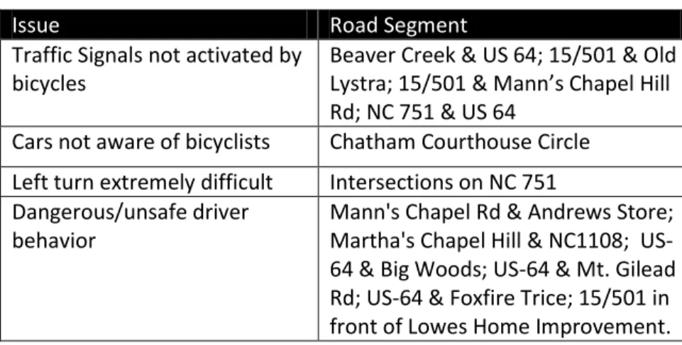
exhibiting that issue. Keep in mind that there are no marked bicycle lanes on any roads in the county and only sections of the major four lane highways (i.e. US 15/501 north of Pittsboro and US 64) have wide shoulders that bikes can utilize. Survey respondents also indicated specific intersections that are
dangerous or awkward for bikes. The intersections and their issues are described in Table 2.2. .
Table 2.1: Road Bicycling Issues Indicated in Survey
Issue Road Segment
Vehicles not obeying traffic laws (passing bicycles too closely, speeding)
O’Kelly Chapel Rd, Mt. Carmel Rd
No shoulder Most two-lane rural roads
Heavy vehicular traffic NC 751, US 15/501 Poor pavement quality (uneven or poor
surface)
Andrews Chapel Rd Between Mann’s Chapel and 15/501, Rives Chapel Rd
Poor quality or debris in shoulder US 15/501 north of US 64 to Orange County Line; US-64 High number of logging trucks Moncure Pittsboro Rd Road is curvy and hilly; poor sight lines Hamlet’s Chapel
Table 2.2: Intersection Issues from Survey
Issue Road Segment
Traffic Signals not activated by bicycles
Beaver Creek & US 64; 15/501 & Old Lystra; 15/501 & Mann’s Chapel Hill Rd; NC 751 & US 64
Cars not aware of bicyclists Chatham Courthouse Circle Left turn extremely difficult Intersections on NC 751 Dangerous/unsafe driver
behavior
2.3
Bike Crash Statistics
It’s important to analyze the historical incidence of bike crashes in the county. This can be used as a
baseline for
improvement as safety infrastructure and initiatives take place in the future. Between 1997 and 2008, there have been 65 reported bike crashes in the county on the whole, 13 of which were in Siler City and two in Pittsboro7. Minorities
are disproportionately represented, involved in nearly half of the bike crashes in the county and over 80% in Siler City. Certain age groups also have higher crash rates, notably children under 15 (32%) and those aged between 30 and 39 (26%). Many of these crashes (nearly three per year) have been severe. These data include only crashes in which a police report was filed, suggesting an undercount of actual bicycle crashes. Table 2.3 summarizes the number of bike crashes by year.
2.4
Existing Plans and Policies
The Plan must react to and address existing plans, policies and programs that pertain to bicycling in Chatham County. This review is divided into three sections: Local, Regional, and State. Local refers to any Chatham County, Siler City or Pittsboro plans, programs or policies relating to bicycling. Regional refers to any plans, programs or policies
7
UNC Highway Safety Research Center. (2011). North Carolina Pedestrian and Bicycle Crash Data Tool. Available: http://www.pedbikeinfo.org/pbcat/
Retrieved on February 25, 2011.
Table 2.3: Bike Crashes in County and Municipalities
Year County Siler
City Pittsboro Total
1997 4 1 0 5
1998 3 1 0 4
1999 4 2 0 6
2000 3 1 0 4
2001 6 1 2 9
2002 4 0 0 4
2003 5 2 0 7
2004 4 2 0 6
2005 2 0 0 2
2006 4 2 0 6
2007 4 0 0 4
2008 7 1 0 8
promulgated in the region, generally by the Triangle Area Rural Planning Organization (TARPO) and the Durham-Chapel Hill-Carrboro Metropolitan Planning Organization (DCHC MPO). State refers to any NCDOT programs or laws that pertain to bicycling.
2.4.1
Local Plans and Policies
Pittsboro Pedestrian Transportation Plan (2009)
Pittsboro adopted a Pedestrian Transportation Plan in 2009. This plan provides an assessment of existing conditions and provides recommendations on both on-street and off-street pedestrian improvements.
The plan also includes a recommended greenway alignment that runs near downtown Pittsboro along railroad alignments and on existing sewer easements. The plan includes many potential programs and policy recommendations that can be also used to improve bicycling in the town and other parts of the county.
Transportation Improvement Program
The State Transportation Improvement Program (TIP) contains funding information and schedules for various transportation divisions including: bicycle and pedestrians, as well as motorized transportation. The Siler City 2013-2019 TIP Project list includes a paved trail along Loves Creek from SR 2208 (South Second Avenue) to Pony Farm Road in Siler City. However, other Chatham TIP projects include road widening or creation of new roads. These TIP projects, when appropriate, should accommodate multi-modal travel.
Pittsboro Land Use Plan (2001, currently in review)
Pittsboro’s current Land Use Plan includes vision and goals that promote safe access for multiple modes, including bicycling as well as the creation of greenways. While the draft plan does not include specific recommendations regarding bicycling, it promotes alternative transportation options and includes general background information about the type and usage of bicycling facilities.
Pittsboro Zoning Ordinance (1994, amended 2007)
the types of bicycling facilities recommended in this Plan. Chapter 5 provides recommended amendments.
Pittsboro Subdivision Regulations (1993)
Pittsboro’s subdivision regulations define street classifications but only as related to vehicular traffic, without reference to the multi-modal nature of the streets. Amendments to certain sections can be a way to include “Complete Streets” concepts to strengthen multi-modal component of the streets..
Siler City Ordinances
Siler City Municipal code prohibits bicycling and skateboarding on downtown sidewalks, but permits it outside the Central Business District. The ordinances include sidewalk requirements for varying types of roadways. The ordinance also may require developers to set aside a 10 foot easement for pedestrian facilities if there’s no access from a subdivision to schools, parks, playgrounds or other facilities. Potential amendments to the Siler City Ordinances are recommended in Chapter 5.
Chatham County Compact Communities Ordinance (2004)
The CCCO includes several provisions for bicycling. These ordinances look to create zones where compact style developments, which protect rural farmland and create a more sustainable development pattern, are permitted. Note that these developments are only permitted in a very limited section of the county, bounded by the east by US 15-501, Andrews Store Road on the south, Mann’s Chapel Road on the west and north.
The Section 3 of the CCCO states as its goals:
Goal D: “Allow for compact village-style development ...that is easily walkable and bikeable by residents of all ages;”
Goal H: Establish a grid network of streets that provides multiple connections to different destinations, includes safe places for pedestrians and bicyclists to travel throughout the community, and allows for efficient transit service when and if it becomes available;
Other key points of the ordinance related to bicycling include requiring mixed uses, interconnectivity of streets and creation of narrow streets. In its appendix the ordinances “strongly encourage” bike racks--at least 1 per block--in a potential village center.
County Subdivision Regulations (1980, revised 2008)
The county’s subdivision regulations have some provisions for bicycles. Block lengths are “geared toward creating a street network that accommodates bicycle... scale connections.” Maximum block lengths range from 480’ in 8 unit developments to 660’ in medium density and compact community areas, and 1320’ and other areas. These regulations also discuss easements up to 20’ which may be required for pedestrian or bicycling egress and ingress from schools, neighborhood parks and other public spaces.
Chatham County Zoning Ordinance (2008)
The Zoning ordinances include no requirements for bicycle parking or accommodation. However, it discusses bicycle shops. Although no bicycle shops exist in the county, the county permits them in areas zoned for business (general, neighborhood, community and regional). Amendments that may permit more bicycle accommodation are listed in Chapter 5.
The Chatham Land Conservation and Development Plan (2001)
The Chatham Land Conservation and Development Plan sets out policy objectives that are related to bicycling in the county. One of the objectives deals directly with creating a greenway network that “includes ... biking… trails when appropriate”. Another objective includes a suggestion to incorporate bike trails in new communities, including bike shoulders along roads and in general promoting alternative modes of transportation.
Importantly, one of the 28 plan recommendations includes a review of roadway design, including support for bicycle facilities. The transportation element of the plan reiterates the awareness of the bicycle when revising roadway standards. Lastly, the Schools element recommends locating schools as part of neighborhoods and encouraging new adjacent residential development as ways to provide bicycle access for children. Currently, the plan is in the beginning stages of an update.
Chatham County Parks and Recreation Master Plan 2009-2029, which is currently being considered for adoption, seeks to evaluate existing park and recreation facilities and propose guidelines for implementation of recommendations designed to meet the needs of the population for a span of 20 years. This includes several recommendations related to bicycle transportation. It recommends greenways (as well as a comprehensive Greenway Master Plan) and identifies potential funding mechanisms. The plan also recommends expansion of the bicycle network through bike lanes and provisions of bicycle travel on new roadways, while adding bike racks to all publically owned facilities, including schools. The plan also recommends bike trails at future parks. Public participation in this planning process showed that bike trails were commonly requested by process participants. The plan also highlights the potential of ecotourism, especially with economic impact of attracting bicyclists. The Bicycle Plan will build upon the findings in the County Plan when discussing eco-tourism in Chatham County.
Chatham County Advisory Board and Local Municipality Advisory Boards
Local citizen-led advisory boards can be instrumental in implementing the Bicycle plan. Citizen advisory groups at the County level that have an impact on bicycling are the Transportation Advisory Board (TAB) which oversees Transportation, the Recreation Advisory Boards and the Active Chatham Alliance. Pittsboro also has a Parks & Recreation Advisory Board that advises the town on recreation and parks planning and implementation.
2.4.2
Regional Plans and Policies
This assessment identified important green spaces in the Triangle region, including Chatham County. Although not at a high level of detail, this document can be used to help identify potential greenway corridors in the county.
DCHC MPO Long Range Transportation Plan 2035 (2009)
The DCHC MPO covers the northeastern corner of Chatham County. The Long Range Transportation Plan (LRTP) guides transportation investments in bicycle and pedestrian facilities as well as road and transit projects. As a fiscally constrained document, it only includes potentially funded projects. This plan establishes as a goal a pedestrian and bicycle system that includes safety, access to public transit, recreational opportunities and includes off-road facilities. The plan includes a map that includes 19 miles total of planned bicycle facilities. Details, including length, location and estimated costs (by the DCHC MPO using an estimate of $500,000/mile) are located in Table 2.4.
2.4.3
State Plans and Policies
The North Carolina Department of Transportation (NCDOT) has adopted a number of policies addressing bicycles on state maintained roadways. These policies and guidelines, applied on these roadways when there is new construction or resurfacing projects, impact the bicycling environment in Chatham County and include the following:
Resolution Mainstreaming Bicycling and Walking as part of Transportation System (2000)
The NC Board of Transportation reaffirmed the importance of non-motorized transportation in its highway system. It states that “bicycling and walking accommodations shall be a routine part of the North Carolina Department of Transportation's planning, design, construction, and operations activities.”
NCDOT Bike Policy (1978, updated 1991)
The NCDOT policy details guidelines for planning, design, construction, maintenance, and operations pertaining to bicycle facilities and accommodations. All bicycle improvements undertaken by the NCDOT are based upon this policy. The policy urges strong education of
Table 2.4: DCHC Long Range Transportation Plan Bicycle Projects Facility Location Facility Type Length Total Cost
American Tobacco Trail
Bike Path 5.2 Complete
Mt. Carmel Church Road
Bike Lanes 1.2 $600,000
NC 751 Bike Lanes 3.2 $1,600,000
Farrington Point / Pld Farrington /
Farrington Mill Rd
Bike Lanes 3.66 $1,830,000
O’Kelly Chapel Rd
Bike Lanes 2.9 $1,450,000
US 15-501 South Bike Lanes 3.2 $1,600,000
motorists and school children regarding traffic laws and safety. Lastly, the policy indicates that any state funded buildings, parks and recreational facilities should include bicycle parking facilities.
NC Complete Streets Policy (2009)
This NCDOT policy requires that planners and designers keep in mind multi-modality when planning and constructing any new or improvement of transportation facilities in growth areas of counties and municipalities. The policy is intended to encourage non-vehicular travel without reducing the safety, efficiency or function of the facility while ensuring that all users are considered in the creation and usage of the facility. NCDOT has convened a group of stakeholders that is currently in the process of developing guidelines for the design of complete streets. Administrative Action to Include Local Adopted Greenway Plans in the NCDOT Highway Planning Process and Guidelines (1994)
This action requires highway planners developing highway alignments to take in consideration locally adopted greenway and greenway crossings corridors.
Bridge Policy
This policy controls the design elements of new and reconstructed bridges on the state highway network including minimum handrail height where bikeways cross bridges.
2.5
Survey Results
Existing and potential users were surveyed to assess existing conditions and potential remedies which would improve bicycling conditions and increase bicycling. Appendix A includes the entire survey results, but key results are described here. The survey was distributed to County employees, provided to the Parks and Recreation and Transportation Advisory Boards, listed on the County website and distributed to bike rider groups who ride in the county. Nearly 500 surveys from existing or potential riders were received between November 15 and December
15, 2010.
The survey respondents were asked to self-assess their ability level in one of four categories (Beginner, Intermediate, Expert and Non-rider), described in Table 2.5. Survey responses dramatically differed based on the experience level of the respondent.
Table 2.5: Bicycle Survey Respondent Location and Experience Level
Chatham Residents Residents Non- Total Percent Total
Beginning and non-riders riders said they were most comfortable on off-street bike trails, while intermediate and expert riders liked riding on quiet back or local roads the most.
Riders of all types ride because of exercise and recreational purpose, although 25% and 30% of all surveyed would or do ride to shop or commute to work, respectively. Only 12% of riders surveyed stated that the majority of their trips are for utilitarian (i.e. work, shopping, etc.) reasons. Survey respondents whether they would ride more often, and asked what factors limited their riding. The majority of respondents, across groups, felt that they would like to ride more often. The three most commonly cited factors in not riding more were consistent across biking
experience levels, although Expert riders felt that Unsafe/unlawful motorist behavior limited their riding more than any other factor. Table 2.6 provides the top three rankings for each of the experience levels. As expected, the average one-way ride distance (currently or potentially) of those surveyed differed based on experience level, with the plurality of experts riding 20+ miles while the beginner and intermediate riders riding (or potentially riding) between one and five miles. Non-riders most often said they would not ride, but nearly as many said they would ride one to five miles.
The survey also asked what improvements would lead to more riding by respondents. Almost two thirds of intermediate and advanced riders indicated they would ride more with either bike lanes or paved and widened shoulders. Beginners and intermediate riders felt more strongly than advanced riders that more off street bike trails and paths would induce them to ride. Advanced riders more strongly felt that more driver and bicyclist education and tighter enforcement of traffic laws would lead to more riding. On-road bike signage, maintenance of existing facilities, and bicycle parking and amenities like benches, were indicated significantly less often as potentially driving more biking. This trended across all skill levels.
Table 2.6: Reasons Preventing Survey Respondents from Riding More, by Experience Level
Non-Riders Beginners Intermediate Expert #1 Unsafe /
unlawful motorist’s behavior (40%) No bike paths, bike lanes or bike routes (75%)
No bike paths, bike lanes or bike routes (75%) Unsafe / unlawful motorists’ behavior (50%) #2 No bike
paths, bike lanes or bike routes (35%) Unsafe / unlawful motorists’ behavior (63%)
Unsafe / unlawful motorist’s
behavior (62%)
No bike paths, bike lanes or bike routes (41%) #3 I don't have
enough time (32%)
Bikeways / roads are in poor condition (33%)
Bikeways / roads are in poor condition (32%)
Chapter 3: Facility Design Standards
Design guidelines are a critical component of any bicycle plan as they provide a reference guide for implementers for future bike system development and implementation plan that includes strong planning-level cost estimates. Consistent design helps encourage ridership by helping riders gain familiarity with the system, improves safety by enhancing visibility of bicyclists to other road users and improves comfort and safety for existing bicyclists. This chapter includes:
The pertinent National and State Guidelines that the standards are derived from
Descriptions of Bike Facility Types, their appropriate usage and characteristics
Features of Bicycle Friendly Intersections Appropriate Signage for bicycle facilities Bicycle Parking guidelines
Bicycle friendly Drainage Grate standards
3.1
National and State Guidelines
The guidelines discussed in this document follow the AASHTO Guide for the Development of Bicycle Facilities (AASHTO, 1999)
as well as the North Carolina Bicycle Facilities Planning and Design Guidelines (NCDOT Office of Bicycle and Pedestrian Transportation, January 1994). These guidelines should be intended for illustrative purpose; planners and designers should review the latest versions of these and pertinent future publications for the timeliest standards. The guidelines discussed in this document are summarized key points from these documents; the documents themselves should be consulted for more specific information.
3.2
Bike Facility Types
The Chatham Bike Plan develops and proposes a set of bike facilities within this county. These range from route and “Share the Road” signage, to striped bike lanes to off-road shared-use facilities. These facility types are described below. Table 4.1 summarizes the proper usage and characteristics of the facilities. Some of these facility types, such as sharrows and wide outside lanes can be combined in the same
Chapter Contents
3.1 National and State Guidelines 3.2 Bike Facility Types
3.3 Bicycle Friendly Intersections 3.4 Signage
facility. The key is that these types of treatments exist, and Chatham County as well as local jurisdictions should make decisions on the optimal facility based on local conditions.
3.1.1.
Wide Paved
Shoulder
Adding or improving shoulders for bicycle usage is an important way to provide bicycling facilities in rural areas. This also can extend the life of a road as edge degradation can be reduced. In resource
limited areas,
these can be placed on uphill areas to reduce conflicts with faster moving automobiles. Paved shoulders should be at least four feet wide and five feet from the guardrail, curb or other roadside barriers. Roads with speed limits above 50 mph or with significant large vehicle traffic should include wider shoulders. Rumble strips, installed to warn drivers that they are moving off the roadway, should be avoided. If these are required, there should be ample buffer around the rumble strip to allow for a minimum of four foot wide smooth area for safe bicycle travel.
3.1.2.
Wide Outside Lanes
Wide outside lanes (sometimes called wide curb lanes) are preferred in areas where Table 3.1: Bike Facility Types and Characteristics
Facility Type On Street Vehicle Speed Curb/
Gutter Setting:
Pavement Marking On-Street Parking Wide Paved Shoulder
35-60mph No
Rural/ Countrysid e
Not required No
Wide outside Lanes
<35
mph Ok
Urban or
rural Not required Ok
Sharrows <35
mph Ok
Urban or
rural Sharrow Ok
Shared Road
<35
mph Ok
Usually Urban, sometimes rural
None Ok
Bike Lane
<35
mph Ok Urban
Bicycle Symbol
or Words Ok
Shared-Use Facility
N/A N/A Urban or
Rural
Sometimes centerline, bike symbol
NA
shoulders are not available, typically in more urban locations. This roadway design has outside lanes that are at least 14 feet
wide. In roadway stretches with steep grades, on-street parking or drainage grates, a 15-foot lane may be necessary, but long stretches of 15 foot lanes may encourage cars to unsafely drive two cars within one lane. In cases where there are significant stretches of outside lane wider than 14 feet, bicycle lanes should be considered. Wide outside lanes should be avoided on very congested or roads with significant truck traffic. In these cases, off-street facilities or wide-paved shoulders may be more appropriate.
3.1.3.
Shared Lane Markings
Shared lane markings (commonly called “sharrows”) are pavement markings with two chevron markings on top of a bicycle (see Figure 3.3). Sharrows serve a number of functions, including indicating where bicyclists should ride in order to avoid travelling in the door zone (see inset), convey that the street is a preferred bike route and educate motorists to share the road with and safely pass bicyclists, reduces wrong-way bicycling and encourages safe passing of bicycles by motorists.
Section 9C.07, Shared Lane Marking in the MUTCD (FHWA, 2009) provides dimensions of this marking and specific guidelines. Sharrows can be used in both rural and urban locations on streets with less than 35 mph speed, but not in shoulders or designated bike lanes. The center of these markings should be placed 11 feet from the curb on streets with on-street parking or 4 feet from the curb/edge of pavement on streets without on-street parking.
3.1.4.
Shared Roads
Low speed and lightly travelled roads can accommodate bikes safely without pavement markings or other facility enhancements. These roads can include “Share the Road” signs in concert with traffic calming devices. These roads can be signed and numbered bicycle routes and like the existing bike routes, can be used in both rural and urban locations. These roads are meant to encourage ridership in comparison
Figure 3.2: Wide Outside Lane
Figure 3.3: Shared Lane Marking in Chapel Hill
Door Zone:
A dangerous zone where cyclists may hit open car doors. Bicyclists hitting these doors can be seriously injured or killed from the impact or the
to other nearby parallel roads that might be less compatible for safe bicycle riding.
3.1.5.
Bike Lane
Bicycle lanes are portions of a roadway designated by striping, signing or pavement markings for usage by bicyclists. These are typically used in urban locations or at intersections to guide cyclists and inform automobile drivers on the appropriate roadway position. The width of the bike lanes depends on roadway characteristics. Bike lanes should never be placed between parking and the curb as they subject bikes to potential ‘dooring’, prevent left turns and reduce visibility to motorists, unless there is a physical separation between the parking and the roadway edge.
In addition to striping, bike lanes should be marked with pavement markings. These should include either of the two bicycle symbols (or the words: “BIKE LANE”) and a directional symbol (see Figure 3.4)
3.1.6.
Shared Use Paths
Shared use paths, sometimes called multi-use path, off-road trail, or bikeways, restrict motorized vehicles and are good candidates where the existing road system does not and cannot reasonably serve bicyclists or where wide utility or former railroad-right of way provides the opportunity to construct such as path. These paths also handle other non-motorized users such as pedestrians or even horse riders. These paths should minimize any cross flow from motor vehicles. Paths adjacent to existing roadways (sometimes called sidepaths) are not ideal as they reduce visibility of cyclists, increase the frequency of conflicts at driveway crossings and cause bicyclists to ride against the flow of traffic (a major cause of bicycle crashes). If a path must be built adjacent to roadway, there needs to be a separation of at least five feet between the two facilities. If this not possible, some type of physical barrier would help to Figure 3.4 Winston Salem Bike Lane
Table 3.2 Bike Lane Widths for Roadway Type
Characteristics Minimum Bike Lane Width
No curb or gutter, no parking Four Feet Curb or gutter, On street parking,
striped parking lane
Five Feet
Curb and gutter, no on-street parking
Five Feet
No curb, On street parking, no- striped parking lane
11 feet (from road edge)
Curb and gutter, On street parking, no- striped parking lane
indicate to both bicyclists and motorists that the path is an independent facility of the road.
A shared use path should be at least ten (eight feet for paths with limited usage) (see Figure 3.5) and have a maintained 2 foot wide graded area with a maximum slope 1:6 adjacent to the path. The path should have a minimum design speed of 20mph; the speed should be at least the preferred speed of the fastest bicyclists to use the path. The AASHTO
guidelines have more specific information on horizontal alignment (grades in curves), grading, sight distance and issues with roadway crossings.
3.3
Bicycle Friendly Intersections
Accommodating safe passage for bicycles through intersections is important as a high proportion of bicycle crashes occur there. Providing transitions, particularly at intersections with turn lanes, traffic signals and roundabouts, is important to reduce conflicts and improve safety. Bike lanes should not extend through the intersection or across crosswalks except in the most complicated circumstances. The solid striping at the approach for signalized or turning-lane equipped intersections should be replaced with a broken line.
3.3.1
Intersection with Turn Lanes
Bike lanes that pass through intersections that have turn lanes may increase potential conflicts between vehicles and cyclists. . Improved striping may be able to reduce this tendency; lanes can either be striped or eliminated before the intersection (See Figure 3.6). In some cases, bike lanes can be striped approaching the stop bar even if there are no previous bike lanes on the road.
3.3.2
Signalized Intersections
Modifying the signal operation at both pre-timed and actuated signalized intersections can improve the comfort and safety of
Figure 3.5: Recommended Shared Use Path Dimensions
intersections for bicyclists. Many pre-timed signals do not provide enough time for bicyclists to cross, particularly those crossing US-64 and US 15/501. Signals at these intersections that many bikes use can be changed to provide a better experience for bicyclists. .
Other intersections that use actuated (loop or camera) signals are not designed to trigger when bicyclists arrive, leaving bicyclists stranded or forcing bikes to ride illegally against the red to cross. Bike-activated loop detectors can be installed at these intersections to trigger a signal change and provide longer green to allow bikes to travel through the intersection. Figure 3.7 illustrates the recommended pavement marking for bicycle activated signals.
3.3.3
Roundabouts
As Roundabouts are designed for lower speeds, many experienced bicyclists feel comfortable using these as they would a normal roadway. Less experienced bicyclists who may not feel comfortable entering a roundabout can either stop and walk their bike like a pedestrian, or use an adjacent shared-use path or sidewalk, if available. If a path exists, there should be ramps from the roadway on the curb so that bikes can safely navigate on and off the path. Bicycle lanes should not be
extended through a roundabout.
3.4
Signage
Bicyclists are typically required to follow the same rules of the road as other users, but there are some signs and pavement markings specific to bicycling. “Share the Road” signs are approved by the NCDOT and are included in the State of North Carolina’s traffic control manual. These signs are typically used when designated bike routes use roads with higher levels of traffic, but can be used in other
situations as well. The NCDOT website
(http://www.ncdot.gov/bikeped/ safetyeducation/signing/) has further information regarding these signs.
In addition to the State manual, the National Manual for Uniform Traffic Control Devices (MUTCD) regulates all roadway signage in the US while offering guidance on the application of signs depending on the conditions. Part 9, Traffic Controls for Bicycle Facilities of this manual provides specific location, size and usage for these signs. Figure 3.8 shows the warning signs indicated in the manual.
Figure 3.8: Bicycle Warning Signs Figure 3.7: Pavement
3.5
Bicycle Parking
Providing bike parking, specifically racks, encourages more ridership for those who have concerns about the security of their bikes. Quality bike racks discourage riders from locking bikes to trees, street
poles or railings, which may impede pedestrian or even vehicular traffic. Facilities should be provided at both origins and destinations, when possible, and should be located near the entrances of buildings, but out of the way of major pedestrian paths. Racks should support the bicycle upright by its frame. These should be in clear view of windows to provide additional security.
Bike parking facilities in Chatham County should follow the Association of Pedestrian and Bicycle Professional (APBP) guidelines. These guidelines have just been updated in 2010, but an earlier edition (2002) is freely available (Available: http://www.apbp.org/l ink.asp?ymlink=17534).
These guidelines include standards on the rack element, the rack itself, the rack area and its site. As discussed in the guidelines, color, types and types of mounting can vary considerably. The guidelines discourage the use of “wave” style racks, as they are more difficult for riders to park bikes. The guidelines encourage “Inverted U” or “A” style bike racks.
3.6
Drainage Grates
As bicyclists often ride as far to the right as possible in the roadway, the inlets, catchment basins and drainage grates must allow safe passage of bicycles as well as adequate stormwater drainage. NCDOT’s Roadway Design Manual (Section 5-14) recommends certain types of grates; these grates have slots perpendicular to the path of travel to prevent the catching of wheels and potential accidents. See Figure 3.10 for an example.
Chapter 4: Recommended Bicycle
Network
This chapter describes the proposed Bicycle Network for Chatham County. It includes descriptions of Short Term and Long Term Projects necessary to complete the project. It also describes ancillary improvements that could help improve the bicycling conditions for riders in the county. The chapter’s focus is on infrastructure improvements; non-infrastructure programs and initiatives are described in Chapter 5.
4.1
The Bicycle Network
The Chatham County Bicycle Network includes a set of existing and proposed bicycle transportation facilities. The network includes shared roads, paved shoulders, on-street bicycle lanes, and greenways. In all, the proposed system covers 418 miles of roadway and off-street paths. The Short Term and Long Term network is shown visually in maps in Figures 4.1 and 4.2 (p. 41 &43). The on-road bike routes include adding of 176 miles of newon-road facilities. The majority of the on-on-road bike routes include proposed improvements to share the road signage. On roads with more automobile traffic, yet popular with cyclists, widening of shoulders to create bicycle lanes is recommended. In the communities of Siler City and Pittsboro, the network includes bike lanes on existing roadway as well as additional construction when space is unavailable. 111 miles of new off-road shared road paths routes, are also included in this Bicycle Network. Table 4.1 provides a total of each of these types of facilities. The Bicycle Network also includes the improvement of nine specific intersections to further enhance safety for bicyclists.
Chapter Contents
4.1 The Bicycle Network 4.2 Short Term Projects 4.3 Long Term Projects 4.4 Network Prioritization 4.5 Miscellaneous Improvements
Type Existing Mileage Future Mileage Completed Mileage Short Term Long Term
Shared Roads 0 87.1 50.7 137.8
Signed Routes
on Shared Roads 131.3 0 0 131.3
Bicycle Lane -
Construction 0 0 33.9 33.9
Bicycle Lanes-
Restripe 0 0.4 3.5 3.9
Total On- Street Facilities 307
Shared Use
Paths 4.1 2.0 105 111
Total Facilities 418 miles
4.2
Short Term Projects
The following infrastructure projects are relatively low cost projects that are either funded, part of an existing state-wide program, can be incorporated in future resurfacing projects, or are not relatively high cost. The section includes a description, location, planning-level cost estimates and potential funding sources for each project. The cost estimates do not include right-of-way, utility work or necessary bridges. These are described in further detail in Appendix B. Again, see Figure 4.1 on page 41 for locations..
Projects S2-13 and S15-17: Shared Roads 88.1 miles
County-wide $40,400
Install Share the Road signage on the connector routes and ensure that directional signage is installed at junctions with signed routes. The Share the Road signs should be added after junctions with other roads. These signs will raise awareness to both bicyclists and motorists of the fact that bicyclists use the road and the state law regarding sharing the road. The directional signs will ensure that new riders and visitors can find and stay on the state and county routes.
The signage is installed by the NCDOT Division of Bike and Pedestrian Transportation.
Potential Funding Sources: NCDOT Division Bike and Pedestrian Transportation funding.
Resources: NCDOT Share the Road Program:
http://www.ncdot.org/bikeped/safetyeducation/signing/
Project S14: Hillsboro Street Bicycle Lanes 0.4 miles
Launis St to Thompson St, Pittsboro $6,600
Restripe the existing pavement on Hillsboro St, just north of downtown Pittsboro: reduce the driving lanes to 11 feet in each direction, remove on-street parking on one side of the street*, and add a four foot wide bike lane on the non-parking side and a five foot wide bike lane on the on-street parking side.