WORKING DRAFT
GUIDANCE DOCUMENT 11
WORKING DRAFT
GUIDANCE DOCUMENT 11
A GUIDE TO FLOOD EMERGENCIES
A FRAMEWORK FOR MAJOR EMERGENCY
MANAGEMENT
INTRODUCTION TO A GUIDE TO FLOOD EMERGENCIES
‘A Framework for Major Emergency Management’ (2006) replaces the Framework for Co-ordinated Response to Major Emergency, which has underpinned major emergency preparedness and response capability since 1984.
The Framework sets out the arrangements by which the principal response agencies will work together in the management of large-scale incidents.
This Guide to Flood Emergencies is intended to support the Framework text and to provide additional guidance on Flood Emergencies. This document will be revised periodically and the version number and date will be altered on each revision This document is presented as a working draft and as such it is requested that comments and insights that arise during its use are fed back to the national level. Comments should be addressed to:
MEM Project Team,
Fire Services and Emergency Planning Section
Department of the Environment, Heritage & Local Government, Custom House,
TABLE OF CONTENTS
1.INTRODUCTION...5
1.1General...5
1.2Purpose...5
1.3What is a Flood Emergency Plan?...5
1.4Why is a Flood Emergency Plan necessary?...7
1.5Intended Readership and usage...7
1.6Background and Context...7
1.7Methodology...9
1.8Structure of the Guidance ...9
2.GENERAL INFORMATION ON FLOODING...10
2.1Summary...10
2.2Causes...10
2.3Impacts...11
2.4Probability of Flooding...12
2.5Sources of Flooding...12
2.6Impact of climate change...13
2.7Flood Facts...14
3.FLOOD EMERGENCY PLANNING PROCESS ...14
3.1Introduction to planning for flood events...15
3.2Preparing for flood events...15
3.3Hazard Identification and flood history...16
Local Authority...17
An Garda Síochána ...17
Health Service Executive ...17
3.4Mitigation...17
3.5Planning and Preparedness...18
3.6Coordination of Flood Emergency Response ...22
4.PROPOSED STRUCTURE OF THE FLOOD EMERGENCY
PLAN ...26
4.1Introduction/General...26
4.2Summary of notable features of international flood response plans...26
4.3Recommended Content of the Flood Emergency Plan...27
4.4Recommended Flood Emergency Plan Structure...28
5.GLOSSARY OF TERMS...30
6.BIBLIOGRAPHY...31
7.FURTHER READING & RESEARCH...32
8.APPENDICES...36
Appendix I: Comparison of International Best Practices...36
A Guide to Flood Emergencies
1. INTRODUCTION
1.1 General
This guide, along with the “Draft Protocol for Multi-Agency Response to Flood
Emergencies” has been prepared to assist the Principal response agencies (PRA’s) and other potential response organisations in planning the response to flood events.
The Guide focuses on the non-structural measures required to prevent, prepare for, respond to, and recover from flood emergency situations. It is based on the outcomes of the “Review of Best Practice” (OPW 2007) and the pilot studies undertaken by the OPW in 20071. Appendix
II of this guide contains a sample template to enable the local authority, as pre-determined lead agency for flood events, to generate a “Flood Emergency Plan” (FEP) relevant to their area.
1.2 Purpose
The objective of this guide is to assist the development and implementation of consistently effective flood emergency response and recovery planning by the Principal Response Agencies and others so as to minimise the impacts and damages caused by flood events in Ireland.
It is also aimed at assisting PRA’s in meeting their responsibilities under the Framework for Major Emergency Management, and to deliver on the responsibilities of the OPW with respect to emergency planning as set out in the Report of the Flood Policy Review Group.
1.3 What is a Flood Emergency Plan?
A Flood Emergency Plan (FEP) outlines the roles and responsibilities of all parties to be involved, actions to be taken, coordination arrangements and communication channels to be used prior to, during and after a flood event. The principal parties involved are the PRA’s as designated in the Framework for Major Emergency Management (An Garda Siochana, the Health Service Executive and the Local Authority), support agencies/organisations and local communities. The purpose of planning for flood emergencies is to reduce the risk to health and life and the damage caused by flooding.
A Flood Emergency Plan is a sub-plan of the Local Authority Major Emergency Plan. Each responding organisation in turn prepares its own Agency Specific Standard Operating
Procedure / Standing Operating Guideline (SOP/SOG) or Sub Plan. The interchange between Regional, Local, and Specific Sub Plans is shown in figure 1 on the following page.
A Guide to Flood Emergencies Figure 1: Overview of the Interchange between Regional, Local and Agency Specific Plans.
Regional Level Regional Risk
Assessment
Plan for Regional Level Co-ordination
Local Level Local
Risk Local MajorEmergency
Agency Specific SOP/SOG Operational Level Communication Guidance
Evacuation Guidance
Flood Guidance & Sub-Plan Template
Flood Protocol
Flood Emergency Planning (Supporting documentation
for plan formulation)
Risk Assessment Guidance
Flood
Emergency and procedures as Other Sub-plans required
1.4 Why is a Flood Emergency Plan necessary?
Formalising of the flood response in the form of a Flood Emergency Plan will help to inform all who need to be involved as to the overall response effort, and illustrate what tasks are being carried out by other parties. This has the advantage of ensuring that duplication of tasks will not occur resulting in the uneconomic deployment of resources and avoids gaps in response, i.e. nobody takes responsibility for a necessary action.
The knowledge and experience of flood response procedures gained by local authority and emergency services staff can be lost when they are absent, move to other posts or retire. Having a flood emergency plan ensures that the experience and lessons learned by current staff can be preserved and drawn upon by being incorporated and recorded in a written format for use by all staff in the future.
1.5 Intended Readership and usage
This guide is intended for use by local authorities and other response organisations throughout Ireland in the preparation, development and implementation of Flood Emergency Plans. It should be read in conjunction with the Governments publication “A Framework for Major Emergency Management” (Sept. 2006) and the “Protocol for Multi-Agency Response to Flood Emergencies” (2008)
1.6 Background and Context.
1.6.1Irish Legislation and Government Policy
At present, there is no specific legislation with regard to flood emergency management in Ireland. In general, emergency management in Ireland is primarily guided by government policy and is implicit in the Principal Response Agencies existing roles. Emergency services in responding to flooding and other emergencies operate under a variety of legislative powers. The Inter-Departmental Committee on Major Emergencies (IDC) was created by Government decision in 1984 to review the response of the relevant organisations to major emergencies. The IDC has now been replaced by a National Steering Group. The “A Framework for Major Emergency Management” was published in September 2006. This Framework forms the basis for major emergency management in Ireland.
The OPW is responsible for the maintenance of schemes completed under the 1945 Arterial Drainage Act and flood defence schemes completed under the 1995 (Amendment) Act. Post the Report of the Flood Policy Review Group Report the OPW in addition to their role in Flood Relief Schemes also have responsibility for National Flood Policy .The Planning and Development Act, 2000 provides that local authorities, through their Development Plans, can regulate development in areas at risk of flooding. As part of its general remit for marine matters, the Department of Agriculture Fisheries and Food (DAFF) operates a coast
protection scheme, works undertaken under that scheme, have included protection of coastal areas from flooding (e.g. repair of tidal embankment in 2002 following collapse during high tides in February 2002). Many local authorities have a statutory responsibility for
Sanitary Services Act, which empowers, but does not oblige, a sanitary authority to remove any obstruction from rivers or watercourses to prevent injury to public health or amenities. European Union directive 2007/60/EC requires Member States to carry out flood risk assessments for all river basins and coastlines to identify areas most at risk from flooding. Each member state will map the potential flood extent, and assets and humans at risk in these areas and to take adequate and coordinated measures to reduce this flood risk. The
Framework document (Section 5.4.2) and the Report of the Flood Policy Review Group (Section 4.6.9. & 2.7.7) designate the Local Authority as the lead agency in the response to flood events. All local authorities should assess their flood risk under the major emergency management risk assessment process, and undertake flood emergency response planning as required.
1.6.2Government Organisations responsible for Flood Emergency Planning
The Framework sets out the arrangements by which the principal response agencies will work together in the management of large-scale incidents. Within this framework, it is required that each local authority should formulate, as a specific sub-plan of its major emergency plan, a plan for responding to severe weather emergencies.
The role of the Office of Public Works is defined in the Report of the Flood Policy Review Group (2004). Their role is to “provide advice and assistance, as required, in the preparation of flood-related aspects of emergency response plans”. In the same document, the role of Local Authorities with regard to flood emergency response is also clearly defined as: “to develop flood-related aspects of emergency response plans”.
Directive 2000/60/EC of the European Parliament and of the Council establishing a Framework for Community Action in the Field of Water Policy, known as the Water Framework Directive (WFD), came into force on 22 December 2000. It provides a new system for the protection and improvement of Europe’s water environment – its rivers, lakes, estuaries, coastal waters and groundwater’s. The EU has confirmed that under the WFD Member States have no firm obligations in relation to flood relief arising from this Directive, which relates primarily to water quality issues, however it does address the issue of treating river catchments as one entity rather than as distinctive parts e.g. flood defences in one section of a river will have effects in other parts of the river which may lie in another jurisdiction. . A more recent EU publication, which will have an effect on legislation with regard to flooding, is Directive 2007/60/EC2; Article 17 requires member states to bring into force the laws, regulations and administrative provisions necessary to comply with the directive before November 2009. The Directive provides for preparation of Flood Risk Management Plans incorporating:
• Flood risk assessment (Art. 4 & 5)
• Flood hazard maps and flood risk maps (Art.6)
1.7 Methodology
The guidance is based on the outcomes of extensive review of national and international best practice, and on experience gained from pilot projects in Ireland. Under the OPW’s “Flood Emergency Response Planning Project” existing best practices of flood emergency response planning in Ireland, the United Kingdom, The United States, Australia, The Netherlands and Germany were examined by the Office of Public Works with a view to identifying procedures that would be useful and relevant within the Irish context. As part of this research, a selected number of plans from each country were examined.
The review of best practice enabled the formulation of a preliminary Flood Emergency Plan Template. This prototype template was used in three separate pilot projects in Irish towns with the aim of producing Draft Flood Emergency Plans. The knowledge and experience gained from the earlier stages of this project have been incorporated into this guidance, which is accompanied by a template OPW Flood Emergency Plan that can be adapted to suit specific local conditions.
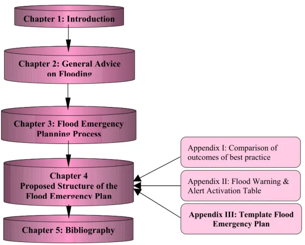
1.8 Structure of the Guidance
This guidance is structured in such a manner as to inform the reader of what flood emergency plans are, give general advice on flooding, and to give an initial background understanding of cause and effect of flood events.
Chapters 3 & 4 will outline the flood emergency planning process and give guidance on the content of the template flood emergency plan.
Figure 2:Outline Structure of this Guidance Document
2. GENERAL INFORMATION ON FLOODING
2.1 Summary
Flooding is generally caused by a combination of human activity and natural physical
conditions, and consequences vary. In determining the risk posed by flooding, account needs to be taken of the likely depth, speed and extent of inundation and the potential for
anticipatory action to be taken as a result of pre-planning and advance warnings. This chapter outlines some general information on the causes, impacts, probability and sources of flooding, some flood facts and the impact of climate change.
2.2 Causes
Flooding is a natural event; the water cycle is a balanced system. Water flowing into one part of the cycle (like streams) is balanced by water flowing back to the sea. Sometimes, however the amount flowing into one area is greater than the capacity of the system to hold it within natural confines. The result is a flood, which occurs when the amount of water arriving on land (from rainfall, snow melt, surface flow, flow in watercourses or inundation by the sea) exceeds the capacity of the land or drainage-system to discharge that water. It can occur on any location but mainly occurs on land adjacent to watercourses (fluvial flood plains) or
low-Chapter 1: Introduction
Chapter 2: General Advice on Flooding
Chapter 3: Flood Emergency Planning Process
Chapter 4
Proposed Structure of the Flood Emergency Plan
Appendix I: Comparison of outcomes of best practice
Appendix III: Template Flood Emergency Plan
Appendix II: Flood Warning & Alert Activation Table
lying ground next to the coast (coastal flood plains) or ponding of surface runoff in urban areas.
The following could be additional contributing factors to flooding impacts,
• Building developments in floodplains, where they are vulnerable to flood hazards;
• Built development in catchments and other changes in land use, that increase the rate and volume of run off in a catchment;
• Sediment movement changing river cross-sections and affecting flood levels
• Lack of maintenance of flood defence systems, watercourses, culverts (including flood storage areas around them) and road gullies, particularly where this leads to channel blockage
• Canalisation, modification and diversion of rivers and watercourses, which increase the rate of flow and decrease the time taken for water to travel within a catchment
• The building of structures e.g. (embankments), which restrict flows over historical flood plains and thereby create additional flood risks both upstream and downstream.
• Land management practises that increase blockages of hydraulic structures.
2.3 Impacts
The severity of impact or damage caused by flooding depends on:
• Flow Velocity; (the larger the flow velocity the greater the risk of damage and injury).
• Warning time and rate of onset of inundation, this will dictate the amount of time to prepare.
• Predictability of flooding.
• Duration of inundation;
• Depth of inundation.
• Contaminants.
• Type and number of risk receptors (e.g. flood plain properties)
The consequences of flooding vary with land use. Overtopping and possible failure of a flood defence protecting a densely populated urban area is an extreme risk; the same event affecting agricultural land is unlikely to involve a serious threat to life or the same degree of economic consequence. Rapid flows due to flash flooding or inundation by the sea following failure or overtopping of defences generally pose a greater risk to life than a steady rise in water level. Significant flooding affecting a wide area can have substantial economic and public health impacts on affected communities and infrastructure.
Flooding is generally accompanied by poor weather conditions. Significant flood events can be complex, and they can occur at any time day or night and last for an uncertain period of time. Responders may have to work in dangerous conditions, there may be considerable numbers of people displaced from their homes and there may be considerable business, infrastructure and utility interruption. All of the above are factors, which will have an influence on how to prepare a response in a flood emergency.
2.4 Probability of Flooding
Probability is the likelihood of an event occurring. In flood terms, probability is often referred to as a return period, e.g., a 50-year flood event is a flow or tide level that is expected to be equalled or exceeded on average once every fifty years.
This can be misinterpreted as meaning that a flood will not be exceeded more often than indicated by the return period. In other words, a 1 in 100 year flood does not necessarily occur only once every 100 years, they occur on average once every 100 years.
The probability or likelihood that a location will flood in any one year is expressed in the following terms:
Figure 2: Probability Table.
Chance of flood event every year Return
period Annual Exceedance Probability (AEP) ‘Odds’ 1 in 20 yrs 5% chance of a flood happening each year 20: 1 1 in 100 yrs 1% chance of a flood happening each year 100: 1 1 in 200 yrs 0.5% chance of a flood happening each year 200: 1 1 in 1000 yrs 0.1% chance of a flood happening each year 1000:1
The estimation of probability is prone to uncertainty due to the use of short periods of record or to changing conditions such as river basin urbanisation, channel maintenance or
degradation and climate change.
2.5 Sources of Flooding
Floods can be categorised by the source of the event. The characteristics of each of the following flood sources will assist in determining the actions taken to alleviate the flood consequences.
2.4.1River/Fluvial flooding
The principal source of river flooding is excessive rainfall or snow melt within a limited period, which overwhelms the drainage capacity of the land or drainage systems, particularly when the ground is already saturated or when drainage channels become blocked. Weather patterns determine the amount and location of rain and snowfall. Unfortunately the amount and time over which precipitation (rainfall) occurs is not consistent for any given area. A number of factors can combine with exceptional precipitation to exacerbate flooding e.g., heavy snow melts, water-saturated ground, unusually high tides, and drainage modifications. A flash flood can occur when extensive saturation of high ground accompanied by intense short-duration rainfall in a small catchment or in a heavily urbanised catchment results in the sudden release of large volumes of water along narrow channels from high ground to low
lying locations. Extreme rainfall events may be forced by airflow over mountains, weather fronts and convective storms. The most extreme events involve a rapid uplift of moist air in the same location for a long time. This type of meteorological event can cause other effects including landslides. Characteristics of the local flood catchment area will determine if and how the flood develops.
2.4.2Coastal Flooding
Inundation by the sea on coastal areas is potentially caused by unusually high tide, storm surge, hurricanes (cyclonic storms) and wave activity including tsunamis. Coastal floods may also be caused by structural failure of defences with some locations subject to combinations of tidal and river impacts. Long-term processes like subsidence and rising sea level as a result of global warming can lead to encroachment of the sea on land.
2.4.3Dam Burst, Defence Failure or Overtopping
Dams occur as human constructed features, or as natural features constructed possibly by landslides, or blockages by ice. Human constructed dams are built for water storage,
generation of electrical power, and flood control. Flood defence systems (e.g. levees, earthen banks, walls) are designed to protect vulnerable low-lying areas and also hold water levels above the surrounding natural ground level.
Irrespective of their construction, failure can result in the sudden release of large volumes of water leading to catastrophic flooding including potential loss of life.
2.6 Impact of climate change
A very significant volume of research has been undertaken, and is ongoing, in the field of climate change; with respect to both causes and impacts of change. Recent publications concerning climate change that are of particular relevance are:
− Climate Change 2007: The Physical Science Basis; (Intergovernmental Panel on Climate Change [IPCC], 2007)
− Annual Report 2004 (Community Climate Change Consortium for Ireland [C4i], Met. Éireann, 2004)
− Climate Change: Scenarios and Impacts for Ireland (Environmental Protection Agency, 2003) − Key Meteorological Indicators of Climate Change in Ireland; (Environmental Protection Agency,
2007)
Based on the above research, it is predicted that changes in climatic parameters in Ireland are projected to have impacts on sea level, storm event magnitude and frequency, and rainfall depths, intensities and patterns. The IPCC (2007) projects that global mean sea level will rise between 0.18m and 0.59m over the 21st century, with further rises expected beyond this, and that over this period more frequent heavy precipitation events will occur, particularly in high-latitude areas (such as Ireland).
On the basis of increased rainfall and rising sea levels, the national level of flood hazard (frequency and degree of flooding) would be expected to increase. This increase in hazard can be expressed as increases in the:
− severity of flooding for given flood event probabilities, − frequency of flood events of a given magnitude,
− likelihood of flooding in areas previously not considered to be at risk.
The increases in hazard would, in turn, be expected to give rise to an increased level of flood risk (likelihood and degree of damages arising), with existing people and properties at risk experiencing more frequent or severe flooding, and more people and properties becoming subject to risk. The degree of protection offered by existing river, estuary and coastal flood defences would also fall, as the flood events the schemes were designed to protect against would become more frequent.
2.7 Flood Facts
It must be remembered that there is always the possibility that lives will be lost on land or at sea during a flood event.
Assuming a general knowledge about the locality, the following can be considered as likely to arise under flood conditions:
• Dislocation of services: road transport and access may be impeded by floodwaters;
• Power failure at pumping stations and sewerage treatment works may cause additional flooding and pollution hazards;
• Hydraulic structures may be damaged or blocked by floating objects;
• Collapse of walls/properties and the displacement of manhole covers, scour holes may present new, underwater hazards;
• Surfaces become slippery making them a health hazard;
• Changes in local flow regime may occur as the result of the floodwaters such as scour holes, manhole covers missing etc.
• Health impacts may be substantial, affecting many people at the same time.
• People may be displaced, (potentially for periods of up to or beyond a year) physically injured or exposed to chemical and biological hazards
• Floods can also cause anxiety and have psychological impacts on the affected communities
• Foul sewage and other pollution may cause contaminated water containing a number of pathogens.
• Disruption to communications
• Breakdown of law and order.
• Floods can have significant economic impacts; the estimate of losses for the Carlisle floods of 2005 was in excess of 450 million pounds sterling. In the Flood Studies Update Report an estimated annual average damage of approximately €250,000 to €2.6m based on studies carried out at that time is mentioned.
• Power failure due to a flooded power station.
3.1 Intr oduction to planning for flood events
The review of current best practice suggests an approach to developing future flood emergency plans for the Irish situation. The following sections expand on the knowledge gained from meetings with local authorities and the review of current best practice referred to in Chapter 4 of this guide. The aim of the remainder of the Guidance is to give simple
straightforward guidance on how to develop a Flood Emergency Plan that is both workable from the point of view of the agencies involved, while also affording the necessary level of assistance to the communities who are potentially at risk.
3.2 Preparing for flood events
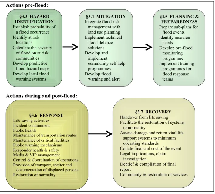
International best practice advocates a risk management approach to the hazard of flooding. The systems approach to emergency management outlined in the Framework is useful to divide the actions required to manage flood events into phases e.g.: actions before the arrival of the flood waters (the incubation/return period) and actions required during and post the arrival of the floodwaters. The following figure illustrates the components of each phase: Figure 3: Flood Event Phases
Actions pre-flood:
Actions during and post-flood: §3.3 HAZARD IDENTIFICATION Establish probability of a flood occurrence Identify at risk locations
Calculate the severity of flood on at risk communities Develop predictive
flood hazard maps Develop local flood warning systems
§3.4 MITIGATION
Integrate flood risk management with land use planning Implement technical
flood defence solutions Develop and
implement
community self help programmes
Develop flood warning and alert mechanisms
§3.5 PLANNING & PREPAREDNESS
Prepare sub-plans for flood events Identify resource needs Develop pre-flood monitoring programme Implement training programmes for flood response teams §3.6 RESPONSE
Life saving activities Incident containment Public health
Maintenance of transportation routes Maintenance of critical facilities Public warning mechanisms Responder health & safety Media & VIP management
Control & Coordination of operations Provision of transport, shelter and
documentation of displaced persons Restoration of normality
§3.7 RECOVERY
Handover from life saving
Facilitate the restoration of systems to normality
Assess damage and return vital life support systems to minimum operating standards
Collate financial cost of the event Legal implications, claim
investigation
Debrief & compilation of final report
3.3 Hazard Identification and flood history
Hazard identification requires a knowledge and understanding of the extent and degree of flood risk present in the area. Access to hydrological information for the area, to historical and predictive flood maps and knowledge of the communities and infrastructure likely to be at risk from flooding are essential for the hazard identification process. Hazard Identification and Risk Assessment is dealt with in Chapter 2 of the Flood Emergency Plan Template in Appendix III of this document.
3.3.1Hazard Information
As an aid to identification of the flood hazard in a particular locality the website
www.floodmaps.ie should be consulted. The site contains reports of past events and will assist the authority in compiling a comprehensive collection of historical flood hazard maps to assist with the identification of locations that are prone to flooding. They are also a useful source of information for other related purposes such as land-use zoning, development control, planning of infrastructure, identification of properties at risk, flood warning and identification of
response priority areas. They can also be used to raise a general awareness amongst the public of the need to prepare for the possibility of future floods.
Some local authorities that have encountered severe flood events in the past have undertaken a programme of developing predictive flood hazard maps, based on modelling techniques. Where these are available they can be an important source of information.
Flood maps can be used to identify:
• Communities vulnerable to flooding and those at risk from breaches in defences;
• Critical infrastructure such as treatment plants, pumping stations, industrial complexes, electricity substations, telecommunications exchanges etc and vulnerable public buildings such as schools, hospitals etc. which are located in flood risk areas;
• Traffic and evacuation routes and corridors;
• Traffic diversion routes.
• The location of flood defence resources (equipment, sandbags etc);
• The locations of transit areas and temporary rest centres for evacuation purposes;
• Areas likely to flood and the extent and depth of flooding;
3.3.2Functions of the PRA(s) in Hazard Identification
Each of the PRA(s) have a role during the hazard identification phase. The Major Emergency risk assessment process provides the means to identify the potential for significant flooding in an area. It is recommended that the local authority collate the hazard information on flood risk maps, to be held by the Local Authority (pre-determined lead agency for flooding). The Local Authority should consult with the OPW and other bodies to identify existing and future flood risks. If no information is available on this, Local Authorities should assess their flood risk following OPW standards. The PRA roles in hazard identification are as follows:
Local Authority
• Produce base flood hazard maps showing:
o River catchments and flood plains;
o Areas that have historically flooded;
o Low lying coastal areas at risk;
o Water levels, flood pathways;
• Identify and prioritise locations for structural and temporary defence solutions;
• Identify and address issues highlighted by previous flood events;
• Identify at risk locations;
• Identify vulnerable communities and critical infrastructure within those at risk; locations
• Identify assembly areas for forward transportation of evacuees;
• Assist an Garda Síochána with route mapping for flood response; An Garda Síochána
• Use flood hazard maps to identify networks for route planning.
• Identify transport-holding areas adjacent to flood hazard areas.
• Prioritise routes for emergency transport into flood-affected areas.
• Identify evacuation routes to assembly areas for forward transportation to rest centres
• Identify routes, which may be inaccessible and undertake alternative traffic route planning to minimise the impact of flood-affected networks on routine traffic management.
Health Service Executive
• Identify vulnerable persons in the at risk areas.
• Identify medical facilities, care homes etc. at risk.
• Identify alternative accommodation for patients who have to be moved
3.4 Mitigation
Mitigation options available in the pre-flood period include the provision of temporary defences, public advice and alerting mechanisms and addressing business continuity issues. Mitigation options include:
• Installation of engineered flood defences (embankments, walls, weirs, river channelling) where the cost-benefit analysis indicates such are warranted.
• Identification of locations where demountable defences would be appropriate.
• The formulation of a sandbag policy and issues relating to their distribution during an event
• Development, design and implementation of a local flood warning/alerting system;
• Integration of flood risk assessment with land-use planning.
Structural solutions to mitigate flood impacts are primarily within the remit of the OPW when they exercise their role in the provision of flood relief schemes generally in partnership with the relevant local authority.
3.5 Planning and Preparedness
Many of the generic arrangements for coordination of multi agency response are directly applicable to flooding emergencies. The Framework Document (section 4.3.1: page 38) specifies that each Principal Response Agency (PRA) prepare sub-plans for severe weather emergencies including flooding:
“Each Local Authority should have, as a specific sub-plan of its Major Emergency Plan, a plan for responding to severe weather emergencies, whether a major emergency is declared or not. The Local and/or Regional Co-ordination Centres for Major Emergency Management may be activated to manage the response to a severe weather event, whether a major
emergency is declared or not. The other principal response agencies should include sub-plans for responding to notifications from the Local Authorities of severe weather warnings, whether a major emergency is declared or not, and carry out their normal functions in emergency management in such situations as well as participating in co-ordination groups.” The responsibilities of each organisation in relation to preparation of a flood emergency plan are as follows:
3.5.1Functions of the PRA(s) in planning for response
Local Authority
• Identify and ensure coordination structures to fulfil the “lead agency” role in responding to flood events as required.
• Developing a flood emergency sub-plan in conjunction with other response agencies as outlined in the framework, §3.5.2 of this guidance, and chapter 4.
• Linking inter-agency flood emergency planning in accordance with Section 5.4.2 and Appendix F.7 of the framework.
• Identifying and preparing resources required for flood response & recovery under the following headings:
o Human
o Financial
o Equipment
• Nomination and establishment of a Flood Assessment Team from existing engineering resources, and provision of training in the use of the flood forecasting system.
• Establishing or linking with a source providing a comprehensive system of flood hazard mapping to enable information dissemination and predictive and forecast modelling for flood events
• Establishing standby and callout arrangements and addressing any capability gaps
• Establishing a continuous programme of development, training and exercising (alongside those likely to have a stake in potential extreme flood events).
• Identifying assembly areas and temporary rest centre accommodation for persons evacuated from their homes
• Developing procedures for the draw down of emergency finance during an event
• Preparing a plan in partnership with the HSE for the welfare of persons evacuated from their homes
• Developing safety procedures for responders operating in flood conditions;
• Identify required recovery operations.
An Garda Siochana
• Developing agency specific procedures to incorporate support from the voluntary agencies and others in relation to the functions of AGS as outlined in the Framework.
• Identifying and preparing resources required for flood response & recovery under the following headings:
o Human
o Financial
o Equipment
• Preparing evacuation plans and protocols for public warning
• Preparing evacuation route plans.
• Preparing traffic diversion plans
Health Service Executive
• Developing agency specific procedures to incorporate support from the voluntary agencies and others in relation to the functions of the HSE as outlined in the
Framework, page 24 of Template (Appendix II of Guide) and Appendix 5 of Protocol.
• Identifying and preparing resources required for flood response & recovery under the following headings:
o Human
o Financial
o Equipment
• Developing advice and guidance on public health issues relative to flood events
• Developing procedures for the provision of welfare and medical support to displaced communities resident at local authority temporary rest centres
• Developing arrangements for the specialist transportation of such persons to alternative accommodation
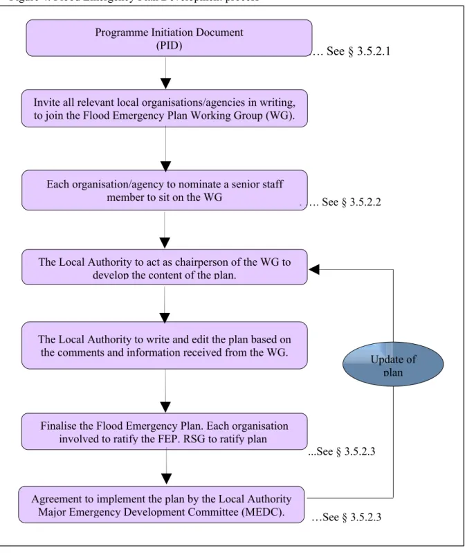
3.5.2Flood Emergency Plan development process
Prior to documenting the Flood Emergency Plan, it is recommended that in accordance with the Protocol, the local authority put in place a specific Flood Emergency Plan Working Group (WG) to meet regularly to guide the development of the Flood Emergency Plan. This working group will operate under the aegis of the Regional Steering/ Working group. A general outline of the suggested process of developing a Flood Emergency Plan is as follows:
Figure 4: Flood Emergency Plan Development process
…. See § 3.5.2.1 . …. See § 3.5.2.2 ...See § 3.5.2.3 …See § 3.5.2.3 Invite all relevant local organisations/agencies in writing,
to join the Flood Emergency Plan Working Group (WG).
Each organisation/agency to nominate a senior staff member to sit on the WG
The Local Authority to act as chairperson of the WG to develop the content of the plan.
The Local Authority to write and edit the plan based on the comments and information received from the WG.
Finalise the Flood Emergency Plan. Each organisation involved to ratify the FEP. RSG to ratify plan
Agreement to implement the plan by the Local Authority Major Emergency Development Committee (MEDC).
Programme Initiation Document (PID)
Update of plan
3.5.2.1 Programme Initiation Document (PID).
The PID sets out the scope, main facts and details of the programme to be undertaken. It includes aims, timescales, and tasks of the Flood Emergency Plan Working Group.
3.5.2.2 Suggested members of the Working Group (WG)
Where it is determined organisations/agencies/sectors have a significant role to play at local level during the response and/or recovery phase of a significant flood event they should be approached to appoint a representative or be involved with the principal response agencies on the Flood Emergency Plan Working Group, example of such support groups are:
(i) Defence Forces (consisting of the Army, Air Corps, Reserve Defence Forces) (ii) Irish Coast Guard
(iii) Irish Red Cross Society (iv) Voluntary Groups (v) Community groups (vi) Private Sector
It is advised that all efforts shall be made to ensure that all organisations have nominated the appropriate person from within their ranks who will be able to satisfactorily attend all meetings of the Working Group. Working group meetings should endeavour to be
participative and productive for the time committed. To minimise delays in producing the working Flood Emergency Plan, there should be consistency in the make up of the group. Members will be involved in, and have an oversight of resources available for flood response within their organisation. Through regular meetings of the Working Group, the content of the plan will be discussed among all members. It is recommended that the person nominated from each organisation should as far as possible satisfy the following criteria:
i Be a senior member within their organisation;
ii Have the authority to commit the resources of their organisation to the flood response; iii Be involved in flood risk or water related issues or emergency management;
3.5.2.3 Finalising and agreeing the plan
Before adopting the plan, each of the organisations should get approval and sign-off from their senior management. This will also involve agreement from the Regional Steering/ Working group. Plan maintenance will follow the same process as that outlined for the Local Authority Major Emergency Plan.
3.5.3Overview of Organisations involved in flood response activities
The local authorities are the pre-determined principal response agency to lead in the
preparation of flood emergency response plans. The framework document encourages each of the principal response agencies to make provision for mutual aid agreements to be put in place with agencies/organisations who may assist them in the response to emergencies including flooding. The Office of Public Works acts in an advisory capacity, and gives
guidance to the local authorities in the preparation of flood emergency response plans. In responding to flooding, a broad range of the local authority services including engineering and administrative services will respond. The local authority (including where appropriate the local authority Fire Service and Civil Defence) takes the lead in co-ordinating the response of the other principal response agencies and public and voluntary organisations.
3.6 Coordination of Flood Emergency Response
The response stage is the phase of the flood emergency response plan which deals with the management and execution of a range of activities during the development, passage, and recession of a flood. This phase will draw upon the prevention and preparedness operations to ensure adequate action is taken to reduce the impact of flooding.
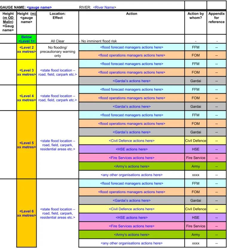
3.6.1 Flood Warning & Alerting levels
The chart below illustrates the flood warning alert levels and the levels of response required as a result of the analysis and monitoring of local flood conditions by the Flood Forecast Team of the local authority (see section 3.6.2 below). Using the Irish Meteorological Office (Met. Eireann) public service severe weather forecasts and/or information derived from automated flood gauges local flood conditions can be monitored and acted upon by the designated local authority Flood Assessment Team.
Figure 5: Flood Warning Categories and Response Action Levels Chart Warning Type Warning Level ALERT LEVEL 1 ALL CLEAR CODE GREEN A
ALERTLERT L LEVELEVEL 2 2 W
WARNINGARNING C
CODEODE Y YELLOWELLOW
ALERT LEVEL 3 WARNING CODE ORANGE ALERT LEVEL 4 WARNING CODE RED
Flood Type NO THREAT POSSIBILITY OF FLOODING FORECAST MINOR FLOODING FORECAST MAJOR FLOODING FORECAST Features of the flood
There are NO Flood Watch or Flood Warnings in force. No imminent risk of a level that requires further monitoring
One or more meteorological conditions exist which could make flooding possible. Overtopping is likely to occur at a level that could affect roads and fields adjacent to defence. No buildings affected. Some overtopping of defences; flooding of roads; and/or local flooding of some properties & businesses. Properties will be flooded. Increased disruption to road traffic. Possible evacuation required Severe flooding is expected; imminent danger to life and/or property. Widespread flooding of roads & rail; and/or properties & businesses. Properties will be severely flooded, major disruption to roads and infrastructure. Evacuation required Flood Response ROUTINE DRAINAGE SOLUTIONS/ MAINTENANCE ROUTINE PREPARATIONS LOCAL AUTHORITY RESPONSE RESOURCES MOBILISED: ADVISE ALL ESCALATION OF RESPONSE: ADVISE ALL PRAs, ACTIVATE MAJOR
ONLY & INFORM MEDIA
RESPOND & INFORM MEDIA
PLAN
Outlining the involvement of each participating organisation at each stage is useful when preparing an FEP.
3.6.2 Flood monitoring and assessment
Flood monitoring and assessment will be ongoing throughout all stages of the flood response. Where a local authority has identified significant flooding as a hazard during the risk
assessment process they should as part of the preplanning process for flood emergency response undertake to appoint from within the local authority a “Flood Assessment Team”. This team can monitor weather conditions and provide an analysis of the flood risk before and during an event as well as providing specialist advice to the operational services deployed to a flood event.
This team should initiate contact with Met Éireann, via the contact points listed in figure 5, and act as liaison between the weather services, the local authorities Crisis Management Team (CMT) (see protocol Appendix 3 and glossary of terms) and the Local Coordination Group (LCG) as provided for in the framework and illustrated in Appendix III of this document It is the responsibility of the local authority Flood Assessment Team/Flood Assessment Manager ( refer to §) to determine the level of response the expected flood situation will require e.g. no further action required, the activation of an internal operational response (refer to §), or the requirement for increased levels of Inter agency Co-ordination (refer to §), which may require activation of the Major Emergency Plan (refer to §). The Flood Assessment Manager should be identified as part of the Flood Assessment Team, and should be from the local authority. The Flood Assessment Manager will have training on the flood forecast system that is in place, and will communicate any potential flooding situation to the local authority Crisis Management Team as appropriate. In circumstances where there is an
automated warning system in place, caution should be exercised, and cross-referencing in the form of manual inspection should be used as appropriate.
3.6.3 Operational Level (on-site during minor flood events)
In the Irish context, the initial operational response is undertaken by general operatives from the council’s outdoor staff and/or Fire Service as the local authority’s principal emergency service This would involve placing of road signs to warn of flooding, deployment of a certain amount of sandbags, localised pumping and/or increased levels of gully cleaning. The internal operational response will be deployed for localised flooding of short duration and
insignificant impact, causing minimal damage. Such events will be within the remit of routine procedures by the On Site team(s) and there will be no requirement for the activation of a (inter-agency) Local Coordination Group or the Local Authority Crisis Management Team (LA CMT).
If routine procedures prove inadequate to mitigate the occurrence and the flooding has
become more severe and/or there is the potential for a more severe event to be realised, a local authority flood management team which will include persons with appropriate skills,
knowledge and experience for flood assessment, warning and operations management will direct local authority operations. In circumstances that require the declaration of a major emergency i.e. an escalation in scale and duration the local authority Flood Management Team may become the LA Crisis Management Team (LA CMT) in accordance with the terminology for Major Emergency Management.
Where the impact of the floods are of such a scale as to warrant inter-agency cooperation e.g. resources external to the local authority response are required, in accordance with internal procedures the Local Coordination Group (LCG), working off-site, and the On Site
Coordination Group (OSCG), working on-site will be activated. The LA will establish both an Off-Site Local (LCC) and On-Site Coordination Centre (s) (OSCC). A representative of all agencies involved in the response will attend at the LCC and the OSCC.
3.6.5 Escalation of the Response to a Major Emergency Escalation of a flood event
Response Capability within Engineering Services Engineering Services requires assistance Local Authority requires external assistance Inter-Agency Significant Local Flood Event Inter-Agency Regional Flood Event Engineering Services Maintenance Section Routine Operations
Flood Assessment Monitoring
Flood Assessment Team
Engineering with Support
Flood
Operations
Local Authority Chair
Local Co-ordination Group (LCG)
Local Authority Chair
Regional Co-ordination Group Flood Incident Flood Emergency Major Emergency Regional Major Emergency Continuous monitoring
Flood Assessment Team
Flood Issue
Sections activated Type Event Scale Organisation
The activation of the LCG and OSCG may if the circumstances are warranted require the declaration of a major emergency, the LA should ensure that in the lead in period to such a declaration all of the agencies who have a function in the flood emergency response plan are kept informed of developments as per the communications procedures set out in the plan. The Local Co-ordination Centre will most likely be located at the local authority County buildings/ City Hall. However, where there is a possibility that the local authority buildings may be affected by the flooding an alternative centre should be designated.
Regional Co-ordination will be activated if the Local Co-ordination cannot cope with the flood situation. This may entail commissioning neighbouring agencies to help in the response effort.. It is envisaged that Regional Co-ordination will rarely be activated, but provision should be made for scaling up to regional level within the flood response plan. Figure 6 sets out the escalation of a flood event from routine response to a regional level major emergency.
4. PROPOSED STRUCTURE OF THE FLOOD EMERGENCY PLAN
4.1 Introduction/General
In 2007 the OPW completed a review of international best practice in flood response, and pilot studies in Fermoy, Mallow, and Clonmel. In this Chapter, an outline proposal for the structure and content of Flood Emergency Plans in Ireland based on the review of best practices and pilot studies is given. For further details and a comprehensive description for each country studied, refer to the report entitled “Review of Best Practice – Stage I of the Flood Emergency Response Project” (OPW 2007).
4.2 Summary of notable features of international flood response plans
This section outlines some important and relevant points that have come from the
examination of best practices. Based on this review, the following useful items were noted: a) The theme that permeates through all emergency response procedures in Ireland and other
countries is that of the continuous process of Hazard analysis, Mitigation, Preparedness, Response and Recovery. In the case of a flood, the hazard is clearly defined, and the number of phases is reduced to the latter four phases noted. None of these phases are independent of each other (see Figure 4). There will be some overlap of the stages, and it is important to note that once a flood emergency response plan is adopted, there will be a continuous process of dissemination of information, planning, and review and training throughout the year.
Figure 7: The five stages of Emergency Management (source: “A Framework for Major Emergency Management”,)
b) Educating and informing the community is seen as being very important.
c) Identifies the important role of the media in the information process before and during the event.
d) A reliable flood forecasting system should be in place.
e) Sandbag/Flood proofing procedures in Ireland should be looked at with a view to arranging common policy amongst local authorities.
f) All countries place much emphasis on training exercises and testing of their plans, which creates familiarity amongst those involved and improves reaction times in the case of a flood.
g) Resources are of critical importance. Obviously each flood response plan needs to keep in mind the limitations on resources available, and should also look into acquiring additional aid and assistance from other agencies.
h) The concept of issuing quick reference action guides to general operatives and others on the ground during an emergency is an option that could be explored.
i) All plans studied contain the following fundamental features to a greater or lesser extent: -Identification of flood risk and hazards
-Flood Warning and stages of warning -Roles and Responsibilities
-Hierarchical levels of command -Information and Media
-Detailed description of response operations -Emergency training and exercises.
j) Other items addressed include, but are not limited to: resources, contact details, sandbag policies, distribution lists, glossary of terms, validation and review of plans.
k) Throughout the entire flood response plans studied three different levels of command may be invoked during a flood emergency, Operational, tactical and strategic levels.
l) The work being carried out under the NOAH Project- FLIWAS3 may be of future
relevance to Irish organisations involved in flood response.
4.3 Recommended Content of the Flood Emergency Plan
During the review of best practice, the main features of flood response plans in those
countries studied were noted. Each of these main features have been assessed with regard to their importance and usefulness within the Irish context, and are illustrated in Table A1 in Appendix I.
The proposed Flood Emergency Plan (FEP) structure in section 4.4 contains features selected from all of the Irish and international flood response plans examined which have relevance to the Irish situation. The FEP is a sub-plan of local authorities Major Emergency Plan and there are common areas where elements of the FEP will have been addressed in the MEP, where this occurs the information/directions contained in the MEP take precedence and should be reflected in the FEP.
The FEP is divided into three sections, and consists of a Main Plan, the Appendices, and the Agency Specific Procedures.
3 FLIWAS - Flood Information and WArning System is an Interreg IVb funded project. It uses a web based platform to record and manage flood response procedures.
(a) The Main Plan has a broad framework and describes the approach to flood emergency response management, planning and operations.
(b) The Appendices are item specific. These are required when the response to a flood cannot be expressed generically in the basic plan. They give additional information to that described in the basic plan. (Described in Appendices A-O of the FEP)
(c) The Agency Specific Procedures are components of the FEP that provide specific information and a description of response operations for each individual response agency. They expand upon information contained in the basic plan. The procedures can be adopted in the FEP or can be retained by the individual organisation.
Based on the review of best practices, and experiences throughout the country, the format was chosen as set out in section 4.4 for the suggested structure of the Flood Emergency Plan. The proposed structure and other suggestions contained within the template will be the subject of review by the relevant parties after usage.
4.4 Recommended Flood Emergency Plan Structure
Appendix III of this guide sets out a template for a Local Authority FEP. The advice and recommendations included in the Template are based on the outcomes of the “Review of Best Practices (OPW, 2007) and the pilot studies undertaken by the OPW.
Figure 8: Flood Emergency Plan Structure -Cover Page
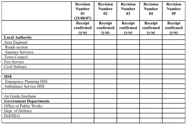
-Plan Revision List -Executive Summary -Table of Contents
1. Introduction to the Flood Emergency Plan
2. Area of Operation and Flood History – Risk Assessment 3. Roles and Responsibilities
4. Flood Warning Stages and Action Plan. 5. Information Management and the Media 6. Appendices
A List of contacts B Maps
C Field equipment, facility resource list, and main buildings D Sandbag/Flood proofing policy and procedures
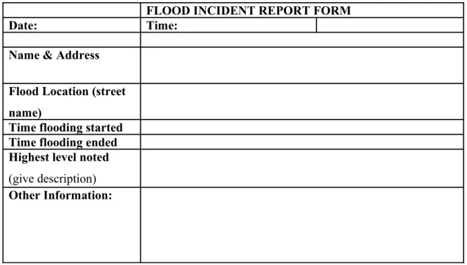
E Evacuation and Vulnerability registers F Incident report form and flood records G Traffic management
H Recovery and clean-up operations
I Flood Forecasting and Warning - system details
10. Safety, health and welfare considerations K Training and Testing of the Flood Emergency Plan
L Flood Emergency Plan distribution list M List of Definitions
N Public Information
O Mutual aid agreements with other local authorities. P Details of Instructions for temporary flood defences 7. Agency Specific Procedures
(i) Gardai
(ii) Local Authority Fire Services Civil Defence
Engineering Services (iii) Permanent Defence Forces (iv) HSE (v) Support Services
Main Plan
Plan
Appendices
Agency
Specific
Procedures
5. GLOSSARY OF TERMS
Crisis Management Team (CMT)
A team of Senior Managers chaired by the Head/ Designate of the Organisation convened to direct and control the resources of that organization in response to an emergency situation. Term can be
interchangeable with Flood Management Team during a flood event dependent on severity.
Danger Area
Area where there is a definite risk to rescue personnel, over and above that which would normally pertain at emergency operations.
Debris
The scattered remains of assets broken or destroyed in a hazard event. Debris caused by a wind or water hazard event can cause additional damage to other assets.
Evacuation and/or self evacuation
A process by which people are moved from a place where there is immediate or anticipated danger to a place of safety,
Flood Assessment Team
Experts from the Local Authority who are involved in monitoring and analyzing data relating to weather and hydrological information in order to provide information on the potential and scope of flood conditions. This term is interchangeable with Flood Forecast Team.
Flood Depth
Height of the floodwater surface above the ground surface.
Flood Hazard Area
The area shown to be inundated by a flood of a given magnitude on a map.
Flood Risk Zone
A geographical area shown on a map that reflects the severity or type of flooding in the area.
Floodplain
Any land area, including watercourse, susceptible to partial or complete inundation by water from any source.
Infrastructure
Refers to the public services of a community that have a direct impact on the quality of life.
Infrastructure includes communication technology such as phone lines or Internet access, vital services such as public water supplies and sewer treatment facilities, and includes an area's transportation system such as airports, heliports, highways, bridges, tunnels, roadbeds, overpasses, railways, bridges, rail yards, depots; and waterways, canals, locks, seaports, ferries, harbours, dry-docks, piers, and regional dams
Lead Agency
The principal response agency that is assigned the responsibility and mandate for the coordination function.
Local Coordination Group (LCG)
The activation of the inter-agency “Local Co-ordination Group” (the “Off-site Coordination Centre” in the 1984 Framework) is another key level of co-ordination. Representatives from the three PRA’s whose function is to facilitate strategic level co-ordination, make policy decisions, liaise with regional / national level coordination centres if appropriate, and facilitate the distribution of information to the media and the public.The On-Site Coordination Group (OSCG) will assemble at the incident scene.
Local Coordination Centre (LCC)
The Local Co-ordination Centre is a pre-nominated building, typically at county or sub-county level, that has the appropriate support arrangements in place to facilitate the effective working of the Local Co-ordination Group.
6. BIBLIOGRAPHY
-Office of Public Works, 2007. ‘Review of Best Practices – Stage I Report’ -Office of Public Works, 2007. ‘Draft Final Fermoy FEP’(internal document) -Office of Public Works, 2007. ‘Draft Final Mallow FEP’(internal document)
-Department of the Environment, Heritage and Local Government, Nov. 2007. ‘ Protocol for multi-agency response to flood emergencies’
-Causes of Flooding (UK:ODPM Planning Policy Guidance 25)
-Dublin City Council, 2006 Draft. ‘Hazard Specific Incident Response Plan No. 8: Flood Incident Plan’ (Draft)
-Dublin City Council, 2005. ‘Flood Emergency Management: Report FEM 01-Inventory of Exemplary Approaches’
-Clonmel Borough Council, 2006. ‘Draft-Flood Response Plan’
-Mallow Town Council, 2006. ‘Flood Warning for Mallow – Draft procedure’ -Cork City Council, Dec. 2004. ‘Severe Weather Plan’
-Department of the Environment, Heritage and Local Government, Sept. 2006. ‘A Framework For Major Emergency Management’
-Office of Public Works, 2004. ‘Report of the Flood Policy Review Group’
-Inter-Departmental Committee on Major Emergencies, February 2001. ‘Report on November 2000 flooding’
-Office of Public Works, 2004. ‘Flood Response – A Guide For Ireland’ (Draft internal report)
7. FURTHER READING & RESEARCH
-The Office of the First Minister and Deputy First Minister, 2007. ‘A guide to emergency planning arrangements in Northern Ireland’
-HM Government, 2005. ‘Emergency Preparedness: Guidance on Part 1 of the Civil Contingencies Act 2004, its associated Regulations and non-statutory arrangements’ -HM Government, 2005. ‘Emergency Response and Recovery: Non-statutory guidance to complement Emergency Preparedness’
-Northern Ireland Office of the First Minister and Deputy First Minister, 2005. ‘A Guide to Plan Preparation’
-Bedfordshire and Luton Local Resilience Forum, ‘Bedfordshire and Luton Flood Response Plan’
-Havant Borough Council, Oct. 2003. ‘Operational Flood Plan’
-Dartford Borough Council, June 2004.‘Dartford Borough Council flood warning response plan’
-Emergency Planning and Core Resilience Team, Essex County Council, Jan. 2006. ‘Flood Plan for Essex’ version 2
-Gloucestershire County Council, March 2004. ‘Emergency Response Guide’ Fourth Edition -Gloucestershire County Council Emergency Management Service, December 2003. ‘Flood Response in Gloucestershire’
-Vale Royal Borough Council, March 2005. ‘Flood Incident Response plan for Northwich’ -Peridian Group, Inc., July 2002. ‘Johnston County Flood warning/flood forecasting: Feasibility and implementation plan’
-Baltimore County Government, Feb. 2000. ‘Emergency Operations Plan’
-Goochland County Fire Rescue Office, 2001. ‘Goochland County Emergency Operations Plan’
-FEMA, Sept. 1996.‘State and Local Guide (SLG) 101: Guide for All Hazard Emergency Operations Planning
-Dept. of Public Safety, Vermont Emergency Management, March 1996 ‘Model Town Emergency Operations Plan’
-Dept. of Natural Resources and Parks, Water and Land services division, May 2006. ‘King County Flood Hazard Management Plan’
-U.S. Dept. of Homeland Security, March 2004. ‘National Incident Management System’ -U.S. Dept. of Homeland Security, Dec 2004. ‘National Response Plan’
-U.S. Dept. of Homeland Security, April 2006. ‘Joint Field Office Activation and Operations: Interagency Integrated Standard Operating Procedure’
-U.S. Dept. of Homeland Security, June 2006. ‘Joint Field Office Field Operations Guide’ -California Governors Office of Emergency Services, Nov. 1997. ‘Guidelines for
coordinating flood emergency operations’
-Kansas City, July 2006. ‘Evacuation and Transportation Services Plan: Annex G Local emergency operations plan’
-FEMA, Emergency Management Institute, Sept. 2003. ‘A citizen’s guide to disaster assistance’.
-Emergency Management Australia, 1998. Australian Emergency Manuals Series Part III: ‘Emergency Management Practice Volume III – Guidelines: Guide 4: Flood Preparedness’ -Emergency Management Australia, 1998. Australian Emergency Manuals Series Part III: ‘Emergency Management Practice Volume III – Guidelines: Guide 5: Flood Warning’ -Emergency Management Australia, 1998. Australian Emergency Manuals Series Part III: ‘Emergency Management Practice Volume III – Guidelines: Guide 6: Flood Response’
-Goulburn Broken Catchment Management Authority, July 2002. ‘Goulburn Broken Regional Floodplain Management Strategy’
-Western Australia Fire and Emergency Services Authority, Sept. 2004. ‘State Flood Emergency Management Plan’
-George Town Council, March 2005. ‘Municipal Emergency Management Plan’ Version 9 -New South Wales State Emergency Management Committee, April 2001. ‘New South Wales State Flood Plan: A sub-plan of the state disaster plan.’
-Gemeente Sittard-Geleen, January 2005. Rampbestrijdingsplan Hoogwater Maas. Including the ‘Draaiboeken’.
-Gemeente Meerlo-Wanssum, 20th December 2006. Rampbestrijdingsplan Hoogwater Maas
2006 – gemeente Meerlo-Wanssum.
-Gemeente Stein, November 2004. Rampbestrijdingsplan Hoogwater Maas 2004. Including the ‘Draaiboeken’.
-Hoogheemraadschap Hollands Noorderkwartier, 14th September 2004.
-Hoogheemraadschap Amstel, Gooi en Vecht & Stichting Waternet, 6th December 2005.
Crisisbeheersingsplan.
-Waterschap Zuiderzeeland, 2005. Calamiteitenplan.
-Umweltministerium Baden-Württemberg, September 2006. In 5 Schritten zum Hochwasseralarm- und Einsatzplan. Including the ‘Arbeitstabellen’.
Websites:
www.noah-interreg.net - NOAH Project website
www.answers.com - General search engine
www.semo.state.ny.us - New York State emergency management organisation website.
www.fema.gov - Federal Emergency Management Agency (FEMA) website.
www.gos.gov.uk - Website of the Government Office for the English Regions.
www.ukresilience.info - UK Resilience website.
www.defra.gov.uk - Dept. for Environment, Food and Rural Affairs website.
www.environment-agency.gov.uk -Environment Agency website.
8. APPENDICES
Appendix I: Comparison of International Best Practices
A comprehensive description of the outcomes of the study of each country can be found in the “Review of Best Practices” (OPW, 2007).
Features of Existing Flood Emergency Response Plans Proposed Features from countries reviewed to be used in the Features noted/Methods used UK USA Australia Netherlands Germany Irish FEP
Introduction/Overview/Objectives Identification of Flood Hazards/Risk Roles and Responsibilities Flood Warning
Concept of Operations / Command Public Information/Media Management
Emergency Response Actions Recovery/Standing Down of Operations
Training/Testing
Validation and Review of Plan Appendices
Distribution List Functional Annexes
Response Capabilities/ Resources
Maps: Flood Maps / Predictive Maps Vulnerability List / Floodprone Properties
Sand Bag/Floodproofing Policy List of Contacts
Area Of Operation/ Description Glossary of Terms
Evacuation & Care Centres Template and Guidance Use of Handbooks Mutual Aid Agreements Emergency Legislation
Appendix II: Template Flood Emergency Plan
LOCAL AUTHORITY NAME
FLOOD EMERGENCY PLAN
Local Authority Crest
here
THIS TEMPLATE FLOOD EMERGENCY PLAN CONTAINS RECOMMENDATIONS FOR THE STRUCTURE AND CONTENT OF A
EXECUTIVE SUMMARY
Flood Sub Plan Version No: Issued on: Prepared by:
Copy No: Ref:
Purpose of this Section:
This section will be a brief summary of the main features of the document, and will outline in general terms, the content of the plan
Suggested Content of this Section:
It should contain an outline of the aims of the plan. It shall give a brief description of what the plan is about. The persons and organisations involved shall be noted