=
12 April 2013
Big Springs: maiden JORC Resource defined
KEY POINTS
Inferred Resource of 968,000 ounces gold defined:
14.8 million tonnes at 2.0 g/t
High grade core of 388,000 ounces gold at 4.2g/t
Open pit and underground mining options exist
Limited work required to upgrade JORC classification
Anova Metals Limited (ASX
:AWV
) (“Anova” or the “Company”)
advises that a maiden JORC Mineral Resource estimate for its Big
Springs gold deposit has been completed with a contained 968,000
ounces of gold. Big Springs is a Carlin-style gold deposit located in
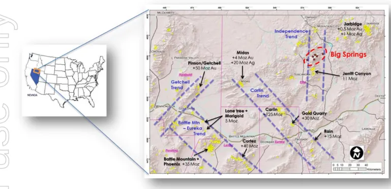
north eastern Nevada, USA (Figure 1).
The Inferred Mineral Resource estimate has been completed in
accordance with the JORC Code and comprises a total resource of
14.8 million tonnes at 2.0 g/t gold. Increasing the cut-off grade to 2.5
g/t gold results in a high grade core to the deposit of 2.9 million tonnes
of 4.2 g/t gold for 388,000 ounces.
Anova’s geological model was developed in-house and the resource
estimate was prepared by specialist consultants Trepanier Pty Ltd as
described within this announcement (Appendix 1). The Mineral
Resource estimate will be the basis for a gold production scoping
study to commence shortly.
“This maiden JORC Mineral Resource estimate confirms the size and
quality of our 100% owned Big Springs gold project,”
said Tim Dobson,
Managing Director.
“It paves the way for the assessment of both open cut and
underground mining options from surface in line with our intention to
bring this low risk project into gold production as soon as practicable.”
ASX ANNOUNCEMENT
ASX:AWV
Anova Metals LimitedABN 20 147 678 779
Directors
Jon Parker –Chairman & NED Tim Dobson – Managing Director Bill Fry – NED
Mal James – NED
Management
Tim Dobson – Managing Director Geoff Collis – GM Exploration Leni Stanley – Co. Secretary
For further information contact:
Tim Dobson Managing Director
[email protected] Tel: +61 8 9486 4326
Figure 1: Big Springs project location in Nevada, USA
Big Springs JORC (2012 edition) Mineral Resource estimate
Description of geology & mineralisation
The Big Springs disseminated, sediment-hosted gold deposits have been classified by
respected scientific authors as typical Carlin-style deposits. Gold is hosted predominantly
within the “Overlap Assemblage”, which is Mississippian to Permian in age (300 to 360Ma), with
structure and host stratigraphy being the primary controls on gold mineralisation.
Mineralisation is typically hosted within black, highly carbonaceous siltstone and calcareous
sandy siltstone. These units are typically located between the Argillic thrust in the footwall and
the Schoonover thrust in the hangingwall. Individual high grade ore shoots at North Sammy
generally plunge moderately to the NNW and are controlled by intersections of E-W-striking
faults with the NE-SW-striking Argillic thrust. The South Sammy Creek deposit is more complex
with a series of controlling structures, in particular the Briens fault along the western margin.
On the eastern side of the Briens fault the thick, tabular South Sammy ore deposit forms a
largely continuous zone that is semi-concordant with the permeable and brittle host rocks of
the Overlap Assemblage.
Data used in estimation process
All historic hardcopy and digital data was obtained from the project vendors and assimilated
into Anova databases. Useful information dates back to the mid-1970s when serious
exploration was first carried out in the Independence Mountains. Considerable hardcopy
data pertaining to the 1987 – 1993 Big Springs mining era have been catalogued, digitised
and returned to Australia for assessment. This data has been used to inform the resource
estimation process.
Historically, two main phases of drilling have occurred at Big Springs. Independence Mining, a
subsidiary of Freeport-McMoRan, conducted an extensive drilling campaign between 1982
and 1993 which ultimately resulted in the production of 386,000 ounces of gold from a series of
small open pits. Gateway Gold Corp, a TSX listed exploration company, later acquired the
property and conducted drilling between 2003 and 2008 predominantly aimed at verifying
and extending the mineralisation discovered and exploited by Freeport. A total of 2,410 drill
holes representing 289,000 metres of drilling were used for the interpretation.
Mineralised domain definition
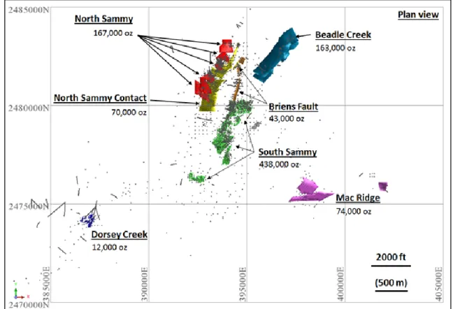
The Big Springs gold resource has been divided into three primary zones (North Sammy, South
Sammy and Beadles Creek) and four subsidiary zones (North Sammy Contact, Briens Fault,
Mac Ridge and Dorsey Creek) as shown in Figure 2. Mineralised shoots with well-defined
structural and lithological control, such as North Sammy and Beadles Creek, were individually
modelled using 3D wireframes. Deposits with more diffuse and poddy forms, such as South
Sammy, were estimated using indicator models.
Application of lower cut-off grades
A 1.0 g/t gold cut-off appears to be a natural grade boundary for the well-defined structurally
controlled shoots while a nominal 0.8 g/t gold cut-off was used for the more diffuse zones with
open pit potential. Samples were composited to 1.52 metre lengths. Statistical analysis
showed the populations in each domain to generally have acceptable levels of variation,
however each estimation domain contained outlier values that required top-cut values to be
applied.
Block model
A block model was created using Surpac software incorporating 3.05 x 3.05 x 1.52 metre
blocks, constrained by wireframes as described above. Directional variograms and Ordinary
Kriging were used to estimate grades in all domains, with estimation searches governed by
individual variograms for each domain. Historic bulk density measurements from the property
could not be verified and hence a nominal 2.60 g/cm
3was selected based on published data
available for similar rock types.
JORC classification
The mineralised domains have demonstrated sufficient continuity in both geological and
grade continuity to support the definition of Mineral Resource and Reserves, and the
classifications applied under the JORC Code (2012 edition). Consideration was given to
classifying sections of the deposit in the Indicated category, however the unverified bulk
density data ultimately resulted in the entire mineral resource being classified as Inferred.
No assumptions have been made as to mining methods other than both open pit and
underground operations will be considered. No assumptions have been made as to
metallurgical recoveries, environmental matters or infrastructure.
Mineral Resource estimate
Deposit Cut-off
(g/t Au)
Tonnes (Mt)
Grade (g/t Au)
Contained gold (‘000 ounces) North Sammy 1.0 1.3 4.0 167 North Sammy Contact 0.8 1.3 1.7 70 South Sammy 0.8 7.3 1.9 438 Beadle Creek 1.0 2.1 2.4 163 Mac Ridge 0.8 1.7 1.4 74 Dorsey Creek 0.8 0.3 1.4 12 Briens Fault 1.0 0.8 1.6 43
Total 14.8 2.0 968
Note: Appropriate rounding applied
Table 1: Big Springs Inferred Mineral Resource estimate (2012 JORC Code guidelines)
Figure 2: Plan projection of the Big Springs resource domains
Effect of varying cut-off grade
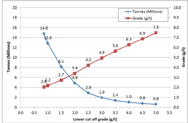
The Mineral Resource has been reported for a range of cut-off grades (Table 2) in order to
produce a grade vs. tonnage relationship (Figure 3). It can be seen, using a 2.5 g/t cut-off
grade, that a higher grade portion of the Resource exists with 40% of the overall contained
gold (388,000 ounces) contained within a 2.9 million tonne, 4.2 g/t resource.
Cut-off
(g/t Au) Tonnes (Mt) (g/t Au) Grade Contained gold (‘000 ounces) 0.861 14.8 2.0 968
1.0 12.8 2.2 900 1.5 8.2 2.7 712 2.0 4.9 3.4 530 2.5 2.9 4.2 388 3.0 1.9 4.9 306 3.5 1.4 5.6 249 4.0 1.0 6.3 207 4.5 0.8 6.9 176 5.0 0.6 7.5 149 Note: Appropriate rounding applied
Table 2: Big Springs Inferred Mineral Resource estimate at various cut-off grades
Figure 3: Big Springsgrade-tonnage relationship at various cut-off grades
1 Weighted average of domains estimated with 1.0 g/t and 0.8 g/t cut-off grades.
Future work
Anova is currently preparing and permitting a limited drilling program at Big Springs to confirm
a number of technical aspects of the deposits with a view to re-classifying the Mineral
Resource, supporting operational permitting requirements, and informing subsequent mining
studies. Both open cut and underground mining studies will be undertaken on the block
model to determine the optimal production scenario for the project. The size, shape and
depth (commencing at surface) of the Big Springs deposits indicate that a combination of the
two methods will be appropriate.
Big Springs project purchase terms triggered
In line with the Big Springs project purchase terms previously announced to the market (ASX
Announcement 28 November 2012), the JORC Mineral Resource estimation triggers the
conversion of 17 million Performance Shares held by the project vendors to Anova Ordinary
Shares, and a further cash payment, subject to review and approval of the JORC Mineral
Resource estimate by the vendors.
Competent Person Statement
The information in this report that relates to Exploration Results is based on information compiled by Mr. Geoff Collis, who is an employee of the Company. Mr Collis is a member of the Australasian Institute of Mining and Metallurgy and has sufficient experience of relevance to the styles of mineralisation and types of deposits under consideration, and to the activities undertaken to qualify as a Competent Person as defined in the 2012 Edition of the Joint Ore Reserves Committee (JORC) Australasian Code for Reporting of Exploration Results, Mineral Resources and Ore Reserves. Mr Collis consents to the inclusion in this report of the matters based on information in the form and context in which it appears.
The information in this report that relates to Mineral Resources is based on information compiled by Mr Lauritz Barnes, Principal Consultant Geologist – Trepanier Pty Ltd and Mr Geoff Collis, General Manager Exploration, an employee of the Company. Mr Barnes and Mr Collis are both shareholders of Anova Metals. Mr Barnes and Mr Collis are members of the Australasian Institute of Mining and Metallurgy and have sufficient experience of relevance to the styles of mineralisation and types of deposits under consideration, and to the activities undertaken to qualify as Competent Persons as defined in the 2012 Edition of the Joint Ore Reserves Committee (JORC) Australasian Code for Reporting of Exploration Results, Mineral Resources and Ore Reserves. Mr Barnes and Mr Collis consent to the inclusion in this report of the matters based on their information in the form and context in which they appear.
Appendix 1: JORC Code (2012) supporting tables.
The following section is provided to ensure compliance with the JORC (2012) requirements for
the reporting of the Mineral Resource estimates for the Big Springs gold deposit in Nevada.
Section 1: Sampling Techniques and Data
(Criteria in this section apply to all succeeding sections.)
Criteria Commentary
Sampling
techniques Samples were routinely collected at 5 foot (1.52m) intervals from Reverse Circulation (RC) and diamond drill holes (DDH). Freeport drilled 2098 holes between 1982 and 1993 primarily on a nominal 50ft by 50ft (15.2m) spacing, increasing to about 100ft (30.5m) by 50ft in places. Gateway Gold Corp (“Gateway”) drilled 312 holes between 2003 and 2008 as infill to these grids.
Gold occurs as very fine inclusions within finely disseminated sulphide mineralisation
resulting in a moderate nugget effect. The sampling intervals are considered sufficiently small to yield statistically valid results given the nature of mineralisation encountered. Based on statistical analysis of field duplicates, there is no evidence to suggest samples are not representative.
Sampling procedures followed by all historic operators were in line with industry
standards at the time (personal communication with senior staff and drilling companies in charge of previous work). All RC samples were split at the rig using either a riffle or cone splitter to produce between 3 and 5kg of sample for shipment to the laboratory. Diamond core was HQ size, and cut in half over mineralized intervals, using either a core-splitter or core-saw. All samples were analysed.
Drilling techniques Data from 2410 drill holes (289,000 metres) were used for the interpretation. Freeport drilled both RC and diamond core however the exact proportion of each has yet to be verified from the hardcopy logs. Gateway drilled 312 holes of which 141 were RC and 171 were HQ diamond core. The majority of the Freeport holes were drilled vertically while the more recent Gateway holes were inclined as in-fill or extension to the deposits.
Drill sample recovery
Core recovery data are available for 160 of the Gateway holes. Nearly 90% of these
data have recoveries above 80%. Core recovery is described as “good to excellent” by previous workers.
For the historic component of the database, it has not been possible to check sample
recoveries and sampling methods. However, for Gateway drill holes, recovery data has been recorded, and field duplicates submitted and analysed.
It was not possible, given the historical nature of the bulk of the database to make these
types of assessments. It is planned that future drilling will target these issues.
Logging Detailed lithological logs exist for most of the holes in the database. Where these only exist in hard copy, they have been scanned and stored digitally. It is planned that the additional information from these logs that is not currently in the digital database (minerals, geotechnical, structural data) will be collated and included for future resource estimation work.
Logging of diamond core and RC samples recorded lithology, mineralogy,
mineralisation, structure (DDH only), weathering and colour. Core photographs also exist for some of the Gateway holes.
Lithological data exists for 2149 of the 2410 holes in the database (90%). These drill holes
were logged in full.
Criteria Commentary Sub-sampling
techniques and sample
preparation
Diamond core was cut in half on site using a mechanical splitter or a diamond saw.
Some quarter core has been sampled to perform check assaying by previous workers.
RC samples were generally wet and split at the rig using a rotary device which was
standard industry practice in Nevada at the time.
Large samples weighing between 3 and 5kg each were dried, crushed and pulverized
using industry best practice at that time.
Field QC procedures for Gateway drill holes involve the use of certified reference
material assay standards and blanks; as well as rig, reject and assay duplicates.
For all Gateway drill holes, in the case of RC samples, rig duplicates were collected at
regular intervals. Diamond core was “duplicated” every 60 to 70 core samples by submitting the remaining half core for analysis. Personal communication with senior staff supervising the Freeport drilling indicates that industry best practice was employed at the time.
The sample sizes are considered appropriate for the style of mineralization, which is fine
grained disseminated gold with minimal nugget effect.
Quality of assay data and laboratory tests
Historical assaying was undertaken by one of the following; Monitor Geochemical
Laboratory, American Assay Laboratories, Chemex Laboratory or Cone Geochemical. Most of the samples were assayed for Au by Atomic Absorption Spectroscopy after roasting and acid digestion. Selected samples were analysed by Fire Assay, or by cyanide leach on either roasted or un-roasted pulps. These techniques are designed to report total gold. Gateway samples were submitted to ALS Chemex for Au by Fire Assay/atomic absorption (FA/AA). All samples in excess of 5g/t Au were re-assayed by Fire Assay with gravimetric finish (FA/Grav). In addition all samples were analysed for a suite of 34 elements with either an aqua regia or 4 acid digest and ICP/AES finish.
No geophysical tools were used to determine any element concentrations in this
resource estimate.
Hard copy logs of historical drilling show that umpire laboratory checks were
undertaken to check the Monitor Geochemical Laboratory results. The Gateway drilling contains QC samples including field duplicates, coarse crush laboratory duplicates and laboratory pulp splits, certified reference materials and blanks. Previous workers have verified historical assay data by re-assaying of Freeport diamond holes.
Verification of sampling and assaying
Independent consultant reports have been viewed that verify significant intersections in
diamond core.
Twinned holes have been drilled along with drill holes fanned about a central collar.
Visual inspections have been completed with original and twin holes showing comparable results but no detailed statistical analysis has been undertaken as yet.
Primary data was sourced from an existing digital database and compiled into an
industry standard drillhole database management software (DataShed™). Records have been made of all updates that have been made in cases of erroneous data. The database is in the process of being enhanced with additional data sourced from both digital and hard copy logs. Data verification has been ongoing with historical assays and surveys being checked back against hard copy logs. All Gateway assays were sourced directly from original electronic laboratory files.
No adjustments or calibrations were made to any assay data used in this estimate.
Location of data points
Collar surveys have been used from the supplied database. Where discrepancies
occurred, these coordinates were edited only after checking against hard copy logs. This process will continue as part of the database enrichment. Downhole survey records have been checked against digital and hardcopy survey logs and where necessary additional surveys have been added to the database. All edits have been
documented. All holes have been checked spatially in 3D and all obvious errors addressed.
The grid system uses the NAD 27 Datum, and the Nevada East State Plain projection in
feet.
The topographic surface was sourced from digitized scanned pit maps from mine
Criteria Commentary Data spacing
and distribution The nominal drillhole spacing is approximately 50ft by 50ft (15m), but this can increase in places. Gateway holes have been drilled as infill to these grids as confirmation of mineralisation.
The mineralized domains have demonstrated sufficient continuity in both geological
and grade continuity to support the definition of Mineral Resource and Reserves, and the classification applied under the 2012 JORC code.
No sample compositing has been applied.
Orientation of data in relation to geological structure
2125 out of 2412 holes were drilled vertically (88%). The remainder were drilled at angles
of between 850 and 300 and azimuths of between 00 and 3500. The orientation of the
mineralisation is variable and no bias has been detected.
No orientation based sampling has been identified to date.
Sample security Gateway samples are stored at the Doheny Ranch located east of the Big Springs property. All samples were sorted here before being sent by a dedicated truck to ALS Chemex in Elko. After analysis, all samples were returned and archived and coarse sample rejects discarded. Core is stored in wooden boxes and racked for reference, as are chip trays. There is no information regarding security of samples for work previous to Gateway’s tenure at the project.
Audits or reviews Gateway completed checks of historic assays with favourable comparisons. Anova has checked 5% of the collar and assay data in the supplied digital database against hard copy logs and found no material discrepancies.
Section 3: Estimation and Reporting of Mineral Resources
(Criteria listed in Section 1, also apply to this section.)
Criteria Commentary
Database integrity
Data have been compiled into a relational SQL database, the setup of this database
precludes the loading of data which do not meet the required validation protocols. The data are managed by DataShed™ Management Software, which also has inbuilt validation checks. Data have also been checked against original hard copies for 5% of the data, and where possible, loaded from original data sources.
Site visits Geoff Collis and Lauritz Barnes, who are the Competent Persons, both visited the Big Springs site on 7 November 2012. During the visit historical pits were inspected,
geological units within pits compared to mapped geology, grab samples were taken, photos were taken, diamond core was viewed, GPS checks were carried out on selected drillhole collar sites. ALS Global’s minerals laboratory in Elko, Nevada was visited and inspected (where the majority of Gateway’s samples were prepared and analysed between 2003 and 2008). Anova’s check grab samples were submitted for analysis with this laboratory.
Geological interpretation
The historical digital database used for the interpretation included logged intervals for
the key stratigraphic zones. Detailed geological logs were available in hardcopy and reviewed where necessary.
Litho-geochemistry for the Gateway holes assisted to confirm the validity of the historic
stratigraphic interpretation with good confidence.
Drill density (50ft by 50ft) for the majority of the Big Springs area allows for confident
interpretation of the geology and mineralized domains. More recent infill/verification drilling by Gateway confirms positions of key mineralized zones. Geological and structural controls support modeled mineralized zones.
Continuity of mineralization is affected by proximity to structural conduits (allowing flow
of mineralized fluids), stratigraphic position, lithochemistry of key stratigraphic units and porosity of host lithologies.
All remaining mineralisation is considered to be transitional to fresh material as the vast
majority of oxide ore has been mined previously.
Criteria Commentary
Dimensions The Mineral Resource areas vary however mineralized zones modeled have dimensions
of up to 4,000ft (north) by 1,000ft (east) and 1,000ft (elevation) for North Sammy, South Sammy and Beadle Creek. The other zones are smaller than these.
Estimation and modelling techniques
Grade estimation using Ordinary Kriging (OK) was completed using Gemcom Surpac™
software for gold only. Drill spacing typically ranges from 50ft (15.2m) to 100ft (30.5m).
Drillhole samples were flagged with wireframed domain codes. Sample data was
composited for gold to 5ft using a best fit method. The very minor number of residuals were considered immaterial and were excluded.
Influences of extreme sample distribution outliers were reduced by top-cutting on a
domain basis. Top-cuts were decided by using a combination of methods including grade histograms, log probability plots and statistical tools.
Directional variograms were modeled by domain using traditional variograms and
correlograms. Nugget values are moderate and grade ranges generally short
(approximately 50-60m). Domains with limited samples used variography of geologically similar domains.
Previous open pit mining activity produced approximately 380,000 oz of gold. Historical
pit shapes and mined zones match mineralized zones (modeled using drilling data) well. No underground mining has been conducted at Big Springs. A published 2006 NI 43-101 resource is available on SEDAR.
No by-products have historically been produced, or are expected to be produced,
from Big Springs.
No other elements are estimated to date due to the limited availability of multi-element
assays – this exists for the more recent Gateway drilling only.
Block model was constructed with parent blocks of 10ft (E) by 10ft (N) by 5ft (RL) and
sub-blocked to 5ft (E) by 5ft (N) by 2.5ft (RL). All estimation was completed to the parent cell size. Discretisation was set to 5 by 5 by 2 for all domains.
Three estimation passes were used. The first pass had a limit of 125ft (38.1m), the second
pass 250ft (76.2m) and the third pass searching a large distance to fill and blocks within the wireframed zones. Reporting was limited to Passes 1 and 2. Each pass used a maximum of 24 samples, a minimum of 8 samples and maximum per hole of 5 samples.
Search ellipse sizes were based primarily on a combination of the variography and the
trends of the wireframed mineralized zones. Hard boundaries were applied between all estimation domains.
Validation of the block model included a volumetric comparison of the resource
wireframes to the block model volumes. Validation of the grade estimate included comparison of block model grades to the declustered input composite grades plus swath plot comparison by easting, northing and elevation. Visual comparisons of input composite grades vs. block model grades were also completed.
Moisture Tonnes have been estimated on a dry basis.
Cut-off
parameters
Zones more likely to be mined by underground methods (primarily at North Sammy and Beadle Creek) have been wireframed to a 1.0g/t gold off. For these shoots, this cut-off also tends to be very close to a natural cut-cut-off. All other zones have been reported inside the mineralisation wireframes constructed at an approximately 0.8g/t gold cut-off, either by wireframing or indicator modeling methods.
Mining factors or assumptions
The only assumptions made as to mining methods are that both open pit and
underground operations will be considered. Factors such as a successful previous mining history, open pits still with stable walls after 20 years since the mine closure, successful historical processing of both oxide and sulphide ore plus numerous nearby mining operations on similar styles of mineralization and processing facilities indicate that the assumption for potential successful mining of Big Springs is reasonable.
Metallurgical
factors or A combination of a historical period of processing both oxide and sulphide ore from Big Springs plus more recent limited metallurgical testwork by Gateway indicate that the
Criteria Commentary Environmental
factors or assumptions
No assumptions have been made and these will form part of any future studies.
Preliminary discussions have been held with the relevant permitting agencies and the regulatory process determined.
Bulk density Bulk density has previously been estimated from measurements carried out by Gateway drilling on 98 core samples using weight in air and weight in water. Samples were tested from different rock types, as well as within mineralized zones (Gateway reported 61 to be from within mineralized intervals). Sample masses varied from 150 to 1200 grams (averaging 450 grams). It was found that there was low variability in density values between the categories and the previous NI 43-101 resource was reported using a bulk density of 2.75.
Concern that the method used by Gateway (weight in air and weight in water) does
not adequately account for potential porosity has resulted in a more conservative bulk density of 2.60 being used for this resource. The number is based on a review of bulk densities for similar rock types and allowing for decrease from the previously used bulk density due to porosity.
Classification The Mineral Resource has been classified on the basis of confidence in the geological model, continuity of mineralized zones, drilling density, confidence in the underlying database and the available bulk density information.
All factors considered with the exception of bulk density, Indicated classification would
be highly likely for a significant portion of the resource. However, the unverified bulk density resulted in the CP’s classifying the entire resource as Inferred.
Audits or reviews No independent third party review has been conducted.
Discussion of relative accuracy/ confidence
The relative accuracy of the Mineral Resource estimate is reflected in the reporting of
the Mineral Resource as per the guidelines of the 2012 JORC Code.
The statement relates to global estimates of tonnes and grade.
Available hardcopy production data has briefly been reviewed. Further analysis of the
information will be completed during the next phase of resource work.