Reinforcing Our Relevancy in a Local Context
Case Studies from North Carolina Chapter
of the American Planning Association Contributors
Judy Francis
Glenn Simmons
Corey Liles
Lori Quinn and Bryman Suttle
Editors’ Note:
Carolina Planning
regularly publishes a feature highlighting projects from members of the
North Carolina Chapter of the American Planning Association (NCAPA). This year’s submissions focus
on initiatives that are reinforcing the relevancy of planning in various North Carolina communities. From
case studies discussing the role of robust plans in shaping the future of a community to articles highlighting
the importance of using data to help inform planning activities and funding, these writers provide valuable
insights into the important role North Carolina planners play in shaping the futures of their communities.
Judy Francis, AICP, is the Western Programs Coordinator for the N.C. Department of Environment and Natural Resources Office of Conservation Planning & Community Affairs. She serves as the Executive Secretary for the N.C. Mountain Resources Commission and is based in Asheville, NC.
Glenn Simmons, RLA, AICP, is a Registered Landscape Architect and Principal Planner with the joint Winston-Salem and Forsyth County Planning Department. Currently he heads the Comprehensive Planning and Implementation section of the City-County Planning Department.
Corey Liles serves as Planner for the Research Triangle Foundation of North Carolina, manager and developer of the Research Triangle Park. He provides technical input and other support for land-use and infrastructure projects in RTP, including the new Master Plan.
Lori Quinn works as a Planning Coordinator for the Charlotte-Mecklenburg Planning Department. She earned her Master of Arts in Geography from the University of North Carolina at Charlotte and has experience applying GIS in land development analysis, environmental analysis and database design.
Bryman Suttle works for the Charlotte-Mecklenburg Planning Department. He has over 10 years of experience as a community planner.
As one of the fastest growing states in the country, North Carolina needs visionary planning now more than ever. The NCAPA-contributed articles in this feature highlight various tools and approaches that reinforce the importance of the planning profession in guiding the state’s future. Below is an overview of the pieces:
Western North Carolina Vitality Index
Judy Francis discusses the Western North Carolina Vitality Index, a product of the Mountain Resources Commission, and the need for comprehensive and publicly available environmental, economic, and cultural data. The new web-based decision support tool is designed to inform and encourage regional decision making with an emphasis on quantitative metrics that measure sustainability. Francis highlights the importance of this tool in combining various data sources and indicators that are related to sustainability and are relevant to the entire Western region of North Carolina.
Comprehensive Plans and Key Public Investments: Promoting Land Uses that Generate Positive Fiscal Impacts
Carolina Planning Volume 37
The Quilt Trails of Western N.C. Initiative is an example of
place-based economic development. It capitalizes on specific
natural and cultural assets that can’t be outsourced beyond the region. Image courtesy of Barbara Webster.
Simmons recommends that planners consider the tax base, sustainable land use, and public investment implications of higher density versus low density development. The article emphasizes the opportunity for planners to use comprehensive plans to targete public investments specifically to spur private investment.
Positioning Research Triangle Park for Continued Prosperity
Corey Liles confers the major features of the new Research Triangle Park (RTP) Master Plan. The plan recognizes the need to capitalize on partnerships and promote clustered, mixed use development in order for RTP to remain competitive with other global innovation centers. Liles highlights the importance of responding to the needs of the businesses it is trying to attract while also building RTP’s community brand. The article also highlights the history of the development of RTP, the role that partnerships played in its creation, and the importance of partnerships in building its future.
Area Plan Implementation Program: From Paper to Progress
Lori Quinn highlights Charlotte’s Area Plan Implementation Program, a planning and database initiative that inventories, analyzes, tracks funding, and documents recommendations from a variety of adopted city plans. The program empowers planners to work with the community to produce and deliver on plans with a realistic opportunity of implementation. Quinn highlights the usefulness of the database in understanding costs associated with recommendations and encouraging collaboration between the Planning Department and other city business functions.
Creating a Place-Based Vitality
Index for Western North Carolina
Judy Francis
Most planners working in the Western region of North Carolina are well aware that the region’s environment, economy, and cultural traditions are inextricably bound together from both historical and contemporary perspectives. Extraordinary mountain landscapes and globally-significant levels of biodiversity inspire entrepreneurial energy that manifests as exquisite art, enchanting music, and place-based industries that provide thousands of jobs and pump millions of dollars into the regional economy. Nurturing the region’s strengths and assets over time depends on our ability to see the connections between these diverse local assets and chart a future that is a sustainable response to the possibilities and limitations of this particular place. To this effect, the Western North Carolina Vitality Index (WNC Vitality Index), funded by the Mountain Resources
Commission (MRC), is a new web-based decision support tool recently developed to inform decision-makers and the general public about sustainability issues in the western 27 counties.
Regional projects require broad-based participation from both public and private entities that are able to come together in a forum that is conducive to honest communication and reliable technical data. In 2009, the General Assembly adopted legislation that created the MRC, a group with a legislative charge to coordinate with local and regional partners and provide advisory recommendations and educational tools to protect and enhance the region’s place-based assets. During the initial strategic planning work session held soon after the establishment of the MRC, the members adopted the following mission statement: “The mission of the North Carolina [MRC] is to take care of our natural resources to enhance and sustain quality of life and ensure the long-term health of our region and our people.” The members also discussed the need to encourage a vision of sustainability that would encompass all 27 counties in the western region by illustrating the connections that exist between its natural, cultural, and economic conditions and examining the viability of each as a relationship to the other.
through grant awards and program funds.
The U.S. Forest Service developed a wonderful hard copy and web-based product, the Western North Carolina Report Card on Forest Sustainability, which focuses on the connections between the future of forestry and other sustainability metrics for the region1. The Report Card
begins to address the need for a regional examination of sustainability, however only covers 17 counties and is focused on a particular resource topic area. The U.S. Forest Service contracted with Jim Fox at the National Environmental Modeling and Analysis Center (NEMAC) at the University of North Carolina-Asheville to assist with the development of the Report Card. Mr. Fox, a technical advisor to the MRC, provided them with some options of how the Report Card could be expanded to cover the entire western region and include additional sustainability metrics. With financial assistance from the U.S. Forest Service and the Blue Ridge National Heritage Area, the MRC developed the Vitality Index, which is a greatly expanded version of the original forestry report card.
The WNC Vitality Index covers a total of 27 counties and incorporate a much broader set of over 100 different metrics to measure regional sustainability. The MRC’s technical council met for over a year to discuss what metrics were most useful, and what specific data was available to cover all 27 counties so a true regional picture could be developed. The natural environment is described with data sets including issues such as various natural heritage characteristics, biodiversity indices, land cover and natural area fragmentation, aquatic and atmospheric classifications, and wildlife habitat. Economic data concerning job creation and employment numbers,
businesses are included with the assistance of Dr. Todd Cherry from Appalachian State University. Dr. Cherry collected economic data for years and compiled it in the monthly WNC Economic Index, which is used by many industries and entrepreneurial programs to gauge regional economic health. The economic impacts of agriculture are also included, as is a comprehensive data set concerning soil types and water availability. Additional metrics illustrate the benefits of tourism and historic crafts to the region. Other issues represented in the index are population demographics such as education levels, mobility, incidence of disease, access to health care, data concerning aging and other population demographics, and other health and wellness indicators.
Data sets were selected based on a number of characteristics including level of comprehensiveness, ability to be depicted spatially, and filling information gaps about traditionally underrepresented sectors. Additionally, specific narratives based on actual examples and experiences were incorporated to illustrate the relevance of various types of information and how they relate to each other. Users create their own maps using the tool, and since the web-based format can be easily and cost-effectively updated, the public will always have fresh and reliable information available at no cost.
The tool will also assist regional planning efforts by providing data in a regional context as opposed to traditional data silos. Users will be able to compare metrics at the regional, county, and local levels and see trends illustrated graphically. Many metrics give information about how the western region compares to national and state averages. The results have certainly indicated that problems may WNC Vitality Index Mapping. An example of the web-based mapping tool for the Vitality
Carolina Planning Volume 37
would in other parts of the state due to differences in infrastructure capacity, income shortfalls, and geographic limitations. The data is already being used by planners at Land of Sky Regional Council of Governments as part of their Sustainable Communities Initiative.
Western North Carolina is a prime example of a place-based economy. It has a culture that is uniquely driven by its landscape and a locally-driven market that relies heavily on its natural and cultural assets. A well-planned and deliberate approach to sustainability for this region will be dependent on the long-range vision and creative entrepreneurship of its residents, decision-makers, and technical staff, such as the local and regional planners that serve them. Their fate is entwined with that of this land, and rests entirely on their ability to base decisions on what is best and fair for both the land and its people— the WNC Vitality Index can assist with developing this deeper understanding of the complexities and relationships between these different players and the land they live. Try out the WNC Vitality Index here:
http://dev.nemac.org/mrc/ecosystems/biodiversity
To learn more about the N.C. Mountain Resources visit: http://www.onencnaturally.org/pages/CO_Mountain_ Resources_Commission.html
Endnotes
1 http://nemac.unca.edu/wnc-report-card
Comprehensive Plans and Key
Public Investments: Promoting
Land Uses that Generate Positive
Fiscal Impacts
Glenn Simmons
Comprehensive planning is about making a community a better place to live, work, and play. Comprehensive plans usually include public investment strategies for future economic growth and vitality; however, many lack an acknowledgement of the current and future fiscal implications of dispersed versus more compact development patterns. Some public investment strategies are more effective than others at growing the tax base and promoting fiscally sustainable land uses. These strategies, which take into account the fiscal implications of development, are especially critical and relevant given the lingering effects of the Great Recession and dramatically reduced public resources.
In Winston-Salem and Forsyth County, a process is underway to update the county’s comprehensive plan.
The City-County Planning staff is critically evaluating various demographic and development trends and making recommendations to maximize the investment benefits of valuable public resources. In other words, public investments that generate net income greater than the costs of service delivery should have priority consideration by governing bodies. Particularly during the current economic climate, the ability to identify and target scarce discretionary funds to stimulate sustainable economic growth and promote quality of life is a most important strategy.
Background
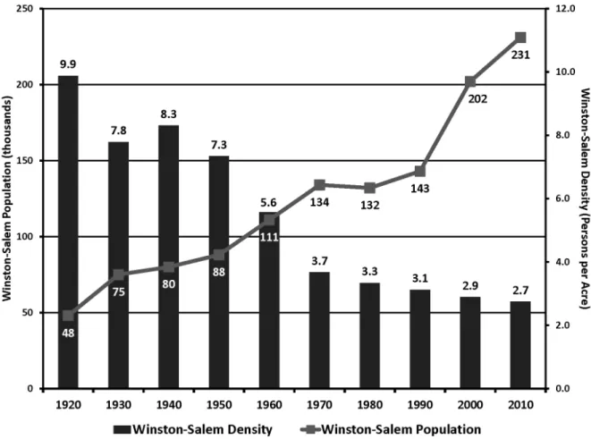
Like many of North Carolina’s urban counties, Forsyth County’s overall population grew between 1980 and 2010, while municipal population densities decreased (see Figure 1). Over that same time period, suburban growth in Winston-Salem consumed land at one and a half times the growth of its population while congestion rose and estimated vehicle miles traveled more than tripled. These trends are the result of decades of public policies and market forces, which accelerated suburban growth and subsequent municipal annexations in Winston-Salem.
Most suburban infrastructure is built and paid for by private developers. However once dedicated, it becomes the public’s obligation to “take care” of the extra miles of ageing roadways, utility lines, and widely dispersed facilities. Even less obvious are the increasing costs associated with the wear and tear on service vehicles, the time public servants must spend simply moving from one job site to another, and the price of fuel and petroleum-related materials.
While most governmental budgets and capital improvement plans reference comprehensive plan recommendations as a way to prioritize public revenue allocations, in actuality, most revenues in current year operating budgets are already encumbered for the operation and maintenance of existing services, programs, and facilities. Where limited discretionary funds are available, it is increasingly important that municipalities not only evaluate the direct benefits of a particular capital project, but also the project’s capacity to spur additional private investments in priority land uses which are more economically sustainable over a longer period of time. Running Out of Land
time period, the state demographer projects that Forsyth County will grow by an additional 120,000 people despite the recent development slow down. To accommodate this population growth, more sustainable growth management strategies will have to be pursued.
Promote Fiscally Efficient Land Uses
It is no secret that on a per acre basis denser development yields a higher tax base than comparable, but more sparsely developed growth patterns. For example, one 145 unit residential apartment building in downtown Winston-Salem yields $269,000 per acre in tax revenue compared to the same number of moderately priced single family residential homes which yield approximately $6,000 per acre. Even higher-end residential subdivisions yield only about $18,000 of tax revenue per acre. Mixed-use residential, office and commercial developments in an urban setting generate a much greater per acre tax revenues with minimal additional public infrastructure costs.
Planners advocated compact growth for years, but in busier economic times such considerations were paid little heed as land availability, low energy costs, private lending practices, and consumer preferences perpetuated suburban growth in accordance with established public policy and practices. Just as compact
development tends to do a better job of generating greater tax revenues, it also tends to be more efficient and less costly to serve with municipal services. It costs the city $100,000 to resurface a mile of two lane streets regardless of whether it serves fifty residences of five hundred.
Recognizing both the fiscal synergies of more compact growth and Forsyth County’s desire to attract a knowledge-based workforce, the draft Comprehensive Plan Update recommends that the elected bodies target some portion of the annual budget toward that key objective. By intentionally committing public resources for urban amenities such as sidewalks, street trees, parks and other pedestrian elements at designated activity centers and downtown locations, in addition to other economic development incentives, the City can catalyze private investment. Cities like Greenville, South Carolina, and more recently Chattanooga, Tennessee, benefitted tremendously from such public investment initiatives as they reinvented their communities’ urban character and improved their economic attractiveness.
Public Investments to Spur Private Investment
Many communities advertise their willingness to partner with companies to entice new jobs and capital investments in downtown areas. By making specific
Carolina Planning Volume 37
non-residential development that is limited to research, development, and high technology manufacturing. As a planned effort run by the non-profit entity, the Research Triangle Foundation of North Carolina (RTF), RTP has a unique location with its connection to three research universities—Duke University, North Carolina State University, and UNC-Chapel Hill. Thanks to strong leadership coordinated among the public and private sectors, RTP stands today as the largest science park in North America and one of the most significant employment centers in the state. Its creation produced ripple effects across the state economy, creating greater prosperity for North Carolinians. This legacy of success now serves as the cornerstone for the next major planning effort in RTP: envisioning a new Master Plan.
The Master Plan, an effort of RTF, comes in response to the new circumstances. For the last fifty years, RTP grew and thrived by recruiting large corporations who occupied separate research campuses; however, current market trends suggest a new model is needed for the Park. Trends in entrepreneurship create momentum for start-ups, university spin-offs, and other smaller ventures. Rather than buying land, these businesses tend to prefer leasing space in walkable, mixed-use environments. Greater concentration of activity encourages collaboration while providing on-site amenities to the next generation of knowledge workers. Unfortunately, RTP currently lacks these spaces and amenities—putting it at a disadvantage against the newest wave of research parks. Furthermore, the Park faces competition from established technology regions such as Boston and Silicon Valley, along with emerging clusters worldwide. Many other regions offer firms more incubator space, better access to venture capital, and, in the case of some international research parks, lower costs. The competition is intensifying, and so RTP must now work to remain cutting-edge.
The new RTP Master Plan promises to attract a broader range of companies while retaining and growing existing businesses. With these goals in mind, several main principles emerged in the planning process: clustered development that offers a variety of research facilities; vibrant, mixed-use research centers that foster innovation and promote social interaction; increased development capacity for established campuses; and more clearly defined roadway entrances into RTP. At the same time, there is a focus on sustainability, including the restoration of natural systems and attractive, shared open space.
So how will RTP accomplish the objectives outlined in the Master Plan? As the original landowner of RTP, the Research Triangle Foundation is able to exert some control over development through real estate transactions. Over time, the Foundation cultivated a strong set of companies that are invested “citizens” of the Park, each with a deeply rooted presence. These include large corporations like IBM, the U.S. EPA and other federal agencies, and scientific institutions such as the N.C. Biotechnology Center. With about 10% of the land remaining under its control, the recommendations for urban investment and emphasizing
collaboration with companies as a strategic part of its comprehensive plan, Winston-Salem and Forsyth County can signal its intention to become more urban to both private developers and the “creative class”. Fortunately, these types of improvements tend to be less costly, and potentially more efficient in incentivizing new private investment than some other forms of economic development initiatives. For example, $2 million of pedestrian improvements in downtown Winston-Salem in the early 2000s, helped incentivize $100 million in private investments in new downtown housing, a 51% increase in restaurants and pubs and a 113% increase in retail shops over the following six years.
Conclusion
By highlighting the fiscal benefits of key public investments in the urban form, Winston-Salem and Forsyth County’s update of their comprehensive plan benefits from the experiences of other growing southern metropolitan regions and embraces economic opportunities afforded by national and local trends. In addition to promoting transportation options and cultural vibrancy, targeted investments in the urban form can grow the overall tax base as it simultaneously reduces the need to spend valuable public resources on less sustainable land uses. Good planning translates directly to a community’s fiscal “bottom line”, works to support the service needs of the entire community, and thus signifies the relevancy of the planning profession especially during tight economic times.
Positioning Research Triangle
Park for Continued Prosperity
Corey Liles
Home to over 170 companies and 39,000 knowledge workers, the Research Triangle Park (RTP) is known globally as a center of ground-breaking innovation and discovery. But building a research cluster from scratch demanded careful collaboration and foresight from leaders in government, business, and academia. In the late 1950’s, with a state economy that relied heavily on agriculture, tobacco, furniture, and textiles, North Carolina leaders saw the pressing need for new opportunities in innovation industries. The key ingredients were already present in the Triangle: cheap land, research conducted at nationally recognized universities, and an educated labor pool. RTP thus became an early national example of a planned science park. The future of RTP requires this same careful collaboration and planning to ensure its continued success in a changing market.
Foundation still has the opportunity to be strategic about what facilities they attract to the Park and who will build that space.
Another way the Foundation will work to achieve these objectives is through branding. For the first several decades, RTP stood alone in the hinterlands between Durham and Raleigh. But growth slowly extended to the Park’s doorstep. Today, the surrounding office and industrial buildings ‘blur the edges’ of RTP, diluting the strength of a Park address. The Master Plan expands on prior efforts to define boundaries—taking signage, landscaping, and other aesthetics to the next level. The proposed mixed-use center and other signature destinations are intended to promote a strong sense of place. Having a community brand is valuable anywhere you go, but in RTP’s case it makes an enormous difference in attracting new companies and maintaining existing ones.
For the Master Plan to succeed, it is crucial to remember that relationships and collaboration contributed to the original success of RTP. The Park’s founders developed the vision of RTP’s future in conjunction with leadership in government, academia, and business. Through this collaboration, they gained not just supporters, but advocates dedicated to making North Carolina a better, more dynamic place. A statewide network of contributors raised the initial capital for the Park in less than three months during the fall of 1958. The Foundation also enlisted university professors to make recruiting visits to research companies. People connected with people to make the RTP vision a reality. Later, in the 1970’s, the Foundation sought to underscore RTP’s relationship with the three flagship universities by establishing a 100-acre joint campus for scholarly collaboration.
These collaborations were not just institutional, but intellectual as well. Partnerships led to innovative ideas and practices in the development of RTP, such as the incorporation of green building design. This same intellectual collaboration will be important in developing the Master Plan, especially when brainstorming new and creative programming opportunities for cluster development and a mixed-use center. The Foundation also seeks to partner with companies by developing infrastructure and amenities that serve the companies that move into the Park. The effective integration of land use planning and economic development enables the Foundation to know its customer and to plan for their needs. This point is crucial when considering that the Master Plan encompasses not just urban form and design, but programming elements. Beyond cafes and hotels, RTP companies cite the need for more incubator space and better access to capital. The Foundation does not provide all of these amenities directly, but can instead leverage the strengths of RTP companies and tap into some of the groundwork that is already being laid. For example, universities are seeking out opportunities for campus extensions and on-site programs. RTP can respond to this need by attracting and partnering with organizations such as The Contemporary Science Center which hopes
to establish a STEM (Science, Technology, Engineering, and Math) high school in RTP. Partnering with carefully selected institutions will ensure the Master Plan’s success by bringing in the right functions for the right space.
These are a few broad brushstrokes that hopefully give a sense of the history and future of Research Triangle Park. Several key lessons emerge from studying RTP’s history. First and foremost, is the lesson that strong relationships can often surpass regulations in producing desirable outcomes. Second, land ownership can be an effective component of the planner’s toolbox. Third, building public amenities should be driven by the goal of building a community brand. All of these lessons will be considered as implementation of the Master Plan gets underway. It is designed to be an evolving document that offers guidance for business strategy and financial planning, in addition to land use recommendations. The Research Triangle Foundation is charged with attracting new industries and jobs, not just to RTP but to North Carolina. This mission distinguishes it from a municipality or a typical developer, and the new Master Plan is unique as a result. But keeping that focus on the core mission, and outlining the steps needed to follow it, is a principle any planner can follow. In the end, this focus may offer the greatest opportunity to have an impact.
Area Plan Implementation
Program:
From Paper to
Progress
Lori Quinn and Bryman Suttle
The Charlotte-Mecklenburg Planning Department is a joint City/County Planning Department that advises the City Council and Board of County Commissioners on land use, design plans, zoning, land development, transportation/ transit, economic development, public facilities, and other general planning matters. Through public processes over the years, the Department had amassed dozens of adopted small area plans and hundreds of plan recommendations by 2005, but lacked funding and a comprehensive means to achieve implementation on the ground. Planning Director Debra Campbell asked the philosophical question; “Why is an Area Plan done, if we cannot implement it?”
Carolina Planning Volume 37
Database example. Planners use the database to quickly identify projects geospatially and by project type. Although a short project
description is included, this table provides the ID and page number giving the specific location for where that particular recom -mendation can be found in the plan. The planner can now retrieve additional context if necessary as well as identify any overlap of other City projects.
plans, and has tracked the implementation of an array of recommendations from various departments.
Funding
Without specific funds for the implementation of some of the area plans, the documents struggled to remain relevant. Therefore, one of the program’s first objectives was to demonstrate a financial need to attract financial commitment from Council. The Plan Implementation Team began work with the 2006 Transportation Bond on the horizon. The Planning Department presented a set of the comprehensive matrices along with supporting maps to the Budget Department for consideration for upcoming bonds.
The program was accepted for Bond participation and voters eventually approved the bonds in 2006, 2008 and 2010; providing $2.5 million per year for area plan implementation projects. The Planning Department thereby positioned itself as a recipient of neighborhood bond funding, which would go towards directly implementing capital projects envisioned during the area plan process. Using these funds, the Planning Department now manages its own capital investment program to construct and initiate capital improvement projects. Historically, the City’s Engineering department managed the funds appropriated for implementation projects. Often, monies earmarked for implementing recommendations were insignificant and not enough to focus on the needs identified in the adopted plans. Projects implemented were a small fraction of those included in the area plan.
The program resulted in a more seamless flow from Paper to Progress, and more direct visibility of results in
the eyes of the community, than previously existed. To date, several ambitious capital improvement projects have been constructed or initiated in fulfillment of Area Plan recommendations. Starting this project with no legacy database or process allowed the team to be open to many technological options but it also required the creation of clear and attainable goals.
Process
In setting up the program, the Plan Implementation Team defined a scope and work flow to gather the details needed to support the effort. Below are the general steps, in order, to getting our projects into a geospatial database. :
1. Interpret and document area plan recommendations 2. Design a database structured to provide answers to
questions posed by citizens and elected officials 3. Design symbology and standard mapping practices
for simple interpretation of data
4. Establish how queries and analysis would be reported. The Plan Implementation Team created an Excel database documenting thirty Area Plans from which hundreds of recommendations were extracted. These included hard recommendations, such as sidewalks, corrective rezonings, and pedestrian scale lighting, as well as soft ones like community safety, increased home ownership, and creation of neighborhood organizations.
The recommendations were organized and presented in a matrix format and then mapped in GIS. The geodatabase included specific attributes to allow staff to
Id Date/PageAdopted CategoryProgram Project Type Project Name Project Description (IAI)
eastb001 06-02 / 32 Infrastructure Planning Analysis/Study
Conduct an engineering study to explore poten-tial roadway and pedestrian improvements to East Boulevard, such as PED refuges, bulb outs, signalized crossings, planted medians and bicycle accommodations
eastb002 06-02 / 32 Infrastructure Vehicular Street Abandon the right-turn channel lane at Dilworth Road West and East Boulevard and convert to an area for public and pedestrian use only.
eastb003 06-02 / 33 Infrastructure Safety Bulb Out
Install bulb outs at intersections in the PED area where on-street parking exists and where there is adequate roadway width to provide this extension of the curb area.
query and categorize the vast array of recommendations. The attributes included in the database were based on common requests for data and reports staff received from both public officials and citizens such as funding source, lead agency and leverage opportunities to name a few. To aid with tabular analysis, all projects were placed into predefined project categories, types, and names. For example, the broad category might be “Infrastructure,” the project type might be “Vehicular,” and the project name might further describe the project to be a particular “Street Name.” All project recommendations were also assigned specific symbology to allow users to visually comprehend the nature of any particular plan recommendation.
The end products now reside within the Implementation chapters of adopted area plans, utilizing the established matrix format and geodatabase created during this initiative.
Examples of the completed projects include a sidewalk connecting a local elementary school to a neighborhood and a greenway connection to the local residences. Two streetscape projects have been recently implemented; they incorporate a road diet, consequently improving traffic flow and, reducing the number of through traffic lanes allowing for bike lanes, turn lanes with landscaped medians, and enhanced pedestrian crossings.
Lessons from the Development of the Database Development:
1. Innovation: The Plan Implementation Program team took advantage of technology to create a centralized cataloging of area plan recommendations, designed for accurate analysis, project selection, and cost estimation. This cataloging system allowed staff to identify projects for capital funding in less time and with more specificity than could be accomplished previously.
2. Collaboration: The database supports collaboration efforts between City and/or County departments by identifying geographically similar projects and initiatives that other departments may be considering. Staff are able to access and utilize this data when presented with proposals from the private development community—by leveraging funds from private development, or other capital and neighborhood programs, it extends the City’s resources allowing for more projects to be implemented than originally projected.
3. Data consistency: The data needs to be consistent across plans. Having too many caveats or exceptions hinder analysis. Indexing plan recommendations and digitizing individual items allows the department to conduct cost estimation, which helps determine capital project funding. Without data standards, your analysis will be limited.
4. Funding: As a result of the Plan Implementation Program, the Planning Department is able to track funding to determine where monies are being directed. In utilizing GIS, staff can locate and determine needs based on attributes and geography. Tracking of past expenditures, while understanding future project needs, has been useful as well in determining budgetary requirements of proposed projects. Staff is also able to provide up–to-date data of funded projects to citizens as well as City Council and County Commission concerning the level of expenditure in any geography.
Conclusion
In documenting all the previous implementation items from plans, the Planning Department recognized the need to create more defined projects in future area plans; one that empowers planners to work with the community to develop a realistic opportunity for implementation. Now, with a better understanding of the costs association with area plan recommendations future area plans now organize the recommendations according to importance to the community’s vision. This program further encourages collaboration between Planning and other City business functions for a more comprehensive implementation plan.
Carolina Planning Volume 37
2012 NCAPA Conference
“Re-Imagine Planning: Regional Thinking, Local
Placemaking”
September 26 - 28, 2012
Wilmington Convention Center
Wilmington, NC
Explore the issues discussed here – and more – at the annual gathering of the state APA
chapter. Visit the
Carolina Planning
exhibit table, attend our panel discussion on this
issue, and choose from numerous other panels, gatherings, and mobile sessions.
Save the date!
For more information, visit
http://www.nc-apa.org
.
through to implementation rather than solely depending on other city and/or county departments to fill this role. The Department also has a seat at the table for collaboration with other departments and government agencies to align capital resources on joint projects. The Plan Implementation Program has improved the Planning Department’s credibility, raised community expectations and involvement, enhanced citizen participation in the area plan process, and provided a great sense of accomplishment for our area planners in seeing a community’s vision implemented.
The authors would like to acknowledge the following members of the Charlotte-Mecklenburg Planning Department for their contributions to this piece:
• Alberto Gonzalez, Principal Planner • Martha “Gay” Grayson, Principal Planner • Garet Johnson, Assistant Director
• Kent Main, Planning Coordinator