423
THE USE OF THE GEOGRAPHIC INFORMATION SYSTEMS FOR
INVENTORING AND MONITORING THE GREEN AREAS IN
CARANSEBEȘ
TENCHE-CONSTANTINESCU ALINA-MARIA 1 HERBEI MIHAI 2 BORLEA GHEORGHE FLORIAN 3 1 Banat’s University of Agricultural Sciences and Veterinary Medicine „King Michael I of Romania” from Timisoara, Faculty of Horticulture and Forestry, Department of Horticulture, [email protected] 2 Banat’s University of Agricultural Sciences and Veterinary Medicine „King Michael I of Romania” from Timisoara, Faculty of Agriculture, Department of Sustainable Development and Environmental Engineering, [email protected] 3 Banat’s University of Agricultural Sciences and Veterinary Medicine „King Michael I of Romania” from Timisoara, Faculty of Agriculture, Department of Sustainable Development and Environmental Engineering, [email protected]
*Corresponding author email: [email protected]
Keywords: GIS, spatial analyses, databases, Caransebeş, Green cadaster
ABSTRACT
The purpose of this paper is to present a modern approach used to establish the Local Registry of Green Cadastre of the public administrative territory of Caransebeş Municipality. Topographic measurements of green areas and the tree inventory database have been performed with the latest generation GIS and GNSS instruments. More than 7,000 trees were identified taxonomically and their geographical coordinates and biometric data were determined. All the field data was loaded into an updatable database and processed using the ArcGIS v.10.3 software. A GIS map with all the Green Cadastre information was realized as a useful instrument for the Municipality in order to easily monitor and permanently have an actual image of their green areas situation. Additionally, 48 hectares of green areas have been identified and measured as future potential objects for new projects to be financed in order to improve their citizen’s welfare.
INTRODUCTION
Caransebeş, the second town in size in Caraş-Severin County, Romania, is an important cultural centre of the Banat region, with a fascinating history, being mentioned for the first time in documents in the year 1289 (Magina, A., 2008) having a population of approximately 24689 inhabitants and an area of 1220 ha (INSSE, 2012). An important advantage is the location near the highway and the railway that connect Europe with the Southern part of Romania as well as its special geographical position at a point where high mountains, hills and meadows meet at the confluence of the Timiş and Sebeș Rivers (Rusu, R., 2007; Tenche-Constantinescu A.-M., Szekely G., Borlea Gh. F., 2016). Caransebeş presents a remarkable unity of structure and urban function. The areas that compose the town create a very interesting mixture of industrial areas and green spaces (Szekely G., Tenche-Constantinescu A.-M., 2016).
424
MATERIAL AND METHOD
Geographic Information System (GIS) has been used to create, store, analyze and process the spatial data through a computerized process (Herbei, M.V., 2015).
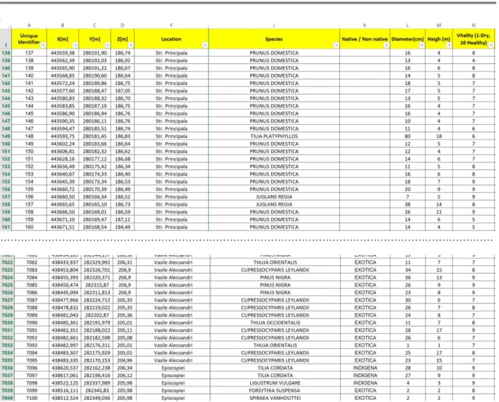
Topographic measurements of green areas and the tree inventory database have been performed with the latest generation GIS and GNSS technology (Herbei, M.V., Sala, F., 2016). In order to acquire GIS data from the field it was used the GIS Leica Zeno 20 instrument, a highly precision GNSS receiver, based on Android operating system (Fig.1).
The field data was collected using the ESRI Collector Software on Android systems, loaded into an updatable database, processed using the ArcGIS v.10.3 software and stored in a geodatabase. The GIS Map of Green Cadastre was realized based on green areas and tree measurements and their coordinates using ArcGIS V.10.3 software.
Fig. 1 Zeno Collector
RESULTS AND DISCUSSIONS
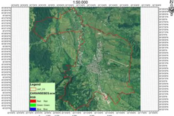
The resulting GIS map with all the Green Cadastre information is a useful instrument for the Municipality in order to easily monitor and permanently have an actual image of the detailed green areas situation (Fig. 2, Fig. 3).
425
Fig. 3 GIS database for Green Cadastre (extract)
The most important feature of a GIS is its ability to perform spatial analysis, to process spatial data (geographic) in order to obtain information (reports), in due time, on the studied area (Fig. 4).
426
The spatial database information can be analyzed in various ways, considering multiple criteria. Fig. 5 and Fig. 6 show answers (examples) for 2 types of queries from Pivot Table, for example: “Viewing all trees from Teius Park” and respectively “Viewing trees with a vitality ranging between 1 and 5, from Teius Park”.
Fig. 5 Pivot Table and chart for Teius Park
Fig. 6 Pivot Table for trees with low vitality from Teius Park
The data can be better valued by publishing a WEB service, for example ArcGIS Online, so a WEB map with the data collected from the field has been created to be easily used by citizens or other interested stakeholders. An example is presented in Fig. 7: a public WEB Map with the Green Area Register in Caransebes.
Fig. 7 Interactive WEB service for Green Area Register GIS data 0 10 20 30 40 50 60 / A CE R … A IL A N TH US … CA ST A N EA … CUPR ES SUS JUG LA N S N IG R A JUN IP ER U S… MA CL URA … MO R US N IG R A PI CE A A BI ES PI N US N IG R A PL A TA N US X… PR U N US A V IU M PSEUDO TS UG A … R H U S T IPH INA R O BI N IA … SA LIX… SO PH O R A … TH UJA … TI LIA …
TEIUS PARK
Total 0 5 10 15TEIUS PARK
…
427
Currently, the Local Green Area Register includes all data (projects, plans, maps, land use types, etc.) related to the green areas system of Caransebeş. This is a set of information gathered by specific methods and procedures, subsequently processed appropriately by programs and stored as a database (GIS). This spatial database is an open system in which real-time changes of the actual existing situation of green spaces and vegetation in Caransebeş municipality can be registered. Thus, any change (setting up a new green space, planting trees, grubbing up sick trees) can be recorded and monitored online. The use of a Green Area Register will facilitate many aspects of urban green space management: maintaining and developing existing green area protection functions; designing and applying a set of appropriate maintenance measures based on outstanding events (storms, diseases or pest attacks, fires etc.); conserving and increasing biodiversity in green spaces. This GIS system can also be used for monitoring green areas and degraded lands that can be redeveloped as green spaces in order to ensure an adequate qualitative level of environmental factors and a high level of the population health.
CONCLUSIONS
The local register of green areas in Caransebeş Municipality was established using modern methods of area measurements, mapping and planning based on a GIS system. The latest generation methods and programs ensuring high precision and accuracy were used, as all the necessary elements in this respect were well determined and analyzed in detail. The Local Registry of Green Spaces in Caransebeş Municipality reflects the situation of the green spaces existing within the limits of the urban area in accordance with the current legal framework. The use of GIS in Green Cadastre lead to a better management of the local green areas potential in Caransebes with direct and important positive implications for the people’s safety and quality of life. Also, the urban green areas system can be expanded more easily by identifying new areas with ecological or socio-cultural potential to be established as green areas with specific present-day requirements in order to serve the citizen’s welfare.
ACKNOWLEDGEMENTS
The financial assistance for this article from the part of research project „Study regarding development strategy of green infrastructure of Caransebeș Municipality” (no. 9450/30.12.2013) is gratefully acknowledged.
BIBLIOGRAPHY
1. Herbei, M.V., 2015 - GIS şi Modelare cartografică, Universitas, p.151-160, Petroşani; 2. Herbei, M.V., Sala, F., 2016 - Biomass prediction model in maize based on satellite images. In AIP Conference Proceedings, Vol. 1738, No. 1, 350009, AIP Publishing;
3. INSSE, 2012 - Rezultatele provizorii ale Recensământul Populației și Locuințelor - 2011;
4. Magina, A., 2008 - Confesiune şi societate în Banatul Montan la graniţa dintre Evul
Mediu şi modernitatea timpurie, în Crisia, nr. XXXVIII, Oradea;
5. Rusu, R., 2007 - Organizarea spaţiului geografic în Banat, Editura Mirton, Timişoara; 6. Szekely, G., Tenche-Constantinescu, A.-M., 2016 - The analysis of the urbanistic and ecological potential for regional development in Caransebeș, SGEM 2016, Albena;