*Corresponding Author:
Email: [email protected] Tel.: +982632801890
Fax: +982188786213
International Journal of Human Capital in Urban Management (IJHCUM)
Homepage: http://www.ijhcum.net/
ORIGINAL RESEARCH PAPER
A spatial decision support system for prioritizing 22 districts of Tehran for
construction of multiplex buildings
S. Pishgahi 1, P. Jafary 2*
1 Department of Urban Planning, University of Art, Tehran, Iran
2 Department of GIS, K.N.Toosi Univ. of Tech., Tehran, Iran
A multiplex is a kind of urban cultural facilities which not only has several different rooms for showing films, but also provides other services such as a wide range of food and drink stores and free/easy available parking. Multiplexes have significant cultural, economic and social characteristics. Given the importance and advantages of multiplexes, several multiplex buildings have been built in Tehran in the last decade. However, many experts doubt that a thorough study has been done on locating them. While, precise locating is associated with more profit, better service and higher social and cultural effects. Therefore, this study reviews different spatial, economic and social criteria (as the most effective criteria on locating urban facilities) so to prioritize 22 districts of Tehran for construction of multiplex buildings. In order to achieve this goal, an index system including 10 various indices was developed. Then, a spatial decision support system was designed and implemented based on two multi criteria decision making models including stepwise weight assessment ratio analysis (SWARA) and fuzzy analytical hierarchy process (Fuzzy AHP). Computation, map production, weighting and combination of different indices and ultimately achieving final output was provided by this system. According to the application of Fuzzy AHP and SWARA models on the indices, it was determined that accessibility and income indices have the most effect on prioritization. The final results of this study indicate that Districts 2, 7 and 11 have the highest priority, and districts 18 and 17 have the least priority for construction of multiplex buildings.
©2019 IJHCUM. All rights reserved. ARTICLE INFO
Article History:
Received 29 December 2018 Revised 22 February 2019 Accepted 11 March 2019
Keywords: 22 districts of Tehran
Fuzzy Analytical Hierarchy Process (Fuzzy AHP)
Multi Criteria Decision Making (MCDM)
Multiplex buildings
Spatial Decision Support System (SDSS)
Stepwise Weight Assessment Ratio Analysis (SWARA)
ABSTRACT
INTRODUCTION
Nowadays, insights on urban cultural facilities such as movie theaters have been changed in urban management issues so that they should be economically viable in addition to providing social and cultural services (Alvarez, 2010). Movie theaters have played a major role in creating media culture
and media production processes in the communities of the 20th century (Pušnik, 2015). General expansion
of malls has been accompanied with the spread of multiplexes. A multiplex is a place which offer a wider choice of films, most feature Surround-Sound systems (360° digital sound), spacious seating, wide screens, wider range of food and drink, air conditioning and free/easy available parking (Hubbard, 2003; Collins et al., 2005). The development of multiplexes has been
S. Pishgahi and P. Jafary
an integral part of the general spread of mall culture, and many multiplexes have been created inside shopping malls. So, They are no longer just places for watching movies, and a variety of retail activities have been done within them (Athique, 2007). The growth of multiplexes has been attributed to the failure of single feature movie theaters in order to capture large enough audiences in increasingly competitive movie-going markets (Turner, 1999). Multiplexes have had important effects on urban leisure time
(Athique, 2011). In Iran, especially in Tehran, several different multiplex buildings have been constructed or are under construction. On the other hand, there is doubt about how accurately they are located. While, precise locating is associated with more profit, better service, higher social and cultural effects and finally sustainable development. Accordingly, the studies carried out by experts and scientists in this regard were reviewed. Almost all of the studies in this area were from the perspective of the design and architecture of multiplex buildings (Ghiai and Sepehr, 2014; Ghorbani and Momeni, 2014; Abbasi Azar, 2016). However, no study has been conducted on the locating optimal places and the spatial analysis of multiplex buildings from the geographic information system (GIS) perspective. In this regard, only studies related to the location of malls can be mentioned. Studies such as using spatial group decision making and geo-social network in order to site selection of shopping centers (Neisani et al., 2018), analyzing spatial distribution of modern commercial centers and their optimal positioning using GIS and analytical hierarchy process (AHP) in Shiraz (Shahabzadeh et al., 2016) and applying Fuzzy AHP method so to locate commercial areas in district 17 of Tehran (Heydar Ali and karimi, 2018). While, multiplexes have specific characteristics and deep social and cultural influences which make them different from malls. These features and differences require specific attention to multiplexes which has been unnoticed in previous studies. So, conducting studies on locating multiplex buildings using new decision making models can help governmental and non-governmental decision makers to get better economic, social and cultural outcomes by creating them in optimal places. Locating an urban space is a complex two level hierarchical problem: at first, macro level analyses should be made in order to assess overall potential areas for an urban space. Subsequently, micro level analyses must be done
to determine the most appropriate site for building an urban space (Sopha et al., 2016). According to
(Hashemkhani Zolfani et al., 2013), locating models for shopping malls have been changed. These models no longer focus only on the proximity to the lodging of citizens, and other important factors such as the attractiveness and ability to meet their needs are also considered in these models. Such an approach can also be considered in relation to multiplex buildings. In this regard, various models which are defined based on Multi-Criteria Decision Making (MCDM) can be used in locating urban spaces (Malczewski and Rinner, 2005). The integration of GIS and MCDM is a process which combines and applies spatial and non-spatial data in order to explore and represent the subjective elements of multi-party conflict and decision making (Feick and Hall, 2001; Rashid, 2018).
Decision making processes based on multi-criteria analysis in GIS environment is an intelligent system that actually make up the base of Spatial Decision Support Systems (SDSS) (Kamali et al., 2017; Jafary et al., 2018). In various aspects of urban management and planning, spatial information play an essential
role (Mueller, 2010). Many urban management and planning data are spatially referenced and can be analyzed using GIS (Barton et al., 2005). The criteria for locating urban facilities can be considered in three perspectives including spatial, social and economic criteria (Qiping et al., 2014). Analysis, evaluation and composition of different criteria can be done in SDSSs based on MCDM (Coutinho-Rodrigues et al.,
2011). Based on above, this study tries to examine the various spatial, economic and social criteria that are effective in locating multiplex buildings in the places under discussion. Then, the study attempt to prioritize the 22 districts of Tehran metropolis for creating multiplexes using the models proposed in multi-criteria decision making. For achievement of this goal, a SDSS will be designed and implemented to automatically perform all required processes. The current study has been carried out in Tehran, Iran in
2019.
MATERIALS AND METHODS
Study area Tehran is the capital of Iran and the administrative center of Tehran Province. This
metropolitan area 638 square kilometer. It is situated
respectively. (Mansori et al., 2018). Tehran has been divided into 22 different districts. Unfortunately, urban facilities are not fairly and correctly shared between these districts (Sadeghi and Zanjari, 2017).
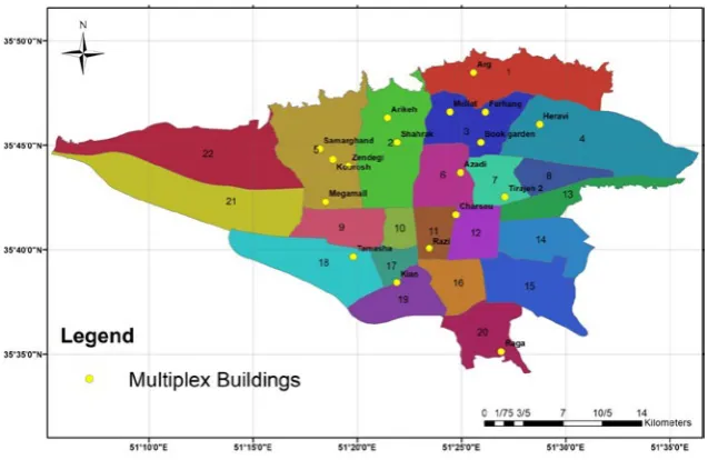
Over the past years, several multiplex buildings have been built in Tehran. The reason for choosing this city as the study area is that this city has always been a top priority for the creation of multiplex buildings, and the largest number of Iran’s multiplex buildings are in this city. Fig. 1 shows the geographic pattern of the 22 districts of Tehran and the distribution of multiplex buildings in them.
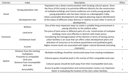
Criteria and Indices
Decision making for locating facilities has a long and extensive history. From the first attempt by Weber in 1909 (Weber, 1909), various scholars have been working in this field. The first important issue in such studies is the establishment of an accurate and optimal criteria system. Because of cultural, social and natural differences of different communities, determining a comprehensive and general criteria for locating urban facilities is a complicated issue. Many urban facility locating problems are inherently multi-objective, which complicates the definition of various criteria (Larson and Stevenson, 1972; Terry Ross and Soland, 1980; Current et al., 1990). In this
study, after studying and evaluating various criteria in valid sources, three types of criteria were chosen
to prioritize optimal districts for the construction of multiplex buildings; including: social, economic and spatial criteria (Teitz, 1968; Banias et al., 2010;
Qiping et al., 2014). Based on these three criteria, introduced indices for the site selection in different scientific resources (especially similar facilities) were reviewed. Although more than 100 indices can be found among various studies, many of them are minor and very similar. Hence, this study tried to integrate them to more general indices. For example, the accessibility index include the accessibility to road networks, railways, pedestrian routes and so forth. Subsequently, 25 related indices were provided. But since the purpose of this study is a special goal for the construction of multiplex buildings, and it is a macro level analysis, four basic issues were examined in relation to these 25 indices. These four constraints include the importance of the index in relation to the specific purpose of the study, the possibility of using index in a macro-level analysis, access to required data and information for the index and the repetition of the index in related academic researches (Table 1).
However, only 10 of indices supported all of the four issues. Hence, these 10 indices were chosen in order to achieve the goal of the study. These indices are
presented in Table 2. Also, a general description for each index and the positive or negative effect of each index on the locating of the multiplex buildings are mentioned in the Table 2.
Fig. 1: Distribution map of multiplex buildings in 22 districts of Tehran
A SDSS for prioritizing Tehran districts for constructing multiplexes
Table 1: Review of 25 initial indices derived from various sources
Index Importance in relation to the purpose of the study Relation to site selection in macro level information required Access to data and valid scientific Repeat in sources
Ability to expand or modify facilities
Access to building materials
Accessibility
Air quality
Compatibility with local resident
Current land use
Development rate
Distance from incompatible land uses
Distance from the existing multiplexes
Entitlement level
Future possible problems
Income
Land price
Landscape of the site
Level of traffic
Noise pollution
Parking convenience
Policy constraints
Proximity to compatible land uses
Subsidies
Topography
Unemployed population
Vegetation
Welfare
Young population rate
Table 1: Review of 25 initial indices derived from various sources
Table 2: Criteria and indices for prioritizing 22 districts of Tehran for the construction of multiplex buildings
Criterion Index Description Effect
Social
Young population rate
Population has a direct communication with locating cultural spaces. Since the focus of this study is to prioritize different districts for the construction of multiplex buildings and cinema audiences are mostly young people, the
young population rate has been chosen as a demographic index.
+
Development rate Urban sustainable development and regional planning require identification of the status of different urban districts in relation to each other in terms of
development. +
Economic
Welfare One of the most important ways to create a suitable living environment is paying attention to the welfare index. +
Land price The price of land varies in different parts of a city. Construction of multiplex buildings more cost-effective in districts with lower prices. -
Entitlement level Considering the homogenization of the districts in terms of having various urban facilities is an issue that can affect urban development plans and allocation of resources so to achieve quantitative and qualitative goals. + Income Higher income levels are associated with higher cultural demands (including cinematic). +
Spatial
Distance from the existing
multiplexes Multiplex buildings should be constructed away from existing multiplexes. - Proximity to compatible
land uses Cultural spaces should be built in the vicinity of their compatible land uses. + Distance from incompatible
land uses Cultural spaces should be built away from their incompatible land uses. - Accessibility Access to public transportation and communication routes is an important factor in evaluating the location of the city's urban facilities. + (Larson and Stevenson, 1972; Bigman and ReVelle, 1978; Yeh and Chow, 1996; Cheng et al., 2005; Cheng et al., 2007; Banias et al., 2010; Önüt et al., 2010; Hashemkhani Zolfani et al., 2013; Taghvaei and Bahari, 2013; Saremi and Toutzari 2014)
Definition of prioritization issue as a MCDM problem
The prioritization of 22 districts of Tehran in order to construct multiplex buildings can be raised as a multi criteria decision making problem. In the beginning of this session, MCDM is reviewed. Then, different levels of prioritization are considered as levels of a hierarchical structure related to MCDM. At the end of this section, two MCDM models used in this study including Stepwise Weight Assessment Ratio Analysis (SWARA) and Fuzzy Analytical Hierarchy Process (Fuzzy AHP) are introduced.
Multi criteria decision making (MCDM)
MultiCriteria DecisionMaking has been developed as a part of operational research. Different criteria defined by decision makers can be subjectively evaluated using designing computational and mathematical tools in MCDM (Zavadskas et al., 2014). Over the past years, various MCDM models have been used to solve a variety of regional issues, such as sustainability, environment and energy. The most well-known MCDM methods are: AHP, TOPSIS, ANP, VIKOR, SAW, DEA, DEMATEL, DEA, ELECTRE, PROMETHEE and their modification, by applying fuzzy and grey number theory. However, the development of hybrid and modular methods has become increasingly important recently. Using these models, such as SWARA, COPRAS, MOORA, MULTIMOORA, ARAS-F, and WASPAS is increasing in solving various real life problems (Mardani et al., 2017).
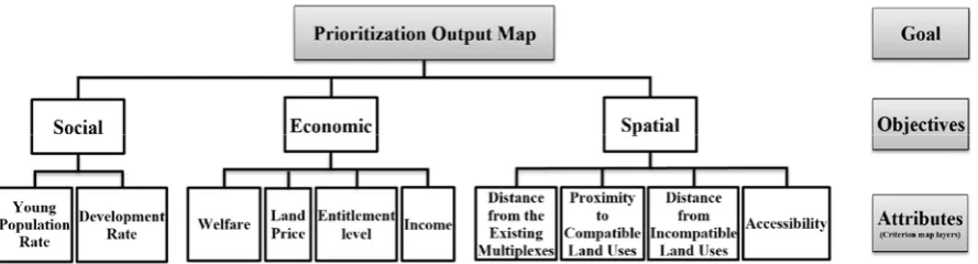
Developing the decision making hierarchy
As the first step in MCDM, decision problem should be decomposed to different levels which consist of the most important components of the problem in a hierarchical structure. Hierarchical structure typically
consists of the goal, objectives, attributes and alternatives (Malczewski and Rinner, 2015). However, based on the conditions and specifications of this study (three levels of goal, criteria and indices), a 3-level hierarchy has been considered to demonstrate the spatial MCDM procedure (Fig. 2). In the proposed
structure, attributes level i.e. criterion map layer is related to the different indices, objectives are social, economic and spatial criteria and the goal layer is the prioritization output map.
Stepwise weight assessment ratio analysis (SWARA)
Stepwise Weight Assessment Ratio Analysis (SWARA) is one of the new methods of MCDM models that was presented in 2010. SWARA is a method in which experts apply their implicit knowledge, experiences and information. In this method, the experts have an important role in evaluating and calculating the weights. First of all, each of the experts prioritizes and ranks the criteria. The most important criterion is ranked as the first criterion and the remaining criteria are ranked according to their importance. Finally, according to the average value of each criterion obtained by a group of experts, the weight of each criterion is determined (Alimardani et al., 2013; Aghdaie et al., 2014).
Fuzzy analytical hierarchy process (Fuzzy AHP)
Various methods have been developed based on MCDM that one of the most well-known is the Analytical Hierarchy Process (AHP) model. In this method relative prioritization between alternatives is carried out in a hierarchical structure based on the expert judgment (Saaty, 1980). Analysis, comparison judgment and combination of the priorities are three principles which the AHP is based on them (Shojaei
Fig. 2: Hierarchical structure of a 3-level decision problem for prioritizing 22 districts of Tehran for construction of multiplex buildings
S. Pishgahi and P. Jafary
et al., 2018). Although AHP is a popular method, it cannot efficiently handle the inevitable uncertainty and low accuracy in converting users’ sights and ideas into the exact numbers (Deng, 1999). This
vagueness associated with decision making in AHP has led researchers into the use of fuzzy logic and combine it with this method so to tolerate vagueness or ambiguity (Mikhailov and Tsvetinov, 2004). Indeed, when humans deal with complex and multi-attribute decision making problems, they cannot express their opinion in the form of precise numerical parameters and prefer to give interval judgments and linguistic variables. Fuzzy AHP method has been developed in such a way that is capable to capture decision makers’ relative judgments (Malczewski, 1999; Erensal et al., 2006). According to Zadeh, (1965)
definition and description of the mathematics of the fuzzy sets: fuzzy set theory is a generalization of classic set theory which allows the membership functions to operate over the range of real numbers [0, 1]. In Fuzzy AHP method uncertain comparison judgments are presented using the fuzzy numbers
(Zadeh, 1965; Vahidnia et al., 2010). In this method, after providing pairwise comparisons matrix with the use of fuzzy numbers and checking the consistency ratio, the final weights can be calculated (Jafary et al., 2018). There are different methods in order to
calculate the weights and preferences of elements in the literatures. Chang, 1996 proposed their most well-known method using the extent analysis method in Fuzzy AHP.
Conceptual design of the SDSS
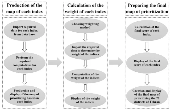
A SDSS is designed and created for automatically performing all prioritizing processes. This procedure is performed in three steps: first, preparation of the map of prioritizing different districts based on each index. Second, calculation of the weight of each index based on SWARA model and Fuzzy AHP model. Finally, applying the weights of different indices, combination of them, and computation of the final score of each district and preparing the final map of prioritizing the districts (Fig. 3).
Social indices
Young population rate: Population data of 22
districts of Tehran was received from Statistical Center of Iran used to achieve young population rate. Young population rate is calculated using Eq. 1.
Young population rate = Population aged1 4 to 40 yearsTotal Population (1)
Development rate index: Sadeghi and Zanjari, 2017
studied spatial inequality of development in the 22
Fig. 3: General view of proposed model: a SDSS for prioritizing 22 districts of Tehran for construction of multiplex buildings
districts of Tehran. In considering development rate index, the results of their study are used.
Economic indices
Welfare: Statistical Center of Iran has determined
the welfare status in 22 Districts of Tehran. This information are used so to achieve welfare index.
Land price: Land price information in different districts of Tehran extracted from credible economic sources. This information is entered into the SDSS as an input for this index.
Entitlement level: The results of a study by Saremi
and Toutzari, 2014 regarding the level of entitlement of urban districts of Tehran are used in order to gain entitlement level index.
Income: Information about the average income of residents in different districts of Tehran was obtained from the Statistical Center of Iran, 2017. The SDSS uses this information in order to achieve income
index.
Spatial indices
Distance from the existing multiplexes
Geographic location of existing multiplex buildings was extracted. The proposed SDSS receives these coordinates. Then, the map of average distance of each districts from existing multiplexes is produced.
Proximity to compatible land uses
Academic, commercial, cultural (such as cultural houses, museums, theaters and etc.) centers and parks were considered as compatible land uses. Geographic location of all these places in Tehran was extracted. The proposed SDSS use these coordinates as the input for the proximity to compatible land
uses index. Then, the map of average distance of each districts from these compatible land uses is automatically produced in SDSS.
Distance from incompatible land uses
Industrial areas, health centers, and vital facilities were considered as incompatible land uses. The coordinates of these facilities were identified. As the previous index, the SDSS produces the map of average distance of each districts from these incompatible
land uses.
Accessibility
Spatial information of the main and secondary communication arteries, terminals, subways and bus lines were used to provide accessibility maps. The SDSS receives the map of them and automatically prepares the map of average distance of each districts from them. Therefore, the accessibility map of the 22 districts of Tehran is provided.
Implementation of the SDSS
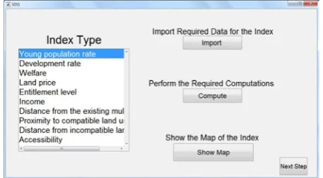
A SDSS, incorporating the previously mentioned features was implemented. This system fulfils the three steps mentioned above to provide the desired outputs. These outcomes include the map of the prioritization of the 22 districts based on each index in the first step, determining the weight of each of the indices based on the SWARA model and Fuzzy AHP model in the second step and ultimately determining the final score of each district and preparing the final map of the prioritization in third step. The user interfaces of the developed SDSS for the implementation of these three steps are presented in
Figs. 4, 5 and 6.
A SDSS for prioritizing Tehran districts for constructing multiplexes
RESULTS AND DISCUSSIONS
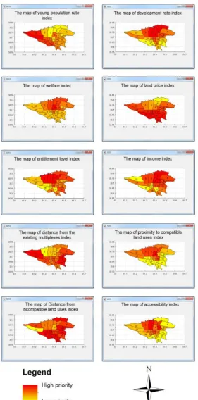
The output related to the first step of the developed SDSS is the map of prioritizing based on each index. The output maps related to each of 10 indices are
presented in Fig. 7. Besides, the districts with the highest and lowest priority for the construction of multiplex buildings based on each index are listed in
Table 3.
The output of the second step is the weight of each index based on SWARA model and Fuzzy AHP model.
The results of weighting indices based on SWARA
method are presented in Table 4. Also, after checking consistency ratio of pairwise comparisons, the results for determining the weight of each index based on Fuzzy AHP method that are calculated according to the Chang’s method (Chang, 1996),are presented in
Table 5.
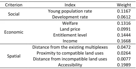
According to the calculated weights based on both of two models, it is seen that accessibility and income indices have the greatest impact on prioritizing the
Fig. 6: The user interface of the SDSS; Third step: Preparing the final map of prioritizing the districts
Fig. 5: The user interface of the SDSS; Second step: Calculation of the weight of each index Fig. 5: The user interface of the SDSS; Second step: Calculation of the weight of each index
Fig. 6: The user interface of the SDSS; Third step: Preparing the final map of prioritizing the districts
Table 3: Districts with the highest and lowest priority for the construction of multiplex buildings based on each index
Index Districts with the highest priority Districts with the lowest priority
Young population rate 21, 22 2, 8
Development rate 1, 2, 3, 6 15, 17, 18, 19
Welfare 6 17
Land price 18, 20 1, 3
Entitlement level 1, 3, 5, 6 9, 16, 17, 18
Income 1, 3, 6, 7 10, 16, 17, 18, 22
Distance from the existing multiplexes 13, 14, 15, 21, 22 5
Proximity to compatible land uses 6 8, 9, 13, 14, 15, 16, 17, 18, 19, 20 Distance from incompatible land uses 1, 6, 7, 8, 9, 13, 14, 16, 17, 18, 19, 20 21, 6
Accessibility 2, 7 1, 4, 14, 15, 19, 20
S. Pishgahi and P. Jafary
Table 4: Final results of SWARA Method in weighting indices
Index Sj* Kj** Wj*** qj**** Young population rate 1.00 1.0000 0.0933
Development rate 0.2 1.20 0.8333 0.0712
Welfare 0.19 1.19 0.7003 0.1092
Land price 0.18 1.18 0.5935 0.0805 Entitlement level 0.17 1.17 0.5072 0.1289
Income 0.16 1.16 0.4373 0.1533
Distance from the existing
multiplexes 0.13 1.13 0.3870 0.0641 Proximity to compatible land
uses 0.11 1.11 0.3486 0.0594
Distance from incompatible
land uses 0.08 1.08 0.3228 0.0560 Accessibility 0.06 1.06 0.3045 0.1840 *The comparative importance of average value; **Coefficient 𝑘𝑘𝑘𝑘
𝑗𝑗𝑗𝑗=𝑠𝑠𝑠𝑠𝑗𝑗𝑗𝑗+ 1;
***Recalculated weight𝑤𝑤𝑤𝑤
𝑗𝑗𝑗𝑗=𝑥𝑥𝑥𝑥𝑗𝑗𝑗𝑗−1𝑘𝑘𝑘𝑘𝑗𝑗𝑗𝑗; ****Weight 𝑞𝑞𝑞𝑞𝑗𝑗𝑗𝑗=𝑤𝑤𝑤𝑤𝐾𝐾𝐾𝐾𝑗𝑗𝑗𝑗𝑗𝑗𝑗𝑗
Table 4: Final results of SWARA Method in weighting indices
Table 5: Final results of Fuzzy AHP Method in weighting indices
Criterion Index Weight
Social Young population rate Development rate 0.1167 0.0612
Economic
Welfare 0.1316
Land price 0.0991
Entitlement level 0.1444
Income 0.1668
Spatial
Distance from the existing multiplexes 0.0472 Proximity to compatible land uses 0.0264 Distance from incompatible land uses 0.0077
Accessibility 0.1989
Table 5: Final results of Fuzzy AHP Method in weighting indices
districts for the construction of multiplex buildings. After these two indices, entitlement level and welfare indices have more weights. Also, the lowest weights have been assigned to proximity to compatible land uses and distance from incompatible land uses indices. Finally, after acquiring the map of different indices and calculating the weight of each of them, the weights can be applied on indices in the third step of the SDSS. After applying the weights and combining different indices, the final score of each district was determined (Table 6). Subsequently, the final maps of prioritizing using SWARA and Fuzzy AHP were prepared (Figs. 8 and 9).
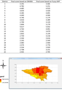
According to the final results of both models, districts 2, 7 and 11 have the highest priority for the construction of multiplex buildings, respectively. Regarding the districts with low priority, districts 18 and 17 have the lowest priority based on SWARA model. However, districts 16 and 22 are also joined
these areas had a low priority in development rate, welfare, entitlement level, income and proximity to compatible land uses indices (Table 3). What is clear is that these districts are among the deprived areas of Tehran. So, construction of multiplex buildings and huge malls in these areas is not a priority, but other important facilities and services must first be constructed and provided in these places in order to increase the level of development and entitlement of
these areas.
Uncertainty Analysis of the Model
In order to discuss the uncertainty of prioritization indices in this study, the calculated weights for each
index can be reviewed. Based on the weighting results of two models, accessibility index has the greatest impact on prioritizing the districts for the construction of multiplex buildings. This confirms the results of (Hashemkhani Zolfani et al., 2013; Önüt et al., 2010) in similar cases. Therefore, this index has the highest certainty in the developed model. After that, income, entitlement level and welfare indices have high weights. These three indices examine various aspects of the financial and welfare state of citizens, which have a significant impact on model outcomes and high certainty. In addition, proximity to compatible land uses and distance from incompatible land uses indices, which low weights were assigned
Table 6: Final score of each district
District Final score based on SWARA Final score based on Fuzzy AHP
1 3.191 3.305
2 4.782 5.251
3 4.485 4.919
4 3.054 3.420
5 4.185 4.691
6 4.440 4.946
7 4.746 5.174
8 3.010 3.289
9 2.799 3.129
10 2.894 3.179
11 4.617 5.032
12 3.763 4.091
13 3.361 3.679
14 2.832 3.139
15 2.759 3.218
16 2.344 2.616
17 2.195 2.549
18 2.083 2.400
19 2.374 2.776
20 2.534 2.920
21 2.708 3.231
22 2.501 2.705
Table 6: Final score of each district
Fig. 8: Prioritization map of 22 districts of Tehran for construction of multiplex buildings based on SWARA Method
A SDSS for prioritizing Tehran districts for constructing multiplexes
to them, are more related to micro level analysis for locating. Hence, with regard to the purpose of this study at macro level investigation, the uncertainty of these indices are high in the model.
Model and SDSS evaluation
The model presented in this study include two sections. At first, an index system has been defined; second, prioritization of districts for the construction of multiplex buildings has been raised as a MCDM problem in order to design a conceptual model of a SDSS for problem solving. In the first section it was seen that according to the purpose of each site selection study at macro or micro scales, all relevant indices can be first extracted. Then, by applying different constraints, a system of appropriate indices can be prepared. Such an approach can be used in dealing with different facilities for the establishment of the index system. In the second part after defining the MCDM problem, two weighting methods were applied. The weighting results were close. So it can be discussed that this study achieved the same results by using two valid weighting methods. Therefore, it can be noted that these two methods show the validity of each other, and the result can indicate the validity of the final output of the study. Since the SWARA model is a more simple method, and it is not as complicated as Fuzzy AHP, this new model can be applied by different researchers in future studies. After defining, implementing and applying the SDSS, it was seen that the development of such systems can accelerate the performance of similar studies. In fact, this SDSS can be easily used to map the priority of districts for the construction of multiplex buildings in other cities. For this purpose, it is enough that the prerequisite
data related to each index in the respective city be prepared and imported into system. Furthermore, such system can be developed for the site selection of other facilities. The benefits of such a system are the high speed of the production of output maps and the ability to deploy in different areas.
CONCLUSION
According to the importance of cultural facilities such as multiplexes in urban planning and decision making, it is essential to conduct comprehensive and accurate studies to find the optimal location for the construction of such facilities. Due to the lack of such studies in order to locate multiplex buildings in Tehran, this study, as the first research in this field in Iran, tried to prioritize 22 districts of Tehran for the construction of multiplex buildings. An index system was developed and all necessary processes were automatically performed using a Spatial Decision Support System based on 2 Multi Criteria Decision Making models. It was investigated that Districts 2, 7 and 11 have the highest priority. So it can be suggested that governmental and non- governmental urban decision makers to focus on these districts for the construction of multiplex buildings. In future studies, micro level analyses can be done in these districts to determine the most appropriate site for the construction of multiplex buildings. Another important issue that this study can recommend to policy and decision makers is that although deprived areas such as the Districts 17 and 18 do not have priority for the creation of multiplex buildings, expansion of necessary urban facilities and services is crucial in these areas. The model was defined and developed in such a way that it can be used in Fig. 9: Prioritization map of 22 districts of Tehran for construction of multiplex buildings based on Fuzzy
AHP Method
other studies not only on multiplexes, but also on other kind of urban facilities. In addition, this model can be applied on other index systems. Particularly, it was found that SWARA Model has high validity, and it is recommended to researchers due to its ease of use. It should be noted that the developed Spatial Decision Support System can be easily used in order to prioritize other cities for the construction of multiplex buildings. It is enough to provide the basic data necessary for each index in the respective city and import into the system.
ACKNOWLEGEMENT
We would like to express our sincere gratitude to the editor and anonymous reviewers for their constructive comments.
CONFLICT OF INTEREST
The author declares that there is no conflict of interests regarding the publication of this manuscript. In addition, the ethical issues, including plagiarism, informed consent, misconduct, data fabrication and/ or falsification, double publication and/or submission, and redundancy have been completely observed by
the authors.
REFERENCES
Abbasi Azar, M., (2016). A planning pattern for multiplex design with appropriate urban space approach. Paper presented at the 2nd Scientific Conference on Modern Horizons in Geography and Planning, Architecture and Urban Science, Tehran, Iran (11 pages). (In Persian)
Aghdaie, M.H.; Zolfani, S.H.; Zavadskas, E.K., (2014). Synergies of data mining and multiple attribute decision making. Procedia. Soc. Behav. Sci., 110: 767-776 (10 pages).
Alimardani, M.; Hashemkhani Zolfani, S.; Aghdaie, M.H.; Tamošaitienė, J., (2013). A novel hybrid SWARA and VIKOR methodology for supplier selection in an agile environment. Technol. Econ. Dev. Econ., 19(3): 533-548 (16 pages).
Alvarez, M.D., (2010). Creative cities and cultural spaces: new perspectives for city tourism. Int. J. Cult. Tourism. Hospit. Res., 4(3): 171-175 (6 pages).
Athique, A., (2011). From cinema hall to multiplex: A public history. S. Asian. Popular. Cult., 9(2): 147-160 (14 pages).
Athique, A.; Douglas, H., (2007). Multiplex cinemas and urban redevelopment in India. Media. Int. Aust., (124): 108-118 (11 pages). Banias, G.; Achillas, C.; Vlachokostas, C.; Moussiopoulos, N.; Tarsenis,
S., (2010). Assessing multiple criteria for the optimal location of a construction and demolition waste management facility. Build. Environ., 45(10): 2317-2326 (11 pages).
Barton, J.; Parolin, B.; Weiley, V.A., (2005). A spatial decision support system for the management of public housing. In: Van Leeuwen, J.P.; Timmermans, H.J.P., (eds), Recent advances in design and
decision support systems in architecture and urban planning. Dordrecht, Springer Netherlands, 69-84 (16 pages).
Bigman, D.; ReVelle, C., (1978). The theory of welfare considerations in public facility location problems. Geogr. Anal., 10(3): 229-240 (12 pages).
Chang, D.Y., (1996). Applications of the extent analysis method on fuzzy AHP. Eur. J. Oper. Res., 95(3): 649-655 (7 pages).
Cheng, E.W.L.; Li, H.; Yu, L., (2005). The analytic network process (ANP) approach to location selection: A shopping mall illustration. Constr. Innovat., 5(2): 83-97 (15 pages).
Cheng, E.W.L.; Li, H.; Yu, L., (2007). A GIS approach to shopping mall location selection. Build. Environ., 42(2): 884-892 (9 pages). Collins, A.; Hand, C.; Ryder, A., (2005). The lure of the multiplex? The
interplay of time, distance, and cinema attendance. Environ. Plan. A. Icon. Space., 37(3): 483-501 (9 pages).
Coutinho-Rodrigues, J.; Simão, A.; Antunes, C.H., (2011). A GIS-based multicriteria spatial decision support system for planning urban infrastructures. Decis. Support. Syst., 51(3): 720-726 (6 pages). Current, J.; Min, H.; Schilling, D., (1990). Multiobjective analysis of
facility location decisions. Eur. J. Oper. Res., 49(3): 295-307 (13 pages).
Deng, H., (1999). Multicriteria analysis with fuzzy pairwise comparison. Int. J. Approx. Reason., 21(3): 215-231 (17 pages). Erensal, Y.C.; Öncan, T.; Demircan, M.L., (2006). Determining key
capabilities in technology management using fuzzy analytic hierarchy process: A case study of Turkey. Inf. Sci., 176(18): 2755-2770 (16 pages).
Feick, R.D.; Hall, G.B., (2001). Balancing consensus and conflict with a GIS-based multi-participant, multi-criteria decision support tool. GeoJournal., 53(4): 391-406 (16 pages).
Ghiai, M.M.; Sepehr, M., (2014). The effect of multiplex design on culture, identity and urban landscape. Paper presented at the National Conference on Architecture and Sustainable Urban Landscape, Mashhad, Iran (14 pages). (In Persian)
Ghorbani, N.; Momeni, K., (2014). The relationship between technology and architecture on the Mellat multiplex. Paper presented at the National Conference on Sustainable Urban Development, Tabriz, Iran (6 pages). (In Persian)
Hashemkhani Zolfani, S.; Aghdaie, M.H.; Derakhti, A.; Zavadskas, E.K.; Morshed Varzandeh, M.H., (2013). Decision making on business issues with foresight perspective; an application of new hybrid MCDM model in shopping mall locating. Expert. Syst. Appl., 40(17): 7111-7121 (11 pages).
Heydar Ali, M.; Karimi, S., (2018). Commercial areas locate region 17 of Tehran using fuzzy AHP method. J. Environ. Sci. Tech., 20(6): 123-138 (16 pages). (In Persian)
Hubbard, P., (2003). A good night out? Multiplex cinemas as sites of embodied leisure. Leis. Stud., 22: 255-272 (18 pages).
Jafary, P.; Sarab, A.A.; Tehrani, N.A., (2018). Ecosystem health assessment using a fuzzy spatial decision support system in Taleghan watershed before and after dam construction. Environ. Process., 5(4): 807-831 (25 pages).
Kamali, M.; Alesheikh, A.A.; Alavi Borazjani. S.A.; Jahanshahi, A.; Khodaparast, Z.; Khalaj, M., (2017). Delphi-AHP and weighted index overlay-GIS approaches for industrial site selection case study: Large extractive industrial units in Iran. J. Settlement. Spatial. Plan., 8(2): 99-105 (7 pages).
S. Pishgahi and P. Jafary
COPYRIGHTS
Copyright for this article is retained by the author(s), with publication rights granted to the IJHCUM Journal. This is an open-access article distributed under the terms and conditions of the Creative Commons Attribution License (http://creativecommons.org/licenses/by/4.0/).
HOW TO CITE THIS ARTICLE
Pishgahi, P., Jafary, P., (2019). A spatial decision support system for prioritizing 22 districts of Tehran for construction of multiplex buildings. Int. J. Hum. Capital Urban Manage., 4(2): 87-100.
DOI:10.22034/IJHCUM.2019.02.02
url: http://www.ijhcum.net/article_35840.html
Malczewski, J., (1999). GIS and multicriteria decision analysis. Wiley, New York [U. A.].
Malczewski, J.; Rinner, C., (2005). Exploring multicriteria decision strategies in GIS with linguistic quantifiers: A case study of residential quality evaluation. J. Geogr. Syst., 7(2): 249-268 (19 pages).
Malczewski, J.; Rinner, C., (2015). Multicriteria decision analysis in geographic information science. New York: Springer.
Mansori, K.; Mosavi-Jarrahi, A.; Ganbary Motlagh, A.; Solaymani-Dodaran, M.; Salehi, M.; Delavari, A.; Sanjari Moghaddam, A.; Asadi-Lari, M., (2018). Exploring spatial patterns of colorectal cancer in Tehran city, Iran. Asian. Pac. J. Cancer. Prev., 19(4): 1099-1104 (6 pages).
Mardani, A.; Nilashi, M.; Zakuan, N.; Loganathan, N.; Soheilirad, S.; Saman, M.Z.M.; Ibrahim, O., (2017). A systematic review and meta-analysis of SWARA and WASPAS methods: Theory and applications with recent fuzzy developments. Appl. Soft. Comput., 57: 265-292 (28 pages).
Mikhailov, L.; Tsvetinov, P., (2004). Evaluation of services using a fuzzy analytic hierarchy process. Appl. Soft. Comput., 5: 23-33 (7 pages).
Mueller, H., (2010). Spatial information management, an effective tool to support sustainable urban management. Paper presented at the 46th ISOCARP Congress 2010, Nairobi, Kenya (12 pages). Neisani, Z.; Karimi, M.; Alesheikh, A.A., (2018). Development of
an urban public service site selection tool using spatial group decision making and geo-social network (case study: site selection of shopping centers). J. Geomatics. Sci. Technol., 7(3): 151-160 (10 pages). (In Persian)
Önüt, S.; Efendigil, T.; Soner Kara, S., (2010). A combined fuzzy MCDM approach for selecting shopping center site: an example from Istanbul, Turkey. Expert. Syst. Appl., 37(3): 1973-1980 (8 pages). Pušnik, M., (2015). Cinema culture and audience rituals: Early
mediatisation of society. Anthropol. Noteb., 21(3): 51-74 (14 pages).
Qiping, S.; Hao, W.; Bo-sin, T., (2014). A decision-making framework for sustainable land use in Hong Kong’s urban renewal projects. Smart. Sustain. Built. Environ., 3(1): 35-53 (19 pages).
Rashid, M.F.A., (2018). Capabilities of a GIS-based multi-criteria decision analysis approach in modelling migration. GeoJournal, 84(2): 483-496 (14 pages).
Saaty, T.L., (1980). The analytic hierarchy process: planning, priority setting, resource allocation. McGraw-Hill, New York.
Sadeghi, R.; Zanjari, N., (2017). The inequality of development in the
22 districts of Tehran metropolis. Soc. Welfare. Quarter., 17(66): 149-184 (16 pages). (In Persian)
Saremi, H.; Toutzari, S., (2014). Assessment and evaluation of entitlement levels of urban zones of Tehran metropolitan using TOPSIS technique. Haviateshahr, 8(18): 47-60 (14 pages). (In Persian)
Shahabzadeh, M.; Peyvastegar, Y.; Heydari, A.A., (2016). Spatial distribution analysis of modern commercial centers of Shiraz and optimal positioning by using GIS and AHP. J. Zonal. Plan., 6(23): 99-112 (14 pages). (In Persian)
Shojaei, S.; Alipur, H.; Ardakani, A.H.H.; Nasab, S.N.H.; Khosravi, H., (2018). Locating Astragalus hypsogeton Bunge appropriate site using AHP and GIS. Spatial. Inf. Res., 26(2): 223-231 (9 pages). Sopha, B.M.; Asih, A.M.S.; Pradana, F.D.; Gunawan, H.E.; Karuniawati,
Y., (2016). Urban distribution center location: Combination of spatial analysis and multi-objective mixed-integer linear programming. Int. J. Eng. Bus. Manag., 8: 1-10 (10 pages). Statistical Centre of Iran, (2017). Findings of the 2011 national
population and housing census Tehran: Statistical Center of Iran. [Online]
Taghvaei, M.; Bahari, I., (2013). Assessing development degree and ranking townships of Mazandaran Province by using factor analysis and cluster analysis. Geogr. Environ. Plan., 4(48): 7-20 (14 pages). (In Persian)
Teitz, M.B., (1968). Toward a theory of urban public facility location. Pap. Reg. Sci., 21(1): 35-51 (17 pages).
Terry Ross, G.; Soland, R.M., (1980). A multicriteria approach to the location of public facilities. Eur. J. Oper. Res., 4(5): 307-321 (15 pages).
Turner, G., (1999). Film as Social Practice. Routledge, London. Vahidnia, M.H.; Alesheikh, A.A.; Alimohammadi, A.; Hosseinali,
F., (2010). A GIS-based neuro-fuzzy procedure for integrating knowledge and data in landslide susceptibility mapping. Comput. Geosci., 36(9): 1101-1114 (14 pages).
Weber, A., (1909). über den Standort der Industrien. University of Chicago Press.
Yeh, A.G-O.; Chow, M.H., (1996). An integrated GIS and location-allocation approach to public facilities planning—an example of open space planning. Comput. Environ. Urban. Syst., 20(4): 339-350 (12 pages).
Zadeh, L.A., (1965). Fuzzy sets. Inf. Contr., 8: 338-353 (16 pages). Zavadskas, E.K.; Turskis, Z.; Kildienė, S., (2014). State of art surveys of