International Journal of the Society of Iranian Archaeologists Vol. 3, No. 5, Winter- Spring 2017
In search of Neolithic Appearance along
the Northern Shorelines of the Persian Gulf:
A Report on the Excavation at the
Pre-pottery Neolithic Site
of Tapeh Mahtaj, Behbahan Plain
Hojjat DarabiRazi University, Iran
Mojtaba Aghajari Independent Researcher, Iran
Meisam Nikzad
Tarbiat Modares University, Iran Saeed Bahramiyan University of Tehran, Iran
Received: April 12, 2016 Accepted: October 23, 2016
Abstract: Tapeh Mahtaj is the earliest known occupation that has yet been discovered in the eastern plains of southwestern Iran. The site contains Pre-Pottery Neolithic deposits, ca. 40 cm in depth. The available finds suggest that the site was seasonally occupied during the second half of the 8th millennium bc. Three occupational phases were recognized at the site. The upper levels witnessed the introduction of obsidian into the region and also contained a large amount of grinding stones that were not in their primary context. Tapeh Mahtaj provides crucial information on the appearance of agriculture in the plains, which were closer to the coast line 10,000 years ago than today. This issue provides us with information on the Neolithization of the Persian Gulf Oasis.
Keywords: Pre-Pottery Neolithic, Tapeh Mahtaj, Behbahan, Persian Gulf Oasis.
* Hojjat Darabi
Department of Archaeology, Razi University, Kermanshah, Iran. hojjatdarabi@gmail.com
Mojtaba Aghajari
Independent Researcher, Iran.
Meisam Nikzad
Department of Archaeology,
Tarbiat Modares University, Tehran, Iran.
Saeed Bahramiyan
Department of Archaeology, University of Tehran, Tehran, Iran. Introduction
Iran has generally been the focus of research into the Neolithic period later than adjacent regions in the Near East (see Smith 1971: 6); in addition, there is a geopgraphic disparity across Iran in terms of research intensity. In this respect, the central Zagros has been more intensively studied than other areas and, in turn, has produced early evidence related to the emergence of agriculture and sedentary life (see Braidwood 1960, 1961; Braidwood et al. 1961; Mortensen 2014; Smith 1972, 1976; Pullar 1990; Matthews et al. 2013; Darabi 2012, 2015; Darabi et al. 2011, 2013; Riehl et al. 2012, 2013, 2015). Recent investigations in southern Zagros, however, have pushed back the beginning of Neolithic occupation in this region (see Azizi Kharanaghi 2013; Tsuneki 2013; Weeks 2013). Therefore, work in these two regions has begun to change our previous understandings of the Neolithization process. Despite this new work, the picture is far from complete.
International Journal of the Society of Iranian Archaeologists Vol. 3, No. 5, Winter- Spring 2017
(see Hole et al. 1969; Hole 1977; Alizadeh 2003). Across lowland southwestern Iran the eastern plains, including Ramhormoz, Behbahan, and Zohreh, to the southeast, had previously mostly produced evidence for later prehistoric occupations from the Chalcolithic onwards (see Alizadeh 2014; Dittman 1984; Moghaddam 2012a,b, 2016; Moghaddam and Miri 2007; Wright 1969; Wright and Carter 2003), whereas remains of earlier settlements, in particular the early Neolithic, were unknown until now. Tapeh Mahtaj is the first site that sheds light on this previously-unknown timespan in these regions, which ecologically connect the highland Zagros to the Persian Gulf. This article briefly discusses the preliminary finds from our excavations at Tapeh Mahtaj and attempts to begin to situate the site within its wider geographical and chronological context. It should be stated that analyses, including radiocarbon dating, archaeobotanical and zooarchaeological analyses, are currently in progress and will in the future provide further crucial information on the early Neolithic in the lowlands.
Environmental setting
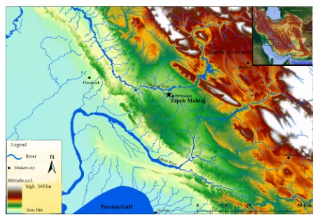
The Behbahan Plain lies in southwestern Iran, ca. 160km to the southeast of Ahvaz, Khuzestan Province, and ca. 45 km to the north of the Persian Gulf shoreline, at an elevation of roughly 300-600m above sea level (Fig. 1).
As an enclosed plain, it is about 25km long and 10 km wide. Similar to other alluvial plains of the region, it is geomorphologically formed by the Quaternary sediments though earlier geological formations are also present in the surrounding areas (Fig. 2). Generally speaking, three alluvial fans played the main role in the formation of the Behbahan Plain. The main water supply of the region is the Maroon River which drains from the mountains to the north of Yasuj and flows through the plains of Behbahan, Jayezan and Ramhormoz before joining the Persian Gulf as Jarrahi River. The southern border of the Behbahan Plain, is marked by the Milak stream, which - as a tributary of the Maroon River - flows from the south of Behbahan city to the west. These two water supplies are the main niches for various plant and animal species such as tamarisk, reeds, wild boar, aquatics and different fowls. As the plain has fertile soil, it is heavily cultivated in order to grow various agricultural products. To the north of the plain the Khuviz anticline, a part of the Zagros range, provided a different landscape that is mostly dominated by multiple species, notably oak, wild pistachio, almond and maple and wild animals such as goats and sheeps. It should be noted that, based on the available multi-proxy paleoenvironmental data, forestation of the Zagros had gradually begun by the advent of the Holocene when temperature, moisture and precipitation increased (see van Zeist & Wright 1963: 65; van Zeist & Bottema 1977; Snyder et al. 2001; Wasylikowa
International Journal of the Society of Iranian Archaeologists Vol. 3, No. 5, Winter- Spring 2017
et al. 2006). However, these different niches were the foundation upon which the occupation of the Behbahan Plain, at least during the early prehistoric times, depended.
Archaeological Backgrounds
Archaeologically, the Behbahan Plain is known as a part of “Greater Susiana” that, in a northwest-southeast orientation, extends from the Mehran Plain to the Zohreh Plain, and geomorphologically forms the lowlands of southwestern Iran (see Kouchoukos and Hole 2003; Moghaddam 2012a,b). This large region, however, witnessed variable degrees of archaeological research. While some areas such as the Susiana Plain were studied intensively, other areas were rarely and only partially investigated. The Behbahan Plain was first surveyed by H. Nissen who also made soundings at Tapeh Sohz in 1970 (Nissen 1973, Nissen and Redman 1971; Dittmann 1984). The most spectacular archaeological discovery on the plain, however, was the Neo-Elamite assemblage which was accidentally found at Arjan in the early 1980s (see Alvarez-Mon 2006; Alizadeh 1985). In 2008, a reconnaissance survey of the Behbahan plain, directed by K. Abdi (2008), was carried out. Despite these two previous surveys, which aimed to detect and locate new archaeological sites, Tapeh Mahtaj was unknown until recently when new archaeological investigations were begun by A. Moghaddam. After
directing salvage excavations at Chah-e Naft, a site dated to early 5th millennium bc, he carried out a survey
in the surrounding area to locate earlier sites, dated to Neolithic time. Tapeh Mahtaj was found as part of this survey (Moghaddam 2014). It is worth noting that former investigations had attributed the earliest occupation of the plain to the 5th millennium bc, i.e. middle village period
(cf. Moghaddam 2012a). However, the discovery of Tapeh Mahtaj clearly indicates that human settlement in the region was also present during the early Holocene.
Tapeh Mahtaj
Tapeh Mahtaj (423772 N 3389461 E) is located on the southernmost part of the Behbahan Plain, some 3.5 km to the west-northwest of Behbahan city and 1 km to the south of Ramhormoz-Behbahan road, at an elevation of 310m above sea level. In fact, the site consists of a natural hillock, 1-2m above the surrounding fields measuring150×70m in area. As the site surface has recently been bulldozed, however, it is probable that the upper part has been truncated, and that the mound was originally higher. Therefore, later deposits, presumably dating to the Pottery Neolithic, appear to have been wholly destroyed and removed. It should be noted that some very primitive fragments of pottery were found during delimitation, but no in situ samples discovered from the excavation. Tapeh Mahtaj is now being used for
International Journal of the Society of Iranian Archaeologists Vol. 3, No. 5, Winter- Spring 2017
temporary storage of agricultural products and is entirely encircled by irrigation channels (Fig. 3). Some 300 m to the south, the Milak stream runs westward and finally joins the Maroon River 3.5 km away. Milak marks the southern border of the alluvial plain with the Shirali hills to the south. Thus, it is thought that the site was established in the middle of different ecotones which could have provided its inhabitants with easy access to a wide spectrum of the surrounding resources.
Objectives
Due to the archaeological importance of the site and the threats from bulldozing and agricultural activity to its continued preservation an archaeological project was initiated to delineate and also investigate the site in 2015. Excavations started out with test pits, which aimed to delineate the total size of the site. Then the main excavation carried out at the summit and central part of the mound. As noted above, the eastern plains of Khuzestan, including Behbahan, were thought to have been first occupied only during the 5th millennium bc as the result of over-population
in the Susiana Plain (Wright 1969, 1987; Moghaddam 2012a,b). Earlier remains, therefore, merit attention and, in this regard, Tapeh Mahtaj is an important place. The Behbahan Plain is geographically located between the central and southern Zagros. On the one hand, the central Zagros, to the northwest, contains the earliest evidence for Neolithic settlement (Braidwood 1960, 1961; Braidwood
et al. 1961; Mortensen 1974, 2014; McDonald 1979; Smith 1972, 1976; Pullar 1990; Matthews et al. 2013; Darabi et al. 2011, 2013; Darabi 2012, 2015; Riehl et al. 2012, 2013, 2015); on the other hand, recently-found evidence suggests that at least some inter-mountain valleys in the southern Zagros, to the southeast, were also under occupation since the beginning of the Holocene (Azizi Kharanaghi 2013; Tsuneki 2013; Weeks 2013); furthermore, the lowlands such as Deh Luran and Susa plains appear to have been inhabited since themid-8th millennium bc onward (Alizadeh
2003; Hole 1987; Hole et al. 1969) and this might have been as the result of population pressure in the Central Zagros (Darabi 2012, 2015). However, the same idea has more or less been put forward also for the southern Zagros, in that the Neolithic in this region may have derived from the Neolithic of the central Zagros (Azizi Kharanaghi 2013). If so, the regions in between, such as the Behbahan Plain, merit consideration if we want to tackle the question to what extent the Neolithic was derived from the highlands of the central Zagros. The degree to which local people took steps toward the Neolithic world with respect to the surrounding environmental possibilities should also be given attention. Tapeh Mahtaj is the closest early Neolithic site to the Iranian shores of the Persian Gulf yet discovered. The site may therefore hold some crucial information with regards to the “[Persian] Gulf Oasis Hypothesis”, which suggests the appearance of Neolithic populations as a result of sudden sea level rise (see Rose 2010). The objectives of our fieldwork can be summarized as follow:
International Journal of the Society of Iranian Archaeologists Vol. 3, No. 5, Winter- Spring 2017
Fig. 4. A general view of the middle phase in the main trench, looking north
International Journal of the Society of Iranian Archaeologists Vol. 3, No. 5, Winter- Spring 2017
-To delineate the site’s area via making small sondages -To determine the timing and nature of occupation(s) at the site
-To understand the subsistence strategies of the site’s occupants through time
-To reconstruct the possible connections with surrounding regions, i.e. central Zagros and southern Zagros, during the Neolithic
-To investigate the role of sea-level fluctuations in the process of Neolithization in the region of the Persian Gulf. Given the present state of research, with most of the excavated finds still under study, we cannot at present address all of these objectives. In this paper, we aim to share our preliminary results from the excavations and will briefly describe architecture, chipped stone industry and ground stone artefacts.
The Excavation
In terms of preservation, as previously noted, the site was not in a good condition and mostly was already bulldozed; therefore, we first aimed to delineate the site by making some small sondages around in the presumed edges in June-July 2015. Eight sondages, each measuring 1.5×1m in area (see Fig. 3), were dug to clarify the extent of the site and to therefore propose the area that has to be protected from further bulldozing and agricultural work. The sondages indicate that the archaeological site of Tapeh
Mahtaj measures approximately 1.5 ha in area. The mound was truncated and flattened by bulldozer, which resulted in a loss of the upper layers of archaeology, as well as in a lack of variation in site elevation. A brief walk-over survey showed that some areas have denser concentrations of surface finds, mainly broken pieces of grinding stones such as hand stone and pounder. One of these dense concentrations was selected for further excavations. The main excavation area, which initially measured 2×2m in size, was placed over the central part of the site. Through cleaning sections that were made by the irrigation channels, we had already found some clues to the possible depth of the remaining deposits at the site. To gain further clarity of the total depth of deposits, a test pit was excavated down to natural in the northern part of the main excavation area at the beginning of the excavation. Since the virgin soil was soon reached in this sondage, ca. 40 cm below the topsoil, the excavation area was extended and finally a 4×4m area was entirely dug down to the virgin soil (Fig. 4). During the excavation, apart from those samples taken for later analyses, all the soil was dry-sieved through a 2×2 mm mesh. In addition, soil samples for phytolith, pollen and micro-morphological analyses collected. Moreover, some stone tools and charcoal pieces were bagged and registered for use-wear analysis and radiocarbon dating. These analyses will surely help to gain a better understanding of the site’s inhabitants.
International Journal of the Society of Iranian Archaeologists Vol. 3, No. 5, Winter- Spring 2017
Archaeological Finds
Three archaeological phases were discernable based on architectural remains and archaeological deposits. The upper phase was heavily damaged and, thus, no solid in situ architecture was found; the phase consisted mostly of a scatter of pebbles, which may represent rubble from a disturbed or destroyed building (see Fig. 4). A thin layer of sterile sediment separated the upper from the middle phase. Finds densities increased significantly suggesting that the excavations had reached an occupation level. The most significant features in the middle phase was the footprint of a rectangular structure, measuring 3×2m in size, which was built using various-sized pebbles oriented on a northeast-southwest alignment (Fig. 5). No entrance was found. Broken grinding stones were reused as building material in the walls of the structure.
Unlike the upper and middle phases, the lower phase is distinguished by the presence of the footprint of a structure that was built of pisé with a curvilinear plan (Fig. 6). The walls varied in thickness and were sometimes damaged by post-depositional factors, notably burrowing animals. Again, no entrance was found; however, an internal fireplace was recovered in the southwest corner adjacent to the outer wall. A trampled clay floor was sat above virgin soil, which itself consists of silty clay and sometimes cracked mud.
The chipped stone assemblage was divided into cores, tools, debitages and debris. Raw materials mostly include chert pebbles of reddish brown or cream color, as well as grey flint. Moreover, small amounts of obsidian were found in the upper levels. Our analysis showed that bladelet cores are more dominant than other types, and that amongst these bullet-shaped cores dominate. Flake cores are the second most common core type. Sometimes cores are partially chipped (Fig. 7). No obsidian cores were found. The obsidian found at the site consists of tools and some pieces of debris.
A large number of grinding stones (151 pieces) including hand stones, pounders, pestles and grinding slabs were found during the excavation (Fig. 8). Although no mortar was recovered from the excavated area some samples are evident on the surface of the site. Grinding stones were made from limestone and sometimes basalt. It appears that these types of stone are less worn when applied for processing plants or other items. Most of the samples recovered from Tapeh Mahtaj are broken and seem to have been used to build up stone structures. This indicates their secondary context.
In addition to these finds, some other miscellaneous objects were also discovered (Fig. 9). These are mostly made of clay, bone, shell and stone and included awl, bead and other unknown items.
International Journal of the Society of Iranian Archaeologists Vol. 3, No. 5, Winter- Spring 2017
Conclusion
The Behbahan Plain seems to have developed as a result of alluvial sedimentation in the early Holocene. Perhaps natural processes, like frequent heavy flooding, forced the Mahtaj’s occupants to occupy an area higher than the surrounding fields. At the same time, this part of the plain contains the most fertile lands. Concerning the environmental possibilities the site is evidently located in
Fig. 8. Samples of the ground stones
an ecotonal setting in which a range of different resources were available to the site's inhabitants. However, Mahtaj appears to have been seasonally occupied: the deposits at the site are shallow and the buildings are fairly ephemeral. The presence of ground stones suggests that the inhabitants were processing plants at the site. Although these artifacts can give some information on the nature of settlement, craft division and even specialization (Ebeling & Rowan
International Journal of the Society of Iranian Archaeologists Vol. 3, No. 5, Winter- Spring 2017
2004), their archaeological significance is mostly tied with the investigation of food production in the Near East (see Wright 1994, 2000, 2008). Archaeobotanical analysis will hopefully allow us to shed light on the characteristics of the plant economy at the site. Although radiocarbon dates have not yet been obtained from Tapeh Mahtaj, the presence of some obsidian in the upper layers placed the upper phase, at least, within the second half of the 8th millennium bc
when obsidian was first introduced to the region (Darabi 2015; Darabi and Glascock 2013). We even preliminarily attribute lower deposits to roughly similar time span. According to our sondages, the site was at its maximum rate 1.5 hectare in size. It seems that occupations were subsequently formed horizontally through time, an issue that is more adaptable with nomadic life style. Tapeh Mahtaj pushes back the beginning of occupation in the eastern plains to the 8th millennium bc, significantly earlier
than the previously assumed start of settlement during the 5th millennium bc. At the same time, the presence of
Pre-Pottery Neolithic sites in areas close to the shorelines paves the way for investigating the process of Neolithization in the so-called 'Persian Gulf Oasis'. Further analysis of the radiocarbon, botanical and faunal samples from the site will allow us to investigate this and other issues in greater detail.
Acknowledgments
We would like to thank Dr. A. Moghaddam who not only laid the foundation for our fieldwork at the site but also made some insightful comments on the article. The excavation was financially supported by the office of Cultural Heritage, Handicraft and Tourism of Khuzestan Province. In this regard, we appreciate all the helps and collaborations that we received from A. Rashno, M. Hosseinzadeh, M. Alipour, L. Ahmadzadeh, S. Sheikhi, M. Dehdashti, A.M. Safvat and D. Mokhtaran. Last, but not least, we are grateful to Dr. T. Richter for his helpful comments and editing the text.
References Abdi, K.,
2008 Report on the Archaeological Survey in the Behbahan Township, Khuzestan Province. Office of Cultural Heritage, Handicraft and Tourism of Khuzestan Province (unpublished report in Persian).
Alizadeh, A.,
1985 A Tomb of Neo-Elamite Period at Arjan near Behbahan. Archäologische Mitteilungen aus Iran und Turan 18, 49-73. 2003 Excavations at the Prehistoric Mound of Chogha Bonut, Khuzestan, Iran. Oriental Institute of the University of Chicago, Chicago.
2014 Ancient Settlement Systems and Cultures in the Ram Hormuz Plain, Southwestern Iran. Oriental Institute of the University of Chicago, Chicago.
Alvarez-Mon, J.,
2006 The Arjan Tomb: at the Crossroads between the Elamite and the Persian Empires. Ph.D Dissertation, Department of Archaeology, University of California.
Azizi Kharanaghi, H., H. Fazeli Nashli, and Y. Nishiaki, 2013 Tepe Rahmatabad: A Pre-Pottery and Pottery Neolithic Site Fars Province. In: Matthews, R. and Fazeli Nashli, H. (Eds.), The Neolithisation of Iran, The Formation of New Societies, Oxbow Books, Oxford, pp. 108-123.
Braidwood, R. J.,
1960 Preliminary Investigations Concerning the Origins of Food Production in Iranian Kurdistan. British Association, Advancement of Science 17, 214-218.
1961 The Iranian Prehistoric Project. Iranica Antiqua 1, 3-7. Braidwood, R. J., B. Howe, and C. Reed,
1961 The Iranian Prehistoric Project. Science 133, 2008-2010.
Darabi, H.,
2015 An Introduction to the Neolithic Revolution in the Central Zagros, Iran. BAR International Series 2746, Archaeopress, Oxford.
2012 Towards Reassessing the Neolithisation Process in Western Iran. Documenta Praehistorica 38, 103-110.
Darabi, H., H. Fazeli, R. Naseri, S. Riehl, and R. Young, 2013 The Neolithisation Process in the Seimareh Valley: Excavations at East Chia Sabz, Central Zagros. In: Matthews, R. and Fazeli Nashli, H. (Eds.), The Neolithisation of Iran, The Formation of New Societies, Oxbow Books, Oxford, pp. 55-75. Darabi, H. and M. Glascock,
2013 The Source of Obsidian Artefacts Found at East Chia Sabz, Western Iran. Journal of Archaeological Science 40, 3804-3809.
Darabi, H., R. Naseri, R. Young, and H. Fazeli,
2011 Absolute Chronology of East Chia Sabz: A Pre-Pottery Neolithic site in Western Iran. Documenta Praehistorica 38, 255-65.
Dittmann, R.,
1984 Eine Randebene des Zagros in Der Frühzeit: Ergebnisse des Behbehan-Zuhreh Surveys. Dietrich Reimer Verlag, Berlin. Ebeling, J. R. and Y. M. Rowan,
2004 The Archaeology of the Daily Grind: Ground Stone Tools and Food Production in the Southern Levant. Near Eastern Archaeology 67/2, 108-117.
Hole, F.,
1977 Studies in the Archaeological History of the Deh Luran
Plain: The Excavation of Chogha Sefid. Ann Arbor, Michigan. 1987 The Archaeology of Western Iran. Smithsonian series in Archaeological Inquiry, Smithsonian Institution Press, Washington, D.C.
Hole, F., K. V. Flannery, and J. A. Neely,
1969 Prehistory and Human Ecology on the Deh Luran Plain. Memoirs of the Museum of Anthropology, no. 1, The University of Michigan Press, Ann Arbor.
Kouchoukos, N., and F. Hole,
International Journal of the Society of Iranian Archaeologists Vol. 3, No. 5, Winter- Spring 2017
Matthews, R., W. Matthews, and Y. Mohammadifar,
2013 The Earliest Neolithic of Iran: 2008 Excavations at Tappeh Sheikh-e Abad and Tappeh Jani: Central Zagros Archaeological Project. Oxbow Books, Oxford.
McDonald, M. M. A.,
1979 An Examination of Mid-Holocene Settlement Patterns in the Central Zagros Region of Western Iran. Ph.D. Dissertation, Department of Anthropology, University of Toronto.
Moghaddam, A.,
2012a Southwestern Iran. In: Potts, D.T. (Ed.), A Companion to the Archaeology of the Ancient Near East, Wiley-Blackwell, Malden, Oxford, Chichester, pp. 512-530.
2012b Later Village Period Settlement Development in the Karun River Basin, Upper Khuzestan Plain, Greater Susiana, Iran. BAR International Series 2347, Archaeopress, Oxford. 2014 Excavation at the Site of Chah-e Naft and the Survey of Northeastern Behbahan. In: Proceedings of the 13th Annual
Symposium on Iranian Archaeology, CHHTO Press, Tehran, pp. 287-9 (in Persian).
2016 A fifth millennium BC Cemetery in the North Persian Gulf: The Zohreh Prehistoric Project. Antiquity 90/353, 1-6. Moghaddam, A. and N. Miri,
2007 Archaeological Surveys in the Eastern Corridor, Southwestern Iran. Iran 45: 23-55.
Mortensen, P.,
1974 A Survey of the Prehistoric Settlements in Northern Luristan. Acta Archaeologica 45, 1-47.
2014 Excavations at Tepe Guran: the Neolithic Period. Peeters, Leuven.
Nissen, H. J.,
1973 Tepe Sohz, Iran 11: 206-7. Nissen, H. J. and L. Redman,
1971 Preliminary Notes on an Archaeological Surface Survey in the Plain of Behbahan and the Lower Zuhreh Valley. Bastan Shenasi (Archaeology) 6, 48-50.
Pullar, J.,
1990 Tepe Abdul Hosein, A Neolithic Site in Western Iran, Excavations 1978. BAR International Series 563, Archaeopress, Oxford.
Riehl, S., E. Asouti, D. Karakaya, B. M. Starkovich, M. Zeidi, and. N. J. Conard,
2015 Resilience at the Transition to Agriculture: The Long-Term Landscape and Resource Development at the Aceramic Neolithic Tell Site of Chogha Golan (Iran). BioMed Research International 2015, 1-22.
Riehl, S., M. Benz, N. J. Conard, H. Darabi, K. Deckers, H. Fazeli, and M. Zeidi,
2012 Plant Use in Three Pre-Pottery Neolithic Sites of the Northern and Eastern Fertile Crescent: A Preliminary Report. Vegetation History and Archaeobotany 21/2, 95-106.
Riehl, S., M. Zeidi, and N. J. Conard,
2013 Emergence of Agriculture in the Foothills of the Zagros Mountains of Iran. Science 341, 65-7.
Rose, J.,
2010 New Light on Human Prehistory in the Arabo-Persian Gulf Oasis. Current Anthropology 51/6, 849-883.
Smith, P. E. L.,
1971 Iran, 9000-4000 B.C.: The Neolithic. Expedition 13, 6-13.
1972 Ganj Dareh Tepe. Iran 10, 165-168.
1976 Reflection on Four Seasons of Excavations at Tappeh Ganj Dareh. In: Bagherzadeh, F. (Ed.), Proceeding of the 4th
Annual Symposium on Archaeological Research in Iran, Iranian Centre for Archaeological Research,Tehran, pp. 11-22.
Snyder, A. J., K. Wasylik, C. W. Fritz, and E. H. Jr. Wright, 2001 Diatom Based Conductivity Reconstruction and Paleoclimatic Interpretation of a 40-Ka Record from Lake Zeribar, Iran. The Holocene 11/6, 737-745.
Tsuneki, A.,
2013 Proto-Neolithic Caves and the Neolithisation in the Southern Zagros. In: Matthews, R. and Fazeli Nashli, H. (Eds.), The Neolithisation of Iran, The Formation of New Societies, Oxbow Books, Oxford, pp. 84-96.
van Zeist, W. and S. Bottema,
1977 Palynological Investigations in Western Iran. Palaeohistoria 19, 19-85.
van Zeist, W. and Jr, H. E. Wright,
1963 Preliminary Pollen Studies at Lake Zeribar, Zagros Mountain, Southwestern Iran. Science 140, 65-7.
Wasylikowa, K., A. Witkowski, A. Walanus, A. Hutorowicz, S. W. Alexandrowicz and J. J. Langer,
2006 Palaeolimnology of Lake Zeribar, Iran, and its Climatic Implications. Quaternary Research 66, 477–493.
Weeks, L.,
2013 The Neolithisation of Fars. In: Matthews, R. and Fazeli Nashli, H. (Eds.), The Neolithisation of Iran, The Formation of New Societies, Oxbow Books, Oxford, pp. 97-106.
Wright, H. T.,
1969 Archeological Survey in the Areas of Ram Hormoz, Shushtar and Gutwand. University of Michigan Museum of Anthropology, Ann Arbor.
1987 The Susiana Hinterland during the Era of Primary State Formation. In: Hole, F. (Ed.), The Archeology of Western Iran, Smithsonian Institution Press, Washington, pp. 141-155.
Wright, H. T. and E. Carter,
2003 Archaeological Survey on the Western Ram Hormoz Plain. In: Abdi, K. and Miller, N. (Eds.), Yeki bud, Yeki nabud: Essays on the Archaeology of Iran in Honor of William M. Sumner, Cotsen Institute of Archaeology Press, Los Angeles, pp. 61-82.
Wright, K. I.,
1994 Ground Stone Tools and Hunter-Gatherer Subsistence in Southwest Asia: Implications for the Transition to Farming. American Antiquity 59/2, 238-263.
2000 The Social Origins of Cooking and Dining in Early Villages of Western Asia. Proceedings of the Prehistoric Society 66, 89-121.