7
Naturalization of Developed Floodplains:
An Integrated Analysis
Richard E. Sparks
1and John B. Braden
21 National Great Rivers Research and Education Center, Godfrey, Illinois 2 University of Illinois Urbana-Champaign, Urbana, Illinois
Universities CoUnCilon Water resoUrCes
JoUrnalof Contemporary Water researCh & edUCation
issUe 136, pages 7-16, JUne 2007
I
n 1993 the most damaging flood of record in the U.S. (up to that date) occurred in the Upper Mississippi River Basin, along the Upper Mississippi River, the Lower Missouri River, and their major tributaries, including the Illinois River (Changnon 1996). The unprecedented losses, despite seventy years of building flood storage reservoirs, drainage systems, and flood protection levees, stimulated a re-examination of river management (Interagency Floodplain Management Review Committee 1994, White and Myers 1994). Recommendations included flood easements or buy-outs of some leveed floodplains to convey flood waters and thereby reduce flood heights and damages on remaining leveed areas where population densities or economic investment prohibited relocation. Simultaneously, there was increasing public interest in renewing or “naturalizing” these regulated rivers and their floodplains, to maintain and recover ecosystem services and provide opportunities for outdoor recreation (UMRCC 2000). The term “naturalization” implies an effort to regain functions of a “natural” system (such as the ability to maintain native species), while other socially desired uses (such as waterborne commerce) are maintained or even enhanced (Rhoads and Herricks 1996). In the case of the rivers that flooded in 1993, naturalization meant selective reconnection of floodplains with their rivers, and restoration of a more natural flooding regime (Sparks et al. 1998). The natural flooding regime includes spring floods that enable fish to utilize the floodplains for spawning and nursery areas, and summer drawdowns (due to low river flows) that encourage the growth of plants on exposed mudflats – these“moist-soil plants” provide food and shelter for a variety of animals, including migratory birds (Sparks 1995).
There are several difficulties with these worthy proposals for naturalization and flood attenuation. First, there are significant economic consequences to making changes in land use, so it is important to predict, with some precision, the costs and benefits of various alternatives. Location is also critical so that sites should be chosen for reconnection that will have the greatest benefits for the costs and social disruptions caused by the change. Finally, the man-made alterations to the watersheds (drainage of wetlands and channelization of streams) and to the rivers themselves (navigation dams) have
changed the water and sediment regimes in the
rivers, so the simplistic approach of just buying out some levee districts and breaching the levees could result in muddy lakes and barren mudflats that are unappealing to humans and wildlife alike. Both the Illinois and Upper Mississippi rivers are now subdivided into reaches, defined by low navigation dams, which maintain water depths for navigation during the low flow season. The effect is greatest
near the dams, where the water levels are not
allowed to drop as low as they once did before the dams. Reconnection of floodplains near the dams could result in large, open bodies of water, subject to wind-driven waves that erode shorelines and resuspend bottom sediments. Modern rivers are also subject to greater sediment loads and unnaturally rapid fluctuations in water flows originating from watersheds that are intensively farmed or rapidly suburbanizing.
models and economic analyses to evaluate
alter-natives for selective reconnection of the Illinois River and its floodplain. The study focused on the La Grange Reach of the river, a section spanning 125 km south of Peoria, Illinois (Figure 1). Sixty-four percent of the total floodplain area along the lower 260 km of the Illinois River, including La Grange Reach, was leveed and drained for farming between 1890 and 1924 (Thompson 2002).
We began our analyses with the extreme scenario of reconnecting most of the floodplain in the La Grange Reach with the river. Two relatively small levee districts that protect the towns of Beardstown and Liverpool were not reconnected in the simulations because the societal costs associated with exposure of such highly-developed, densely-populated areas to flood risk would not be justified by benefits derived from the reconnection. If wholesale reconnection of other leveed areas produced no reduction in flood heights or improvements in biota, then there would be little point in developing scenarios for less reconnection. If the extreme case did produce benefits, then there would be value in testing smaller scale efforts, in locations where potential benefits were expected to be high and/or costs exceptionally low, and where
the land use change would be politically acceptable. In addition to reconnecting the floodplain, we also
modeled one scenario in which the water levels at
the downstream dam were allowed to drop below navigation depths during the summer growing
season.
One of the first lessons that emerged from the project was that some adjustments in disciplinary approaches and interests were required to contribute effectively to a multidisciplinary effort and to address issues that are important to stakeholders along the rivers. We begin by describing what we learned from our stakeholders and how we adjusted our approach and our presentation of results. Next we describe our major findings and tools, including a new, biologically meaningful hydrologic parameter. Methods are not detailed here, but in literature cited in the text. We conclude with a summary of contributions from the project, including applications.
Responding to Stakeholders
Following two meetings with stakeholders
(representing navigation, agriculture, wildlife managers, conservation groups, and a local planning group), our project group agreed that we needed to
Figure 1. The study reach (LaGrange Reach) is bounded upstream at River Km 254 and downstream at River Km 129 by navigation dams. The growth of moist soil vegetation was modeled in three 9-km subreaches of the Illinois River (dashed rectangles). Locations are center points of the subreaches, in km upstream from the confluence with the Mississippi River. The middle subreach (km 201) contains the 2,125-ha Emiquon Floodplain Restoration Project Site, an agricultural drainage and levee district purchased by The Nature Conservancy. Reprinted with kind permis
9
Naturalization of Developed Floodplains
examine effects (particularly economic effects) at the local scale, where zoning decisions are made, and where conversion of leveed agricultural land to wetland reserves or wildlife refuges affects local jobs and tax revenues.
We also agreed to several constraints on our
efforts, in the interest of developing practical approaches and tools, and to avoid inordinate data and analytical requirements that could make the approaches unfeasible for planners and decision-makers. First, each component (hydrology, ecology, economics) agreed to help define and then to produce the information needed by other components, rather than focus on information of more narrow disciplinary interest. For example, for the economists and planners it was sufficient to determine whether an area would be sufficiently naturalized to attract people interested in sight-seeing and birding. There was no need for the ecologists to develop models for a variety of species and species interactions, as interesting as those topics might be for ecologists. (An alternative approach, using moist soil plants as indicators, is described below.) Second, we recognized the central role that variability plays in the natural functioning of the floodplain-river system. Naturalization means having to deal with uncertainties (seasonal timing, duration, and intensity of floods and low flows) and it was important to be forthright with stakeholders about that uncertainty. Reconnection to a variable
river means that not every year will have ideal
water levels that will produce a bumper crop of moist soil plants that in turn will attract ducks and the hunters or birdwatchers who will spend money in the local economy. We sought to express
ecological as well as hydrological outcomes as
probabilities, using flood frequency forecasting as a model (e.g., a record of a flood magnitude occurring four times in a 100-year history suggests that there is a 4 percent chance of it occurring next year). Knowing that our stakeholders were used to seeing weather maps on TV, where probabilities of precipitation are color-coded, we presented our probabilistic results (e.g., probability of successful growth of moist soil plants) as color overlays on 3-dimensional topographic maps of the floodplain (Sparks et al. 2005).
An indication of the value of our approach was that a key stakeholder, The Nature Conservancy, subsequently funded more detailed hydrological and
ecological analyses by our scientists of alternative reconnection scenarios for their pioneering 2,125-ha Emiquon Floodplain Restoration Project midway in La Grange Reach along the Illinois River (Figure 1; Reuter et al. 2005).
We begin our presentation of results with the outcomes of the hydraulic model that was used to predict water levels under the various scenarios for reconnection. Output from the hydraulic model was then used as input for the moist soil plant model. The final step was to examine the economic consequences of converting agricultural land to wildlife refuges or to refuges with compatible
outdoor recreation.
Effects of Naturalizing Floodplains
on Flooding
Large floods that cause economic damage, such as the 1993 Midwestern Flood, were a subject of investigation by the U.S. Army Corps of Engineers, leading to a revision of their flood frequency analysis of the Upper Mississippi River. Although we used a hydraulic model developed by the Corps’ Hydraulic Engineering Center (HEC), our primary interest was in modeling the unnatural, small floods that occurred during the summer
growing season in the altered Illinois River. These
floods typically drown the moist soil plants that are adapted to more stable summer water levels.
We also used the model to estimate historical river
Small floods were likewise diminished when the levees were opened. As expected, water levels would drop even further if the downstream dam were also opened, with the greatest effect occurring
closest to the dam and diminishing with distance
upstream (Figure 3). The average water elevations in Figure 3 mask the small, sporadic floods that last a matter of days and drown the moist soil vegetation. To understand the effects of these small floods on the plants and the beneficial effects of opening the
levees, we now turn to the vegetation model and a
new, biologically meaningful hydrologic parameter we developed, the lowest successful elevation (Ahn et al. 2004a, Ahn et al. 2004b). This is the lowest elevation on the floodplain where moist soil plants could germinate and grow during any given summer. The parameter varies according to the summer water level regime, as explained below.
Effects of Naturalizing Floodplains
on Vegetation
1. The Moist-Soil Plant Model
As detailed in Ahn et al. (2004a), we chose to model moist soil plants, represented by millets
(Echinochloa sp.), because they are good indicators of a natural water regime (spring flood followed by summer low flow) and because they supply food and shelter for waterfowl and other wildlife that are valued by humans (hence there is a tie to economic value). They are summer annual plants that grow up to 1.5 m tall and depend on spring floods to prevent the germination of trees that
would otherwise grow and shade them out. They
occupy an elevational zone on the floodplain that is intermediate between higher (and less frequently-flooded) elevations where trees grow and lower (more frequently flooded) elevations, including permanent floodplain lakes where only aquatic plants can grow. The model simulates plant germination and growth on a one square meter site at a specified elevation in response to changes in daily water levels (Ahn et al. 2004a). At the end of the project, we developed a separate model for one of the pioneering tree species (black willow, Salix niger) that competes with the moist soil plants, in order to predict tree line elevations under alternative water regimes (Ahn et al. 2007). However, the results reported below were based on elevations of tree lines observed on aerial photographs.
11
Naturalization of Developed Floodplains
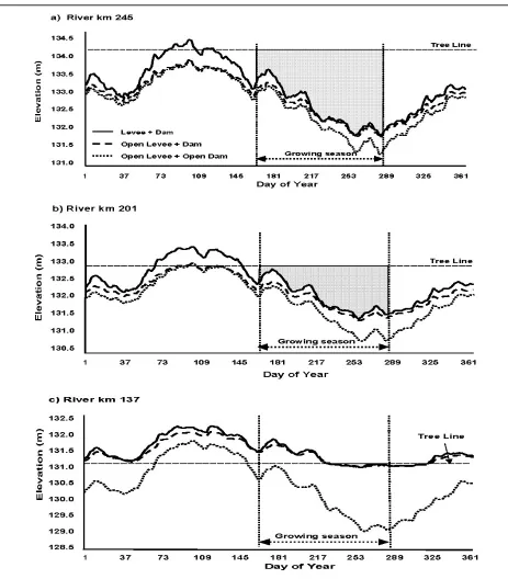
Figure 3. Simulated mean daily water levels at three locations in the LaGrange Reach of the Illinois River, under three scenarios: 1) current conditions, with agricultural levees closed to the river and dams operated to maintain navigation depths; 2) agricultural levees open to the river and dams operated to maintain navigation depths; and 3) levees open and the water level control wickets lowered at the downstream navigation dam (dam open). The shaded grey area indicates the range of floodplain elevations under current conditions where moist-soil plants could grow (below the tree line and above the water line). Near the downstream dam (3c), there are no suitable elevations for moist soil plants under current conditions – the tree line is at the low water elevation. The growing season for moist soil plants extends from 15 June to 15 October. Flow data for the UNET hydraulic model were obtained for 20 rep
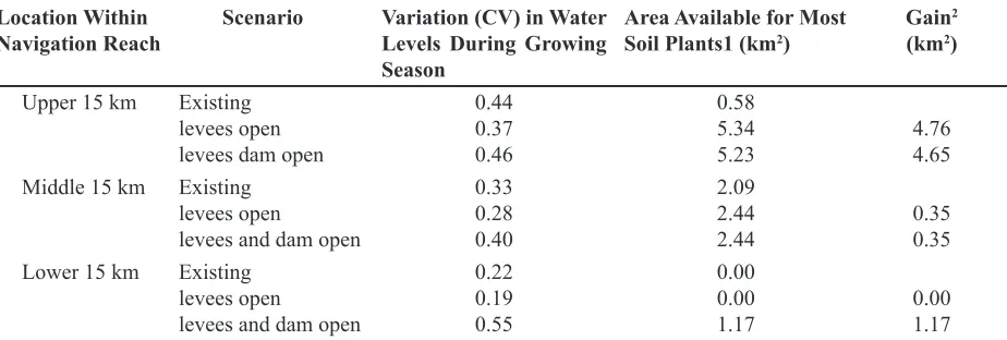
Location Within
Navigation Reach Scenario Variation (CV) in Water Levels During Growing Season
Area Available for Most
Soil Plants1 (km2) Gain 2
(km2)
Upper 15 km Existing levees open levees dam open
0.44 0.37 0.46
0.58 5.34
5.23 4.764.65 Middle 15 km Existing
levees open
levees and dam open
0.33 0.28 0.40
2.09
2.44
2.44 0.350.35 Lower 15 km Existing
levees open
levees and dam open
0.22 0.19 0.55
0.00 0.00
1.17 0.00 1.17
The area above the low water line and below the elevation of the tree line where moist soil plants can germinate, grow, and set seed in four out of ten years, on average (i.e., probability of success in any given year = 40%). Difference between the area currently available for moist soil plants and what would be available under two scenarios: (1) if levees were opened, and (2) if levees and the downstream navigation dam were opened.
1.
2.
Table 1. Variation in water levels (coefficient of variation, CV) and predicted floodplain area (km2) of moist-soil plants under three scenarios at three locations in a navigation reach of the Illinois River.
2. New, Biologically Meaningful Hydrologic
Parameter
For a given year’s hydrograph of daily river stages, the plant model was run many times as the elevation of the simulated growing site was lowered at 10-cm intervals until the model predicted that less than 90 percent of the maximum potential biomass would be produced by the end of the growing season (i.e., “success” equated to 90-100 percent of maximum production potential, see Ahn et al. 2004b). This step-wise process allowed us to determine, for each year, the lowestelevation
at which moist-soil plants were successful. That lowest successful elevation became, in effect, an annual hydrologic parameter (like “maximum daily flow,” or “7-day low flow”).
Repeating this process for 47 years of daily river stages (1946-1993) since the modern dams became operational (in 1940) provided us with a historical distribution of the lowest successful elevation parameter. This distribution enabled us to employ frequency analysis, a commonly used technique in hydrology (Chow 1964), to estimate the probability of plant success at a given elevation in the future (Ahn et al. 2004b).
3. A Surprising Result
Ahn et al. (2006) calculated the area (km2)
where moist soil plants were expected to germinate and grow successfully in four years out of ten (40 percent probability of success in any given
year). Areas were calculated in three 15-km subsections of the study reach (upstream, middle, and downstream) under three conditions: existing (with levees and the downstream dam in place); with levees open; and with both levees and the downstream dam open (Table 1). The greatest gain in area with the levees opened occurred in the upstream subsection, farthest from the influence of
the downstream dam. There was a slight gain in
the middle section. To our initial surprise, there was no area available for moist soil plants in the downstream section under existing conditions and no gain with the levees opened.
Part of the explanation was that the downstream
navigation dam maintained the water elevations at an unnaturally high elevation during the growing
season, permanently inundating the former moist soil plant zone (Figure 3, bottom panel). The range of variation in water levels was much less, compared to what it would have been without the dam and also compared to existing conditions in the middle and upper subsections of the study reach (Figure 3). The coefficients of variation in
water levels during the growing season were much
13
Naturalization of Developed Floodplains
moist soil zone, it apparently now stabilizes the
water levels early enough in the growing season
and to such an extent that trees now grow down to the low water elevation, thereby excluding moist soil plants (Ahn et al. 2006).
4. Applications
Our findings have implications for natural resource managers and for the Corps of Engineers, which operates the navigation dams and which also has new Congressional authority for protection and restoration of the river environment. Location, in relation to navigation dams, is important. Without modifications in dam operations, a reconnected wetland located just upstream of the dam could grow a bottomland forest, but not moist soil vegetation. Fortunately for The Nature Conservancy, which purchased the Emiquon area prior to our research, floodplains near the middle of the navigation reach have the potential to support a diversity of plant communities, including moist soil vegetation (one moist-soil plant, the decurrent false aster, Boltonia decurrens, is a federally-listed species whose center of population is the Illinois Valley). However, the subsection with the greatest potential for moist-soil vegetation, according to our analyses, was the upstream subsection, farthest from the downstream dam. Three papers resulting from our project are cited extensively in the U.S. Army Corps of Engineers’ Illinois River Basin Restoration Comprehensive Plan and Integrated Environmental Assessment and this plan includes proposals for naturalization of the water regime and restoration of moist-soil vegetation (Sparks et
al. 1998, Sparks et al. 2000, Koel and Sparks 2002, USACE 2006).
The Nature Conservancy engaged our researchers to assess reconnection of the Emiquon
area in greater detail, with the result that a
managed connection to the river (through gates in the levee) is now regarded as the preferred option. The Conservancy will attempt to naturalize the water regime within the levees, by admitting water from the river during the spring and excluding the unnatural, small fluctuations that occur in
the river during the growing season. The natural
recession of the spring flood will be mimicked by
draining water through the gates when the river is
low enough. The existing drainage pumps might be used, if the river does not drop low enough for drainage by gravity.
Knowing that Emiquon had the potential to support diverse plant and animal communities, particularly with a managed connection to the river, we decided to make Emiquon and the adjacent communities a subject of the last step in our study: an analysis of local economic effects of conversion of agricultural lands back to floodplains.
Importance of Scale: Economic
Impacts of Floodplain Naturalization
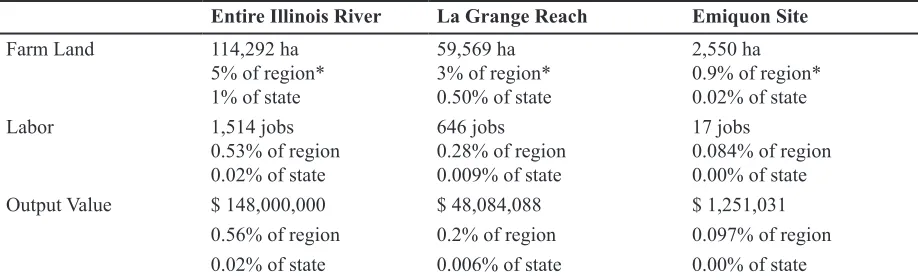
The economic impacts of removing agriculture from the floodplain are very small at both the regional and state-wide scales, because the proportion of the labor force and economic output (in dollars) that are in the floodplain are so small, much less than 1 percent (Table 2). However, at the local scale, there are important economic impacts
Entire Illinois River La Grange Reach Emiquon Site
Farm Land 114,292 ha
5% of region* 1% of state
59,569 ha 3% of region* 0.50% of state
2,550 ha 0.9% of region* 0.02% of state
Labor 1,514 jobs
0.53% of region 0.02% of state
646 jobs 0.28% of region 0.009% of state
17 jobs
0.084% of region 0.00% of state
Output Value $ 148,000,000 $ 48,084,088 $ 1,251,031
0.56% of region 0.2% of region 0.097% of region 0.02% of state 0.006% of state 0.00% of state
* Region varies with the scale of the analysis. For Entire Illinois River, region is 13 counties. For the La Grange Reach, region is 7 counties. For Emiquon site, region is 2 counties.
to be considered.
School districts, fire protection districts, park districts, drainage districts, and townships and villages that maintain roads and provide police protection are local entities that would be dramatically affected if a farm the size of the Emiquon site were removed from the tax base. To compensate the local districts for loss of tax revenue, it is an administrative policy, but not a legal requirement, of both the U.S. Fish and Wildlife Service and The Nature Conservancy to continue payments to local districts, in lieu of taxes, when lands are purchased and converted. In addition, some, but not all the jobs and output value associated with the former farm would be replaced by jobs and outputs related to management of the naturalization site (Table 3). The site might also generate recreation-based employment. We used the IMPLAN (1999) model to estimate potential consequences of the conversion. Replacement of low-labor farming with land management and recreational employment has the potential to turn the loss into a substantial gain, but requires planning and prioritization of sites to promote recreational development (Table 3).
Summary
Reducing future flood damages and restoring natural services provided by floodplains is not as simple as buying levee districts from willing sellers and then breaching the levees. Removing agriculture from the floodplain can have a significant negative impact on the local economy,
unless outdoor recreation, tourism or other
activities are developed that are compatible with the naturalized floodplain. The value of the area for these activities depends in turn on the quality of the naturalization. We evaluated the potential for naturalization using a simulation model for an indicator group of plants, the moist-soil plant community, that depends on the natural flooding cycle and provides food and shelter for a variety
of valued species. Existing conditions and two alternative scenarios were evaluated by analyzing the frequency of successful growing seasons for moist soil plants using a 47-year record of daily water levels and a hydraulic simulation model (for the scenarios). Results were expressed as color-coded probabilities of plant success overlain on 3-D maps of the floodplains–a visualization of results that was readily understood by stakeholders.
One of the stakeholders, The Nature Con-servancy, subsequently funded a more detailed study by our scientists of the Emiquon Floodplain Restoration Project, a 2,125-ha agricultural drainage and levee district purchased for $18.3 million in 2000 by the Conservancy and located
within our study reach on the Illinois River. Based
on the results, the Conservancy plans to undertake a managed reconnection of the river and the floodplain at Emiquon, using gates in the levee to admit river water (and aquatic organisms) during the spring flood, but to exclude the unnatural, frequent summer floods that drown moist-soil plants. The Conservancy intends the Emiquon Restoration to be a model not only for its floodplain restorations in the Upper Mississippi River Basin, but also a model for naturalization projects undertaken by state and federal agencies. Three papers from this project are cited extensively in the U.S. Army Corps of Engineers’ Illinois River Basin Restoration Comprehensive Plan and Integrated Environmental Assessment and the plan includes recommendations for naturalizing the hydrology of the river and restoring moist-soil vegetation (USACE 2006).
The results from the project are also used in an introductory lecture for summer interns at the National Great Rivers Research and Education Center and have been the basis of the development of an economic module for the NSF curriculum development project on Interdisciplinary Modeling of Aquatic Ecosystems (Saito et al. 2005). Our co-PIs and project information were among the
Farming
Eliminated Refuge Management Refuge with Recreation Potential Net Change
Land - 2,550 ha 2,550 ha 2,550 ha 2,550 ha
Labor - 17 jobs 10 jobs 66 jobs + 49 jobs
Output Value $ - 1,251,031 $ 500,000 $ 3,280,000 $+ 2,028,969
15
Naturalization of Developed Floodplains
resources used by graduate students in a project in Urban and Regional Planning at the University of Illinois to: (1) analyze the evolution of planning efforts on the Illinois River; (2) compare these efforts to planning efforts elsewhere; and (3) develop a framework for improved, integrated planning for the Illinois River (Fassero et al. 2001).
Acknowledgments
The study was supported by two grants from the National Science Foundation (NSF DEB-9613562 and BCS-0003208) on behalf of all NSF, USEPA, and US Department of Agriculture units participating in the special joint competition on Water and Watersheds research and by the Illinois Chapter of The Nature Conservancy. The following contributed to the project and to the papers on which this summary is based, between 1996 and 2006: C. Ahn, D. Beal, M. Demissie, Y. Lian, A. Isserman, D. Johnston, Z. Nedovic-Budic, D.W. Schneider, and D. White. Matt Joost and Cathy Truong contributed under the NSF Research Experience for Undergraduates (REU) program. We thank the following research associates and graduate research assistants: William Brown, Jason Casanova, Tarun Chandrasekhar, Ariaster Chimeli, Barbara Frommel, Paul Fyle, Amenu Geremew, Raymond Kan, Jungik Kim, Da-Mi Maeng, and Diane Timlin. This is contribution number 16 from the National Great Rivers Research and Education Center, Alton, Illinois and 240 from the Illinois Water Resources Center, Urbana, Illinois. We thank Ruth Sparks, and the reviewers and the editors of this issue of JCWRE for improving the manuscript.
Author Bios and Contact Information
richard sParKs, (Ph.D.) is Director of Research,
National Great Rivers Research and Education Center, Alton, Illinois, which is a partnership of the University of Illinois at Urbana-Champaign, Lewis and Clark Community College, the Illinois Natural History
Survey, and several other institutions concerned with management, education, and research on rivers and
watersheds. He formerly directed the Illinois Water Resources Center and remains affiliated with the Illinois Natural History Survey where he directed the Large River Research Program on the Upper Mississippi
River system. Address: National Great Rivers Research and Education Center, 5800 Godfrey Road, Godfrey, IL 62035. Email address: rsparks@uiuc.edu.
John Braden, (Ph.D.) is Professor and Director of
Undergraduate Programs, Department of Agricultural and Consumer Economics, University of Illinois at Urbana-Champaign. He formerly directed the Illinois Water Resources Center and the Environmental Council of the UIUC, and also served as Associate Provost of the University. Address: University of Illinois, 1301 W. Gregory Drive, Urbana, IL 61801. Email address: jbb@
uiuc.edu.
References
Ahn, C., D. M. Johnston, R. E. Sparks, and D. C. White. 2006. Analysis of naturalization alternatives for the recovery of moist-soil plants in the floodplain of the
Illinois River. Hydrobiologia 565: 217-228. Ahn, C., K. F. Moser, R. E. Sparks and D. C. White.
2007. Developing a dynamic model to predict the recruitment and early survival of black willow (Salix nigra) in response to different hydrologic conditions.
Ecological Modelling, 204(3-4): 315-325.
Ahn, C., R. E. Sparks and D. C. White. 2004a. A dynamic model to predict responses of millets (Echinochloa sp.)to different hydrologic conditions for the Illinois floodplain-river. River Research and Applications
20(5): 485-498.
Ahn, C., D. C. White and R. E. Sparks. 2004b. Moist-soil plants as ecohydrologic indicators for recovering the flood pulse in the Illinois River. Restoration Ecology 12(2): 207-213.
Akanabi, A. A., Y. Lian, and T. W. Soong. 1999. An analysis on managed flood storage options for selected levees along the lower Illinois River for enhancing flood protection. Report No. 4: Flood Storage Reservoirs and Flooding on the Lower
Illinois River. Illinois State Water Survey Contract Report 645. Illinois State Water Survey, Watershed
Science Section: Champaign, IL.
Changnon, S. A. (ed.) 1996. The Great Flood of 1993: Causes, Impacts, and Responses. Westview Press, Inc.: Boulder, CO, 321pp.
Chow, V. T. 1964. Statistical and Probability Analysis of Hydrologic Data. Section 8-I in Chow, V.T. (ed.)
Handbook of Applied Hydrology. McGraw-Hill, Inc.: New York, NY.
Fassero, C., B. Frommell, P. Knauss, and R. VanderKelen. 2001. Planning for the Illinois
Project Report, Department of Urban and Regional Planning, University of Illinois: Urbana, IL. 58pp. 2 appendices.
HEC. 1993. One-dimensional Unsteady Flow Through a Full Network of Open Channels; User’s Manual. U.S. Army Corps of Engineers, Hydraulic Engineering Center: Davis, CA.
IMPLAN. 1999. IMPLAN Users Guide. Minnesota IMPLAN Group, Inc.: Stillwater, MN. Available at http://www.implan.com.
Interagency Floodplain Management Review Committee. 1994. Sharing the Challenge: Floodplain Management into the 21st Century. U.S. Government Printing Office: Washington, DC.
Koel, T. M. and R. E. Sparks. 2002. Historical patterns of river stage and fish communities as criteria for operations of dams on the Illinois River. River Research and Applications 18(1): 3-19.
Reuter, M., K. Lubinski, P. West, D. Blodgett, and M. Khoury. 2005. The Nature Conservancy’s approach to conserving and rehabilitating biological diversity in the Upper Mississippi River system. Archiv für
Hydrobiologie Supplement 155/1-4: 521-538.
Rhoads, B. L. and E. E. Herricks. 1996. Human-induced change in low energy agricultural streams: An example from east-central Illinois. Pages 968-973 in A. Brookes and F.D. Shield (eds.) River Channel Restoration. Wiley: Chichester, UK
Saito, L., H. Segale, and G. Neuberger. 2005. Interdisciplinary Modeling of Aquatic Ecosystems Curriculum Development Workshop. Lake Tahoe, CA, July. Available at http://swiki.dlese.org/ aquamod/1.
Sparks, R. E. 1995. Need for ecosystem management of large rivers and their floodplains. BioScience 45(3): 168-182.
Sparks, R., C. Ahn, M. Demissie, A. Isserman, D. Johnston, Y. Lian, Z. Nedovic-Budic, and D. White. 2005. Linking hydrodynamics, conservation biology, and economics in choosing naturalization alternatives for the Illinois River, USA. Archiv für Hydrobiologie Supplement 155/1-4: 521-538.
Sparks, R. E., J. B. Braden, M. Demissie, P. Mitra, D. W. Schneider, D. C. White and R. Xia. 2000. Technical support of public decisions to restore floodplain ecosystems: A status report on the Illinois River project, USA. Pages 225-247 in A. J. M. Smits, P. H. Nienhuis and R. S. E. W. Leuven (eds.)
New Approaches to River Management. Backhuys
Publishers: Leiden, The Netherlands.
Sparks, R. E., J. C. Nelson, and Y. Yin. 1998.
Naturalization of the flood regime in regulated rivers: The case of the Upper Mississippi River. BioScience
48(9): 706-720.
Thompson, J. 2002. Wetlands Drainage, River
Modification, and Sectoral Conflict in the Lower
Illinois Valley, 1890-1930. Southern Illinois
University Press: Carbondale, IL. 284 pp.
Upper Mississippi River Conservation Committee (UMRCC). 2000. A River That Works and a Working
River. UMRCC: Rock Island, IL.
U.S. Army Corps of Engineers (USACE). 2006. Illinois River Basin Restoration Comprehensive Plan with Integrated Environmental Assessment. Public Review Draft, February 2006. Rock Island District, USACE: Rock Island, IL.
White, G. and M. F. Myers (Eds.), 1994. Coping with the flood: The next phase. Water Resources Update