Orienteering
This factsheet updates and replaces
'Orienteering in theScout Troop' PT-5811988 and 'Clockface Orienteering'RES-14 1987.
Further editions will be published as necessary. The issue of replacement factsheets will be notified in SCOUTING Magazine and Talking Points.
Introduction
Getting about the countryside with map and compass is a prime Scouting activity. Orienteering is the modern way of becoming proficient in the art. It is true Scouting and should be included in your training programme.
Scouts should excel at finding their way about the countryside, and adult Leaders should excel at teaching their Scouts how to do it. The basic skills are included specifically in the progressive training awards. The Scout Award requires a Scout to complete a simple navigation exercise with map and compass. The Explorer Award develops this feature. Get outdoors and teach orienteering.
Orienteering is map-reading made fun. Scouts like fun and should be good at map-reading, but many adult Leaders perhaps fear that the sport is a specialist activity involving much hard work in its organisation. The purpose of this factsheet is to show that orienteering at Troop level need not be much more than map-reading, and to suggest way by which the hard-worked Leader can practise the Troop in the sport, or in elements of it, without killing off the members.
What is orienteering?
Orienteering is competitive way-finding with map and compass, and the sport is fashioned by mixing together the ingredients of map-reading (the more the better) with some competition rules. The basic ingredients are always the
same and training can be aimed at them specifically. The competition rules are easily learned. Of the many types of orienteering there are only two which need concern you - cross-country and score (see Figs 1 and 2). Your local library will have books on the various forms of orienteering.
Allcontrols must be visited in the order shown, but the lines joining the controls indicate only the general direction to be followed. There is no time limit: the shortest time for visiting all controls in the correct order wins. This is not suitable for large numbers of competitors as an individual staggered start is essential.
Competitors can visit any controls in any order. The controls are lettered. The number against each control is the score for visiting the control. There is a time limit. There is a lateness penalty. The highest net score wins. This is suitable for any number of competitors, as a staggered start by groups is possible.
How can I train my Troop?
The basic map-reading skills are very important, so make a start by giving the Troop small doses on Troop nights. Don't wait until you have covered the whole gamut of map-reading skills before starting the real thing or you may never start at all. As a Scouter your viewpoint should be that orienteering is the best way of training in map-reading, not the other way round.
It is not your intention to produce just a few weekend map-reading athletes, so avoid the temptation to associate your Troop with
orienteering merely by pressing your best Scouts to join a club. Get the whole Troop doing it. Start the new member who hardly knows what a map is by competing in pairs, new member and Patrol Leader together.
They will all find map reading is fun, and through the supplementary training on Troop nights the new Scout will begin to realise what it is all about. A method of training in the sport will be suggested which dispenses with all those red and white markers and course officials, and allows one Scouter (or one parent) to do the lot with such ease that the instructor arrives at, and departs from, the course area at the same time as the Scouts.
What equipment do I need?
Obviously maps and compasses first. The map most suitable and used in many competitions in this country is the 1:25,000 series in four colours. Buy one or two per Patrol. Each sheet covers 30 square miles and make sure your playground is wholly on one sheet and doesn't spill over onto the next (Note that for competitions later you will need black and white reproductions. You will need to get permission from the Ordnance Survey to reproduce their maps).
Buy a plastic map case for each map, an
expensive map can be ruined in one afternoon if not protected.
Chinagraph pencils, cut in half, are needed for marking map cases, never maps.
Compass choice is fortunately very limited. Silva protractor compasses have a virtual monopoly in this field. The Silva 7DNS is quite adequate for beginners. Buy one or two per Patrol to make sets with the maps and covers, and thread a yard of strong twine through each
compass. Insist on the Scouts wearing them round the neck when outdoors.
You have bought all you need for getting your Troop started in orienteering. With one set per Patrol and four Patrols you will never regret this expense.
For preliminary training indoors in bearings Silva practising compasses and protractors are useful low cost extras to supplement your small stock of proper compasses. For measuring bearings on the map the practice is as good as the real thing, and a 360° paper protractor gives new Scouts a good understanding of the subject and is useful for checking answers obtained with a compass. You may well decide to buy one for every two Scouts in the Troop and keep your proper compasses for field use.
An attractive instruction tool guaranteed to hold the new Scout's interest is a Silva demonstration compass, a king-size version of the practising compass for blackboard use.
How can I practise the Troop in orienteering skills?
Each problem on the ground is the balancing of accurate map-reading against time. One must be sacrificed to some extent in the interests of the other, but hasten slowly at first. What Scouter is not saddened by the sight of a Scout who takes a quick and wholly inadequate look at the map and moves off at speed in precisely the wrong direction ?
Here are a few suggestions in the basic orienteering skills of familiarity with maps and quick accurate grid references.
Map search quiz
cultivates an air of excitement by setting a fast pace for the questions and gives the running score after every few points. Small prize for the winning Patrol.
Grid reference relay race
Map a map code chart about 3 feet square, from hardboard, as shown at Fig 3. The 'map' is gridded at 6 inch intervals, and the 'features' are letters - there is no other detail. The same chart can be used time and time again for the training of new Scouts, so you may try to commission the Troop artist to produce a neat painted job with red letters, black grid lines, and numbers, and coat it in clear varnish to keep the paint on and the weather off.
Select a suitable location for the hidden treasure (it is essential to have real treasure) and make up a short message of a dozen letters or so to form a clue to the location, for example 'THE SCOUTER'S BAG'. Encode the letters into grid references and provide a set of slips of paper for each Patrol with a grid reference and a blank box on each one. Set up at a short distance from the headquarters and arm each Patrol with a pencil to use as a relay baton and for writing letters in the boxes. Scouts run with one slip at a time and on their return pass the baton to the next Scout and the slip to the Patrol Leader who, assisted by the Patrol decodes the message (Fig 4).
The order of issue slips can be straight or mixed but should be the same for all Patrols. If it's practicable, bicycles add much to the excitement but the distance should be doubled. It will be noted that the chart is designed to compel Scouts to remember ‘Eastings before Northings'. If, for example, the grid reference 645630 is read with Northings first, X is obtained instead of the important letter B, with disastrous results for the Patrol concerned and for the Scout who has let it down.
Compass work, bearing and distance
Preliminary bearing exercise (indoors)
Give to each Scout or pair of Scouts
• 'map sheet' made out as shown in Fig 5 but without the dotted lines. Identical position can be easily assured by pricking through the sheets with a pin. The grid spacing is
unimportant but the distance between control points should be such that a Silva compass will span the longest leg.
• a Silva compass, or a Silva practising compass.
(Note that the dotted lines are not included on the sheets given to the Scouts)
Set problem of this type: 'You are at control point No 1 and intend to go to control No. 2. Without using your compass or protractor what
approximate magnetic bearing should you travel on? Now measure the bearing using the
compass, and check your answer with the circular protractor. '
The outside legs -1 to 2, 2 to 3, etc., are very easy starters to put over the ideas to the new Scout. The older Scouts will quickly spot that measurement is unnecessary. But even the Patrol Leaders will have to measure the bearing off, say 2 from 4 or 3 from 6.
It is very important that a Scout should first decide the approximate bearing before using the compass. If subsequently a ridiculous answer is obtained the Scout will know that the compass has been placed on the map the wrong way round, looked at the wrong arrow or made some other basic error that would bring quick
retribution on the ground. There is another very good reason for making this approximation in practice. It is often all that is needed to decide a certain course of action. The orienteer who spends time producing accurate answers on all occasions will seldom appear on the prize list.
Bearing and distance treasure hunt
Two teams compete for one treasure. This requires open country or heathland with clear distances of 100-200 metres between controls. Two courses are plotted with a common start and finish, the same number of legs, and
approximately the same total distance of about half a mile (see Fig 6).
The treasure can be buried in a jam jar under a stone or a tent peg. Place a camp shovel near each of the last two control points before the treasure. It is best if the control points are features such as bushes, track junctions and the like. They can then be described on the course cards (reproductions of the two halves of the figure) and they will probably still be there next year when other new Scouts try out their skill. If no suitable features are available then you will have to put down temporary markers such as tent pegs. It is essential to have something recognisable, as each fresh leg must start from an accurate known position. Accumulative errors will otherwise put the Scouts too far away from the treasure at the finish. The treasure must be found by the team clever enough to get there first.
Clockface orienteering
Orienteering competitions usually cover a wide expanse of varied countryside. However, elementary compass practice can be provided in a number of ways on a much smaller piece of ground. One very simple training method is that of 'clock-face' orienteering. This is based on the fact that any two of the 'hour' positions of a clock face can be located, from each other, by means of the basic geometry of the layout.
bearings at intervals of 30ø, 60ø, 90ø, etc. to 360ø.
The tent pegs (or other markers) should be inserted into the ground in such a way that they are not readily visible from a distance of more than (say) two yards. They should be identified by a letter - preferably in a random fashion so that the sequence is not too obvious to those taking part in the game.
In addition two other marker pegs should be positioned at some known distance apart, e.g. 25 yards, in order that the competitors can check the length of their pace prior to setting off on the course. This should preferably be located away from any of the pegs used to mark the playing circle.
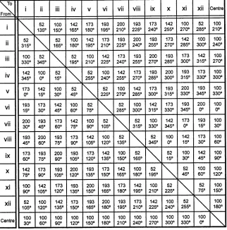
This layout can then be used to devise an almost infinite number of orienteering courses, ranging from a simple shape (such as a parallelogram) to a complex zigzag, by means of the 'ready reckoner' table shown on the last page.
This quotes the distance and bearing between all possible pairs of points for a circle of radius 100 feet, with twelve o'clock at due North from the centre. Hence, a typical nine stage course could be devised as follows:
1. Take point 1 (1 o'clock) as the start.
2. Draw each stage of the course on a circle (Fig 7) taking care to use stages of various lengths.
3. Number each stage in sequence on this plan.
4. Obtain the bearing and distance details from the appropriate squares from the clock-face
'ready reckoner' (Fig 10) and insert these in the chart (Fig 8)
5. List these route details in a single column, as instructions for each competing team, with a request that they should indicate the identification letter of each marker. These can then be compared with the Scouter's original route lists in order to check that each team followed the correct sequence of marker points
The convenience of the arrangement hinges round the use of the 'ready reckoner' table since it enables the course details, and instructions, to be worked out in advance (provided the radius of the circle is known): whilst the clock face can, if necessary, be laid out later (e.g. immediately prior to a Troop Meeting).
Magnetic or Grid?
Before leaving bearings a word of advice on converting from one to the other. The difference of 8' or so is too large to ignore, certainly in the early days when Scouts will not know when they can safely do so. The mechanics of conversion are simple anyway and can be taught thus:
Don't say add or subtract - just say that the magnetic bearing is always bigger, and the rest follows
Mental alertness and quick decision
Map route selection
Map sheet for each pair of Scouts. 'You are at ... and must go to ... You have one minute to choose the best route.' Take answers from one or two pairs only, and set up a general
discussion.
Twenty questions
The night before the Troop meeting spend an hour touring the area within half a mile of Headquarters. Then put 20 questions on the blackboard, such as:
1. Who wrestles with the Iron Man of the North next week at the Civic Hall?
2. Who is the landlord of the King's Head?
3. What time does the last 408 bus leave the market on Sunday?
Questions are always deliberately mixed up with regard to location. The Patrol Leader has to sort out and delegate areas of operation, then be first back to record answers; 40 minutes time limit if on foot; 20 minutes with bikes.
Recognition of the ground from the map
Route forecasting
Map sheet for each pair of Scouts. 'You are at... and moving along the track in the direction of ... Describe the route as you go along, saying just what you would expect to see. Give distances always, and approximate bearings off all prominent features that are well back from the 'track' .
Car rally
Parents drive. Scouts navigate. Brothers and sisters are invited and parents bring a picnic tea. 15-20 miles over secondary roads at very modest speed, answering simple questions to prove route faithfully followed, such as: 'Pillar box at ... What time is the Sunday collection?', 'Northbridge Farm-How much a dozen are new laid eggs?' Points for getting correct answers. Deductions for lateness at picnic rendezvous (but give plenty of time in the interests of safety). Prizes for winning family and runners-up.
How can I practise the Troop in orienteering proper?
You must accept right away that orienteering competitions, even at Troop level, are not Friday night subjects.
You may be lucky enough to have a Youth Officer in your area who organises competitions from time to time. If so, enter your Troop at once for the next event - as many Scouts as possible - as there is sure to be a class for beginners. if you are unlucky here, seek out your nearest orienteering club through the regional secretary, and go along as an observer at their next event. You will gain a valuable insight into the accepted procedures and can organise your Troop training on the right lines.
If you are unable to join in any competitions run by other people, it is quite easy to run your own. Adapt a compromise method that has all the ingredients of the real thing, but cuts a great deal of time, labour and expense. Just don't bother with all those red and white markers!
that give the Troop Scouter a headache. The entire course has to be run or walked just before the event putting them out and then the markers need to be collected after the event - and even a short course for Scouts is three miles or so. Furthermore, the attractive colouring of the markers makes them collectors pieces -'Mummy, look what I found growing in the woods' - and a missing control can ruin a cross-country event. The markers are not exactly cheap, and you will need at least a dozen markers and stamps for a score competition .
Question and answer
You want easy recognition and proof of finding, so all you need to do is to choose a definite feature and ask a question about it, e.g.
• A five-barred gate: What does the notice say?
• A telegraph pole: What is the number of it?
• A signpost 5« miles to where?
A correct answer is accepted proof that the control was found.
You must, of course, select country having these features, and they must be unambiguous - there must be only one gate or telegraph pole or signpost. It might be thought that this sadly limits the type of terrain that can be used, but in practice it will be found that most natural countryside has sufficient track junctions, gates, stiles and the like to supply all the controls needed. True, the actual way-finding is simplified, but this is no disadvantage for beginners and the method can be used over farm areas, villages, and even towns, where the usual markers are both unsuitable and risky to put out.
It should be easy in competitions within the Troop to insist upon and obtain one hundred per cent compliance with the Scout Law - no copying or giving away answers - but it must be admitted that in inter-Troop events run by this method there is temptation to help out one's own team mates at times. For Troop training, however, the advantages of the method far outweigh the disadvantages. The Scouts have fun running around answering the questions. The Scouter has fun running around setting them and will be
very gratified with the marked progress in map-reading that the Scouts will exhibit after just a few months of this delightful sport. Orienteering is indeed map-reading made fun
Equipment
• Silva compasses - Type 7DNS for beginners, other models with advanced features for more advanced navigators. Silva practising compass and protractor. Silva perspex demonstration compass or a blackboard demonstration compass.
• Truefit angle indicator
• Techometer (pace counter) can be fitted to your Type 4 Silva compass
• Control markers, red and white plastic
• Control marker punches
• Set of 10 letters or figures
• Map cases, clear plastic, zip closure,
• Competition cards
• Simple compass game - Silva system
• Start Orienteering Kit - British Orienteering Federation.
Useful addresses
Scout Shops Limited, Lancing Industrial Estate, Lancing, West Sussex BN1 5 BUG.
British Orienteering Federation, 'Riversdale', Dale Road North, Darley Dale, Matlock, Derbyshire DE4 2JB.
Ordnance Survey, Romsey Road, Maybush, Southampton S09 4DH.
Clock-face ready reckoner
centre. The upper figure in each square represents the distance (in feet) and the lower figure bearing (in degrees) between the points -taking the horizontal rows as giving the starting point.
For example, to find the data for a journey from 4o'clock to 3 o'clock, find the horizontal row marked IV and then the vertical row marked III in the chart - the figures in the square for which
these intersect then give the route details (i.e. a distance of 52 fton a bearing of 150).