University of New Orleans University of New Orleans
ScholarWorks@UNO
ScholarWorks@UNO
University of New Orleans Theses and
Dissertations Dissertations and Theses
12-15-2007
Sugar Hill: Architectural, Cultural and Historic Significance of an
Sugar Hill: Architectural, Cultural and Historic Significance of an
Early Twentieth Century African American Neighborhood in New
Early Twentieth Century African American Neighborhood in New
Orleans, Louisiana
Orleans, Louisiana
Niala Lynn Howard University of New Orleans
Follow this and additional works at: https://scholarworks.uno.edu/td
Recommended Citation Recommended Citation
Howard, Niala Lynn, "Sugar Hill: Architectural, Cultural and Historic Significance of an Early Twentieth Century African American Neighborhood in New Orleans, Louisiana" (2007). University of New Orleans Theses and Dissertations. 617.
https://scholarworks.uno.edu/td/617
This Thesis is protected by copyright and/or related rights. It has been brought to you by ScholarWorks@UNO with permission from the rights-holder(s). You are free to use this Thesis in any way that is permitted by the copyright and related rights legislation that applies to your use. For other uses you need to obtain permission from the rights-holder(s) directly, unless additional rights are indicated by a Creative Commons license in the record and/or on the work itself.
Sugar Hill:
Architectural, Cultural and Historic
Significance of an Early Twentieth Century African American Neighborhood in
New Orleans, Louisiana
A Thesis
Presented to the Graduate Faculty of the University of New Orleans in partial fulfillment of the requirements for the degree of
Master of Science in
Urban Studies
by
Niala Lynn Howard
B.G.S., University of New Orleans, 2003
Table of Contents
List of Tables ... iv
List of Figures ...v
Abstract ... vii
Preface... viii
Chapter 1: Introduction ...1
Purpose and Scope ...2
Limitations ...6
Criteria A, B, C, D ...6
Methodology ...8
Chapter 2: Review of Literature ...10
Early Preservation Efforts...10
How Areas Become Historic Districts...11
National Register Historic Districts in New Orleans...12
The National Preservation Act of 1966 ...13
The National Register of Historic Places...14
Chapter 3: The Making of a Neighborhood ...17
Early Neighborhood Development ...17
Dillard University ...32
Camp Leroy Johnson ...35
The Decline of Sugar Hill ...37
Chapter 4: Physical Boundaries ...40
Chapter 5: Architectural Development ...50
Chapter 6: Architectural Significance ...58
Surveyed Architectural Styles and Properties...62
Alden Daste House ...62
Conrad Rein House ...65
Arthur Richard House ...68
Chapter 7: Cultural Significance...71
Culturally and Historically Significant Properties...72
Andrew Jackson Young Jr. House ...72
Prudhomme Dejoie House ...80
Rivers Fredericks House ...82
St. John Berchmans Manor ...87
C.C. Dejoie House ...95
Israel Augustine House ...99
Chapter 8: Analysis and Conclusion...104
Strengths ...104
Weaknesses ...105
Conclusion ...105
List of Tables
List of Figures
Figure 1. Evaluated subsection of Sugar Hill ...3
Figure 2. Judge Martin and Darcantel Plantation ...17
Figure 3. Topographic cross section of New Orleans...18
Figure 4. Judge Francois Xavier Martin ...19
Figure 5. Tourists Cottages ...20
Figure 6. The Paving of Gentilly Boulevard...21
Figure 7. Favorable paved routes in New Orleans...22
Figure 8. Diary cow on Neutral Ground ...23
Figure 9. Evidence of Dairy Farms...23
Figure 10. Detailed Street Map of the entire Sugar Hill Neighborhood...24
Figure 11. Baldwin Wood Screw Pump ...27
Figure 12. Early Neighborhood Development...29
Figure 13. St. John Berchmans in 1938 ...30
Figure 14. Sugar Hill’s population from 1927-1937 ...30
Figure 15. Sugar Hill’s population from 1939-1951 ...31
Figure 16. Dillard University...32
Figure 17. Camp Leroy Johnson...35
Figure 18. Army Barracks located on the Municipal Square 1965...37
Figure 19. Area removed for construction of Interstate 610 ...38
Figure 20. Area removed for construction of Interstate 610...39
Figure 21. Outlined Boundaries of Target Area ...41
Figure 22. Indigenous Trees ...43
Figure 23. Pauger Street Southern View...44
Figure 24. Live Oak Place ...44
Figure 25. Current image of Live Oak Place ...45
Figure 26. Trail along Bayou Savage ...46
Figure 27. Prior 20th Century Development...51
Figure 28. Double and Single Shotgun ...53
Figure 29. Streetscape of Double Shotguns...54
Figure 30. One of the neighborhoods oldest structures ...54
Figure 31. One of the neighborhoods oldest structures ...55
Figure 32. Typical WWII Cottage ...55
Figure 33. Typical WWII Cottage Floor Plan ...56
Figure 34. Contributing Properties ...58
Figure 35. Bracketed shotgun ...60
Figure 36. Early Arts and Crafts ...60
Figure 37. 3400 block of New Orleans...61
Figure 38. English Cottage ...61
Figure 41. Daste Home ...63
Figure 42. Conrad Rein Home ...66
Figure 43. Sister Mary Conrad A. Rein ...68
Figure 44. Arthur Richard Home ...69
Figure 45. Andrew Jackson Young Home...73
Figure 46. Photo of Andrew J. Young ...76
Figure 47. Photo of Walter Fuller Young ...78
Figure 48. Prudhomme Dejoie Home ...81
Figure 49. Rivers Frederick Home...83
Figure 50. Photo of Rivers Frederick Junior High School...86
Figure 51. Photo of Louisiana Life ...87
Figure 52. St. John Berchman Manor ...88
Figure 53. Photo of Thomy Lafon ...90
Figure 54. Photo of The Sisters of the Holy Family ...90
Figure 55. Photo of Mother Superior Mary Elizabeth ...91
Figure 56. Parapet on St. John Berchman...93
Figure 57. 1891 Cornerstone on St. John Berchmans Manor ...94
Figure 58. 1925 Cornerstone on St. John Berchmans Manor ...95
Figure 59. Photo of Henriette Delille...95
Figure 60. Photo of Original Sisters of the Holy Convent...95
Figure 61. Constance Charles “C.C.” Dejoie Home...96
Figure 62. Photo of C.C. Dejoie ...98
Figure 63. Unity Insurance Company Advertisement ...100
Figure 64. Israel Augustine House...101
Figure 65. Photo of Israel Augustine ...103
Figure 66. Photo of Israel Augustine Justice Center ...104
Abstract
Across the United States, efforts are being made to document African American history
and its contribution to the development of this country. At all levels of government and through
individual research, attempts are being made to recognize and pay tribute to the role of the Black
American. These efforts involve documenting the architectural, cultural, historical, scientific,
and social contributions. In New Orleans, the Black American played a major role in the
development of the city. For most of the 20th century, African Americans have been the
majority of the population. However, little has been done to document their rich architectural and
cultural contributions.
This thesis involves original research on the architectural, cultural and historic
significance of the properties in the Sugar Hill neighborhood of New Orleans. This
research will be used to determine if this neighborhood meets the National Park Service’s criteria
to be recognized as a National Register District.
Preface
The idea of researching the Sugar Hill neighborhood intrigued me because there was little
information readily available. I learned about the neighborhood from Annie Avery, who was the
director of the African American Heritage Program at the Preservation Research Center. She had
great things to say about the neighborhood. However, upon numerous searches, most
information about the neighborhood merely stated that this area served as a hub for African
American doctors, lawyers and teachers. I wanted to know who these people were, and decided
in early 2005 to research this area by gathering oral histories from residents. I began by
frequently driving the neighborhood taking pictures, conducting spontaneous interviews, and
attending neighborhood meetings. The spontaneous interviews provided a wealth of information
about the neighborhood and the residents. I documented these interviews with recordings and
field notes. On August 28, 2005 when fleeing Hurricane Katrina, I decided to leave without any
of my research. I had at least 8 feet of water in my residence and as a result I lost everything.
Since then I have lived in numerous places, enrolled in two other graduate schools, but I kept in
touch with the staff from University of New Orleans. I spent the most time in Chicago and
contemplated changing my thesis topic to the Bronzeville neighborhood, an African American
neighborhood in Chicago, Illinois that thrived in the 1920s. In fact State Street, one of the
neighborhood boundaries, was known as the “Black Wall Street” because it was similar in
architecture to its counterpart in downtown Chicago, but businesses were owned by African
Americans. This neighborhood served as home to many who left the South. While jobs were
available, segregation laws forced African Americans to congregate in this neighborhood. It was
information from returning residents. However many residents had passed away, were displaced
or simply were not in the mood to discuss the history of the neighborhood. In December of
2006, I decided to move back to New Orleans to complete my graduate program at the
University of New Orleans. I wanted to continue my research, but the idea of documenting it by
oral history was no longer sufficient. So I decided to evaluate the built environment by
documenting a subsection of the neighborhood using the National Register nomination form.
Chapter 1
Introduction
There are 13,594 historic districts listed on the National Register of Historic Places. One
hundred and five African American historic districts are listed in the United States and its
territories. Louisiana has only two African American historic districts, Dillard University in
New Orleans and St. Joseph Historic District in Tensas Parish. There is an under representation
of African American Historic Districts on the National Register.
In New Orleans, a slow awareness of the contributions of African Americans has been
growing. This was evident before the devastating effects of Hurricane Katrina in 2005. Some
people were heralding the rich contribution of the carpenters, bricklayers, and plasterers, mostly
African American and generally from the city’s Seventh Ward. Since Katrina, the Federal
Emergency Management Agency (FEMA) and the State Historic Preservation Office have
worked to note the Pontchartrain Park neighborhood as National Register eligible. Pontchartrain
Park is the first Black suburb built after World War II, and members of this neighborhood sought
this designation for many years prior to Katrina. It was the devastating floodwaters and the
probable loss of many structures in this low-lying neighborhood that prompted the government
to act. Although, in most instances, New Orleans is seen as a melting pot of cultures where most
neighborhoods have always been racially mixed, historically there are neighborhoods that have
been racially segregated. The Gentilly Sugar Hill neighborhood is important because it has been
predominantly African American from its original development. As a hub of middle and upper
middleclass development since the 1940s, it has been associated with many notable African
Purpose and Scope
The purpose of this thesis is to research the development of the Gentilly Sugar Hill
neighborhood to determine if it has architectural and/or cultural significance sufficient to meet
the National Register District criteria. The entire Gentilly Sugar Hill neighborhood encompasses
a total of 39 municipal squares. Because of the extensive number of properties occupying these
squares, it was necessary to choose a representative subsection of the neighborhood to research
and evaluate. The subsection that was chosen consisted of roughly nine neighborhood squares
with a total of 88 properties. To prove architectural significance each property had to be
evaluated using the New Orleans Historic District Landmark Commission (HDLC) property
evaluation form as a tool. This form is primarily used by the HDLC, however it aided my
research because it is similar to the National Register District criteria and provided a simple
checklist for property evaluations. To prove cultural significance, significant individuals had to
have been affiliated with the property. Of the 88 properties in the subsection, ten of those were
chosen for detailed research. These properties were chosen because of architectural style,
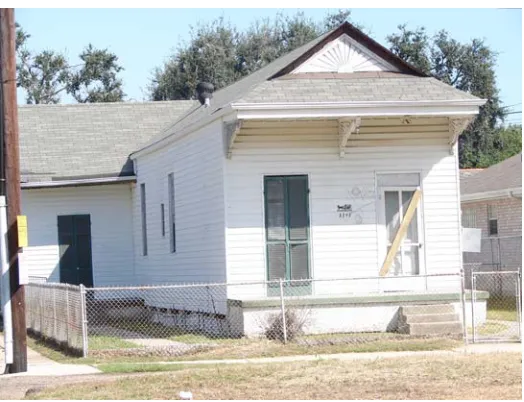
The Sugar Hill neighborhood, located in the Gentilly section of New Orleans, Louisiana
was developed in the 1940s and grew as a result of the construction of Dillard University for
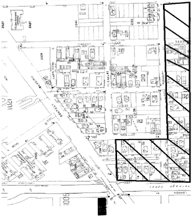
African Americans seen in Figure 1.
Figure 1. Evaluated subsection of Sugar Hill Source: Sanborn Map Image
The neighborhood boundaries for Sugar Hill are Elysian Fields Avenue, London Avenue,
Florida Avenue and Gentilly Boulevard. Figure one is a map of the subsection evaluated. It
shows the number of residences present in 1939-1951. As a result of Dillard University’s
construction in 1935, this section of the city began to serve as a hub for many middle to upper
income African Americans, such as doctors, lawyers, and teachers some who have played a role
in the history of our city and the nation. Prior to the construction of Dillard University, this area
mainly consisted of dairy farms and was considered to be located on the outskirts of the City of
New Orleans. Today, this neighborhood retains a significant amount of its original features,
however it was severely impacted by the construction of Interstate 610 in 1967. The interstate
construction removed eleven square blocks of the neighborhood forever altering the landscape of
this community. Sugar Hill was again crippled 38 years later by the Hurricane Katrina. Even
though a significant number of structures in this neighborhood are at Base Flood elevation, the
nearby London Avenue Canal levee break caused the neighborhood to be inundated with about
5-6 feet.
Prior to the Hurricane Katrina, several residents of this neighborhood were exploring the
possibility of this neighborhood becoming a National Register District. This was based on what
they believed to be architectural and cultural significance. Current conditions indicate that most
of the residents have returned. However, with little guidance about how to retain architecturally
significant elements, residents have made hasty and insensitive repairs unknowingly altering and
removing significant elements from their structures. This thesis will use the criteria from the
National Register to determine if this neighborhood has sufficient surviving architectural and/or
New Orleans has a multitude of African American culturally significant sites, however
many have been demolished or remain undiscovered. Currently, there are only thirteen African
American culturally significant sites in New Orleans listed on the National Register of Historic
Places. The Alexander Pierre Tureaud adult home is the only residential listing on the National
Register for African American cultural significance as of August 2006. Tureaud was a civil
rights lawyer for New Orleans’ local chapter of the NAACP who filed numerous cases in an
effort to end segregation. One of New Orleans most prominent Figures, Louis Armstrong has a
place on the National Register, however it is in New York. His presence is ever so vivid in New
Orleans, however only local landmarks pay homage to this noteworthy Figure. His childhood
home was demolished in an effort to make way for the City Hall and Duncan Plaza. A plaque in
his honor has been placed on the site, however the structure is not present. Landmarks in his
honor exist have been established but lack concrete details. For instance, Armstrong’s affiliation
with Milne Boy’s Home is speculation because formal research has not been accumulated
sufficiently to warrant it a landmark. Another significant site, the former buildings located in the
100 block of South Rampart Street that housed the studios of the New Orleans first professional
woman photographer and other African American small businesses, have also been demolished.
African American history has interwoven threads of disparities, however significant individuals
did prosper through adversity and accomplished many African American firsts. As a result of
these significant accomplishments these individuals deserve their legacies to be physically
acknowledged through historic preservation. Sugar Hill has a number of residences that are
directly affiliated with a number of African American significant Figures. The 1940s
development of this neighborhood is not only significant to New Orleans history, but also to the
Limitations
The major limitation of this thesis is that one person, the author, conducted the
nomination and recommendations. In order to formally nominate this neighborhood for historic
consideration, it would require support of the neighborhood association, the local Historic
District Landmarks Commission, the City Council representative and the Mayor. Once that is
achieved, this research would have to be verified and supported by the State Historic
Preservation Office.
The criteria for establishing a national historic district began with the
implementation of the National Historic Preservation Act of 1966. A nomination form is
available from the National Park Service. The form has set criteria to evaluate if the assemblage
of properties can warrant historic district qualifications. “To nominate a district it must be
significant, as well as being an identifiable entity. It must be important for historical,
architectural, archeological, engineering, or cultural values.
Criteria A, B, C, D
There are four criteria for evaluation, Criteria A, B, C, and D. Criterion A allows a
property to be eligible if it is associated with significant historic events. Criterion B allows a
property to be eligible if it is associated with a person of historical significance. Criterion C
allows a property to be eligible if it embodies the distinctive characteristics of a type, period, or
method of construction, represents the work of a master, or possesses high artistic values,
represents a significant and distinguishable entity whose components may lack individual
distinction. Criterion D allows a property to be eligible to be placed on the National Register if it
for structures that are not regarded as eligible, such as cemeteries, birthplaces, graves of historic
Figures, properties owned by religious institutions or used for religious purposes, structures that
were moved from an original site, properties commemorative in nature, and properties that have
achieved significance within the past 50 years (National Park Service [NPS, 1999]). Such
properties can only qualify if they are integral parts of districts that do meet the previously
mentioned criteria. Historic districts that are significant will usually meet the last portion of
Criterion C plus Criterion A, Criterion B, other portions of Criterion C, or Criterion D (National
Park Service [NPS, 1999]).”
This paper will focus on Criteria B in that there are properties in this neighborhood
associated with people of historical significance. In addition, Criteria C is used because the
Methodology
This is a qualitative analysis, which consists of archival research about the development
of Gentilly Sugar Hill. The research began with finding historic maps at the Historic New
Orleans Collection that charted the development of the area. This included the use of historic
aerial maps that show the development of this area prior to habitation up to the development of
pie-shaped plantation lots that projected from Bayou Sauvage. Also Sanborn maps, which were
used for insurance assessments, were used to chart the development of the lots within the
neighborhood after it was subdivided. The Sanborn maps assisted in identifying the oldest
structures in the neighborhood and served as a sketch map for current contributing and
non-contributing structures. With the information gathered from the Sanborn maps, a chain of title
search was conducted at the New Orleans Notarial Archives to determine the exact age of the
structures and who the initial owners were. The names of the owners were cross-referenced with
the New Orleans Public Library’s historic Polk directories, a city directory that gave the
occupation, name, and home address of each resident. The New Orleans Public Library,
Sewerage and Water board connection dates were also used to document the development of the
neighborhood, such as infrastructure development. The Dillard University archives were used
to cross reference names of important individuals and to correlate the neighborhood’s
development with the populating of the adjacent neighborhood. Personal interviews with
neighborhood residents were used to attempt to fill the informational gaps. Five personal
interviews spanning from October 2005 to January 2006 were used to document information
about who lived in the neighborhood during its span of significance and how Interstate 610 and
Chapter One discussed the limited amount of African American historic districts in the
United States. The purpose and scope of this thesis is to see if Sugar Hill warrants a place on the
National Register. It also discussed my methods of research. Chapter Two will discuss early
preservation efforts, how areas become historic districts, how many National Register districts
are in New Orleans, the National Preservation Act of 1966 and the National Register of Historic
Chapter 2
Review of Literature: History of Preservation
Early Preservation Efforts
Preservation efforts began in the United States in the early 1800s. One of the first efforts
to preserve the nation’s heritage came when the Philadelphia State House later known as
Independence Hall was saved from demolition. Other efforts were established by the Mount
Vernon Ladies Association, ma group that formed to save Mount Vernon, the former residence
of the nation’s first president, George Washington (“Ladies of Mount Vernon Association,”
n.d.). The first federal preservation funding occurred in 1872 when Yellowstone, the first
National Park, was established in Wyoming (“Early History of the Preservation Movement,”
n.d.). Federal funding of preservation was initiated in 1889, when Congress appropriated $2,000
to preserve Casa Grande ruins in Arizona. The Antiquities Act of 1906 was the country’s first
national legislation adopted for preservation (“Early History of the Preservation Movement,”
n.d.). It designated national monuments on the federal level and established penalties for
destroying these preserved places. In 1916, the National Park Service (NPS) was established in
the United States Department of Interior as an administrative agency for the federally designated
areas. During this time larger areas such as historic battlefields and colonial urban developments
were being recognized as National Park sites. In 1926 Williamsburg, Virginia was the first
physical restoration of an assemblage of structures a preservation project funded by John D.
Rockefeller. In 1929 Henry Ford purchased Greenfield Village, a 90 acre plot of land which was
established the “Old and Historic District,” the country’s first historic district. The local planners
and citizens of this city developed a historic zoning ordinance and established a Board of
Architectural Review. The Historic Act of 1935 was adopted by Congress in an effort to employ
out of work architects and photographers to create the Historic American Building Survey
(HABS) and the Historic American Engineering Survey (HAER), to document noteworthy
historic structures throughout the United States (“Early History of the Preservation Movement,”
n.d.). Later in 1936 with enabling legislation, the Vieux Carre’ in New Orleans was established
as the nation’s second historic district. In 1949, chartered by Congress, the National Trust for
Historic Preservation (NTHP) was established. The NTHP linked private efforts with those of the
National Park Service (NPS, 2000).
How Areas Become Historic Districts
Federally designated historic districts are placed on the National Register, but offer little
legal protection from individual alterations to architectural elements. In order to become a
National Register District, a nomination form has to be completed and submitted to the State
Historic Preservation Office for review. In New Orleans local historic districts were established
by state enabling legislation from 1976. An ordinance was created and empowered the New
Orleans Historic District/Landmarks Commission to regulate, preserve, and protect historic
districts and landmarks within the City of New Orleans; and providing for the powers, duties,
authority, and standards of said Commission (HDL1976). The process begins by appointing a
study committee to investigate the significance of the selected neighborhood. Local academic
institutions and the Historic District Landmark Commission aid the committee. The committee
regional expression, and establishing neighborhood boundaries. The City Council is responsible
for designating local historic districts. For each historic district created by the City Council, not
less than one (1) member shall be appointed (whether by appointment or reappointment) who
shall be a resident or property owner within said historic district (HDLC 1976). Local historic
districts have the ability to place restrictions on the actual property owners.
National Register Districts in New Orleans
There are twenty-one National Register Historic District in New Orleans. The districts
are Algiers Point, Broadmoor, Bywater, Carrollton, Central City, Esplanade Ridge, Faubourg
Marigny, Garden District, Gentilly Terrace, Holy Cross, Irish Channel, Lower Central Business
District, Lower Garden District, Mid-City, New Marigny, Parkview, South Lakeview, Uptown,
Upper Central Business District, Dillard University and the Vieux Carre ( PRC 2007). At the
same time there are two National Register eligible districts in New Orleans, Pontchartrain Park
and Edgewood Park. Since Hurricane Katrina extensions of districts have been sought after by a
number of established National Register Districts. The extensions are regarded as National
Register eligible, which means as an eligible district is entitled to the same review process as if it
were a designated district.
The National Preservation Act of 1966
The National Historic Preservation Act of 1966 established a federal program that
recognized historically significant local and state properties. Its purpose, declared by Congress
on October 15, 1966, was to preserve the irreplaceable by creating historic preservation
project implementation (United States Department of Interior, 1966). The historic significance is
based on architectural, archeological, and cultural significance. This act also created the
Advisory Council on Historic Preservation (ACHP), an independent federal agency composed of
19 members in the Executive Branch of the government. The National Historic Preservation Act
of 1966 established national historic districts, as designated assemblages of structures that
contribute to the historic context of an area (United States Department of Interior, 1966).
Properties or districts can be nominated by any person or local government to be included on the
National Register. The Secretary of the Interior in consultation with the national historic and
archaeological associations establishes and/or revises the criteria for properties to be included on
the National Register. Nominations can be accepted or rejected and/or appealed by any person
or local government. Owners of potential property are given the opportunity to “concur or
object” to the nomination of the property (United States Department of Interior, 1966). The
Secretary of the Interior is required under Section 110 of this act to require that all Federal
agencies “preserve and use” historic properties as well as establish a “uniform process standard”
of documenting historic properties. At least once every four years, there is a “review of threats”
carried out by the ACHP and the State Historic Preservation Officer (SHPO) to review if
properties eligible for inclusion on the National Register are being affected by federal projects
(United States Department of Interior, 1966). The State Historic Preservation Office (SHPO) is
responsible for administering a state’s historic preservation program and conducting statewide
surveys. It also maintains inventories of historic properties, identifies and nominates properties,
organizes the “comprehensive” statewide historic preservation plan, manages a state program of
federal assistance within the state and advises federal, state, and local governments on how to
serves as a facilitator to local governments in the development of historic preservation programs.
It works with the Secretary of Interior, the ACHP and other entities to ensure that properties of
historic significance are taken into consideration when a federal agency is involved. It also
serves as a consultant with federal agencies when an undertaking triggers the Section 106
process. “The head of any federal agency that has jurisdiction over a proposed federal project or
assisted in an undertaking in the United States, prior to approval of funds must take into account
the effect of the undertaking on any district, site, building, structure, or object that is included in
or eligible for inclusion on the National Register (United Department of Interior, 1966).”
The National Register of Historic Places
The National Register of Historic Places is a listing of the nation’s historic places that are
historically, architecturally and/or culturally significant (National Park Service [NPS, 1999]).
The National Register was created by the National Historic Preservation Act. It is governed by
the NPS under the Secretary of the Interior. The National Register includes all the historic areas
in the National Park System, National Landmarks, and properties nominated by the SHPOs,
federal agencies or Tribal Preservation Officers that have been approved by the National Park
Service (National Park Service [NPS, 1999]). The National Register of Historic Places “help
preserve significant historic places by recognizing the irreplaceable heritage (National Park
Service [NPS, 1999]).” Anyone can nominate a property by submitting a National Register of
Historic Places form to the appropriate SHPO. Listing a property on the National Register
allows owners under certain circumstances to obtain grants or tax credits through federal historic
preservation funding and triggers the Section 106 process if a proposed project has any federal
Tribal Historic Preservation Officer. There are four types of nominations. The first is a state
nomination, in which any person or SHPO staff member can prepare a nomination form. The
second type of nomination is approved or disapproved by the SHPO then a final decision is made
by the NPS. Upon approval by the NPS, the nominated structure or structures are officially
entered into the National Register. Federal nominations for properties under federal ownership
are given to the NPS through a FPO appointed by the agency heads. These nominations are
revisable by the corresponding SHPO comment and then the nominations are forwarded to the
NPS for final approval. The third type is a Tribal nomination. The Tribal Historic Preservation
Officer submits nomination to the NPS. The Secretary of Interior must have an approved tribal
preservation plan in place. The final type of nomination is by private persons or a local
government. The NPS can accept a nomination from persons or a local government if the
property or properties are located in a state without a SHPO. The National Register nominated
properties must meet a set of criteria in order to be eligible. Nominated districts, sites, buildings,
structures, and objects that possess integrity of location, design, setting, materials, workmanship,
feeling and association and that embody one or more of the four criteria are evaluated for
significance in American history, archeology, architecture, engineering and culture (National
Park Service [NPS, 1999]). The United States federal government designates historic districts
through the Department of the Interior under the NPS.
Early preservation efforts created a foundation for the conservation of the built
environment. With federal involvement, NHPA recognized entire neighborhoods as historic
districts and also created the National Register, a listing of the nation’s historic places. Districts
on the National Register of Historic Places are not subjected to as many regulations as a local
This chapter discussed how early preservation laid the foundation of methods to retain
the built environment. In addition it discussed how the National Preservation Act of 1966
created the concept of historic district and the Advisory Council for Historic Preservation.
Chapter 3 will discuss the early developments of the Sugar Hill neighborhood, the opening of
Chapter 3
The Making of a Neighborhood
Early Neighborhood Development
Topographically, Sugar Hill is located on the southern side of what is known as the
Gentilly Ridge seen in Figure 2.
Figure 2. Topographic Cross Section of New Orleans
Source: http://en.wikipedia.org/wiki/Image:New_Orleans_Levee_System.svg#filelinks
The Sugar Hill neighborhood is higher in elevation because of the natural levees formed
from Bayou Sauvage, a filled waterway that once followed the route of Gentilly Boulevard and
led to Bayou St. John. After Bayou Sauvage was filled, emerging drainage and levee system
technology, such as man made levee creation and the invention of the screw pump made more
the Darcantel and Judge Martin Plantation. The Judge Martin Plantation had two pie-shaped lots
that occupied both sides of what was Bayou Savage. (See Figure 3)
Figure 3. Judge Martin and Darcantel Plantations Source: Mitchell 1993
This plantation is named for its owner Francois Xavier Martin, who was Attorney
General for New Orleans in 1809. In 1836 he became a Supreme Court judge and because of his
French heritage was responsible for translating court documents from French to English. He is
known as the “Father of Jurisprudence,” because of his efforts of harmonizing French, English
Figure 4. Judge Martin
Source: Center for Louisiana Studies http//cls.louisiana.edu
The Darcantel plantation was sold and subdivided in 1831 (New Orleans Public Library
Louisiana Division 2002). The Ponchartrain Rail Road Company bought Darcantel Plantation
in 1831 for $18,000. The company was chartered in 1830 and began operation on April 23,
1831. Its tracks extended along Elysian Fields Avenue. The rail lines ran the entire length of
Elysian Fields Avenue to Milneburg, a popular recreation spot for New Orleanians located on the
shores of Lake Pontchartrain. Much of Milneburg burned after the railroad stopped operating in
1932. The company also kept a steady income by transferring mail to Lake Ponchartrain, so that
ships could carry the parcels to Mobile, Alabama (New Orleans Public Library Louisiana
Division 2002). The Ponchartrain Railroad Company had a train station stop where Gentilly
time that the railroad operated seen in Figure 5.
Figure 5. Evidence of tourist cottages Source: Sanborn Map Image 1929-39
The availability of automobiles increased the amount of major arterial paving projects
from the Works Progress Administration (WPA) in the 1940s. Gentilly Boulevard was a major
Figure 6. The Paving of Gentilly (WPA) Dillard University in the Background Source: http://nutrias.org/photos/wpa/wpa33.htm
In 1917 the Automobile Blue Book created a map showing routes throughout New
Orleans that were paved. As a result, these routes were more favorable to automobile travel as
Figure 7. Favorable paved routes in New Orleans
Still located on the outskirts of New Orleans, this newly subdivided area was occupied by
dairy farms seen in Figures 8 and 9.
Figure 8. Dairy Cow on Neutral Ground 1939
Source: http://nutrias.org/photos/wpa/images/33/338103.jpg
In a 46-year period (1845-1891) this area transformed from wooded swampland to a
formalized street grid pattern that remains virtually the same today. Sugar Hill's
boundaries are seen in Figure 10.
Figure 10. Detailed Street map of the Entire Sugar Hill neighborhood Source: Google Maps 2007
Along with the street patterning came city infrastructure, which allowed drainage
previously filled waterway (Bayou Savage), in which run-off drained into the Marigny Canal
(currently known as the Florida Avenue Canal), which at the time connected to Bayou St. John.
From there the gravity driven run off was deposited into Lake Pontchartrain. By 1835 formal
measures began to regulate drainage. The New Orleans Drainage Company was given a 20-year
charter to drain the city's swamps between the Mississippi riverbank and Lake Pontchartrain
(Rogers 2006). By 1850 there was an expedited need for formal drainage technology because of
yellow fever outbreaks within the city's core. However, the city's topography caused a problem
for gravity-powered drainage because the ridge and the natural shore levee acted as barriers and
as a result caused the water to remain in lower lying areas. In 1857 the area was surveryed by
Louis H. Pilie (Roger 2006). New technology development that used open drainage canals along
with four steam powered paddle wheel stations designed to lift collected runoff to brick lined
canals. These were called drainage machines. In 1858 the Louisiana Legislature divided the city
into four drainage districts (Rodgers 2006). They were called New Orleans First and Second,
Jefferson City and Lafayette Draining Districts. Each district was allotted $350,000 from a local
taxation allowed it to have a steam powered drainage pump. One of these machines was located
at the intersection of London Avenue, Pleasure Street, and Gentilly Boulevard. The prime
function of this drainage machine at that time was to move the water north of Gentilly Ridge
(Rogers 2006).
Sugar Hill’s west boundary began with the construction of the London Avenue Canal, as
a result of Pilies’ drainage system. It removed Havana Street from this neighborhood. The
building of the London Avenue Canal began in the 1860s, but it was only partially completed. It
was extended to Lake Pontchartrain in about 1878. In 1893, a hurricane created a huge storm
Pontchartrain (Rodgers 2006). As the city’s population increased, a formalized drainage plan
had to be implemented. As a result, the Sewerage and Water Board was created. By 1929
Baldwin Wood, a mechanical engineer, who worked for SW&B had mastered new drainage
techniques. In Figure 11 is a diagram of how the water displacement process works.
He has a prominent place in New Orleans history by creating the famous screw pump
which was able to move massive amounts of water out of the city. The screw pump had a
propeller that used electricity to spin causing a siphoning action to occur.
As a result it lifted water from the city’s drainage canals, which then flowed into Lake
Pontchartrain. Drainage continues to be a major issue that plagues New Orleans to this day.
Figure 11: Figure Baldwin Wood Screw Pump
Source: http://www.loyno.edu/history/journal/1995-6/haydel.htm#41
By 1908 the New Orleans Terminal Company Railroad had constructed rails along
was required to meet the fire code in the neighborhood was located on Frenchmen Road. There
were two industries, which began to operate in the neighborhood that imported and exported
materials via the new rail line. They were the Standard Cotton Oil Company and The Stand
Guard and Chemical Manufacturing Company. Where these two companies operated still exists
as an industrialized section of Sugar Hill, bounded by Florida Avenue, Elysian Field Avenue and
Abundance Street. Industrial uses spread along the Florida Avenue portion of the neighborhood.
By 1917 the introduction of the automobile began to create major arterials throughout the city.
Road conditions were improved and Sugar Hill was snuggled between two major arterial streets,
Gentilly Boulevard and Elysian Fields Avenue that provided fluid traffic flow. Frenchmen
Road, a newly paved road at the time, served as a feeder type that ran parallel to Elysian Fields
Avenue. It connected to Gentilly Road (now Gentilly Boulevard) which provided direct access
to the New Orleans Fair Grounds and at the same time connected with other arterials for better
navigation of the city. In 1929, according to the Sanborn Insurance maps, a fairly cohesive
Figure 12. Early neighborhood development Source: 1929-39 Sanborn map image
Residences were clustered in various parts of the neighborhood, primarily along streets
that connected to Gentilly Road near St. John Berchmans Manor, one of the oldest existing
structures in the neighborhood as well as the city which has landmark possibilities because of its
connection with local and national African-American history. It was erected in 1891 as an
orphanage and industrial home for colored girls with a donation from Thomy Lafon. This
philanthropist and businessman donated $12,000 to the Sisters of the Holy Family, the first order
Figure 13. St. John Berchman in 1938
Source: New Orleans Public Library http://nutrias.org/photos/wpa/images/15/15281.jpg
Figure 15. Sugar Hill’s population growth from 1939-51 Source: Sanborn Map image copyright 2007
While other areas struggled during the Depression years 1929 to 1934, the population of
Sugar Hill grew. Entire square blocks throughout the neighborhood began to fill in with houses
as seen in Figure 14. The massive population surge established Sugar Hill as an informal model
of African American suburban home ownership prior to Pontchartrain Park. At this time the area
was still considered to be on the outskirts of the city. The most popular type of housing
constructed were double and single shotguns in the Craftsman style of architecture, which
Dillard University
The 1930s mark a significant point in Sugar Hill’s history. Plans had begun to merge
New Orleans University and Straight College into one entity. The site for the new construction
was located on Gentilly Road next to Mt. Olivet Cemetery. Dillard’s construction was
completed in 1935, a year before the Pontchartrain Railroad removed its tracks. Affluent and
influential African-Americans began populating this neighborhood, which was named after
James Harvey Dillard. Dillard, a Virginia native (1907-1931), served as president of the Jeanes
Foundation for Negro Schools. This foundation was started by Anna T. Jeanes, a Pennsylvania
Quaker, who wanted to contribute to the improvement of Negro education in the South
(Middleton 1981). In Figure 16 is an early photograph of the campus, which is currently on the
National Register as a district, because of architectural and cultural significance. Ten structures
on Dillard University’s campus are considered contributing elements to the architectural
significance of the district. At the same time it is culturally significant because of its place in
Figure 16. Dillard University 1936
Source: Dillard University Archives and Special Collections. http://books.dillard.edu/Archives/index.htm
The origin of the merger leading to the founding of Dillard University began in 1928
when James O’Brien, president of Straight College, contacted Edgar Stern for an emergency
$500 grant. Stern, a New Orleans native, philanthropist and businessman, decided after meeting
with Edwin R. Embree, president of the Rosenwald Fund, to create protocols to assist African
Americans in New Orleans (Richardson 329). Stern had close ties to the Rosenwald fund
because he was married to Edith Rosenwald, the daughter of Julius Rosenwald who owned Sears
Roebuck. At that informal meeting the two men discussed the merger of the two colleges to
create one entity. The American Missionary Association, an agency of the Congregational
church had founded Straight University in 1869. By1877 Straight University was located on
and Tonti Street in 1878. The University was named after Seymour Straight, a New Orleans
philanthropist that opposed slavery.
New Orleans University was established in 1866 by the Thomson Biblical Institute,
named after Bishop Edward Thomson to train freedman the ministry of the cloth (Bernard and
Clytus 2007). In 1869, the institute became the biblical department at Union Normal School,
which began as a venture driven by the Methodist Episcopal Church’s Freedman Aid Society.
After the Civil War, the Freedman Aid Society funneled governmental funds and volunteers to
the southern states directed toward educational opportunities for African Americans. The Union
Normal School formed in 1866 and trained black teachers. In 1873 Union New Orleans School
became New Orleans University. The new University’s charter required medical students that it
trained to be affiliated with Charity Hospital of New Orleans to get proper experience in a
functioning hospital. The program lacked funds for development until it received a donation
from John D. Flint of Fall River, Massachusetts. It served as the only medical school where
African Americans could train and practice in the south. The Phyllis Wheatley Sanitarium, later
renamed Sara Goodridge Nurse Training School, was formed in 1896 and began to provide
health care alternatives for African Americans who could afford it. By 1901, this group had lost
funding and sought help from New Orleans University. The University secured a grant from
Caroline Mudge who renamed the unit after her mother Sara Goodridge. By 1910, Flint Medical
College had lost funding because of the physical condition of the school facilities. It was forced
to close as a result of the lack of funding for the needed renovations. The Flint Medical College
ultimately closed in 1911. In 1916, the Sarah Goodridge Nurse Training School merged with the
African American medical centers to form Flint Goodridge Hospital. After Dillard University‘s
University. It was the first unit of Dillard to be constructed, however it was located in Uptown
New Orleans rather than in Gentilly where the main campus is located. The hospital remained in
existence until 1983. It closed at this time because it funding as a result of desegregation
(Bernard and Clytus 2007).
Camp Leroy Johnson
The next significant growth factor in Sugar Hill was sparked by the establishment of
Camp Leroy Johnson, which opened in 1942. It was located on the lakefront adjacent to the sea
wall. Figure 17 shows an aerial view of the military base.
Figure 17. Camp Leroy Johnson prior to the construction of University of New Orleans Source: New Orleans Public Library--Images of the Month http://www.nutrias.org/~nopl/
The facility was located between the Shushan Airport built in 1934, currently known as the New
UNO’s east campus is located. Camp Leroy Johnson was a U.S. Naval Air Station previously
known as the New Orleans Army Air Base. In 1947, the name was changed to Camp Leroy
Johnson in honor of Leroy Johnson, a soldier from Oakdale, Louisiana during WWII. Sgt.
Johnson was deployed to the Philippines on December 15, 1944 during the Battle of Leyte, a
battle that ended the stronghold that Japan had on the Philippines. As the American troops
joined forces with the overthrown Philippine guerillas to take back this small island, Sgt.
Johnson unselfishly threw himself on top of two hand grenades tossed back on the American
troops. Sgt. Johnson died from his wounds, but was awarded the Medal of Honor for his heroic
efforts to save his battalion. The base named after him was also used with the New Orleans
airports as training facilities during WWII. The military personal located at Camp Leroy Johnson
lived in barracks that were built in the area from modern day Leon C. Simon Boulevard to
Florida Avenue. As a result of the 22 year existence of Camp Leroy Johnson, the Sugar Hill
neighborhood streetscape has various types of military housing units that are now more than 50
Figure 18. Army Barracks located on the municipal Square 1965 Source: Sanborn map image. Square 1965 is a typical layout of barracks.
Decline of Sugar Hill
Sugar Hill’s decline came with the rise of suburbia and automobile dependency along
with construction of inner city interstate highways that carved out massive parts of the
neighborhood. Sugar Hill suffered from the construction of the Interstate 610 loop. When it was
initially announced in 1956, the proposed interstate caused a debate among residents. However
plans were not changed. Eminent domain was used as the tool to remove an entire section of
Sugar Hill. According to the tax records and Sanborn Maps prior to the demolition, this area in
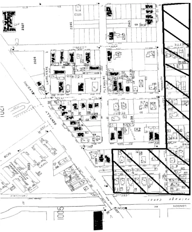
Figure 19 Area removed for construction of Interstate 610 Source:. Sanborn Map Image copyright 2007
Figure 20 Area removed for construction of Interstate 610 Source:. Sanborn Map Image copyright 2007
Residences that were on the London Avenue side of New Orleans Street were demolished
in order to provide an off ramp and a total of eight blocks of residences were also demolished
between Humanity Street and Benefit Street from Elysian Fields Avenue to London Avenue.
This bisected the landscape of the neighborhood. According to the oral histories conducted as a
part of this research from Ms. Ethel in October 2006, after the interstate was constructed people
began to move out of the neighborhood. More housing options were available at that time. The
neighborhood lost much of its cohesiveness since a major interstate highway now bisected it.
In 1965, Hurricane Betsy caused significant wind damage to structures in the
neighborhood. 42 years later Hurricane Katrina devastated the area with as much as seven feet of
floodwater caused by the break in the London Avenue Canal floodwall. Structures built on or
close to the Gentilly Ridge sustained only minor or no flood damage. However, structures a few
blocks from the ridge sustained significant damage from floodwater that could not be pumped
out immediately. Currently almost all the properties are occupied or in the last stages of
rehabilitation and only one has been sold to the state through the Road Home Program.
This chapter discussed the pre-neighborhood development of this area in New Orleans.
In addition it also discussed the how Dillard University and Camp Leroy Johnson affected the
neighborhoods demographics. Chapter four will discuss the physical boundaries of Sugar Hill.
Chapter 4
Physical boundaries
Figure 21. Outlined Boundaries of Target Area Source:. Cno-gis.cityofno.com copyright 2007
As part of the research for this project, I surveyed a subsection of the Sugar Hill
neighborhood that included a total of 88 properties. The boundaries of this selected area are
Gentilly Boulevard, St. Anthony Avenue, Humanity Street, New Orleans Street and London
Avenue as seen in Figure 20. Practically all of the structures are residences except for St. John
properties located on these squares. The main site located at 2601 Gentilly Boulevard is the
older structure. The newer facility faces St. Anthony Boulevard.
From city documents, I learned that huge Oak or Chincapin trees inhabited this area prior
to development. The area also had Pecan, Sweet Gum and Myrtle trees seen in Figure 21. This
area was coined the Highland Oak Grove because of the Oak tree that stretched from Gentilly
Figure 22. Map outlines the types of trees indigenous to this area
Source: New Orleans, Louisiana 1849 "Diagram showing the inundated District Sauvé's Crevasse” May 3rd 1849. Fac-similie of an old drawing." From Report on the Social Statistics of Cities, Compiled by George E. Waring, Jr., United States. Census Office, Part II,
1886http://www.lib.utexas.edu/maps/historic_us_cities.html#N
These immensely beautiful trees formed a natural tree canopy that can still be seen on
Figure 23. Pauger Street Southern view Source: Author, 2006
Remnants of these trees can also be seen on Live Oak Street, which was developed in the
1930s according to city records, which documented that water or sewage lines to the building
located at 3439 Live Oak Place were initially connected in 1939 (see Figures 23, 24, and 25).
Figure 24. Live Oak Place
Figure 25.Current image of Live Oak Place Source: Google Earth Image 2007
This particular area of the neighborhood in its glory spanned from Gentilly Boulevard at
its north to Humanity Street at its south. Mature oak trees line the neutral ground and were used
in the landscaping of the residential buildings. I conducted this research from October 2005 to
July 2007. Prior to the neighborhood development, Gentilly Boulevard served as part of a
Native American trail that was also used by the British soldiers followed the course of Bayou
Figure 26. Shows the Trial along Bayou Savage at the top of the Map
Native Americans along with the French settled in this area because of its higher
elevation. The area then became part of Judge Martin’s Plantation and consisted of about seven
tracts of land, which was subdivided in March of 1845, one year before Francois Xavier Martin’s
death. Thomas Barrette, according to city documents, was allotted a parcel of land that began at
Gentilly Boulevard to the north and ended at New Marigny suburb to the south. Alphonse
Milton Berger, Julies Larrigne, Henry Hopkins, Robert Gembler and James Hopkins, who also
owned Hopkins Plantation east of the Darcantel Plantation, purchased the seven tracts of
subdivided land. The area purchased by Thomas Barrette contained the future site of St. John
Table 1
Architectural Styles in the Target Study Area by Municipal Squares
Style Type 2140 2139 2138 2327 2326 2286 2287 2289 Total %
WWI Cottage 5 1 2 2 8 2 20 23
Arts and craft Single 0 2 3 2 1 8
Double 0 3 4 3 10
Raised double
1 1 2 23
Louisiana Vernacular
Single 3 1 1 5 6
Eastlake Single 1 1 1
Mission Institutional 1 1 1
International Institutional 1 1 1
Other Single 1 2 1 1
Double 2
Duplex 1 2 8 9
No Style Cottage 2 2
Severely Altered 1 1 1 2 3 3
Ranch Single 9 5 4 3
2 story 1 24 27
Outbuildings Single 1 1 1
Minimal Traditional Single 1 1 2 2
Total 17 16 14 2 2 18 15 4 88 99
To evaluate the properties for architectural significance, I used the New Orleans Historic
District Landmarks Commission’s (HDLC) Evaluation Guide as a tool. I used the HDLC’s
evaluation guide because it provided a simple checklist to evaluate exterior architectural
elements on the structures. Even though this thesis is about seeing if Sugar Hill warrants a place
on the National Register, the HDLC’s evaluation guide was used because it provided effective
method of analyzing each property. Out of the 88 surveyed properties I chose 9 to thoroughly
research. HDLC’s exterior Evaluation Guide consists of six different rating categories according
to architectural significance. The rating system uses a color coding to categorize the buildings.
The lowest rating color is gray for unrated buildings. A gold rated building is one that
contributes to the scene. A red rated building is of importance but has been altered. A green
rated building is of architectural or historical significance. A blue rated building is of major
architectural importance. A purple rated building is the highest level of architectural significance
and designates buildings of national importance. Only one among the properties surveyed is a
vacant lot.
Twenty-five out of the eighty-eight are unrated structures, which are Ranch style homes
that were built in the 1950s as infill development. Fifty-nine structures contribute to the scene
because of the remaining massing and setbacks. There are three green rated buildings.Of the nine
properties thoroughly researched three were found to be of architectural significance. At the
same time six properties were found to be culturally significant.
This chapter discussed the physical boundaries as well as the pre neighborhood
of house types and styles. The next chapter will discuss the architectural development of Sugar
Chapter 5
Architectural Development
Figure 27. Prior 20th Century development Source: Vogt 1985
While the predominantly residential nature of Sugar Hill spans a period of architectural
significance from 1890-1950, the greatest number of residences date prior to the 20th century
(see Figure 27). The original Judge Martin and Darcantel Plantations were subdivided beginning
in the mid 1800s. Judge Martin Plantation was subdivided into seven sections in 1845.
emerge in the early 1900s. For example Square 2139 was purchased in 1909 for $2,100 by Mrs.
Louis Gayarre D’Abadie, wife of Bernard D’Abadie. Lot sizes vary in each square throughout
the neighborhood. St. John Berchmans Manor is the oldest structure in the neighborhood. This
masonry building was constructed in 1925 and it originally served as an orphanage.
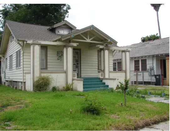
The most common house types in this neighborhood are the shotgun and single family
cottage. There are single, raised and double shotguns throughout the neighborhood. Figure 28 is
a sketch of the general exterior and interior of a double and single shotgun. The double shotgun
is a frequently occurring house type. There are rows of this particular house type in the Arts and
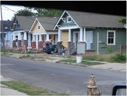
Crafts style. In Figure 29, streetscapes of double shotguns in the Arts and Crafts style are shown.
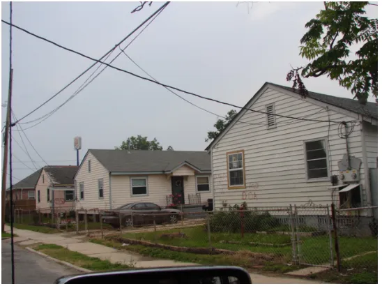
The other frequently occurring house type is the cottage type, commonly known as the
Figure 29. Streetscape of Double Shotguns Source: Author, Feb. 2006 Frenchmen Street
Figure 31. One of the neighborhood’s oldest structures Source: Author, March 2007 3430 Annette Street
Figure 32. Typical WWII cottage
Figure 33. Typical WWII cottage floor plan Source: Author, May 2007
There are also single shotguns in this neighborhood that predate the doubles seen in
Figures 30 and 31. This area developed as a true suburb of New Orleans. It did not have the
elements of a sustainable community. It lacked churches, schools, markets and recreational
facilities. The land use of the neighborhood was almost entirely residential with St. John
Berchmans Manor being the only exception.
The principal material used in a significant number of structures in the neighborhood is
wood weatherboards. At the same time other exterior materials are used such as stucco and brick
veneer. The dominant architectural style is Arts and Crafts. The scale of the structures varies
because of construction periods and housing types. The older structures with weatherboards,
particularly the Arts and Crafts bungalows, are painted more vivid colors than later
constructions. The older structures include bracketed, Eastlake, and Arts and Crafts shotguns,
scales. The setbacks are another indication of the property age. Older properties lack front
lawns and are in close proximity to the street. Many structures were heavily damaged from wind
and the floodwaters. Figure 34 illustrates the contributing properties in the study area. The
contributing properties have either retained a substantial amount of architecturally significant
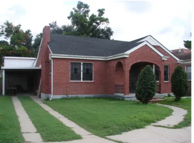
elements and/or are of cultural significance. The district is mainly comprised of World War II or
Cape Cod cottages. These types of structures make up 53% of the housing style in the
neighborhood. Other styles include Arts and Craft, Louisiana Vernacular, Eastlake, Mission
Ranch, International and other styles, which include historic structures with no specific style.
Most of the structures’ exterior materials are wood weatherboards. The main type of
construction method is stick frame and at the same time a significant number of the residences
have brick exteriors. A total of 27.2% of the properties are non-contributing to the architectural
significance.
This chapter discussed the various architectural styles and house types in the
neighborhood. The next chapter summarizes the properties selected for thorough research. Each
property is outlined with reasoning for significance, a full description of the property’s exterior,
the property’s ownership history, and/or the biographies of noteworthy figures affiliated with the
Figure 34. Contributing Properties
Chapter 6
Architectural Significance
This neighborhood meets Criterion C because it embodies the distinctive characteristics
of a type, period, or method of construction, or represents the work of a master, possesses high
artistic values, or represents a significant and distinguishable entity whose components may lack
individual distinction (NPS, 1992). Many of the architectural styles in this neighborhood are
present in other National Register and Local Historic Districts in New Orleans. For example,
Sugar Hill has a number of structures in the Arts and Crafts architectural style, a popular style of
the 1930s, are seen throughout New Orleans. Sugar Hill also has California bungalow style
houses very similar to the type seen in Gentilly Terrace, a local historic district and Edgewood
Park, a National Register eligible district. This neighborhood has a multitude of architectural
styles that reflect the period of construction. The earliest constructions are shotguns in the
Bracketed style as seen in Figure 35. Other styles include Arts and Crafts (see Figure 36 and
37), English Cottage style (See Figure 38), WWII Cape Cod Cottage style (See Figure 39) and
Figure 35. Bracketed shotgun 3345 St. Anthony Avenue Source: Author, October 2005
Figure 37. 3400 block of New Orleans Street. Later Arts and Crafts. St. Denis Street Source: Author, October 2006
Figure 39. WWII Cottage. 3301 Frenchmen St Source: Author, October 2006
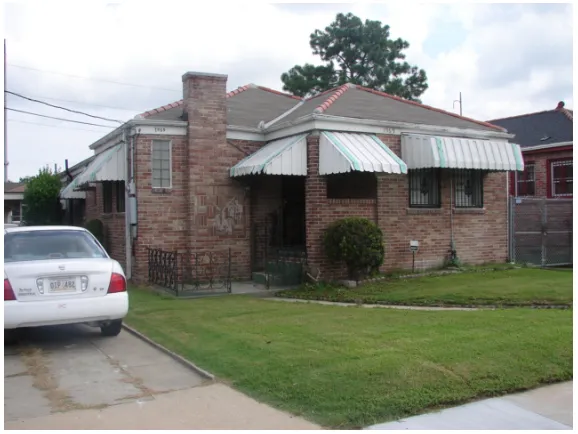
Surveyed Architectural Styles and Properties
1961 Humanity
Figure 41. Daste Home Source: Author, June 2007
Significance
The Daste home is located at 1961 Humanity Street. It is a contributing element to the
Sugar Hill neighborhood. This single family one story dwelling was constructed in April of
1946. This residence is an example of the most common type of residential architectural design
for its period. 53% of the structures within the surveyed area are of this WWII/Cape Cod cottage
style.
Description
The Daste Home is a single story 5 bay frame constructed residence with brick veneer on
the exterior. Its plan and architectural details are typical of the residential WWII/ Cape Cod
cottage style residence. The structure is situated on a raised slab and has a cross-gabled roof
facing south. The roofing material used is architectural asphalt. Attic venting is located between
the roof gables on the west wall. The façade of the structure has a porch with rounded brick
arches that terminate at brick columns into a simplified Doric capitol. The baseless column shaft
terminates at the porch’s concrete floor, which is also part of the raised slab foundation. On the
structure’s west wall there is a wood burning chimney. It has K-style gutters and 2 steps
constructed of brick that lead to the front entrance from the meandering concrete path that begins
at the public right-of-way. The entrance to the residence is a multi-lite paneled wood door with
an additional ornamented cast-iron security door. The windows remain in frame, but have been
changed from the original wood to a 2 over 2 aluminum type. The window’s exterior also has
ornamented cast-iron security bars. The structure has an attached carport, which is supported by
metal corrugated polls. The carport’s flat roof projects from an attached utility room. The
one exterior wood door facing south. A double strip concrete driveway terminates at the carport,
which is not part of the raised slab.
History
According to city records this property was purchased on April 30, 1946 by Alden Daste,
who worked as a bricklayer in 1945 according to the Polk Directories. The property was then
acquired by Floyd L. Reeves in 1950 and sold again in 1955 to Phillip Caprite who immediately
sold it to Rita Olivier for $15,000. By 1969 the property was part of Ann Ebbs Hulbert and
Russell Hulbert succession. The daughters of the deceased, Gayle and Leona Hulbert inherited
the property. In 1989, the property was sold at a tax sale to Kevin P. Nelson for $25,000, who is