University of Windsor University of Windsor
Scholarship at UWindsor
Scholarship at UWindsor
Electronic Theses and Dissertations Theses, Dissertations, and Major Papers
1-1-2006
Shore platform processes in eastern Canada.
Shore platform processes in eastern Canada.
Neil James Porter
University of Windsor
Follow this and additional works at: https://scholar.uwindsor.ca/etd
Recommended Citation Recommended Citation
Porter, Neil James, "Shore platform processes in eastern Canada." (2006). Electronic Theses and Dissertations. 7108.
https://scholar.uwindsor.ca/etd/7108
SHORE PLATFORM PROCESSES IN EASTERN CANADA
By
Neil James Porter
A Thesis
Submitted to the Faculty o f Graduate Studies and Research through Earth Sciences
in Partial Fulfillment o f the Requirements for the Degree o f Master o f Science at the
University o f Windsor
Windsor, Ontario, Canada
2006
Library and Archives Canada
Bibliotheque et Archives Canada
Published Heritage Branch
395 W ellington Street Ottawa ON K1A 0N4 Canada
Your file Votre reference ISBN: 978-0-494-35969-3 Our file Notre reference ISBN: 978-0-494-35969-3 Direction du
Patrimoine de I'edition
395, rue W ellington Ottawa ON K1A 0N4 Canada
NOTICE:
The author has granted a non
exclusive license allowing Library
and Archives Canada to reproduce,
publish, archive, preserve, conserve,
communicate to the public by
telecommunication or on the Internet,
loan, distribute and sell theses
worldwide, for commercial or non
commercial purposes, in microform,
paper, electronic and/or any other
formats.
AVIS:
L'auteur a accorde une licence non exclusive
permettant a la Bibliotheque et Archives
Canada de reproduire, publier, archiver,
sauvegarder, conserver, transmettre au public
par telecommunication ou par I'lnternet, preter,
distribuer et vendre des theses partout dans
le monde, a des fins commerciales ou autres,
sur support microforme, papier, electronique
et/ou autres formats.
The author retains copyright
ownership and moral rights in
this thesis. Neither the thesis
nor substantial extracts from it
may be printed or otherwise
reproduced without the author's
permission.
L'auteur conserve la propriete du droit d'auteur
et des droits moraux qui protege cette these.
Ni la these ni des extraits substantiels de
celle-ci ne doivent etre imprimes ou autrement
reproduits sans son autorisation.
In compliance with the Canadian
Privacy Act some supporting
forms may have been removed
from this thesis.
While these forms may be included
in the document page count,
their removal does not represent
any loss of content from the
Conformement a la loi canadienne
sur la protection de la vie privee,
quelques formulaires secondaires
ont ete enleves de cette these.
ABSTRACT
This study examines the erosional processes operating on horizontal and sloping shore platforms
in eastern Canada. About 110 traversing micro-erosion meter (TMEM) stations were installed in
three areas. TMEM downwearing data in basalts, argillites, and sandstones by wetting and drying
and salt weathering have been supplemented with data obtained from tidal simulators in the
laboratory. Downwearing rates, measured over periods from 1 to 3 years, generally ranged
between 0 and several mm yr'1. Erosion rates generally increase towards the upper intertidal zone
in fresh water and artificial sea water. Rock surface expansion and contraction owing to water
uptake and loss were measured through tidal cycles in the field and in the laboratory. The data
suggest that downwearing by weathering and backwearing by waves are both important on shore
platforms, though there are temporal and spatial variations in their absolute and relative
significance.
CO-AUTHORSHIP STATEMENT
Included in this thesis are tw o m anuscripts form atted to thesis requirem ents:
1. The m anuscript entitled “ Shore Platform Processes In Eastern C anada” is in press
w ith the journal G eographie Physique et Quaternaire. The paper is co-authored
by Trenhaile, A.S., Porter, N .J. and K anyaya, J.I. and appears in chapter 2.
2. The m anuscript entitled “Short-term rock expansion and contraction in the
intertidal zone” was subm itted to the journal Earth Surface Processes a nd
Landform s. The paper is co-authored by Porter, N .J., and Trenhaile, A.S. This
m anuscript appears in chapter 3.
The study was directed by A.S. Trenhaile, who also contributed to the data interpretation
and drafting o f the m anuscripts. N .J. Porter and J.I. K anyaya w ere largely responsible for
data collection, and both contributed to the data analysis and interpretation. N .J. Porter
DEDICATION
ACKNOWLEDGEMENTS
I w ould like to express m y appreciation to all those people who have aided m e during the
course o f m y research. In particular, I w ould like to extend a special thank you to m y
advisor, Dr. A lan Trenhaile, for all the support he provided me during the past tw o years.
By far the m ost understanding and supportive advisor anyone could ask for. In addition,
special thanks go out to Dr. Eric M attson, Dr. John Kovacs and Dr. Jaim e LeC lair
(N ipissing U niversity) who were responsible for m y inspiration to succeed to the
M aster’s level.
I w ould also like to acknow ledge m y appreciation to Shanm ugam Johari Pannalal,
Jacob K anyaya, Juan Carlos O rdonez-Calderon, Steven Rozic and K aiguang Zhu for all
the technical advice and friendship; thanks guys, I ow e you one! Finally, I w ould like to
express m y sincerest thanks to Sharon H om e. Thanks for all the insider inform ation and
allow ing me to participate in your skulduggery activities. Y ou got m e in, and out o f
STATEMENT OF ORIGINALITY
“I certify that, this thesis, and the research to w hich it refers, are the product o f m y ow n
work, and that the ideas or quotations from the w ork o f other people, published or
otherw ise, are fully acknow ledged in accordance w ith the standard referencing practices
o f the discipline. I acknow ledge the helpful guidance and support o f m y supervisor, Dr.
TABLE OF CONTENTS
ABSTRACT iii
CO-AUTHORSHIP iv
DEDICATION v
ACKNOWLEDGEMENTS vi
STATEMENT OF ORIGINALITY vii
LIST OF TABLES x
LIST OF FIGURES xi
LIST OF APPENDICES xv
CHAPTER 1: Introduction, literature review and objectives
1.0 Introduction 1
2.0 The “wave vs. weathering” debate 2
3.0 Shore platform morphology 3
4.0 Wetting and drying weathering 5
5.0 The expansion and contraction of rock surfaces 6
6.0 The effect of salt 8
7.0 Purpose and objectives o f the research 9
8.0 Study areas 10
9.0 Methodology 13
9.1 Intertidal wetting and drying: salt and de-ionized water 13
9.2 Core and cube break-down 14
9.3 Expansion and contraction o f rock surfaces 15
9.4 Abrasion 16
10.0 S ignificance of the proj ect 17
References 18
CHAPTER 2: Shore platform processes in eastern Canada
1.0 Introduction 24
2.0 The study areas 24
3.0 Methodology 30
3.1 The laboratory 30
3.2 The field 31
4.0 Results 32
5.0 Discussion 38
5.1 A shore platform model 41
6.0 Conclusions 42
CHAPTER 3: Short-term rock expansion and contraction in the intertidal zone
1.0 Introduction 48
2.0 The study areas 49
3.0 Methods 52
4.0 Results 55
5.0 Discussion 67
5.1 Short- versus long-term changes in surface elevation 68
5.2 Do short-term changes in surface elevation cause 69
long-term surface downwearing ?
6.0 Conclusions 72
References 74
CHAPTER 4: Project update
1.0 Introduction 76
2.0 Salt and fresh water weathering 76
2.1 Breakdown rates in fresh water 77
2.2 Breakdown rates in salt water 80
2.3 Fresh and salt water comparisons 80
3.0 Statistical analysis: Analysis of variance 84
3.1 Post hoc comparisons: The Scheffe test 85
3.2 Statistical comparisons between fresh and salt water 85
References 90
APPENDICES
Appendix A: Declaration of co-author contributions 91
Appendix B-K: In CD format, laboratory and field data CD
LIST OF TABLES
CHAPTER 2:
Table 2.1
CHAPTER 3:
Table 3.1
Table 3.2
Table 3.3
CHAPTER 4:
Table 4.1
Table 4.2
Table 4.3
Table 4.4
Table 4.5
Table 4.6
Table 4.7
Canadian Tidal definitions (Canadian Hydrographic Service).
Some characteristics of the rocks from the platforms o f eastern Canada.
Descriptive statistics for annual, TMEM-measured changes in surface elevation at individual points at 46 active (records of more than 2 years) TMEM stations in eastern Canada1.
Downwearing rates in the field and in artificial sea water (mm yr"1).
Mean rates of downwearing (mm yr'1) using artificial sea water and de-ionized water over a 38 month period. (210 cores, 2300 cycles, 38 months). Hudec rock set.
Descriptive statistics for downwearing rates between artificial sea water and de-ionized water for 28 months.
ANOVA Statistical Analysis for Tidal Simulators 1 through 4.
ANOVA Statistical Analysis Comparison between 28 months Artificial Sea Water and De-ionized water.
Scheffe post hoc comparisons between cells, simulators 1 through 4.
Scheffe post hoc comparisons between cells, salt and fresh water.
LIST OF FIGURES
CHAPTER 1:
Figure 1.1
Figure 1.2
Figure 1.3
Figure 1.4
Figure 1.5
Figure 1.6
Figure 1.7
Figure 1.8
CHAPTER 2:
Figure 2.1
Figure 2.2
Figure 2.3
Theories for horizontal platform development (from Trenhaile 1987).
a) sloping liassic limestone and shale platform in the Vale of Glamorgan, south Wales, UK; and b) horizontal aeolianite platform with a low tide cliff near Lonsdale, southern Victoria, Australia.
The relationship between mean regional shore platform gradients and spring tidal range (Trenhaile, 2003).
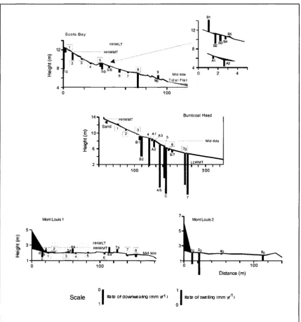
Study areas in eastern Canada
(a) Horizontal metamorphic argillite platform at Mont Louis, Quebec; (b) Sloping red sandstone at Bumtcoat Head in the Minas Basin; and (c) Sloping basaltic platform at Scots Bay in the Bay of Fundy.
Simulators used to mimic “real time” tidal cycles: (a) fresh water tidal simulator; and (b) salt water tidal simulator.
Measuring expansion and contraction of rock surfaces using the MEM: (a) Laboratory experiments o f three samples representing rocks from Eastern Canada; and (b) MEM assembly on the Burntcoat Head platform.
Abrasion assembly: (a) Oscillating top carriage, comprised of 5 separate compartments; and (b) MEM station mounted on granite rock sample.
The study areas at Mont Louis in Quebec and at Scots Bay and Burntcoat Head in Nova Scotia.
The three shore platforms.
Figure 2.4
Figure 2.5
Figure 2.6
Figure 2.7
Figure 2.8
Figure 2.9
CHAPTER 3:
Figure 3.1
Figure 3.2
Figure 3.3
Figure 3.4
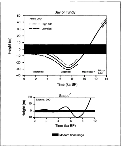
Changes in relative sea level on the south shore o f the St 29
Lawrence Estuary (Dionne, 2001) and in the Bay of Fundy (Amos, 2004).
A tidal simulator. Four simulators were used to measure rates of 30
downwearing generated by wetting and drying and salt weathering.
Downwearing rates measured over 17 months in de-ionized and 33
artificial sea water. Negative values, caused by increased water retention, and possibly associated with surface swelling, were omitted from the analysis. The numbers listed beneath each column represent the percentage o f each rock type sample, at each simulated tidal level, that experienced downwearing.
Relationships between rock strength, TMEM station elevation and 37
rates of downwearing in the three study areas.
a) Mean rates of laboratory downwearing by weathering in 40
artificial sea water at the high, mid- and low tidal levels (numbered 1, 2 and 3, respectively), b) Platform downwearing measured in the field with a TMEM. The shaded, horizontal bars represent the mean rates of downwearing, by all processes, that would have been required to reduce the seaward edge of the platforms in the study areas from the high to the low tidal level (LLWLT)(Table I) over the last 4000 years.
A generalized process model for sloping, macrotidal and 42
horizontal mesotidal shore platforms in eastern Canada. Rates of backwearing relative to downwearing will vary from place to place according to such factors as wave regime, tidal range, climate and geology.
The three study areas at Mont Louis, Quebec, and at Scots Bay 49
and Bumtcoat Head, Nova Scotia.
The three study platforms: a) Mont Louis is in argillite, b) Scots 50
Bay is in basalt, and c) Bumtcoat Head is in sandstone.
Platform profdes and location and number of the TMEM stations 52
used to measure short-term changes in surface elevation.
Argillite surface changes in the laboratory. The two boxed 57
Figure 3.5
Figure 3.6
Figure 3.7
Figure 3.8
Figure 3.9
Figure 3.10
Figure 3.11
Figure 3.12
CHAPTER 4:
Figure 4.1
Basalt surface changes in the laboratory. 58
Changes in surface elevation in the field. 59
The relationship between rock contraction (C) and tidal elevation 60
(Tl ) in the laboratory and the field. TL = 1 ,2 and 3 at the low, mid- and high tidal levels, respectively. Correlations (r values) are significant at the p = 0.05 level.
The relationship between rock contraction during tidal drying in 61
the laboratory (C) (using artificial sea water) and mean annual platform downwearing rate (Dw) in the three study areas. Correlations are significant at the p = 0.05 level.
Rock contraction and rock hardness (Schmidt Rock Test Hammer 62
rebound values) in the field.
Rock contraction (C) and air temperature and humidity (Rh) in the 63
laboratory and in the field. The sandstone correlation is significant at the p = 0.05 level.
Examples of duplicate measurements at the same point on the rock 65
surface under the same tidal conditions. The two boxed numbers, separated by a slash, show the mean temperature and relative humidity, respectively. The upper box is for the solid line and the lower box for the dashed line. Where there is only one line visible, the two runs were identical. Argillite laboratory data are only for slab 2.
Comparison between runs made at the same points at TMEM 66
stations in artificial sea water and in de-ionized water. The two boxed numbers, separated by a slash, show the mean temperature and relative humidity, respectively. The upper box is for salt water and the lower box for de-ionized water. Where there is only one line visible, the two runs were identical.
Downwearing rates measured over 34 months in de-ionized (simulators 1 78
& 2), 28 months and 14 months (simulator 3 & 4) in artificial sea water.
N egative values, caused by increased w ater retention, and possibly
Figure 4.2
Figure 4.3
Comparative downwearing rates between artificial sea and de-ionized 81
water, measured over 28 months Negative values, caused by increased water retention, and possibly associated with surface swelling, were omitted from the analysis. The numbers listed beneath each column represent the percentage of each rock type sample that experienced downwearing.
Breakdown characteristics of sandstone, argillite and basalt in artificial 83
LIST OF APPENDICES
APPENDIX A Declaration of co-author contributions. 91
APPENDIX B Monthly rock core weights for distilled water, tidal simulator 1 CD
(Excel format).
APPENDIX C Monthly rock core weights for distilled water, tidal simulator 2 CD
(Excel format).
APPENDIX D Monthly rock core weights for artificial sea water, tidal simulator CD
3 (Excel format).
APPENDIX E Monthly rock core weights for artificial sea water, tidal simulator CD
4 (Excel format).
APPENDIX F Laboratory expansion and contraction o f rock slabs, in fresh CD
water.
APPENDIX G Laboratory expansion and contraction of rock slabs, in salt water. CD
APPENDIX H Mean daily room temperature and relative humidity CD
(Excel format).
APPENDIX I Salinity, pH and specific gravity measurements for tidal CD
simulators 1 through 4 (Excel format).
APPENDIX J Statistical analysis: analysis of variance (ANOVA) and Scheffe CD
tests (Excel format).
C H A P T E R 1
Introduction, literature review and objectives
1.0 Introduction
Shore platforms are gently sloping to subhorizontal rock surfaces extending seawards, in
some cases for hundreds of metres, from the cliff foot. They are conspicuous elements of rocky
coasts in environments ranging from the poles to the tropics. Most shore platforms are essentially
intertidal and although they are produced by the retreat of coastal sea cliffs, the processes
responsible for cliff erosion and platform lowering may be quite different in type and/or intensity
from one platform to the next.
Earlier research regarding shore platforms was mainly descriptive (Trenhaile, 1987), and
because of the absence of almost any process measurements, arguments over the formative
processes, which began in the late 19th century, have been largely based on ambiguous field
evidence. As a result, genetic terminology, such as “wave cut platforms” (Bradley, 1958;
Edwards, 1958; King, 1963; Sorensen, 1968; Bradley and Griggs, 1976; Sparks, 1986);
“benches” (Zenkovich, 1967); “abrasion platforms” (Johnson, 1919); and “storm wave platform”
(Edwards, 1941) were common in the literature. Unless the responsible processes have been
identified, these terms should not be used because of their genetic connotation, which implies that
specific processes are responsible for platform formation. Much of the research on shore
platforms has, until the last few decades, been conducted by Australasian researchers, and their
depictions and interpretations have had a strong influence on the literature for nearly a century.
Weathering is generally thought to play an important role in the development of sub-horizontal
shore platforms in Australasia and in other swell- to low-wave energy environments (Wentworth,
1938, 1939; Hills, 1949, 1971; Gill, 1967, 1972; Bird, 1968; Davies, 1972; Stephenson and Kirk,
2000). Nevertheless, some workers have argued that waves are the main erosive mechanism on
these platforms (Bartrum, 1924, 1935, 1938; Johnson, 1933; Jutson, 193la,b, 1939; Edwards
1941, 1951). Waves have generally been assumed to be the dominant erosive agent on the sloping
platforms around the coasts of the stormy North Atlantic (Johnson, 1919; Everard et al. 1964; So,
2.0 The “wave versus weathering” debate
The mode of development of shore platforms has been disputed for over a century; the debate
is focused on the premise that platform formation is the result o f either wave erosion or sub-aerial
processes. Dana (1849) first proposed that platforms are cut by waves from coastal cliffs at a
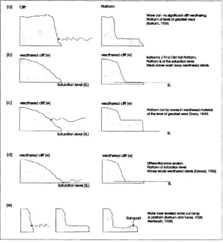
level o f maximum wear. Bartrum (1916) attributed the development o f “Old Hat” platforms in
sheltered environments, not to wave erosion at the level o f greatest wear, but to weathering of
cliffs down to an intertidal level at which the rocks are permanently saturated with sea water; the
role of the weak waves being simply to wash away the fine, weathered debris. Bartrum also
believed that horizontal “storm wave” platforms developed through wave erosion in more
exposed environments (Bartrum 1935, 1938). Many o f the earlier theories of platform
development have been focused around, and modified from, Dana’s and Bartrum’s models (Fig.
1. 1).
(a)
Wj/b cut • no dg rfte an t d ff w e a th e r^ . Ptatformat level of greatest wear (Bartrum, 1924)
(b) weathered d ff (w)
Saturation level (SI)
weathered cliff (w)
Bartrumr* {1916) Otd Hat Platform. Platform b a t th e sciurotton level Weak w w > wash aw ay woa thered debris.
(c) weathered d ff (w)
Saturation level (SI)
weathered d ff (w)
Platform cut by waves in weathered m ateria a t Ihe level of n e a te s t wear (D ana 1849)
(d) weathered d ff (w)
Saturation level (SI)
weathered d ff (w)
DWerantk* wave erosion. Platform a t saturation level
Waves erode wea there d debris (Edward, 1958)
(e)
Water layer leveled wave cut romp R am p art cxp*dcm7(BartnxnandTurnec 1928;
1 Wentworth 1938)
Although these theories formed the basis of early thinking, the weathering vs. wave erosion
debate is misleading because the two types of platform, even if such pure forms actually exist,
would represent only the two extremes o f a spectrum o f platform types in which both waves and
weathering assume variable roles according to the morphogenic environment (wave climate,
tides, etc) and the type o f rock (Trenhaile, 1987).
Contemporary theories have emphasized that shore platforms are the result o f both marine
and sub-aerial processes. Waves may be the dominant process in some areas, or at some stage in
the development o f a platform, providing the energy to pluck material from cliffs and platforms
(wave quarrying) and to move loose abrasives over the platform surface. However, weathering,
which includes wetting and drying, salt weathering, frost action and chemical weathering, often
plays an important role in wave-dominated environments, weakening the rocks and making them
more susceptible to wave erosion. In other areas, or at other times, weathering may be dominant,
and the role of waves and currents may be primarily to entrain and carry away the loose material.
3.0 Shore platform morphology
Shore platforms are usually characterized by one of two distinct morphologies: (a)
sloping platforms which have been called ramps, have gradients between 1° and 5°, and extend
from the cliff - platform junction (cliff foot) to below the low tidal level, without any marked
break in slope (other than those that are obviously attributable to structural or lithological
factors); and (b) horizontal platforms generally terminate abruptly in a low tide cliff or ramp (Fig.
1.2).
Although a few workers made some brief speculative comments on the possible effect of
tidal range on platform morphology (Edwards, 1941; King, 1959; Gill, 1967; Wright, 1967;
Davies, 1972), this factor was largely overlooked as a primary explanation for regional
differences in platform morphology (Trenhaile, 1978). Trenhaile (1972, 1974, 1978, 1987, 1997,
2002, 2003) investigated the role o f tidal range using data from south Wales (UK), southern
Japan, eastern Canada, NE and SE England and NW Spain. He found a moderately strong
positive relationship between shore platform gradient and tidal range (Fig. 1.3), which suggests
that tidal range, rather than climate and wave conditions, is the main reason for the occurrence of
horizontal platforms in the low tidal range environments o f Australia and New Zealand, and
sloping platforms in the high tidal range environments o f the North Atlantic (Trenhaile, 1999). In
eastern Canada, there are horizontal platforms in Gaspe, Quebec, where the tidal range is between
2.25 and 3.5 metres (Trenhaile, 1987), and sloping platforms in the Bay o f Fundy, where the tidal
range is between 12 to 16 metres (Trenhaile, 2004). Trenhaile (1999) also demonstrated that
platform width is independent of tidal range, but increases with wave intensity and decreases with
rock resistance. Within areas that have an essentially common tidal range, there is a tendency for
platform gradient to also increase with the strength of the rock (Trenhaile, 1972, 1978; Kirk,
1977; Sunamura, 1992).
6 - + Bay of Fundy, Canada
# Glamorgan, Wales
■ SE & NE England
+
5 - Gaspe Quebec
▼ W. Newfoundland +
♦ NW S pain +
4 - +
s
o
c • • +
*5 to
O 3 ~ • •m +
, © • • +
• E
2 -
■
•♦ I
1
1- ■
■
■ w /MS. ■
U i
c 5
i
10 15
Spring Tidal Range (m)
4.0 Wetting and drying weathering
Exposed rock surfaces are subjected to repeated cycles of wetting and drying in many
natural environments. Alternate wetting and drying can cause rocks to weather though the
absorption and adsorption o f water. Absorbed water essentially flows, drains or is sucked into the
rock, whereas adsorbed water can be attracted directly into the rock from humid air: this is
largely the result of electrostatic charges, involving the positive ends o f water molecules and the
negative edges o f clay particles in the rocks. Rock breakdown by wetting and drying depends on
its lithology and internal characteristics, including the presence of clay minerals, cleavage planes
and pore and capillary size (Bland and Rolls, 1998). Shales and other argillaceous rocks with
high clay content are more susceptible than most other rocks to expansion and contraction due to
alternate wetting and drying cycles. Other rock types that have no clay content, however, can also
be affected by the wetting and drying process (Nishioka and Harada, 1958; Nepper-Christensen,
1965; Hudec and Sitar, 1975; Felix, 1983; Hames et al., 1987).
Although many processes contribute to the lowering of platform surfaces, it is generally
assumed that alternate wetting and drying plays an effective role (Stephenson and Kirk, 2000;
Trenhaile and Kanyaya, 2004). Many o f the earlier Australasian investigations suggested that
platforms are produced through weathering down to an intertidal level o f permanent sea water
saturation (Bartrum, 1916; Edwards, 1958; Bird and Dent, 1966; Gill, 1967). This is contrary to
field and laboratory observations by Trenhaile and Mercan (1984), who demonstrated that there
is no permanent saturation level within the intertidal zone.
Numerous investigations have been conducted to determine the effectiveness of wetting
and drying on various types of rock. Goudie (1974) subjected sandstone and chalk to 58 and 43
alternate wetting and drying cycles, respectively, but he found no evident breakdown. Hall and
Hall (1996) exposed sandstone and dolerite to 140 wetting and drying cycles, and found that
wetting and drying can work independently of other physical processes. Many earlier laboratory
investigations found that alternate wetting and drying is not an effective weathering mechanism,
but this conclusion was derived primarily from experiments that had a fairly low number of
cycles. Although wetting and drying can operate as an independent process, limited data have
been obtained from the inter-tidal zone, which must offer almost optimum conditions for its
operation. Stephenson and Kirk (2000) proposed that a mudstone shore platform on the Kaikoura
Peninsula in southern New Zealand was produced entirely by weathering, especially by wetting
and drying, and they suggested that wetting and drying was most effective at elevations which
laboratory tidal experiments to closely imitate natural wetting and drying cycles in the inter-tidal
zone. Using artificial tidal simulators they subjected hundreds of sandstone, basalt, and argillite
samples from shore platforms in eastern Canada to more than 1000 tidal exposure and inundation
cycles over 18 months (these experiments are ongoing). Downwearing data were recorded for
different rock types at different elevations within the intertidal zone. Kanyaya and Trenhaile
(2005) found that the efficacy of wetting and drying varies throughout the intertidal zone, and is
dependent more upon the length o f the period of drying during low tide, than on the period of
absorption during high tide. In general, wetting and drying efficacy increases towards the upper
portions of the intertidal zone, where the rocks have more time to dry when they are exposed to
the air than at lower elevations.
5.0 The expansion and contraction of rock surfaces
It is generally accepted that expansion and contraction of rock surfaces under wetting and
drying conditions is due to the absorption and adsorption o f water. Although this process is not
fully understood, it must be closely related to the characteristics of the rock, such as its
permeability, porosity and mineral composition. Water can infiltrate or be adsorbed by rocks
through fine cracks or between mineral grains. Water is usually drawn into fine cracks due to its
bipolar nature. When cracks become wetted, the polar molecules are attracted to it, making a
layer of adsorbed water. This layer will create swelling pressures within the crack, and as
evaporation takes place, the sides may become drawn together by water molecules from adjacent
sides (Bland and Rolls, 1998). Repeated cycles o f wetting and drying eventually attack the
unstable mineral grains and in some circumstances, repeated expansion and contraction cycles
produce flaking of the rock surface.
Although many researchers have discussed the expansion and contraction of rock
surfaces, the development of the MEM (micro-erosion meter), which was introduced by High and
Hanna (1970), has made it possible to measure small variations in rock surface elevation in the
laboratory and in the field. A micro-erosion meter consists o f a simple engineer’s dial gauge,
affixed to a probe, which is mounted on a triangular frame. In use, this assembly is mounted upon
three bolts that have been sunk and permanently embedded in the rock (a MEM station): this
allows repeated measurements to be made at precisely the same place on a rock surface at regular
intervals. The MEM only permits three measurements to be made at each station but the
traversing MEM (TMEM) employs a series of ball-bearings that are fixed along each side of the
Stephenson, 1997; Stephenson et al., 2004).Micro-erosion meters allow precise measurement of
downwearing rates on rock surfaces. They have been applied to various problems, including the
measurement of downwearing rates on shore platforms (Robinson, 1977a,b; Kirk, 1977; Gill and
Lang, 1983; Mottershead, 1989; Stephenson and Kirk, 1996, 1998; Foote et al., 2001; Andrade et
al., 2002, Trenhaile and Kanyaya, 2004).
Downwearing rates have been measured on shore platforms with MEMs and TMEMs for
nearly thirty years, although most records are only 1 to 3 years in length. Many investigations
have reported downwearing rates on the surface o f shore platforms, but only a few researchers
have observed surface “swelling” (Kirk, 1977; Mottershead, 1989; Stephenson and Kirk, 1998,
2001). A few researchers regarded the “swelling” or rising phenomena to be due to operator or
instrument failure. Kirk (1977) first observed surface swelling on mudstone shore platforms on
the Kaikoura Peninsula in southern New Zealand. He attributed the rise o f 3 mm in elevation to a
combination o f algae growth and wetting of the mudstone. Further investigation o f the same
shore platforms showed that expansion and contraction varied on a seasonal basis (Stephenson
and Kirk, 1998), and it was proposed that salt crystal growth between the rock lattices and
expansion due to wetting and drying, particularly in response to higher summer temperatures,
was mainly responsible. Swelling of up to 9 mm has been observed in some extreme cases
(Stephenson and Kirk, 2001). Mottershead (1989) observed mean surface swelling of 0.04 mm on
greenschists in southern Devon, England. He concluded that the swelling was due to salt
weathering, but although salt weathering is likely to be effective in the higher temperatures of
summer, the data showed no clear seasonal pattern.
Trenhaile (2006) conducted a series of short-term expansion and contraction experiments
on sandstone, argillite and basalt slabs representing rock types from three shore platform study
areas in eastern Canada. These expansion and contraction experiments were subjected to tidal
conditions in de-ionized water and to a variety of humidity and temperature variations. He found
that the sandstones (from Bumtcoat Head, NS) did not expand or contract with the absorption or
adsorption of water nor, except in a very small number o f cases, did they expand or contract
owing to variations in temperature and humidity. He concluded that the porous nature of the
sandstone was sufficient to absorb water without generating any expansive pressures. The
argillite sample (from Mount Louis, Gaspe, PQ) was much more sensitive to tidally induced
expansion and contraction and temperature/humidity variations. Much o f the surface contracted
during the drying process when the rock was exposed, and it usually continued to contract until
wetting began again in the tidal cycle ended. Argillites under tidal conditions contracted between
30 to 100%. In some cases the argillites expanded under warm conditions. Trenhaile concluded
that the sensitivity o f the argillites to fluctuating environmental conditions is a result of their high
clay content, and their ability to absorp water when they are inundated by the tides and to adsorb
water from humid air when they are exposed by the tides. A basaltic rock sample (from Scots
Bay, NS) also contracted, typically between 0.01 to 0.02 mm, as it dried during low tidal periods.
Whereas the argillite continued to contract during the entire period o f exposure, the basalt had
usually attained its maximum contraction after 6 hours drying. There were also slight variations
in response to changes in temperature or humidity.
6.0 The effect of salt
The effect o f salt on rock breakdown has been a cause of concern for the past 2000 years
(Goudie, 1985). Extensive field and laboratory experiments, especially by French
geomorphologists in the 1950’s and 1960’s, illustrated the effects o f various salts on different
rock types (Birot, 1954; Pedro, 1957; Tricart, 1960). Salts are chemical compounds which are
produced between acids and bases, with water as a by-product (Bland and Rolls, 1998). Many
salts are water soluble, and for salts to be effective weathering agents they must be in the form of
a solution that can travel within the pores of the rock. The rate at which solutions can penetrate
rocks is primarily controlled by factors such as porosity (volume o f pore space), micro-porosity
(proportion o f micro-pores), water absorption capacity (amount of water absorbed in a specific
time) and saturation coefficient (amount of water absorbed in 24 hours, when sample is
immersed)(Trenhaile, 1987; Bland and Rolls, 1998).
The primary concern is with the physical effects o f salt solutions entering rock pores and
cracks. Salts contribute to rock breakdown in three ways (Cooke and Smalley, 1968):
1) by changes in the volume of a salt crystal, due to hydration;
2) by thermal expansion of salt crystals; and
3) by salt crystal growth due to the evaporation and concentration of solutions.
There have been numerous field and laboratory experiments on the efficacy o f salt
weathering on various rock types. Some of the earliest research began with laboratory
experiments which focused on the rate o f disintegration o f different sizes and shapes of samples
(Goudie, 1974; Robinson and Williams, 1982) and on the role of different salts on different types
Robinson, 1981, 2001). Nevertheless, few experiments have satisfactorily simulated natural
conditions (McGreevy and Whalley, 1984).
Visible signs of salt weathering are evident in coastal environments. Usually precipitated
by sea spray, salt crystals can form in between rock lattices or in pore spaces, causing the rock to
separate. Evidence of this phenomenon can be viewed as pitting or flaking on the surface of
coastal rocks, particularly during warmer seasons (Stephenson and Kirk, 2001). Although there is
a moderate body o f literature on salt weathering in coastal environments, few researchers have
considered its role in the development of shore platforms (Williams and Robinson, 1981).
Mottershead (1982) examined the role of salts on shore platforms consisting o f greenschist in
southwestern England. By calculating the pressure o f crystal growth within the pores, he
determined that salt concentrations of 1.5% above that of sea water was sufficient to cause rock
failure.
7.0 Purpose and objectives of the research
This research will contribute to an on-going investigation of the processes and evolution
o f sloping shore platforms in high tidal range environments and horizontal shore platforms in low
tidal range environments. My study is primarily concerned with the absolute and relative rates of
weathering and erosion resulting from intertidal wetting and drying and salt weathering. The
specific objectives of the study are:
1. to measure rates o f rock surface downwearing at various intertidal elevations owing
to the effect of wetting and drying and salt weathering; and
2. to compare these downwearing rates with measured rates o f platform downwearing
in the field.
The investigation will have three main components: (a) continuing and extending
Trenhaile and Kanyaya’s laboratory experiments to measure wetting and drying and salt
weathering downwearing rates in the laboratory; (b) measuring surface expansion and contraction
in the laboratory and in the field; and c) measuring platform downwearing rates in three study
8.0 Study areas
Eastern Canada probably has the greatest variety of tidal environments in the world, and
it may consequently be one of only a very few areas that have both regionally dominant
horizontal and sloping shore platforms. The three study sites represent a range o f tidal
environments and rock types: a meso-tidal horizontal platform at Mont Louis, Quebec; a macro-
tidal, sloping platform at Scots Bay, Nova Scotia; and a macro-tidal sloping platform at Bumtcoat
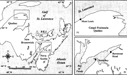
Head, Nova Scotia (Fig. 1.4).
6 2° v y
Gulf
(A )
St. Lawrence
M ont Louis
Quebec
Gaspe Peninsula Quebec P.E.I
New Brunswick
Burntcoat Head /N o v a
t I t Scotia Atlantic
Ocean
Bay
44° N-200 Km
100
Fundy
68° W 62° W
Figure 1.4. Study areas in eastern Canada
The Canadian Appalachian region includes the provinces of Nova Scotia, New
Brunswick, Newfoundland, Prince Edward Island, and the southern regions of Quebec. It
experienced numerous rifting and faulting events associated with the Paleozoic Appalachian
orogen, and the rocks in this region were subjected to extreme folding, faulting, metamorphism
and plutonism (Williams, 1995). The orogen began with the opening and closing o f the Paleozoic
Iapetus Ocean, resulting in sedimentary strata either being subducted or heavily folded during
continental collisions (Williams, 1995). Some of the oldest Paleozoic metamorphic rocks in
Canada are found along the southern shore of the St. Lawrence River.
There are horizontal shore platforms along approximately 600 km o f the southern shore
of the St. Lawrence River, between Quebec City and Cap-des-Rosiers (Trenhaile, 1978).
formation (Williams, 1995) and is characterized by extreme folding and tectonic
metamorphorism.
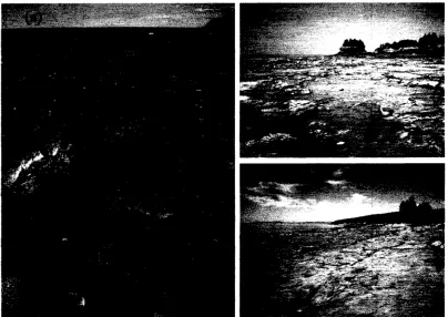
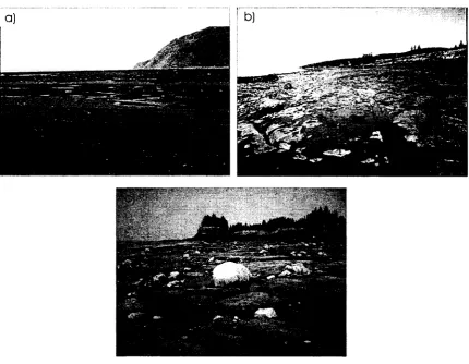
Figure 1.5. (a) Horizontal metamorphic argillite platform at Mont Louis, Quebec; (b) Sloping red sandstone at Bumtcoat Head in the Minas Basin; and (c) Sloping basaltic platform at Scots Bay in the Bay o f Fundy.
The shore platform at Mont Louis primarily consists o f dark grey argillites, with
graywackes, interbedded shales, and calcite intrusions (Enos, 1969). The shore platform is
elevated approximately 1 metre above the mid-tidal level and it ends abruptly seawards at a low
tide cliff o f unknown height. The platform is about 170 to 200 m wide and it is backed by a 3 to 4
meter high cliff, composed of the same Ethology as the platform. There is a coarse-grained beach
at the cliff foot. The platform surface is characterized by ridges o f dipping argillite and other
rocks with extensive pools between (Fig. 1.5).These pools persist during low tidal periods and
sustain small pockets o f flora and fauna. Eroded material accumulates in these pools where it
cannot be washed away by tides or waves.
The waves along the Gaspe coast usually approach from a westerly or northwesterly
direction, depending on seasonal variations. Nearly half o f the waves in this region (41%) are less
weather events. During the winter season, much of the coastline is protected by sea ice, which
acts as a barrier to the waves (Eid etal., 1991).
The red clastic sandstones at Bumtcoat Head in the Bay o f Fundy belong to the Triassic
Wolfville Formation, which has been interpreted as being alluvial fan deposits (Klein, 1962). The
highest tides in the world occur at Bumtcoat Head: the largest recorded tidal range is more than
16 m, but average tidal ranges are between 12 and 14 m (Trenhaile, 2004). A wide shore platform
runs along much of the southern shore of the Minas Basin. It is slightly concave upwards with an
overall gradient between 3° and 4° (Trenhaile and Kanyaya, 2004) (Fig. 1.5) and is between 375
and 450 m in width. There are undulating areas of more resistant sandstone on the platform in
places and stratified rock layers o f rounded pebbles deposited by fluvial processes. There are
large numbers of glacial erratics on the platform within the inter-tidal zone, many of large size;
these erratics probably fell from the cliff top as the cliff was undermined by erosion. Most o f the
surface of the platform has few marine organisms (mainly restricted to gastropods and seaweed in
the upper foreshore), although there are a variety of borers and burrowers in some large pools,
and an almost continuous cover of barnacles on the rock surface near the low tidal level. Waves
enter the Minas Basin from the southwest, west and northwest. The Minas Basin is quite
sheltered, however, and the majority of waves (78%) are less than 1 metre in height (Eid et al.,
1991).
The third study area is at Scots Bay in the Bay of Fundy, in the Triassic North Mountain
Basalts. Weaker basaltic surface features in this area are reinforced by resistant amydules,
primarily composed of calcite and minerals from the zeolite family (Colwell, 1980). The shore
platform is concave upwards, with a gradient of 7.5° in the upper part, 4.25° in the centre, and
3.5° in the lower segment (Trenhaile and Kanyaya, 2004) (Fig.1.5). The platform is
approximately 100 to 120 m in width. The upper portion of the platform, above the neap high
tidal level, is discoloured and extremely weathered. Lower segments o f the platform contain an
assortment of smaller, rounded boulders ranging in size from 5 cm to 30 cm in diameter. Much of
this lower segment is also covered by seaweed and small barnacles. The bottom of the exposed
platform surface passes into, and presumably continues below, a sandy tidal flat, as much as 500
9.0 Methodology
9.1 Intertidal wetting and drying: salt and de-ionized water
A series o f long-term experiments are being conducted to determine the effect of tidally
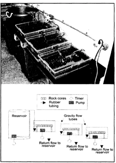
induced wetting and drying on shore platform development. Each of the four experimental
apparatuses used in the study, which function as tidal simulators, consists of a large reservoir and
three plastic basins (Fig. 1.6). Timers and pumps are used to transfer water from the reservoir into
each of the basins, and then to drain it back into the reservoir at prescribed times. Rock samples
were placed in the basins and elevated on a plastic screen, free from standing water once each
basin was drained. The samples were exposed to the experimental conditions under conditions
that simulated tidal cycles and did not accelerate the weathering processes. Water was allowed to
remain within the first o f the basins for eleven out of twelve hours (low tide), in the second basin
for six hours (mid-tide) and in the third basin, for one hour out of twelve hours (high tide). To
reduce the effects of accumulating salts from rock weathering, the pH o f the water was tested
weekly and, according to the degree o f alkalinity, de-ionized water was replaced at least every
month in the two simulators that use de-ionized water to study wetting and drying (Kanyaya and
Trenhaile, 2005). The other two simulators were used to study the effect o f salt weathering on
rock samples, using artificial sea water (35 parts per thousand). The salinity and specific gravity
o f the water was tested on a weekly basis, and the water was replaced each month.
Rock cores were extracted from a variety of rock types using a diamond-studded drill
bit, 1.9 cm in diameter, to produce a core 2 cm in length. Removal of the top and bottom o f each
core minimized the effects o f pre-experimental weathering. Sandstones from Bumtcoat Head in
the Bay o f Fundy, which were too friable to be cored, were cut into 2 cm cubes, then dried and
weighed using the same procedures as for the cylindrical cores. Each core (and cube) was
numbered and oven dried for 12 hours and then weighed. They were then placed in the basins and
submerged in the basins for one week to obtain their maximum wet weight. After numerous tidal
cycles, the rock samples were then again weighed to determine the amount of water absorbed
after 11 (low tide), 6 (mid tide), and 1 hour (high tide) inundation periods. Thereafter, once the
experiments had started, each sample was gently surface dried and weighed on a monthly basis.
Two rock sets were used in the experiments. The first set belonged to a series of rock, composed
of mainly carbonates, sandstones, igneous and metamorphic rock, collected from quarries in
southern Ontario by P.P Hudec at the University of Windsor. Most of the rock samples in the
Hudec collection were large enough to provide a minimum of seven cores per basin, although
only five could be cored from a few of the smaller samples. A total of 534 cores from the Hudec
collection were obtained, of which 324 cores were used for the fresh water tidal experiments and
210 for the salt water experiments. The second set of rock samples represented the three major
rock types in the shore platforms in the study areas: argillites from Mont Louis, Quebec; basalts
from Scots Bay, Nova Scotia; and sandstones from Bumtcoat Head, Nova Scotia. At the time of
writing, more than 675 basalt, sandstone and argillite cores and cubes have been subjected to
2050 wetting and drying cycles in de-ionized water over a 34 month period. In the salt water
experiments, 225 cores and cubes of basalt, sandstone and argillite have been subjected to nearly
1700 tidal cycles over a 28 month period. Another 150 basalt, 96 sandstone and 75 argillite cores
have been added to the salt water experiments, and they have experienced nearly 850 tidal cycles
over a 14 month period.
9.2 Core and cube break-down
To compare laboratory breakdown rates with platform downwearing in the field, as
measured with TMEMs, the loss in weight o f the cores and cubes was converted to equivalent
rates of surface weathering (Dr) (mm yr'1) using the following equation:
(Wr W2) 12
Dr = --- x x 10 (1)
p A T
where: Wi and W2 are the initial and final surface dried wet weights (g), p is the rock density
(g cm'3), A is the surface area o f either the cylinder or cube (cm2), and T is the number of months
Modes o f breakdown in de-ionised and salt water vary according to the type o f rock.
Granular disintegration occurs in the sandstones from Bumtcoat Head and the basalts from Scots
Bay, but splitting along the cleavage planes is dominant in the argillites o f Mont Louis. When
rock fragments separated from the core or cube (usually argillites but occasionally other types of
rock), the larger fragment was retained in the experiments and the smaller fragments, which were
considered to be eroded segments that would have been washed away by waves, were rejected.
9.3 Expansion and contraction of rock surfaces
A series o f short term experiments were conducted to measure the expansion and
contraction o f rock surfaces owing to the absorption and adsorption o f water. Micro-erosion
meter (MEM) stations were installed on slabs o f basalt, sandstone, and argillite (approximately
35 x 25 x 10 cm in size) from the three study areas in Eastern Canada (Fig. 1.7). Each rock slab
was placed within a plastic basin containing artificial sea water, and remained submerged for
either eleven, six or one hour intervals, out of a twelve hour tidal cycle (representing the low,
mid- and high tidal levels, respectively). Once the rocks were removed from the water, a TMEM
was placed on the stations and used to measure surface elevation as the slabs dried during the
remainder of the tidal cycle. To reduce potential measurement errors, the TMEM assembly
remained in place for the period of exposure. MEM readings were made during the initial
extraction from the solution and depending on the tidal level to be represented, every hour for
eleven hours (to represent high tide), every hour for six hours (to represent mid-tide) and one
hour (to represent low tide). Air temperature and humidity were also recorded on an hourly basis.
Micro-erosion meter stations that are used to measure rates of intertidal downwearing in
the field were also used, in the summer of 2005 and 2006, to measure surface expansion and
contraction. Transversing MEMs were placed on the stations as soon as they were exposed by the
falling tide, and measurements o f surface elevation were made for up to 8 hours as the rock dried
(Fig. 1.7). Refer to chapter three for detailed methods and results.
9.4 Abrasion
Weathering and wave erosion are the primary processes contributing to the lowering of
shore platforms, however, there are little quantitative data on their rates of erosion. A new
apparatus was designed and constructed to study the effects of abrasion in the swash and shallow
water zone o f coastal regions, where current direction alternates (Fig 1.8). The apparatus consists
of an oscillating top carriage, controlled by an electric motor and sensors that limit the amount of
tilt, and electronic switches that allow the oscillation velocity to be varied. The carriage is
composed o f durable, transparent plastic, divided into five equal compartments and covered by a
Figure 1.8. Abrasion assembly: (a) Oscillating top carriage, comprised of 5 separate compartments; and (b) MEM station mounted on granite rock sample.
universal, removable lid. To study the abrasion of surface rock the samples need to be fairly thin,
flat slabs, which requires either purchasing pre-cut rock, such as slate or granite, used primarily
in home renovations, or having the rock cut professionally to specific dimensions. Rock samples
are kept in place in the chambers by tight tolerances between the rock and a plastic composite;
the mating pieces (rock sample and plastic composite) can be easily disassembled for rock
sample replacement (Fig 1.8). Sample restraints are composed of a hard plastic composite,
machined precisely to allow the surface of the rock sample to sit flush. Both the sample and
added. Various types of abrasives will be used, ranging from cobbles to fine sand. Micro-erosion
meter stations will be installed in the experimental slabs and a TMEM will be used to measure
rates of platform downwearing. The abrasion experiments have been designed and the
equipment built during my tenure as a Masters graduate student, and I will start running them in
late 2006 or early 2007. However, it will take at least one year, and probably more, to obtain
meaningful results. These experiments will not, therefore, be included in my Masters graduate
research.
10.0 Significance of the project
There has been little research on the processes that are responsible for the development of
shore platforms on rocky coasts, and most theories are based on ambiguous field evidence. This
ongoing study, which began some time before I became a graduate student, represents the largest
and most encompassing quantitative study of platform processes that has ever been undertaken.
Large numbers of rock samples have already been subjected to hundreds o f tidal cycles using de
ionized water and artificial sea water. These experiments are not only much larger than previous
weathering studies in terms of the number of samples and the period of time over which they are
being conducted, but they are also one of the few experiments o f this type that have not
accelerated the responsible mechanisms. In the field, more than 110 transverse micro-erosion
meter (MEM) stations have been installed to measure downwearing rates on both sloping and
horizontal platforms. This is already the largest MEM/TMEM array ever installed, and
substantially more stations will be added over the next few years (to probably double the present
number). In conclusion, there has been no counterpart to my study, in term o f its scope and in the
employment of unique laboratory equipment that will allow experimental data to be compared
with, and to supplement, field data. This study will continue to provide essential data to further
our understanding o f the long-term development and evolution of rocky coasts in high and low
tidal range environments, their response to the predicted rise in sea level, and their contribution to
coastal sediment budgets.
The following two chapters consist of papers that have been submitted to international
journals. Chapter 2, entitled “Shore Platform Processes In Eastern Canada” is in press with the
journal Geographie Physique et Quaternaire. Chapter 3 is a paper entitled “Short-term rock
surface expansion and contraction in the intertidal zone”. This paper was submitted to the
journal Earth Surface Processes and Landforms on July 15, 2006. The final chapter, 4, includes
REFERENCES
Andrade, C., Marques, F., Freitas, M.C., Cardoso, R., and Madureira, P. 2002. Shore platform
downwearing and cliff retreat in the Portuguese west coast. In: Littoral 2000, The
Changing Coast. EUROCOAST/EUCC, Porto, Portugal, pp. 423-431.
Bartrum, J.A., 1916. High water rock platforms: a phase o f shoreline erosion. Transactions o f the
New Zealand Institute 48: 132-134.
Bartrum, J.A., 1924. The shore-platform of the west coast near Auckland: its storm wave origin.
Rept. Australian New Zealand Association. Advancement Science 16: 493-495.
Bartrum, J.A., 1935. Shore platforms. Rept. Australian New Zealand Association. Advancement
Science 22: 135-143.
Bartrum, J.A., 1938. Shore platforms. Journal o f Geomorphology. 1: 266-268.
Bartrum, J.A., Turner, F J. 1928. Pillow lavas, peridotites, and associated rocks from
northernmost New Zealand. Transactions o f the New Zealand Institute 59: 98-138.
Bird, E., 1968. Coasts. Massachusetts Institute of Technology Press, Cambridge, pp 246.
Bird, E., Dent, O.F., 1966. Shore platforms on the south shore o f New South Wales. Australian
Geographer. 10: 71-80.
Birot, P., 1954. Desagregation des roches cristallines sous Paction des sels. Comptes Rendus des
seances de I'Academie. des Sciences 238 (10): 1145-1146.
Bland, W., Rolls, D., 1998. Weathering: An Introduction to the Scientific Principles. Oxford
University Press, New York.
Bradley, W.C., 1958. Submarine abrasion and wave-cut platforms. Geological Society o f
American Bulletin 69: 967-974.
Bradley, W.C., Griggs, G.B., 1976. Form, genesis and deformation of central California wave-cut
platforms. Geological Society o f American Bulletin 87: 433-449.
Colwell, J.A., 1980. Zeolites in the North Mountain Basalt, Nova Scotia; Geological Association
of Canada-Mineralogical Association of Canada, Field Trip Guide Book, Trip 18, pp 16.
Cooke, R.U., Smalley, I.J., 1968. Salt weathering in deserts. Nature 220: 1226-1227.
Dana, J.D. 1849. Geology (Putman, New York), Rept. US Exploration Exped. 1838-1842 10: pp
109, 442.
Davies, J.L., 1972. Geographical Variations in Coastal Development. Oliver and Boyd,
Edinburgh.
Edwards, A.B., 1951. Wave action in shore platforms formation. Geological Magazine 88: 41-49.
Edwards, A.B., 1958. Wave cut platforms at Yampi Sound in the Baccaneer Archipelago.
Journal o f the Royal Society o f Western Australia 41: 17-21.
Eid, B., Dunlap, E., Henschel, M., Trask, J., 1991. Wind and Wave Climate Atlas. Vol. 1: East
Coast of Canada, Ottawa: Transport Canada.
Enos, P., 1969. Cloridome Formation, Middle Ordovician Flysch, Northern Gaspe Peninsula,
Quebec. Geological Society o f America Special Paper (Boulder, Colorado), 117, pp 66.
Everard, C.E., R.H. Lawrence, R.H. Witherick, L.W. Wright. 1964. Raised beaches and marine
geomorphology, p. 283-310. In K.F.G. Hosking, and G.J. Shrimpton, ed.,Present Views
on Some Aspects o f the Geology o f Cornwall and Devon. Royal Geological Society of
Cornwall, Truro, 330 p.
Felix, C. 1983. Essais de dilation lineaire par adsorption d ’eau sur des gres. Chronique des
Materiaux de Construction, Chantiers/Suisse. 15: 1-6.
Foote, Y., Plessis, E., Robinson, D., 2001. Rates and patterns of cliff erosion and downwearing of
chalk shore platforms: Comparisons between France and England. In Abstracts o f the
European Rock Coasts 2001 Conference. Brighton, England, pp 24-25.
Gill, E.D., 1967. the dynamics of the shore platform process and its relation to changes in sea
level. Proceedings o f the Royal Society o f Victoria 80: 183-192.
Gill, E.D., 1972. Ramparts on shore platforms. Pacific Geology. 4: 121-133.
Gill, E. D., Lang, J.G., 1983. Mircoerosion meter measurements of rock wear on the Otway Coast
of southeast Australia. Marine Geology 52: 141-156.
Goudie, A. S. 1974. Further experimental investigation of rock weathering by salt and other
mechanical processes. Zeitschrift fu r Geomorphologie Supplementband 21: 1-12.
Goudie, A.S, 1985. Salt weathering. Research paper 33. Oxford Press, London.
Goudie, A.S., Cooke, R.U., Evans, I.S., 1970. Experimental investigation of rock weathering by salts. Area 4: 42-8.
Greenough, J.D., 1995. Geology o f the Appalachian-Caledonian orogen in Canada and
Greenland', Chapter 6. (ed.) H. Williams; Geological Survey of Canada, Geology of
Canada, no 6, pp. 567-600. In: Geological Society o f America, The Geology of North America, F-l.
Hall, K., Hall, A., 1996. Weathering by wetting and drying: some experimental results. Earth
Surface Processes and Landforms 21: 365-376.
Hames, V., Lautridou, J., Ozer, A., Pissart, A., 1987. Variations dilatometriques de roches
High, C.J., Hanna, F. K., 1970. A method for the direct measurement of erosion on rock surfaces.
British Geomorphological Research Group Technical Bulletin. 5: 1-25.
Hills, E.S., 1949. Shore platforms. Geological Magazine 86: 137-152.
Hills, E.S., 1971. A study o f cliffy coastal profiles based on examples in Victoria,
Australia.Zeitschrift fu r Geomorphologie 15: 137-180.
Hudec, P.P., Siter, N., 1975. Effect o f water sorption on carbonate rock expansivity. Canadian.
Geotechnical Journal 12: 179-186.
Johnson, D.W., 1919. Shore processes and shoreline development, Wiley, New York.
Johnson, D.W., 1933. Role of analysis in scientific investigation. Geological Society o f American
Bulletin 44: 461-494.
Jutson, J.T. 1931a. Erosion and sedimentation in Port Phillip Bay, Victoria, and their bearing on
the theory of a recent relative uplift of the sea floor. Proceedings o f the Royal Society o f
Victoria 43: 130-153.
Jutson, J.T., 1931b. Shore platform near Sydney, New South Wales. Journal o f Geomorphology
2: 237-250.
Jutson, J.T., 1939. Shore platforms near Sydney, New South Wales. Journal o f Geomorphology
2: 237-250.
Kanyaya, J.I., Trenhaile, A.S. 2005. Tidal wetting and drying on shore platforms: an
experimental assessment. Geomorphology.70: 129-146.
King. C.A.M., 1959. Beaches and Coasts. Edward Arnold, London.
King, C.A.M., 1963. Some problems concerning marine plantation and the formation of erosion
surfaces. Transactions o f the Institute o f British Geographers 33: 29-43.
Kirk, R.M., 1977. Rates and forms o f erosion on intertidal platforms at Kaikoura Peninsula,
South Island, New Zealand. New Zealand Journal o f Geology and Geophysics 20: 571-
613.
Klein, G.D., 1962. Triassic sedimentation, Maritime Provinces, Canada. Geological Society o f
America Bulletin 73: 1127-1146.
Kwaad, F.J.P.M., 1970. Experiments on the disintegration of granite by salt action. University Amsterdam Fys. Geogr. En Boden Kundiq. Lab. Publ. 16: 67-80.
McGreevy, J.P., Whalley, W.B. 1984. Weathering: Progress Reports. Progress in Physical
Geography 8: 543-569.
Mottershead, D.N., 1982. Coastal spray weathering o f bedrock in the supratidal zone at East
Mottershead, D. N., 1989. Rates and patterns of bedrock denudation by coastal salt spray
weathering: a seven-year record. Earth Surfaces Processes andLandforms 14: 383-398.
Nepper-Christensen, P., 1965. Shrinkage and swelling of rocks due to moisture movements.
Meddelsomerfra Dansk Geologisk Forening. 15: 548-555.
Nishioka, S., Harada, T., 1958. Elongation of stones due to absorption of water. Review of the
12th meeting. Japan Cement Engineering Association, Tokyo, p. 66.
Pedro, G., 1957. Nouvelles Rechererches sur 1’ influence des sels dans la desagregetion des
roches. Comptes Rendus des seances de I'Academie. des Sciences 244: 2822-2824.
Robinson, D.A., Williams, R.B.G., 1982. Salt weathering o f rock specimens o f varying shape.
Area 14: 293-299.
Robinson, L.A., 1977a. Marine erosive processes at the cliff foot. Marine Geology 23: 257-271.
Robinson, L.A., 1977b. Erosive processes on the shore platform of Northeast Yorkshire shore
platform. Marine Geology 23: 339-361.
So, C.L. 1965. Coastal platforms o f the Isle of Thanet, Kent. Transactions o f the Institute o f
British Geographers 37: 147-156.
Sorensen, R.M., 1968. Recession of marine terraces—with special reference to the coastal area
north o f Santa Cruz, California, Proc. 11th Coastal Eng. Conf, American Society o f Civil
Engineers, pp 653-670.
Sparks, B.W., 1986. Geomorphology, 3rd edn, Longman, London.
Stephenson, W.J., 1997. Improving the traversing micro-erosion meter. Journal o f Coastal
Research. 13:236-241.
Stephenson, W.J., Kirk, R.M., 1996. Measuring erosion rates using the micro-erosion meter: 20 years o f data from shore platforms, Kaikoura Peninsula, South Island, New Zealand.
Marine Geology 131: 209-218.
Stephenson, W.J., Kirk, R. M., 1998. Rates and patterns o f erosion on inter-tidal shore platforms,
Kaikoura Peninsula, South Island, New Zealand. Earth Surface Processes and.
Landforms 23: 1071-1085.
Stephenson, W. J., Kirk, R. M., 2000. Development o f shore platforms on Kaikoura Peninsula,
South Island, New Zealand. II: the role of subaerial weathering. Geomorphology 41:5-
2 1.
Stephenson, W. J., Kirk, R. M., 2001. Surface swelling of coastal bedrock on inter-tidal shore
platforms, Kaikoura Peninsula, South Island, New Zealand. Geomorphology 41: 5-21.
Stephenson, W.J., Taylor, A.J., Hemmingsen, M.A., Tsujimoto, H., Kirk, R.M. 2004. Short-term