THE UTILIZATION OF RTK-GPS FOR REAL-TIME STRUCTURAL HEALTH DETECTION
Zuhaidah Nordin, Mohd Hafiz Yahya, Wan Aziz Wan Mohd Akib, PhD, and Zulkarnaini Mat Amin
Department of Geomatic Engineering Faculty of Geoinformation Science and Engineering
Universiti Teknologi Malaysia Skudai, Johor, Malaysia Tel: 075531955 / 075530937 Email: zuhaidah_nordin@yahoo.com
ABSTRACT: As safety precautions, the need for rapid assessment of the state of large engineering structure after extreme events such as earthquake, tsunami, typhoon or related wind effects is highly demanded. Compared to other often used practices such as acceleration integration method, laser distance gauge method and total station method, it is noted that GPS through static surveying technique is capable of providing 0.05 Hz of sampling frequency with location precision of 5~10 mm. Apparently, with the advent of Real-Time Kinematic (RTK-GPS) technique, deformations of various structures such as dams, wide span bridges, highways and high rise buildings can be monitored in real-time mode with 3D positioning accuracy of 10 mm ± 1 to 2 ppm (horizontally) and 15-20 mm ± 2 ppm (vertically). This paper therefore leads to a better understanding on RTK-GPS through simulation test made on a bridge in Universiti Teknologi Malaysia (UTM) campus. For the purpose of real-time structural health detection, well-calibrated GPS Trimble™ 4800 dual-frequency receivers and Pacific Crest™ radio modems were used in this study. By applying static survey mode to determine true coordinates in which will be used latter as “reference”, the test was then conducted in real-time using RTK-GPS mode. It is noted that GPS through the utilization of RTK-GPS is potentially capable of being deployed as an effective tool in structural health detection.
KEYWORDS: RTK-GPS, structural health detection
1. INTRODUCTION
paper tends to emphasize the concept of GPS measurements and its application in structural health detection. Particular investigations will be concentrated in the utilization of RTK-GPS through simulation test made on a bridge in Universiti Teknologi Malaysia (UTM) campus.
2. GLOBAL POSITIONING SYSTEM (GPS)
GPS is a space-based radio navigation satellite operated by the U.S. Department of Defense (DoD). It consists of nominal constellation of 24 operational satellites inclined at 55˚ with an orbital radius of 26,560 km (12 sidereal hour period). Users equipped with appropriate receivers on the ground can obtain the antenna position (longitude, latitude, and height, or X, Y, Z coordinates) by tracking signals transmitted from GPS satellites 24 hours per day. Over the past decades, GPS has developed into an efficient yet practical surveying tool capable of quickly collecting vast amount of position information. GPS calculates the user position using a set of values namely observables. These observables consist of logged data derived from the electromagnetic waves received from each simultaneously tracked satellite. In any case, GPS can be divided into two types of observables i.e. pseudo range and carrier phase measurement.
2.1 Pseudo range Measurement
Pseudo range is the measured distance between the antenna phase center of a receiver and the GPS satellite’s antenna. As mentioned earlier, it is a requirement to have ranges from the receiver to the satellites in order to compute ones position with precision of about 3 m and 30 cm for C/A and P-code respectively. It is electronically measured by the receiver delay-lock loop and implied by the epochs of emission and reception of the code. As in case of vacuum medium and error free situation, the measured pseudo range is equal to the geometric distance and can be presented as:
(2.1)
where
is the measured pseudo range is the geometric distance
is the true time at the code reception of the receiver is the true time at the code emission of the satellite is the velocity of light (299729458 ms-1)
2.2 Carrier phase Measurement
The second observable which is the carrier phase is generally based on the L1 or L2 carrier signal. Mainly used in high precision applications i.e. structural health detection, this observable is also known as phase pseudo range. In general, phase pseudo range is the ranges to the satellites by measuring phase difference between the received signal and the receiver-generated signal. By shifting the receiver-generated phase to track the received phase from the satellite, the carrier phase with precision better than code measurement (L1 = ±1.9 mm, L2= ±2.4 mm) can be electronically measured. As in case of vacuum medium and error free situation, the measured phase can be expressed as:
Φ = (Φ - Φ ) + N (2.2)
where
Φ is the measured phase
Φ is the phase of receiver oscillator
Φ is the phase of received signal from satellite
N is the ambiguity related to both receiver and satellite
s r
s
r rs
s r r s s r
(
)
s s s
r r r P =ρ = t −t c
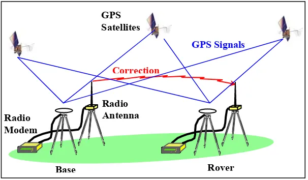
Rover Base
Correction
GPS Satellites
Radio Antenna
GPS Signals
Radio Modem
Further details of the system, its applicability, along with a complete description of the GPS signals, equipment, measurement procedures and basic equations can be found in Kaplan (2006); Hofman-Wellenhof et al. (1997) and Leick (2005).
3. REAL-TIME KINEMATIC GPS (RTK-GPS)
In static observation mode, GPS is capable of providing 0.05 Hz of sampling frequency with location precision of 5~10 mm. Nonetheless, static observation mode can only provide position information in post-processing mode. Apparently, with the advent of Real-Time Kinematic (RTK-GPS) technique, deformations of various structures such as dams, wide span bridges, highways and high rise buildings can be monitored instantaneously with an accuracy of 10 mm ± 1 to 2 ppm (horizontally) and 15-20 mm ± 2 ppm (vertically). RTK-GPS is one of the latest innovations of GPS relative positioning whereby the main concept behind RTK-GPS technique is errors in GPS observables are essentially identical at both receivers (base and rover). Two dual frequencies receivers are linked by radios simultaneously during field observations i.e. base and rover receiver(s). Equipped with radio instrumentation setup (i.e. radio modem and radio antenna), the base receiver is located over a known control point (i.e. benchmark) throughout the duration of the survey. The base receiver transmits correction in a standard format namely Radio Technical Commission for Maritime Service (RTCM) to rover receiver through the use of radio system. Figure 1 illustrates the overview of RTK-GPS technique.
Figure 1. RTK-GPS Overview
The main advantage of RTK-GPS technique is unlike static or any other GPS conventional method, this technique is capable of providing position information instantaneously while in the field in which leads to a higher productivity compared to the post-processing mode. Nonetheless, RTK-GPS requires dual frequencies receivers and radio instrumentation to be set at both reference and roving stations. Even though in term of accuracy, post-processing technique provides better result compared to RTK-GPS, for the purpose of structural health detection, an accuracy of 10 mm ± 1 to 2 ppm (horizontally) and 15-20 mm ± 2 ppm (vertically) provided by RTK-GPS technique are sufficiently enough and still within the acceptable limit.
4. SIMULATION TEST
health detection, well-calibrated GPS Trimble™ 4800 dual-frequency receivers and Pacific Crest™ radio modems were used in this study. By applying static survey mode to determine true coordinates in which will be used latter as “reference”, the test is then conducted in real-time using RTK-GPS mode.
4.1 Static Surveying
Two epochs of static surveying method is applied to determine the position (true coordinate) of two selected reference points namely P1 and P2 (see Figure 2). Using three GPS Trimble™ 4800 receivers, the field observation was carried out for about one hour per epoch. This survey involved three GPS Trimble™ 4800 receivers. Table 1 entails the parameters used during the static field observation.
Figure 2. Location of Point P1 and P2
Table 1: Static Surveying Observation Parameters
No Items Assigned Parameter
1 Cut-off angle 15 degrees 2 Data interval 15 seconds 3 Coordinate system WSG 84 4 Datum MRT 1994
4.2 RTK-GPS Surveying
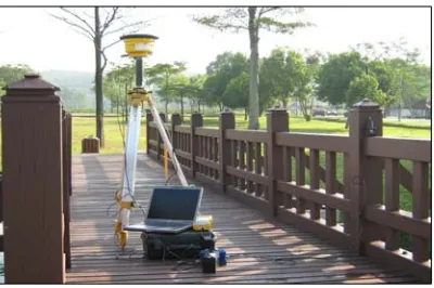
For the purpose of utilizing RTK-GPS technique, PacificTM Cress type of radio link has been used in
addition to two TrimbleTM 4800 dual frequency receivers. For real time data display, real time
processing scheme was adopted where positioning data from the rover is recorded directly to an on-site notebook running LabVIEWTM software. Data was collected at 1 Hz for about 15 minutes. Figure
3 illustrates the connection setup between rover receiver and laptop at P1 station.
Figure 3. Overview of Instrumentation Setup
5. ANALYSIS OF RESULT
As mentioned earlier, two epochs of static surveying technique have been conducted to establish the true positions (coordinates) of the monitoring points on the bridge (P1 and P2). The static survey was then processed and adjusted using TrimbleTM Geomatic Office v1.6 software. The adjusted geodetic
coordinates from the network adjustment is as tabulated in Table 2.
Table 2: True Coordinates of GPS Monitoring Points
Point Name Latitude (N) Longitude (E) Height (m)
BASE 1°33'14.30574" 103°38'17.83999" 21.900
P1 1°33'17.60316" 103°38'17.22900" 19.925
P2 1°33'17.73936" 103°38'17.34540" 19.830
The results for RTK-GPS were illustrated in Table 3 and 4. These tables show the variation of coordinates at the two monitoring points (P1 and P2) compared to the true values listed in Table 2. Table 3 and 4 demonstrate the simple analysis for point P1 and P2, respectively.
Table 3. Analysis for Point P1
Point P1 Northing (m) Easting (m) Height (m) True value (TV) 171946.676 627036.822 12.294 Min value 171946.673 627036.822 12.279 Max value 171946.682 627036.840 12.309
TV-Min 0.003 0.000 0.015
TV-Max -0.006 -0.018 -0.015
Max-Min 0.009 0.018 0.030
RMS (m) 0.000 0.001 0.006
Table 4. Analysis for Point P2
Point P2 Northing (m) Easting (m) Height (m) True value (TV) 171950.857 627040.422 12.199 Min value 171950.854 627040.422 12.190 Max value 171950.862 627040.440 12.216
TV-Min 0.003 0.000 0.009
TV-Max -0.005 -0.018 -0.017
Max-Min 0.008 0.018 0.026
RMS (m) 0.001 0.002 0.006
detected at the bridge. It is also suggested that the structural health of the bridge is in a satisfactory condition.
6. CONCLUSION
As safety precautions, the need for rapid assessment of the state of large engineering structure after extreme events such as earthquake, tsunami, typhoon or related wind effects is highly demanded. With recent advances on Global Positioning System (GPS) receiver’s technology and data processing software during the past decade, the accuracy of positioning is improving distinctly up to only few millimeters by using a differential GPS carrier-phase approach. Despite of being expensive, in long term aspect, GPS is still an efficient and cost-effective tool in which can be well-integrated into an automated continuously operating system. Compared to other conventional method, it is noted that GPS through the utilization of RTK-GPS is potentially capable of being deployed as an effective tool in structural health detection.
ACKNOWLEDGEMENT
The work reported here is a part of the “ An Investigation on the Real-time Structural Health Monitoring System Using Space-based Technique “ project supported by the Fundamental Research Grant Scheme of the Ministry of Higher Education, Malaysia.
REFERENCES
Ashkenazi, V., Dodson, A.H., & Roberts, G.W. (1998). Real-Time Monitoring of Bridges by GPS. FIG XXI International Congress, pp. 503-512. Brighton, England.
Breuer, P., Chmielewski, T., Gorski, P., & Konopka, E. (2002). Application of GPS technology to measurements of displacements of high-rise structures due to weak winds. Journal of Wind Engineering and Industrial Aerodynamics 90(3), 223-230.
Guochang, X. (2003). GPS Theory, Algorithms and Applications. Springer, Berlin.
Hofmann-Wellenhof, B., and Lichtenegger, H. (1997). GPS Theory and Practice, Springer- Verlag, Wien Austria.
Kaplan, E. D., and Hegarty, C. J. (2006). "Understanding GPS: Principles and Applications, 2nd Edition." Artech House, Boston, USA, 703.
Leach, M.P., & Hyzak, M.D. (1994). GPS Structural Monitoring as Applied to a Cable-Stayed Suspension Bridge. FIG XX-International Congress, pp. 606.602/601-606.602/612. Melbourne, Australia.
Leick, A. (1995). GPS Satellite Surveying, Wiley, New York , Chichester,Brisbane, Toronto and Singapore.
Lovse, J.W., Teskey, W.F., & Lachapelle, G. (1995). Dynamic Deformation Monitoring of Tall Structure Using GPS Technology. Journal of Surveying Engineering 121(1), 35-40.
Mat Amin, Z., & Wan Akib, W.A. (2003). Experimental Detection Of The Penang Bridge Vibration With Real Time Kinematic GPS. Proc. International Symposium & Exhibition on Geoinformation, 2003, pp. 241-246. Shah Alam, Selangor.
Mat Amin, Z., Wan Akib, W. A., Setan, H., Nordin, Z., (2007). Virtual Instrument Platform and Global Positioning System for Real-time Monitoring of Structures. International Symposium & Exhibition on Geoinformation, 2007, Pesada Johor, Johor.
Nakamura, S.-i. (2000). GPS Measurement of Wind-Induced Suspension Bridge Girder Displacements. Journal of Structural Engineering 126(12), 1413-1419.
Tamura, Y., Matsui, M., Pagnini, L.-C., Ishibashi, R., & Yoshida, A. (2002). Measurement of wind-induced response of buildings using RTK-GPS. Journal of Wind Engineering and Industrial Aerodynamics 90(12-15), 1783-1793.
Wan Akib, W. A., Othman, Z. and Najib, H. (2001). ’Monitoring High Rise Building Deformation Using Global Positioning System’. The Asian GPS Conference 2001 Proceedings.