Multi-Jurisdictional Natural Hazards Mitigation Plan
Harney County
Harney County
Natural Hazards Mitigation Plan
Report for:
Harney County 450 N Buena Vista Burns, OR 97720
Prepared by:
Oregon Natural Hazards Workgroup
Community Service Center 1209 University of Oregon Eugene • Oregon • 97403-1209
Special Thanks &
Acknowledgements
Project Steering Committee:
Fred Flippence, Harney Electric Cooperative Steve Grasty, Harney County Court
Brandon McMullen, Harney County Planning Department David Justin Boone, City of Burns
Pamela Mather, City of Hines Ruth Schultz, City of Hines
Kenton Dick, Paiute Native American Tribe
Mike Williams, Bureau of Land Management, Burns District William Huber, US Forest Service
Carey Goss, US Fish and Wildlife Service
Project Managers:
A. Gregoor Passchier, Oregon Natural Hazards Workgroup Krista Mitchell, Oregon Natural Hazards Workgroup
This Natural Hazards Mitigation Plan was developed through a regional
partnership funded by the Federal Emergency Management Agency’s Pre-Disaster Mitigation Competitive Grant Program. The Southeast Oregon Region grant was awarded to support the development of natural hazard mitigation plans for the region. The region’s planning process utilized a four-phased planning process, plan templates and plan development support provided by the Oregon Natural Hazards Workgroup at the University of Oregon.
Regional partners include:
• Federal Emergency Management Agency Region 10;
• Oregon Emergency Management;
• Oregon Department of Geology and Mineral Industries;
• Oregon Natural Hazards Workgroup at the University of Oregon’s Community Service Center;
• Resource Assistance for Rural Environments at the University of Oregon’s Community Service Center;
• Harney County;
• Jefferson County;
• Lake County, and
Harney County
Natural Hazards Mitigation Plan
Table of Contents
Volume I: Natural Hazard
s
Mitigation Plan
Executive Summary ………i
Section 1: Introduction………. 1-1
Section 2: Community Sensitivity and Resilience ………2-1
Section 3: Risk Assessment Summary ………... .3-1
Section 4: Mission, Goals, and Action Items ………..4-1
Section 5: Plan Implementation and Maintenance ………5-1
Volume II: Addendums
Burns City Addendum ………BC-1
Hines City Addendum ………HC-2
Harney Electric Cooperative Addendum………HEC-3
Volume III: Resources
Appendix A: Planning and Public Process ……….A-1
Appendix B: Hazard Annexes……….B-1
Appendix C: Economic Analysis ………..C-1
Appendix D: Household Survey……….D-1
Appendix E: Community Organizations ……….E-1
Appendix F: Resource Directory ……….F-1
Appendix G: Success Template ...…..……….G-1
Executive Summary
Harney County developed this Natural Hazards Mitigation Plan in an effort toreduce future loss of life and property resulting from natural disasters. It is
impossible to predict exactly when these disasters will occur, or the extent to which they will affect the community. However, with careful planning and collaboration among public agencies, private sector organizations, and citizens within the community, it is possible to minimize the losses that can result from natural disasters.
Natural hazard mitigation is defined as a method of permanently reducing or alleviating the losses of life, property, and injuries resulting from natural hazards through long and short-term strategies. Example strategies include policy changes, such as updated ordinances, projects, such as seismic retrofits to critical facilities; and education and outreach to targeted audiences, such as Spanish speaking residents or the elderly. Natural hazard mitigation is the responsibility of
individuals, private businesses and industries, state and local governments, and the federal government.
Why Develop this Mitigation Plan?
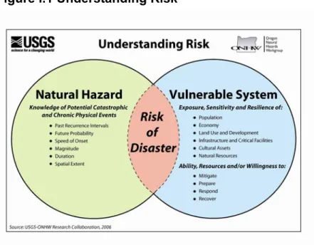
This natural hazard mitigation plan is intended to assist Harney County to reduce the risk from natural hazards by identifying resources, information, and strategies for risk reduction. It will also help guide and coordinate mitigation activities throughout the community. The figure below is utilized throughout the plan to illustrate the concept of risk reduction.
Figure i.1 Understanding Risk
A natural hazard mitigation plan can assist the community to understand what puts the community at risk. When a community can identify and understand the relationship between the natural hazards it faces, its vulnerable systems, and its existing capacity, it becomes better equipped to identify and implement actions aimed at reducing the community’s overall risk to natural hazards.
Who Participated in Developing the Plan?
In Fall 2005, the Oregon Natural Hazards Workgroup (ONHW) at the University of Oregon’s Community Service Center partnered with the Department of Geology and Mineral Industries (DOGAMI) and the Southeast Oregon Region (Harney and Malheur as well as Jefferson and Lake) counties to develop a Pre-Disaster
Mitigation Planning Grant proposal. Each county joined the Partnership for Disaster Resistance and Resilience (The Partnership) by signing (through their County Commissions) a Memorandum of Understanding for this project. FEMA awarded the Southeast Oregon Region grant to support the development of the natural hazard mitigation plans for the four counties in the region. ONHW, DOGAMI and the communities were awarded the grant in the Fall of 2005 and local planning efforts in this region began in the Fall of 2006.
The Harney County Natural Hazard Mitigation Plan is the result of a collaborative effort between citizens, public agencies, non-profit organizations, the private sector and regional organizations. A project steering committee guided the process of developing the plan. The steering committee was comprised of representatives from the following organizations.
• Harney County Court;
• Harney County Planning Department;
• Harney Electric Cooperative;
• City of Burns;
• City of Hines;
• United States Forest Service;
• Bureau of Land Management;
• US Fish and Wildlife Service; and
• Paiute Indian Tribe.
The Harney Electric Cooperative was designated as the plan’s convener and will take the lead in implementing, maintaining and updating the plan. Public
participation played a key role in the development of goals and action items. Public participation was achieved with the establishment of the Harney County Natural Hazards Mitigation Steering Committee, which was comprised of community members representing different organizations and sectors in Harney County. The Steering Committee was closely involved throughout the development of the plan and served as the local oversight body for the plan’s development. In addition, community members outside of the steering committee were involved in the planning process.
What is the Plan’s Mission?
The mission of the Harney County Natural Hazards Mitigation Plan is to create a disaster-resilient Harney County. This mission statement is intended to be a timeless statement that is adaptable to any future changes made to the plan. It was developed in collaboration with the Harney County Natural Hazards Mitigation Steering Committee members.
What are the Plan Goals?
The plan goals describe the overall direction that Harney County’s agencies, organizations, and citizens can take toward mitigating risk from natural hazards. The goals for the Harney County Natural Hazards Mitigation Plan were developed based on the needs identified by community members. ONHW, together with Steering Committee members developed the following goals for the Mitigation Plan:
• Save lives and reduce injuries.
• Minimize and prevent damage to public and private buildings and infrastructure.
• Increase cooperation and coordination among local, state, and federal agencies.
• Reduce economic loss.
• Protect natural resources.
• Protect cultural resources.
How are the Action Items Organized?
The action items are organized within an action matrix (located at the end of this Summary), which lists all the multi-hazard and hazard-specific action items included in the mitigation plan. Data collection and research and the public participation process resulted in the development of these action items. The Action Item Matrix portrays the overall plan framework and identifies linkages between the plan goals, and actions. The matrix documents a description of the action, the coordinating organization, timeline, and the plan goals addressed.
• Coordinating Organization: The coordinating organization is the public agency with regulatory responsibility to address natural hazards, or that is willing and able to organize resources, find appropriate funding, or oversee activity implementation, monitoring and evaluation.
• Internal Partners: Internal partner organizations are departments within the community that may be able to assist in the implementation of action items by providing relevant resources to the coordinating organization.
• External Partners: External Partner organizations can assist the
community in implementing the action items in various functions and may include local, regional, state, or federal agencies, as well as local and regional public and private sector organizations.
The internal and external partner organizations listed in the mitigation plan are potential partners recommended by the project steering committee, but who were not necessarily contacted during the development of the plan. Partner organizations
should be contacted by the coordinating organization to establish commitment of time and or resources to action items.
• Timeline: Action items include both short-term and long-term activities. Each action item includes an estimate of the timeline for implementation.
Short-term action items (ST) are activities which city agencies are capable of implementing with existing resources and authorities within one to two years. Long-term action items (LT) may require new or additional resources or authorities, and may take between one and five years to implement.
• Plan Goals Addressed: The plan goals addressed by each action item are identified as a means for monitoring and evaluating how well the mitigation plan is achieving its goals following the implementation.
How will the plan be implemented?
The plan maintenance section of this document details the formal process that will ensure that the Harney County Natural Hazards Mitigation Plan remains an active and relevant document. The plan maintenance process includes a schedule for monitoring and evaluating the Plan annually and producing a plan revision every five years. This section describes how the community will integrate public
participation throughout the plan maintenance process. Finally, this section intends to incorporate the mitigation strategies outlined in this Plan into existing planning mechanisms such as the Comprehensive Plan, Capital Improvement Plans, and Building Codes outlined in the Development Code.
Plan Adoption
The Harney Electric Cooperative and the Harney County Court, together with the Cities of Burns and Hines will be responsible for adopting the Harney County Natural Hazards Mitigation Plan and providing the support necessary to ensure plan implementation. This Plan is a multi-jurisdictional plan that covers information on natural hazards, vulnerabilities, and action items for the jurisdictions of Harney County, Burns, and Hines. The Plan also provides hazard and vulnerability information and action items for the Harney Electric Cooperative who is the coordinating organization for this Plan. After the Plan is locally reviewed and deemed complete, the Harney Electric Cooperative will be responsible for submitting it to the State Hazard Mitigation Officer at Oregon Emergency Management. Oregon Emergency Management will then submit the Plan to the Federal Emergency Management Agency (FEMA – Region X) for review. This review will address the federal criteria outlined in FEMA Interim Final Rule 44 CFR Part 201. Upon acceptance by FEMA the County and the cities will adopt the plan via resolution. At that point the County will gain eligibility for the Pre-Disaster Mitigation Grant Program, the Hazard Mitigation Grant Program funds, and the Flood Mitigation Assistance program funds.
The accomplishment of the Natural Hazards Mitigation Plan goals and actions depends upon the maintenance of a competent Steering Committee and adequate support from the county departments reflected in the plan in incorporating the outlined action items into existing county plans and procedures. It is hereby directed that the appropriate county departments and programs implement and maintain the concepts in this plan. Thorough familiarity with this Plan will result in the efficient
and effective implementation of appropriate mitigation activities and a reduction in the risk and the potential for loss from future natural hazard events.i
i
Harney County NHMP Action Item Matrix
Alignment with Plan Goals
Action Item Proposed Action Title
Coordinating
Organization
Partner
Organizations
Timeline
Sav e Liv es and Redu ce In jur ies Mi ni mi ze a n d pre v en t da mag e t o pu bl ic an d p ri v at e bui ld in gs a n d infra struct ure Inc rease c o ope ration and coordination a mong local, state, and
fede ral agencie s Red u ce economic lo ss
Protect natural resources Protect c
u
ltural res
o
urces
Flood # 1 Update the FEMA Firm
Floodplain maps.
Harney County Planning Department
Burns, Hines, Harney County, Paiute Tribe, DLCD, FEMA, OEM
LT X X
Flood # 2
Update regulations in the Harney County floodplain ordinance that incorporate no adverse impact (NAI) practices and address the construction of driveways and culverts in new developments.
Harney County Planning Department
Burns, Hines, County landowners, Harney County Watershed Council, Paiute Tribe, Cattleman Association, Harney County Watermaster, FEMA, DLCD ST X X X Flood # 3
Educate current homeowners and prospective buyers of property in Harney County about potential floodplain issues on their property and actions they can implement to mitigate the impacts of a flood.
Harney County Planning Department
Burns, Hines, Paiute
Tribe, DLCD, FEMA ST X X
Flood # 4
Explore the possibility of joining the National Flood Insurance Program (NFIP) Community Rating System (CRS) to reduce NFIP premiums.
Harney County Planning Department
Burns, Hines, Paiute
Flood # 5
Develop mitigation actions for repetitive flood loss properties and single loss properties that will reduce the impact of floods.
Harney County Planning Department
Burns, Hines, Paiute
Tribe, DLCD, FEMA LT X
Wildfire # 1
Revise and update
subdivision/partition ordinances to incorporate wildfire mitigation measures to prevent future losses from wildfire.
Harney County Planning Department
Burns, Hines, Paiute Tribe, DLCD, Oregon Department of Forestry (ODF)
ST X X
Wildfire # 2
Continue cooperation among the Burns Interagency Fire Zone (BIFZ), Oregon Department of Forestry (ODF), Burns and Hines Fire Departments, US Fish and Wildlife Service, Burns Paiute Indian Reservation, the Rangeland Fire Protection Associations, (RFPA), and private landowners concerning wildfire issues as outlined in the CWPP.
Harney County CWPP Core Team
Harney County, Burns, Hines, Paiute Tribe, Rural Fire Protection Association, ODF, United States Fish and Wildlife Service (USFWS)
ST X X
Wildfire # 3
Conduct the Community Firewise Outreach program annually, as outlined in the Harney County CWPP, to encourage residents to create a defensible space around their residences and teach residents about the long-term investment to increase fire safety.
Harney County CWPP Core Team
Harney County, Burns, Hines, Paiute Tribe, BLM, Forest Service
LT X X
Wildfire # 4
Strengthen the Rangeland Fire Protection Associations (RFPAs) capacity to ensure the quality of fire protection service throughout Harney County as detailed in the CWPP.
Harney County CWPP Core Team
Harney County, Burns, Hines, Paiute Tribe, ODF, National Fire Protection Association (NFPA)
ST X X
Wildfire # 5
Provide supplemental water supply tanks in key locations to ensure availability of water throughout the county.
Harney County CWPP Core Team
Harney County, Burns, Hines, Paiute Tribe, FEMA, ODF
Wildfire # 6
Use the Community Wildfire Protection Plan’s Core Team to coordinate response efforts among federal, state, and county agencies to ensure that wildfire response efforts are effective in the county.
Harney County CWPP Core Team
Harney County, Hines, Burns, Paiute Tribe, BLM, Forest Service, FEMA, ODF
LT X
Wildfire # 7
Develop and implement fuel reduction strategies to manage forest health and reduce the likelihood of large-scale wildfires in the Emigrant Creek Ranger District and the Burns BLM District lands.
Harney County
Harney County, Burns, Hines, Paiute Tribe, Nature Conservancy, Forest Service, BLM
LT X X X
Wildfire # 8
Construct fuel breaks and manage hazardous fuels as delineated in the Community Wildfire Protection Plan (CWPP) to break up the continuity of wildland fuel near major population centers.
CWPP Core Team
Burns, Hines, Harney County, Paiute Tribe, FEMA, Forest Service, BLM
LT X X
Wildfire # 9
Construct barriers on pole power transformers to prevent birds from building nests on them, thereby reducing the chance of wildfires from transformer shorts.
Harney Electric Cooperative
County, Burns, Hines, Paiute Tribe, Audubon Society, Harney County National Wildlife Refuge, Nature Conservancy
LT X
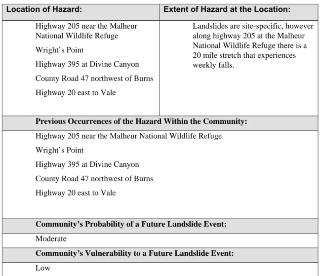
Landslide # 1
Make ODOT aware of the landslide issues on Highway 205 at the NWR near Frenchglen, Highway 395 at Divine Canyon, and County Road 47.
Harney County Road Department
Harney County, Oregon Department of
Transportation (ODOT)
ST X X
Severe Weather # 1
Educate residents and visitors to Harney County about the dangers of lightening strikes, flash floods, and severe weather in the high desert. Harney County Chamber of Commerce Harney County Planning Department, Hunter’s Booth Coordinators, BLM, Forest Service, Oregon Hunter’s Association
Severe Weather # 2
Replace primary electrical overhead lines to mountaintop communication services with underground lines.
Harney Electric Cooperative, Inc
Oregon Trail Electric Cooperative,
Companies which are served by the utility and the utility company, Malheur County, Lake County
LT X X
Severe Weather # 3
Shorten spans and anchor poles on utility lines in high wind or heavy icing areas.
Harney Electric Cooperative, Inc.
Oregon Trail Electric Cooperative, Malheur County, Lake County
LT X
Earthquake # 1 Inventory and identify critical
facilities for seismic retrofit.
Harney County School District No. 3
Burns, Hines, Harney County, Crane School District, DOGAMI, OEM
LT X
Drought # 1
Conduct public outreach campaigns to raise awareness about drought hazards and mitigation actions residents can take to reduce the impact of drought on the county.
Harney County Watershed Council
Burns, Hines, Harney County, Paiute Tribe, Natural Resources Conservation Services, Oregon Department of Agriculture ST X Multi-Hazard # 1
Educate residents about preparing emergency kits and stocking a 14-day supply of food to adequately prepare for a natural hazard event.
Harney County Health Department
Burns, Hines, Paiute Tribe, Harney County, Senior Center (food bank), OEM
ST X
Multi-Hazard # 2
Work with local businesses to develop business continuity plans. Harney County Economic Development (HCED) Harney County Chamber of Commerce, Oregon Cattleman’s Association, Oregon Natural Hazards Workgroup (ONHW) LT X Multi-Hazard # 3
Inventory historic and cultural resources, with an emphasis on unreinforced masonry buildings, and identify their vulnerabilities to natural hazards to develop mitigation actions for their protection.
Harney County Chamber of Commerce
Burns, Hines, Paiute Tribe, Harney County, Oregon State Historic Preservation Office (SHPO), Forest Service, BLM, USFWS LT X X Multi-Hazard # 4 Develop a Continuity of Operations Plan (Coop) for Harney County.
Harney County Burns, Hines, Paiute
Plan Implementation
# 1
The Harney County Natural Hazards Mitigation Steering Committee will be the
coordinating body responsible for implementing the Harney County Natural Hazards Mitigation Plan.
Harney County Natural Hazard Mitigation
Coordinating Body
Burns, Hines, Harney County Planning Department, Harney County Court, Paiute Tribe, US Forest Service, BLM, USFWS ST X Plan Implementation # 2
Coordinate mitigation planning activities with existing planning activities to incorporate mitigation actions and avoid duplicating efforts.
Harney County Hazard Mitigation Coordinating Body
Harney County, Burns, Hines, Paiute Tribe, CWPP Core Team, Harney County Health Department, Forest Service, BLM, Oregon Department of Health ST X Plan Implementation # 3
Use the services of the Harney County Emergency Manager to assist in coordinating hazard mitigation meetings and in implementing mitigation action items.
Harney County Hazard Mitigation Coordinating Body
Harney County, Burns, Hines, Paiute Tribe, OEM
Volume I:
Natural Hazards Mitigation Plan
Executive Summary
Section 1: Introduction
Section 2: Community Sensitivity and Resilience
Section 3: Risk Assessment Summary
Section 4: Mission, Goals, and Action Items
Section 1
Introduction
What is Natural Hazard Mitigation?
Natural hazard mitigation is defined as permanently reducing or alleviating the losses of life, property and injuries resulting from natural hazards through long and short-term strategies. Example strategies include policy changes, such as updated ordinances; projects, such as seismic retrofits to critical facilities; education and outreach to targeted audiences, such as Spanish speaking residents, or the elderly. Mitigation is the responsibility of individuals, private businesses and industries, state and local governments, and the federal government.i
Engaging in mitigation activities provides jurisdictions with a number of benefits, including reduced loss of life, property, essential services, critical facilities and economic hardship; reduced short-term and long-term recovery and reconstruction costs; increased cooperation and communication within the community through the planning process; and increased potential for state and federal funding for recovery and reconstruction projects.
Why Develop a Mitigation Plan?
Harney County, together with the Harney Electric Cooperative and the cities of Burns and Hines, developed this multi-jurisdictional Natural Hazard Mitigation Plan in an effort to reduce future loss of life and damage to property resulting from natural hazards. It is impossible to predict exactly when these hazards will occur, or the extent to which they will affect the County. However, with careful planning and collaboration among public agencies, private sector organizations, and citizens within the community, it is possible to minimize the losses that can result from natural hazards.
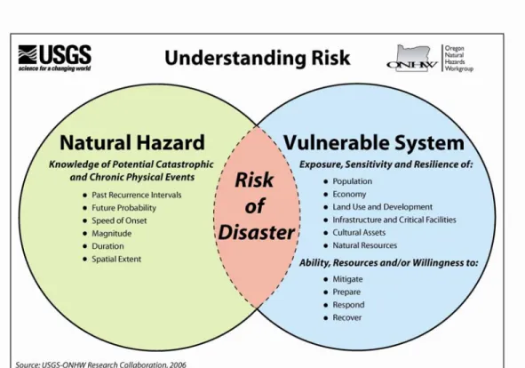
Natural disasters occur as a predictable interaction among three broad systems: natural environment (e.g., climate, river systems, geology, forest ecosystems, etc.), the built environment (e.g., cities, buildings, roads, utilities, etc.), and societal systems (e.g. cultural institutions, community organizations, business climate, service providers, etc.) as is depicted in Figure 1.1 below. A natural disaster occurs when a natural hazard impacts the built environment or societal systems and creates adverse conditions within a community.ii
Figure 1.1 Understanding Risk
Source: Oregon Natural Hazards Workgroup
This multi-jurisdictional plan focuses on the primary natural hazards that could affect Harney County, Oregon, the cities of Burns and Hines, and the Harney Electric Cooperative, including wildfire, flood, and severe weather events. Although the plan focuses on these three events, it also addresses earthquake, landslide, volcanic, and drought hazards in the county. The dramatic increase in the costs associated with natural disasters over the past decades has fostered interest in identifying and implementing effective means of reducing vulnerability. A report submitted to Congress by the National Institute of Building Science’s Multi-hazard Mitigation Council (MMC) highlights that for every dollar spent on mitigation, society can expect an average savings of $4.iii This Natural Hazards Mitigation Plan is intended to assist Harney County, the cities of Burns and Hines, and the Harney Electric Cooperative in reducing its risk from natural hazards by identifying resources, information, and strategies for risk reduction.
The plan is strategic and non-regulatory in nature, meaning that it does not necessarily set forth any new policy. It does, however, provide: (1) a foundation for coordination and collaboration among agencies and the public in the County; (2) identification and prioritization of future mitigation activities; (3) aid in meeting federal planning requirements and qualifying for assistance programs. The mitigation plan works in conjunction with other County plans and programs including, the Harney County Comprehensive Plan, the Harney County
Transportation Plan, the Harney County Zoning Ordinance, the Harney County Subdivision and Partition Ordinance, the Harney County Emergency Operations Plan, as well as the State of Oregon Natural Hazards Mitigation Plan.
The plan provides a set of actions to prepare for and reduce the risks posed by natural hazards through education and outreach programs, the development of partnerships, and the implementation of preventative activities such as land use or watershed management programs and infrastructure improvements. The actions described in the plan are intended to be implemented through existing plans and programs within the County.
Policy Framework for Natural Hazards in
Oregon
Planning for natural hazards is an integral element of Oregon’s statewide land use planning program, which began in 1973. All Oregon cities and counties have comprehensive plans and implementing ordinances that are required to comply with the statewide planning goals. The challenge faced by state and local governments is to keep this network of local plans coordinated in response to the changing conditions and needs of Oregon communities.
Statewide land use planning Goal 7: Areas Subject to Natural Hazards calls for local plans to include inventories, policies and ordinances to guide development in hazard areas. Goal 7, along with other land use planning goals, has helped to reduce losses from natural hazards. Through risk identification and the
recommendation of risk-reduction actions, this plan aligns with the goals of the jurisdiction’s comprehensive plan, and helps each jurisdiction meet the
requirements of statewide land use planning Goal 7.
The primary responsibility for the development and implementation of risk reduction strategies and policies lies with local jurisdictions. However, resources exist at the state and federal levels. Some of the key agencies in this area include Oregon Emergency Management (OEM), Oregon Building Codes Division (BCD), Oregon Department of Forestry (ODF), Oregon Department of Geology and Mineral Industries (DOGAMI), and the Department of Land Conservation and Development (DLCD).
The Disaster Mitigation Act of 2000 (DMA 2000) is the latest federal legislation addressing mitigation planning. It reinforces the importance of mitigation planning and emphasizes planning for disasters before they occur. As such, this Act established the Pre-Disaster Mitigation (PDM) grant program and new requirements for the national post-disaster Hazard Mitigation Grant Program (HMGP). Section 322 of the Act specifically addresses mitigation planning at the state and local levels. State and local communities must have approved mitigation plans in place in order to qualify to receive post-disaster HMGP funds. Mitigation plans must demonstrate that their proposed mitigation measures are based on a sound planning process that accounts for the risk to the individual and their capabilities.
How was the Plan Developed?
In Fall 2005, the Oregon Natural Hazards Workgroup (ONHW) at the University of Oregon’s Community Service Center partnered with the Department of Geology and Mineral Industries (DOGAMI) and the Southeast Oregon Region (Harney and Malheur as well as Jefferson and Lake) counties to develop a Pre-Disaster
Disaster Resistance and Resilience (The Partnership) by signing (through their County Commissions) a Memorandum of Understanding for this project. FEMA awarded the Southeast Oregon Region a grant to support the development of the natural hazard mitigation plans for the four counties in the region. ONHW, DOGAMI, and the participating communities were awarded the grant in the Fall of 2005 and local planning efforts in this region began in the Fall of 2006.
ONHW provided participating communities with print and web-based resources and facilitated a quarterly series of plan development work sessions that focused on the four phases of the mitigation planning process. In addition, ONHW also provided communities with a number of regional mitigation products to be utilized in the local process. Those products include:
• Plan Templates; • Training Manual;
• Regional Profile and Risk Assessment; and • Household Preparedness Survey Report.
DOGAMI provided communities with updated risk assessment data to be utilized in the local planning process. DOGAMI’s efforts include updating the Regional Risk Assessment of the State Natural Hazard Mitigation, completion of the HAZUS model for earthquake losses, and identification of existing state and federal hazards data.
Each community is responsible for facilitating the mitigation planning process locally, utilizing the resources provided by ONHW, DOGAMI and other state partners. The community reviewed the resources provided by the various
organizations and applied local knowledge, information and data about community characteristics, assets and resources in order to identify potential mitigation actions aimed at reducing the community’s overall risk.
The planning process used to create Harney County’s Natural Hazards Mitigation Plan was developed using a planning process created by the Community Service Center’s Oregon Natural Hazard Workgroup at the University of Oregon.iv The planning process was designed to: (1) result in a plan that is DMA 2000 compliant; (2) coordinate with the State’s plan and activities of the Partners for Disaster Resistance & Resilience; and (3) build a network of jurisdictions and organizations that can play an active role in plan implementation. The planning process included the review and incorporation, if appropriate, of existing plans, studies, reports and technical information. In general, the following regional resources were reviewed and local resources have been cited throughout the plan.
• State of Oregon Natural Hazard Mitigation Plan – Regional Profiles and Hazard Assessments;
• Oregon Technical Resource Guide;
• Oregon Natural Hazards Workgroup Training Manual; • The Oregon Atlas;
• The Oregon Weather Book;
• Harney County Subdivision Ordinance; and • Region 8 Household Preparedness Survey Report.
The following is a summary of major activities included in the planning process.
Phase I: Getting Started
In December 2006, the Harney Electric Cooperative signed a memorandum of agreement with the Oregon Partners for Disaster Resistance and Resilience to lead the development of a Natural Hazards Mitigation Plan for Harney County. The Oregon Natural Hazards Workgroup hired a graduate student (A. Gregoor
Passchier, Graduate Teaching Fellow for the Oregon Natural Hazards Workgroup) to manage the hazard mitigation planning process as well as plan and facilitate community meetings. ONHW staff (Krista Mitchell, ONHW Assistant Director, and André LeDuc ONHW Director) assisted in developing the plan and facilitating the planning process. The Harney Electric Cooperative (Fred Flippence, Harney Electric Cooperative Office Manager) served as the primary local contact, identifying steering committee members for community meetings, organizing community meetings, and fielding any questions local community members had about the planning process. In addition, the Harney Electric Cooperative served as chair for all steering committee meetings.
In January 2007, the Harney Electric Cooperative identified community members to serve as members of the Harney County Mitigation Steering Committee. The steering committee functioned as the community body responsible for overseeing the mitigation planning process, and included representatives from the following organizations:
•
US Forest Service;•
Bureau of Land Management;•
Harney County Court;•
Harney County Planning Department;•
Malheur National Wildlife Refuge;•
City of Hines;•
City of Burns; and•
Burns Paiute TribeThe committee members worked collaboratively with the Electric Cooperative and ONHW to provide local input and feedback to the planning process. On February 9, 2007 the steering committee met for the first time to discuss hazard mitigation in Harney County and the roles and responsibilities expected of committee members and of ONHW. ONHW facilitated the discussion while the Harney Electric Cooperative served as the committee chair. An agenda and a sign-in sheet for this meeting are available in the Appendix A: Planning and Public Process.
Participation among key community members in steering committees served as the primary method for ensuring public participation during Phase I. The Harney Electric Cooperative and ONHW invited community members and stakeholders from around Harney County to participate in the planning process and provide representation from their organization’s point of view. Appendix A: Public
Process lists the participating members. Committee members were also encouraged to speak with their local representatives to inform them of the mitigation planning process currently being undertaken by their organization. In addition, as part of the regional PDM grant, ONHW implemented a region-wide household preparedness survey where the public could provide input to the plan regarding their natural hazards. The survey gauged household knowledge of mitigation tools and techniques and assessed household disaster preparedness. The survey results improve public/private coordination of mitigation and preparedness for natural hazards by obtaining more accurate information on household
understanding and needs. Results of the survey are documented in an independent report in Appendix D Household Preparedness Survey.
To supplement information gathered from Steering Committee members, ONHW also conducted stakeholder interviews with the following organizations in Harney County:
• Harney County Planning Department • Bureau of Land Management
• US Forest Service
• Harney Electric Cooperative • Harney County Health Department • City of Hines
• City of Burns
Interviews conducted with the above organizations provided information on the extent of natural hazards found within Harney County, as well as information on mitigation or other emergency management planning efforts being undertaken within the county.
The County’s project webpage located on the Partners for Disaster Resistance and Resilience website (www.OregonShowcase.org) served as an outreach tool to the community. The webpage was used to provide local contact information and updates on the planning process. The final adopted and approved plan will be posted on the Partnership website via the University of Oregon Libraries’ Scholar’s Bank Digital Archive.
Phase II: Risk Assessment
The plan’s risk assessment is documented in three individual components within the plan. First, the community’s vulnerability in terms of community assets and resources at risk as well as existing capabilities to address mitigation are
documented in Section 2 – Community Sensitivities and Resilience. Second, the hazards impacting the community are identified and profiled in Section 3 – Risk Assessment Summary. Third, each hazard addressed in the plan has an
accompanying hazard annex which includes information on hazard specific ordinances, plans or studies, after-incident reports, and any relevant hazard maps. All three of these components together help to define the community’s risk, as is depicted in Figure 1.1.
ONHW completed the community participatory elements of Phase II in two back-to-back meetings in March 2007.
On March 28, 2007, ONHW facilitated a community asset identification workshop to identify important assets in Harney County. The asset identification workshop focused on the following five themes:
•
Population•
Economy•
Critical Facilities and Infrastructure•
Historic and Cultural Resources•
EnvironmentalThirteen community members representing different segments in Harney County attended the meeting to provide community input. Including community members outside of the Steering Committee for the workshop served as the primary means for public participation in this meeting (see Appendix A: Planning and Public Process for an agenda, meeting notes, and a list of participants).
To assist in information gathering, ONHW distributed worksheets that listed a series of questions for each of the five themes. Participants had a few moments to write down their ideas and then later shared them with the group. The worksheets were also distributed to participants several weeks prior to the meeting to help facilitate discussion among community members (see Appendix A: Planning and Public Process, Community Assets Workshop Notes for a summary of the meeting notes).
The following day, on March 29, 2007, ONHW facilitated a hazard identification workshop with steering committee members and several community members to discuss the primary hazards affecting Harney County (see Appendix A: Public Process Annex for an agenda, meeting notes, and a participant list). ONHW, together with DOGAMI, presented geographic features for each natural hazard as well as the local hazard history in Harney County. ONHW then discussed with committee members potential impacts of the hazard on the county. Finally, committee members rated the three most significant natural hazards affecting Harney County using sticker dots. The three most concerning hazards committee members identified are the following:
1. Wildfire 2. Flood
3. Severe Weather events
The hazards listed above are rated by priority, with wildfire being the most concerning hazard of the three.
The risk and vulnerability assessments provided in the plan are a combination of the State of Oregon’s Natural Hazard Mitigation Plan (NHMP) Risk Assessment for Harney County and local information. The State of Oregon NHMP provides risk and vulnerability assessments for drought, wildfire, flood, landslides, windstorms, and winter storms. The information provided by the state is
members familiar with hazards in the county and their potential impact on certain segments of the population. For example, flooding was identified in Harney County as having a significant impact on residents in some county housing developments.
Harney County is vulnerable to a number of different natural hazards. Based on the risks assessments included in this plan, the primary natural hazards that affect Harney County include:
• Wildfire • Flood • Drought • Severe Weather
Other hazards, such as earthquake and volcano, affect Harney County to a lesser extent, but should they occur elsewhere in the state, they could have an indirect impact on the county.
Phase III: Developing a Mission, Goals and Action Items
The Plan’s mission statement and goals direct the Plan’s action items and reflect the priorities found in the community. ONHW, in consultation with the Harney County Mitigation Steering Committee, developed a mission statement and goals for the plan. On June 28, 2007, ONHW facilitated the Mission, Goals, and Action Items Steering Committee Meeting, chaired by the Harney Electric Cooperative, where Steering Committee members conducted a final review and approved the stated goals and action items. (For an agenda and participant list, see Appendix A: Planning and Public Process in this plan) The mission statement for the Plan, while simple, is intended to be a timeless statement that can withstand any changes the plan may undergo over time. The goals reflect the broad needs found within the community.
In addition to the mission and goals, the Mitigation Plan also includes action items which are specific mitigation activities the county can implement to reduce its vulnerability to natural hazards. ONHW, in consultation with the Harney County Mitigation Steering Committee, identified actions based on previous Steering Committee meetings and stakeholder interviews. At the June 28, 2007 Mission, Goals, and Action Items Steering Committee meeting, ONHW and Steering Committee members reviewed each action item and approved them after necessary changes. The action items for the Harney County Natural Hazard Mitigation Plan address all major natural hazards identified in the plan and include a
comprehensive range of activities to be completed. The approved action items are found in Section 4 of this plan.
Phase IV: Plan Implementation and Maintenance
The implementation and maintenance structure for the Mitigation Plan relies on continued community involvement. On June 28, 2007, the Mitigation Steering Committee and ONHW met to discuss the plan implementation and maintenance process. The Steering Committee identified the Harney Electric Cooperative as the convener for organizing and prioritizing implementation of action items, and Steering Committee members as the members of the coordinating body to oversee implementation of the plan. The Steering Committee agreed that the coordinating
body will meet on a semi-annual basis to review the plan and review
implementation of the action items. The Steering Committee also agreed that continued public involvement is essential to maintaining the Plan and obtaining community support for mitigation action items.
How is the Plan Organized?
Each section of the mitigation plan provides specific information and resources to assist readers in understanding the hazard-specific issues facing Harney County, the cities of Burns and Hines,citizens, businesses, and the environment.
Combined, the sections work in synergy to create a mitigation plan that furthers the community’s mission to reduce risk and prevent loss from future natural hazard events. This plan structure enables stakeholders to use the section(s) of interest to them.
Section 1: Introduction
The Introduction briefly describes the County’s mitigation planning efforts and the methodology used to develop the plan.
Section 2: Community Sensitivity and Resilience
This section documents the community’s sensitivities – those community assets and characteristics that may be impacted by natural hazards, as well as community resilience – the ability to manage risk and adapt to hazard event impacts.
Examples of community sensitivity factors include human populations, the local economy, critical facilities and infrastructure, cultural and historic resources, and environmental assets. Community resilience factors include existing plans, policies, programs or community organizations that influence a community’s character, governance or growth trends.
Section 3: Risk Assessment Summary
This section describes the risk assessment process and summarizes the best available local hazard data. A hazard summary is provided for each of the hazards addressed in the plan. The summary includes hazard history, location, extent, probability and previous mitigation efforts.
Section 4: Mission, Goals and Action Items
This section documents the plan mission, goals, and actions and also describes the components that guide implementation of the identified mitigation strategies.
Section 5: Plan Maintenance
This section provides information on the implementation and maintenance of the plan. It describes the process for prioritizing projects, and includes a suggested list of tasks for updating the plan to be completed at the semi-annual and 5-year review meetings.
Hazard-Specific Annexes
The purpose of the hazard-specific annexes is to provide additional resources and documentation of the hazard. Where extensive local data is available, beyond the scope of information provided in Section 3, the additional local data is placed in the annex found in Appendix B of the plan. The hazard specific annexes included with this plan are the following:
• Flood;
• Landslide/Debris Flow;
• Volcanic Event;
• Wildfire;
City Addendums
The Harney County Natural Hazards Mitigation Plan is a multi-jurisdiction plan that includes addendums addressing natural hazards found in the cities of Burns and Hines and for the Harney Electric Cooperative. While the Mitigation Plan covers natural hazards found throughout the county, the addendums provide additional natural hazard information and action items specific to the cities of Burns, Hines, and for the Harney Electric Cooperative.
Resource Appendices
The resource appendices are designed to provide the users of the Harney County Natural Hazards Mitigation Plan with additional information to assist them in understanding the contents of the mitigation plan, and provide them with potential resources to assist with plan implementation.
Public Participation
Appendix A includes documentation of all the public processes utilized to develop the plan. It includes invitation lists, agendas, sign-in sheets, and summaries of Steering Committee meetings as well as any other public involvement methods.
Economic Analysis of Natural Hazards Mitigation Projects
Appendix C describes the Federal Emergency Management Agency’s (FEMA) requirements for benefit cost analysis in natural hazards mitigation, as well as various approaches for conducting economic analysis of proposed mitigation activities. This appendix was developed by the Community Service Center’s Oregon Natural Hazards Workgroup at the University of Oregon. It has been reviewed and accepted by the Federal Emergency Management Agency as a means of documenting how the prioritization of actions shall include a special emphasis on the extent to which benefits are maximized according to a cost benefit review of the proposed projects and their associated costs.
Regional Household Preparedness Survey
Appendix D includes the survey instrument and results from the household preparedness survey implemented by ONHW throughout the region. The survey aims to gauge household knowledge of mitigation tools and techniques to assist in reducing the risk and loss from natural hazards, as well as assessing household disaster preparedness.
Success Template
Appendix G includes the State of Oregon’s template for documenting mitigation successes. The templates provide a format communities can use to document successful mitigation projects they have completed, and may serve as the plan’s record of completed mitigation projects.
Independent Reports Referenced
The following reports were utilized to develop portions of the mitigation plan. These reports are not included as appendices to this mitigation plan, as they are either a component of the State’s approved enhanced mitigation plan or an independent report developed by partner agencies.
Regional Profile and Risk Assessment
This report was developed by the Community Service Center’s Oregon Natural Hazards Workgroup at the University of Oregon. This report serves as the nexus between the State Natural Hazard Mitigation Plan and local plans. A component of the State Plan, the report is utilized by local communities to identify specific issues locally and to develop potential action items. Communities review and update the data in the report based on their best available local data. The updates are then incorporated into the State Plan, creating a state level plan that is built upon information and data from the local level. Using the best available data, the regional profile includes a Demographic Profile that discusses the population in the region, an Infrastructure Profile that addresses the region’s critical facilities and systems of transportation and power transmission, and an Economic Profile
that discusses the scale and scope of the regional economy with a focus on the key industries. In addition to describing characteristics and trends, each profile section identifies the traits that indicate sensitivity to natural hazards.
This report also includes the regional risk assessment that describes historical impacts, general location, extent, and severity of past natural hazard events as well as the probability of future events. This information is aggregated at the regional level and provides counties with a baseline understanding of past and potential natural hazards.
These assessments were based on best available data from various state agencies related to historical events, repetitive losses, county hazard analysis rankings, and general development trends. The risk assessment was written in 2003 by the Community Service Center’s Oregon Natural Hazards Workgroup at the University of Oregon as part of the State Natural Hazards Mitigation Plan.
2006 Action Item Report
This report identifies sample mitigation actions by category, including: population, economy, land use and development, infrastructure and critical facilities, natural resources, historic and cultural resources, understanding risk, community capacity, and implementation. For each category, state and national rationale as well as ideas for implementation are provided. Communities can utilize this report to strengthen local action items.
i
Massachusetts Department of Environmental Management. 1999. “Hazard Mitigation: Managing Risks, Lowering Costs.
http://www.state.ma.us/dem/programs/whatis.htm Accessed 8/2/02
ii
LeDuc, A. “Establishing Mitigation as the Cornerstone for Community
iii
National Institute of Building Science’s Mutli-hazard Mitigation Council. “Natural Hazard Mitigation Saves: An Independent Study to Assess the Future Savings from Mitigation Activities” 2005.
iv
More information on the Oregon Natural Hazards Workgroup can be found at http://www.oregonshowcase.org/onhw
Section 2
Community Sensitivity and
Resilience
This section documents the community’s sensitivity factors, or those community assets and characteristics that may be impacted by natural hazards, (e.g., special populations, economic factors, and historic and cultural resources). It alsoidentifies the community’s resilience factors, or the community’s ability to manage risk and adapt to hazard event impacts (e.g., governmental structure, agency missions and directives, and plans, policies, and programs). The information in this section represents a snapshot in time of the current sensitivity and resilience factors in the community when the plan was developed. The information
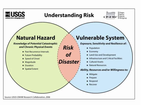
documented below, along with the findings of the risk assessment, should be used as the local level rationale for the risk reduction actions identified in Section 4 – Mission, Goals, and Action Items. The identification of actions that reduce a community’s sensitivity and increase its resilience assist in reducing the community’s overall risk, or the area of overlap in Figure 2.1 below.
Sensitivity and resilience factors specific to the cities of Burns and Hines and the Harney Electric Cooperative can be found in the city addendums located at the end of this plan.
Figure 2.1 Understanding Risk
Community Sensitivity Factors
The following table documents the key community sensitivity factors in Harney County. The information presented below was gathered at the March 28, 2007 community asset identification meeting (see Appendix A: Planning and Public Process for a meeting agenda, notes, and participation list).
Population
Population segments located in Harney County that can be particularly vulnerable to natural hazards include the following:
•
Students, especially in rural school districts•
Assisted living residents located in Burns•
Elderly populations in rural areas far from medical facilities•
Rural populations that can be isolated in an emergency•
Ranchers and agricultural workers•
Tourists: hunters, birders, and visitors to Steens Mountain•
Disabled populations that are homebound and located in rural areas•
Young families•
Native American populations, the Paiute Indians•
Spanish-speaking populations•
Incarcerated population•
Newcomers to Harney County that may not realize some of the dangers of living in the high desert.•
Mobile homes located in the floodplain in and around Burns/Hines.•
Population areas are growing into wildland/urban interface, with new housing developments growing in wild sagebrush area northwest of town•
The Meadowlands Ranch subdivision in the county is being built in the 100-year floodplain. The flood risk is uncertain because of the outdated flood maps for the county.Economic Assets
•
Major employers in Harney County are government agencies such as the Bureau of Land Management and the US Forest Service•
Local governments of Burns, Hines, and the county also provide employment•
The School system is a major employer, but the buildings are vulnerable to earthquakes.•
Agriculture is a major employer with hay and cattle ranching being the major products. Harney County has approximately 114,000 cattle in the whole county.•
Small businesses such as hotels depend on tourists who come to see the Malheur National Wildlife Refuge•
Two bulk plants in Burns and Hines for fuel storage•
Historic resources that benefit the economy are the Frenchglen Hotel, the Diamond Hotel, and the Round Barn.•
Infrastructure, especially the state highways (20, 395, 205, 78) are important to sustaining the local economy•
The hospital is an important economic asset to the community•
Wildlife in Harney County brings tourists, bird watchers and hunters.Cultural and Historic Assets
•
Unique historic structures in Harney County include the following:•
Peter French Round barn•
Frenchglen Hotel•
Diamond Hotel• All three buildings are subject to flooding, fire, and wind damage.
• All three buildings serve as economic assets, attracting tourists, but some also provide essential services to tourists such as hotel services
• Buildings or structures in Harney County listed on the National Register of Historic Places include the following:
• Allison Ranger Station
• Double-O Ranch Historic District
• Pete French Round Barn
• Frenchglen Hotel
• P Ranch
• Riddle Ranch
• Sod House Ranch
• Paiute Indian Tribes represent a cultural and historic asset to the community, some of their resources include seasonal camps, trails, and European and American homesteads located throughout the county, mostly in Forest Service and BLM lands.
• Fire lookouts in Forest Service and BLM lands provide unique cultural and historic structures representing wildfire history
• Structures relating to the timber and ranching industry are unique historical assets.
• Harney County Museum in Burns contains a collection of historical artifacts
• Other structures considered historical assets in Harney County include:
• Civilian Conservation Corps structures
• The Hines Park
• Old Hines Guesthouse
• The Hospital
• Military sites representing significant military battle sites Critical Facilities & Infrastructure
Critical facilities and infrastructure in Harney County include:
• The State highways, (395, 20, 78, 205)
• County roads
• Police, fire, and other emergency services
• Communications centers, especially the 911 call centers
• Communications infrastructure
• Cell phone towers
• Telephone lines
• Utilities
• Television and Cable
• Burns Municipal Airport which is located in the floodplain
• The Harney District Hospital and EMS.
• Water storage and treatment plans, both located in floodplains
• Oregon National Guard facility
• Government buildings
• County Courthouse
• City halls of Burns and Hines
• Jails-Youth Facility
• Schools
• Burns High School
• Hines Middle School
• Slater Grade School
• Interagency type 3 team, also known as the high desert type 3 team to respond to wildfires
• Fireguard stations in Frenchglen and Burns and Hines
• Areas important because to respond to a hazard event successfully, these areas must be protected
• Waste disposal facilities
• Fuel storage facilities
• Fairgrounds, also located in the floodplain
• Several areas in Harney County, especially in rural areas are one road in and one road out, and these areas are particularly vulnerable.
Natural Resources
Major Natural resources in Harney County include:
• Malheur National Wildlife Refuge
• Major tourist attraction for Harney County that could impact the county economically if the area is impacted by natural hazards
• Steens Mountain
• Major tourist attraction for Harney, and a vulnerable area for severe weather events for tourists visiting the mountain.
• Grazing allotments on Federal land (4 million acres), and many ranchers depend on these allotments to feed their livestock.
• Should grass and grazing be compromised due to natural hazards, then many ranchers could suffer losses or incur additional expenses to feed livestock.
• Impoundments
• Chickahominy reservoir
• Allison Spring
• Hot springs throughout Harney County
• Wildlife-Hunting, tourism
• Native hay meadows, important to keep them intact
• Forests
• Malheur National Forest
• Ochoco National Forest
• Park systems, golf course
• Geologic stability
• Mineral deposits
• Water resources
• Natural energy resources
• Solar
• Wind
Land Use and Development
• Isolated county parcels a problem in Harney County due to limited access to roads and services such as power and water
• Little regulation of buildings being built in the floodplain, there are building codes and restrictions that must be met, but no restrictions on where a building can be placed and what standards they can implement.
• Growth occurring in the northwest corner of Burns and Hines in the hills
• Meadow Land Ranch subdivision just east of Burns and Hines is another growth area
• This area is subject to flooding events, and new development, especially the construction of driveways, is restricting natural water flow in the low-lying area.
• Septic tanks are a problem in the county especially during flooding events.
• The floodplain map is very outdated and does not reflect existing flooding standards.
Community Resilience Factors
The following documents the key community resilience factors in Harney County including a description of the local government’s structure, existing plans and policies, and community organizations and programs.
Government Structure
Harney County’s governing jurisdiction includes all areas not governed by the US Forest Service, the Bureau of Land Management, the Paiute Indian reservation, the Malheur National Wildlife Refuge, and the incorporated communities of Burns and Hines.
The Harney County Court is the governing body responsible for administering Harney County ordinances and regulations. The court is comprised of three elected officials: the County Judge who presides over the court and two county commissioners. The court and commissioners are responsible for creating and presiding over regulations in the county.
The Harney County government also includes a number of different departments responsible for implementing county regulations.
The Planning department implements the Harney County Comprehensive Plan, the Harney County Zoning Ordinance, and the Harney County Subdivision Ordinance. The department is also responsible for processing county land use applications. The county zoning ordinance includes regulations for development in natural hazard areas, such as floodplains, steep slopes, and areas subject to wildfire. The county is also responsible for issuing a Floodplain Development Permit that provides documentation showing a structure is constructed at a particular height above grade to mitigate against future flood damage.2
1
Harney County contracts building inspections and permitting to a private business, Inspections, Inc., in place of having a county building department. Inspections, Inc. is responsible for conducting inspections on buildings in the county and issuing building permits, which are given final approval by the county. In addition, Inspections, Inc. is responsible for ensuring that buildings meet building code requirements in terms of requirements in floodplains.
Existing Plans & Policies
Communities often have existing plans and policies that guide and influence land use, land development, and population growth. Such existing plans and policies can include comprehensive plans, zoning ordinances, and technical reports or studies. Plans and policies already in existence have support from local residents, businesses and policy makers. Many land-use, comprehensive, and strategic plans get updated regularly, and can adapt easily to changing conditions and needs.2 The Natural Hazards Mitigation Plan includes a range of recommended action items that, when implemented, will reduce the county’s vulnerability to natural hazards. Many of these recommendations are consistent with the goals and objectives of the county’s existing plans and policies. Linking existing plans and policies to the Natural Hazards Mitigation Plan helps identify what resources already exist that can be used to implement the action items identified in the Plan. Implementing the natural hazards mitigation plan’s action items through existing plans and policies increases their likelihood of being supported and getting updated, and maximizes the county’s resources.
The following are existing plans and policies already in place within the community:
• Harney County Comprehensive Plan (2002)
• Harney County Zoning Ordinance-August (2002)
• Harney County Subdivision and Partitioning Ordinance
• Harney County Transportation System Plan (June 2001)
• Harney County Community Wildfire Protection Plan (December 2005)
• Harney County Emergency Operations Plan
Table 2.1 below further defines each of these plans and policies.
2
Burby, Raymond J., ed. 1998. Cooperating with Nature: Confronting Natural Hazards with Land-Use Planning for Sustainable Communities.
Table 2.1 Harney County Existing Plans and Policies
Plan Policy
and Name
Author
Purpose
Relation to Natural
Hazard Mitigation
Harney County Comprehensive Plan Harney County Planning Department Morgan, Ryan, and Associates“The Harney County Comprehensive Plan was developed for the purpose of providing a guide
for the conservation of Harney County’s land resources. It is a generalized long-range policy guide
and decision-making tool, which will affect economic, social and physical development of Harney
County.
The “Natural Hazards-Limitations” discusses among other things, floodplains, steep slopes, and earthquake hazards in
addition to a Natural Hazards and Limitation Policies.
Harney County Zoning Ordinance Harney County Planning Department
There are several purposes including: “to serve with the subdivision ordinance as the primary implementation tool for the
Harney County Comprehensive Plan, to encourage the most appropriate use and development of
land.”
Some zoning regulations may relate to natural hazards in the area, and it helps facilitate
implementation of the comprehensive plan, which
relates to natural hazards.
Harney County Subdivision and Partitioning Ordinance Harney County Planning Department
The subdivision ordinance is created for several reasons,
including: “to aid in the implementation of the Comprehensive Plan…to assist in the implementation of the Oregon Statewide Land use Goals and
Guidelines
Some of the building/lot regulations may be related to
natural hazard mitigation.
Harney County Transportation System Plan Harney County Planning Department
To provide and encourage a safe, convenient, and economic
transportation system.
Maintaining a well-functioning transportation system is necessary for the evacuation, response, and recovery periods
of the disaster cycle.
Harney County Community Wildfire Protection Plan Walsh Environmental Scientists and Engineers
The Community Wildfire Protection Plan (CWPP) “allows a
community to evaluate its current situation with regards to wildfire risk for protection of human welfare
and other important economic or ecological values.”
The CWPP assesses Harney County’s vulnerability to wildfires and provides a list of mitigation and response actions communities can take to reduce
that risk. Harney County Emergency Operations Plan Harney County Health Department
To provide a plan for responding to emergencies.
The Operations Plan outlines how organizations in the County
respond to emergencies. Organizations involved in response planning can coordinate