33 IGC excursion No 38*
Proterozoic igneous and metamorphic
rocks: a template for Mesozoic-Cenozoic
brittle faulting and tectonic inherited
landscapes in Lofoten-Vesterålen,
North Norway
Organizers:Steffen G. Bergh and Geoff Corner, Dept. of Geology, University of Tromsø Fernando Corfu, Dept. of Geosciences, University of Oslo, Norway
TABLE OF CONTENTS
Abstract... 3
Logistics... 3
Dates and location ... 3
Travel arrangements ... 3
Accommodation ... 3
Field logistics ... 3
General Introduction ... 4
Regional Geology ... 4
The Precambrian-Caledonian basement geology ... 4
The Lofoten-Vesterålen passive continental margin: a multiphase Mesozoic-Palaeogene rifted shelf... 10
The relationship between tectonics and landscape in the Lofoten-Vesterålen archipelago... 19
Excursion Route and Road Log ... 24
Excursion Stops ... 25 Day 1 ... 25 Day 2 ... 25 Day 3 ... 37 Day 4 ... 47 Day 5 ... 57 References... 64
Abstract
The Lofoten-Vesterålen archipelago of Northern Norway comprises a suite of a suite of anorthosite, mangerite, charnockite and granite (1870-1790 Ma) intruded within an
Archaean/Palaeoproterozoic high-grade metamorphic complex of ortho- and paragneisses that was part of the Fennoscandian shield. A few overlying pieces of Caledonian thrust nappes and local eclogites and pegmatites are the only products of the Caledonian orogeny in these
islands. In the Palaeozoic through Mesozoic, the Lofoten-Vesterålen region became part of the North Atlantic passive continental margin that underwent multiphase rifting and complex extensional brittle faulting prior to opening and oceanic-crust formation in the Early
Cenozoic. As a consequence of these events the Lofoten ridge became an exhumed and tilted basement horst surrounded by major offshore basins and bounding fault-fractures. The present day macroscale, valley- and ridge landscapes of Lofoten, to some extent, reflect Palaeozoic-Mesozoic passive margin fault patterns. Glacial erosion during the Quaternary has
subsequently created a fretted, alpine relief of glacial troughs, cirques and ridges which largely follow fracture systems.
Logistics
Dates and location
Timing: 14.08 - 18.08
Start location: Gardermoen Airport, Departure Terminal (place where participants are being picked up and from where costs included in the pre paid fee start to apply).
End location
:
Gardermoen Airport (place where excursion ends and from which participants continue with their own travel arrangements).Travel arrangements
The participants will be picked up at the airport by one of the excursion leaders, Fernando Corfu. The best way to reach Gardermoen is to use the main train shuttle (flytoget) departing from the Oslo Central Station (Oslo S). Present price is NOK 170 one way. Alternative travel is by bus (c. NOK 140-180) or taxi (c. NOK 500).
Accommodation
Accommodation in Lofoten will be arranged in chalets and seaside guest houses (rorbuer), mostly in shared bed rooms but a few single rooms are also available. The standard is generally high, and all of the chalets have electric heating (adapter needed for
non-Scandinavians), fully equipped rooms, kitchen, dining room, TV, bathroom with shower, w.c., etc. Each bed is inclusive of linen and towels. The overnight schedule is as follows: 14-16/8 Nusfjord Rorbuanlegg AS, Phone 76093020, 16-17/8 Henningsvær Rorbuer, 17-18/8
Sjøhussenteret, Sortland, Phone: 76123749. A number of other accommodation facilities are available in Lofoten (see http://www.lofoten-startside.no/overnatting.htm).
Field logistics
The transportation will be by bus to all the localities. Only a few of the localities require some hiking, with a maximum of 2 km in easy terrain on paths. Most of the stops will be near the main road or along easily accessible coastal/shoreline sections. The weather in mid August is generally mild with average temperature c. 15°C. Occasionally during the summer, westerly
winds from the Atlantic may bring lots of rain and quite cold weather. Therefore, be prepared both for sunny and wet weather and bring with you warm clothes, raingear, and good field boots.
General Introduction
The excursion through the Lofoten-Vesterålen archipelago has a threefold purpose as it will examine: (i) the Precambrian-Caledonian basement geology, (ii) the development of post-Palaeozoic/Mesozoic structures related to the opening of the North Atlantic, and (iii) the relationship between tectonics and landscape. The dominant bedrock is made up of a Palaeoproterozoic (1870-1790 Ma) igneous complex of mangerites, charnockites,
anorthosites, gabbros and granites, intruded within an Archaean-Palaeoproterozoic high-grade metamorphic complex. At Leknes, and to the east, the Lofoten basement is overlain by
Caledonian thrust nappes in a similar setting as the Western Gneiss region of Southern Norway, except that the Caledonian overprint was much weaker in Lofoten. This allows insightful studies of arc-related magmatic rocks and tectonometamorphic processes operating at lower crustal levels. Brittle faults and fractures formed during Mesozoic-Cenozoic break-up of the North Atlantic continental margin can be excellently studied in a transect along the Lofoten ridge to Vesterålen. This ridge is an exhumed and tilted basement horse near the continent-ocean margin and is surrounded by major offshore basins such as the Vestfjorden and Ribban basins. A complex system of multiphase fault-fractures bounding these basins can be studied on the onshore side of the horst, allowing a direct comparison between the offshore and onshore regions. This excursion will also explore pronounced valley- and ridge
landscapes resembling tilted fault blocks, and a system of gently-dipping paleosurfaces bounded by steep fault-related escarpments. This high-relief landscape is thought to reflect Cenozoic exhumation of the tilted Palaeozoic-Mesozoic fault blocks.
Regional Geology
The following description of the regional geology is divided into three parts according to the thematic goals of the excursion: 1) The Precambrian-Caledonian basement geology, 2) the Lofoten-Vesterålen passive continental margin: a multiphase Mesozoic-Palaeogene rifted shelf, and 3) the relationship between tectonics and landscape.
The Precambrian-Caledonian basement geology
The Lofoten-Vesterålen islands are underlain by Precambrian basement, which emerges west of the allochthonous nappes occupying the central, NNE-trending axis of the Scandinavian Caledonides (Fig. 1). This basement high stretches to the north into the Western Troms area. In spite of this internal position the rocks of Lofoten-Vesterålen display only subordinate evidence of Caledonian deformation (Griffin et al. 1978). The basement is composed mainly of a metamorphic complex of Archean and Palaeoproterozoic para- and orthogneisses, intruded by a very extensive suite of plutonic rocks of the anorthosite-mangerite-charnockite-granite (AMCG) suite (Fig. 2). The area is a part of the Svecofennian orogen and lies
approximately along the southern boundary of the Archean craton that stretches from Russia, through Finland and Sweden. A Palaeozoic succession overlies the basement at Leknes, probably remains of a Caledonian nappe.
Fig. 1: Regional onshore-offshore geological map of Central/North Norway and the outline of the North Atlantic passive continental margin (after Mosar et al. 2002). The
Lofoten-Vesterålen archipelago is framed.
The Lofoten-Vesterålen rocks were shown to be of Precambrian age by Herr et al. (1967) and Heier and Compston (1969), the latter documenting major events at 2800 and 1800 Ma. Subsequent work based primarily on Pb-Pb and Rb-Sr, and eventually Sm-Nd dating, broadly confirmed the two-stage evolution, expanding it to include older events and introducing a number of other apparent sub-stages (Taylor 1974, 1975; Griffin et al. 1974, 1978; Jacobsen & Wasserburg 1978; Andresen & Tull 1983; Wade 1985). There were also some indications of a cryptic event at about 1100 Ma and of a weak overprint during the Caledonian orogeny. Recent work does not substantiate the indications for a Grenvillian overprint, instead
documenting a more complex Caledonian history, characterized by several separate stages between the Ordovician and the Permian (Corfu 2004b; Hames & Andresen 1996; Steltenpohl et al. 2004, 2006). The chronology of the basement complex and the AMCG suite has been refined by modern U-Pb geochronology (Corfu 2004a, b, 2007); the results are summarized below while presenting the main rock units.
The basement complex and the timing of metamorphism
The basement complex in western parts of Lofoten-Vesterålen comprises granulite facies rocks, whose distribution also coincides with a major magnetic and gravity high due to the
presence of dense rocks in the crust and an elevated Moho discontinuity (Heier 1960; Griffin et al. 1978; Mjelde et al. 1993; Olesen et al. 1997). The latter is the result of differential uplift and extension in the aftermath of the Caledonian orogeny and the subsequent Late Palaeozoic and Mesozoic processes that led to the opening of the North Atlantic. The eastern part of the region consists instead of various amphibolite-facies gneisses, migmatites, greenstone belts and granitic plutons.
Fig. 2: Geological map of the Lofoten-Vesterålen islands showing the Archaean-Palaeoproterozoic basement and intruding plutonic suite (modified from Tveten 1978, Andresen & Tull 1983 and Corfu 2004a).
Archaean crust occupies large parts of the islands of Langøy and Hinnøy (Fig. 2). Small remnants are also present at the southwestern tip of Austvågøy (Wade 1985). A younger sequence of metasedimentary rocks is dominated by fine-grained gneisses, locally quartzitic, with subordinate graphite schist, iron formation and marble. Although they have been overprinted by the same granulite-facies metamorphism as the Archaean rocks the paragneisses are of more homogeneous appearance and have been interpreted as a Palaeoproterozoic supracrustal succession of volcanogenic derivation as deduced from geochemical compositions (Griffin et al. 1978). The boundary between the two metamorphic domains corresponds to the eastern limit of the magnetic high. It was defined initially by Heier (1960) who mapped the first appearance of orthopyroxene along a line running south to southwest in eastern Langøy (Fig. 2). In the south he linked the line to a local thrust that juxtaposes the Eidsfjord anorthosite on retrogressed mangerite (Heier 1960; Markl 1998), but subsequent studies modified the trajectory, suggesting that the orthopyroxene isograd is folded and continues southeastward across Hinnøy (Fig. 2; Griffin et al. 1978). Glassley (1975) investigated carbonate bodies in the region and defined isograds for the reactions
hornblende = diopside + spinel and diopside + dolomite = forsterite + calcite. In northeastern Langøy these two isograds deviate considerably from the orthopyroxene isograd, a fact interpreted by Glassley (1975) to indicate a complex thermal structure of the crust. The granulite facies gneisses equilibrated at 3 to 4 kbar and 750 to 780 °C (Olsen 1978). These rocks tend to be rather massive, with faint banding visible in weathered outcrop but hardly recognizable in fresh cuts. They have been considered to be orthogneisses (Taylor 1974) or migmatized supracrustal rocks of intermediate composition (Griffin et al. 1978). Mafic enclaves occur locally.
The nature of the amphibolite to granulite facies transition has been the subject of debate. In the early literature it has been customary to consider the transition as the result of one single metamorphic event. On the basis of Rb-Sr whole-rock data of metamorphosed supracrustal rocks this event was estimated at 1830 ±35 Ma (Griffin et al. 1978). The dominant
interpretation has been that of a metamorphic progression with westward increasing
temperature and pressure. The possibility of a retrograde transition has also been considered but found to be inconsistent with the known evidence (Olsen 1978). The third alternative is that the transition is a tectonic boundary (Corfu, 2004b, 2007). Recent U-Pb data confirm the general understanding of the Lofoten-Vesterålen crustal history (Heier & Compston 1969; Griffin et al. 1978) providing additional evidence for two major periods of crust accretion and stabilization in the late Archean and the Late Palaeoproterozoic. Archean U-Pb ages are found in zircon and monazite both in the high- and the medium-grade parts of the region and define distinct events. The available data indicate magmatism in the period between about 2750-2680 Ma with a subsequent event at about 2640 Ma involving the emplacement of tonalite and high-grade metamorphism including migmatization, thus, adding new magmas and reworking existing crust. The original crust had formed during a major crustal accretion event recorded at 2850-2700 Ma throughout the region (Corfu et al. 2003; Kullerud et al. 2006). The new data are consistent with the existing Pb, Sr and Nd isotopic constraints (Jacobsen & Wasserburg 1978; Wade 1985).
The Proterozoic metamorphic history falls broadly in the time frame between the AMCG precursor-stage (Hopen pluton) at about 1870 Ma and the main AMCG stage at 1800-1790 Ma (see below). The data indicate high-grade metamorphism 5 to 10 million years before emplacement of the main AMCG stage, with a less clearly defined metamorphic event
broadly coeval with the AMCG precursor stage. A third group of metamorphic ages coincides with the main stage of AMCG magmatism. There is then a late phase of retrogressive
metamorphism between 1780 and 1760 Ma (Corfu 2004a, 2007).
The documentation of a complex polymetamorphic evolution raises questions on the nature of the metamorphic boundary. The validity of the postulated Proterozoic prograde
metamorphism (Olsen 1978) rests on the achievement of complete mineralogical re-equilibration during the main-AMCG stage at 1800-1790 Ma, which is not a very safe assumption. At least in some cases, the boundary separates unrelated amphibolite and granulite facies terrains, e.g., at Sigerfjord a 2640 Ma migmatite complex from 1800 Ma granulites. These relationships are more consistent with a tectonic boundary. On the other hand, however, one has to consider the close age correspondence of events in both terrains, i.e. events at 2640, 1870 and 1800 Ma, which suggests that the two terrains were in close proximity prior to formation of a tectonic contact, thus supporting the traditional view (e.g., Griffin et al. 1978).
Plutonic rocks
Plutons of the AMCG suite occupy about 50 % of the islands (Malm & Ormaasen 1978). The suite is dominated by mangerite and charnockite and their retrograded equivalents, with local but important occurrences of gabbro, anorthosite and granite. The mafic and felsic phases locally grade into, or mutually cross-cut, each other indicating that some of the intrusions may be genetically related. Markl (2001) proposed a multistage evolution with a basaltic parental melt undergoing polybaric crystallization and differentiation to form anorthosites as
cumulates and ferrodiorites and jotunites as residual melts. The mangerites and charnockites are inferred to represent feldspar cumulates and residual liquids, respectively, derived from magmas broadly syenitic in composition, which may or may not be directly related to the ferrodiorites. The mangerites and charnockites were shown to have intruded at about 4 kbar and >925 to 850 °C whereas the anorthosite on Flakstadøy records a polybaric crystallization history from 9 kbar to about 4 kbar at 1180 to 1120 °C. The data imply that anorthosites, mangerites and charnockites in Lofoten were emplaced at the same depth of about 12 km (Markl et al. 1998).
Isotopic data show that Archaean crust played an important role in the genesis of these rocks, both as a source and as a contaminant (Wade 1985; Markl & Höhndorf 2003). The Pb isotopic data define a linear trend, interpreted to represent mixing between Archaean lower crustal components and late Palaeoproterozoic juvenile additions, whereby the mangerites and charnockites contain more Archaean Pb than the mafic rocks. Most anorthosites, ferrodiorites and the felsic rocks yield overlapping εNd values ranging from -3 to -9. Exceptions yielding more primitive εNd - values between -1 and +1 are ferrodiorite to gabbro from the Eidsfjord Complex (Markl & Höhndorf 2003) and mangerite from northern domains of Austvågøy and Flakstadøy (Wade 1985). The distribution of Sr isotopic compositions broadly matches that obtained from Nd.
Charnockites and mangerites are widespread throughout the region, especially in the form of large plutons such as the Raftsund, Hopen, Sund-Ølkona and Southwest Lofoten intrusions (Griffin et al. 1974; Ormaasen, 1977; Malm & Ormaasen 1978). Anorthosite occurs at three different sites: on Moskenesøy, Flakstadøy and at Eidsfjord. Gabbro forms smaller plutons in all the islands, the largest one is the Eidet-Hovden pluton on Langøy (Heier 1960; Romey 1971; Markl 1998; Markl et al. 1998; Markl & Frost 1999). There is one distinctive body of granite-syenite, the Torset pluton on Langøy (Heier 1960; Brueckner 1971). In addition, a widespread and diffuse network of feldspathic veins is present throughout the granulite facies domain, especially on Langøy, and it is difficult to distinguish this late veining from the original migmatitic structures described by Griffin et al. (1978).
The more recent U-Pb results show that the Lofoten AMCG suite was emplaced during two quite distinct events (Fig. 3), the first one at 1870-1860 Ma (Hopen pluton and Blokken orthogneiss) followed by a second and dominant magmatic event at 1800-1790 Ma. A concluding period, lasting some 20-30 m.y., was characterized by local hydration of the dry AMCG rocks, and by the infiltration of pegmatitic melts (Corfu 2004a). Local granitic pegmatites belong to distinct generations, one Palaeoproterozoic (ca. 1770 Ma) and the other Caledonian (Corfu 2004a, b, 2007).
The zone east of the metamorphic boundary is dominated by intrusive rocks of tonalitic to granitic composition, migmatitic domains, and local greenstone belt remnants. Preliminary data indicate an Archean origin for the basement units (Taylor 1974; Griffin et al. 1978; Corfu
unpubl. data). They are cut by Palaeoproterozoic plutons such as the Lødingen granite with a zircon and titanite age of 1870 Ma (Corfu 2004a). The Tysford granite covers a large area on the mainland (Andresen & Tull 1986) and has given U-Pb ages between 1800 and 1700 Ma (Romer et al. 1992).
Fig. 3: Summary of U-Pb ages for the Archaean and Palaeoproterozoic magmatic and metamorphic rocks of Lofoten Vesterålen, with a comparison to the general scheme for the tectonic evolution of the Svecofennian orogen (from Corfu 2004a, 2007).
Regional correlations
The 1870-1860 Ma phase of magmatism, marked by the emplacement of one mangeritic-charnockitic pluton and a granite body, was coeval with the main collisional and arc
amalgamation event in the Svecofennian orogen. The second and dominant period of magmatism in Lofoten-Vesterålen at 1800-1790 Ma coincides with the emplacement, throughout the Svecofennian orogen, of widespread and compositionally variable plutonic associations of both mantle and crustal origin and also corresponded to a shift in convergence rates, possibly related to more distant continental collision. It appears that the AMCG suite was formed as a consequence of these major tectonic events. Geometric and kinematic factors such as the position of the area at the margin of the Archaean craton, the changing plate kinematics may have been the most important variables that led to the development of this unique rock association in Lofoten-Vesterålen.
The region also underwent a Caledonian high-pressure event, although that is only locally recorded (Wade 1985; Markl & Bucher 1997; Kullerud et al. 2001; Steltenpohl et al. 2006). Eclogite-facies rocks with relics of omphacite in addition to garnet as main minerals occur at five localities on two islands (Flakstadøy, Austvågøy). At five additional localities on
Flakstadøy and Vestvågøy, mineral textures and field aspects of garnet amphibolite bodies suggest that they represent retrogressed eclogites. Most of the eclogites occur within gabbros, on Flakstadøy also in troctolites. With two exceptions they are always related to zones of deformation, occurring in lenses of 2 m to 70 m in length. The peak eclogite assemblage is garnet + omphacite + magnetite + rutile but most occurrences are retrogressed. High-pressure parageneses have also been documented in pseudotachylites (Stelthenpohl et al. 2006). Based on original Rb-Sr data, Markl & Bucher (1997) had concluded that the eclogite facies event was probably related to Mesoproterozoic orogenic activity, but this inference has not been confirmed by more recent data. Although there is no firm direct age for this event, all the circumstantial evidence point to a Caledonian origin (Steltenpohl et al. 2006).
Leknes Group
On Vestvågøy the basement is overlain by the Leknes group, a distinct assemblage of amphibolite-grade paragneisses and schists in tectonic contact with the Palaeoproterozoic basement, and which was multiply deformed and metamorphosed during the Caledonian orogeny (Tull 1977; Corfu 2004b). The metasedimentary assemblage was intruded by
tonalitic dykes at 469 ±3 Ma. Such dykes are absent in the underlying basement supporting an allochthonous origin of the Leknes Group. Structural and U-Pb radiomentric evidence shows that the main metamorphic and structural overprints occurred in the Mid-Ordovician, between 470 and 460 Ma, but there was also a younger metamorphic event with zircon growth at 412 ±2 Ma, the latter coinciding with early stages of extension and enhanced fluid activity; in southern Lofoten this episode is also associated with the intrusion of 410 ±3 Ma pegmatites. The Leknes Group shows an affinity with some terranes of peri-Baltican affinity in the Upper Allochthon of the Caledonides. It probably developed in a marginal basin close to
Sveconorwegian basement, before being thrust onto the Lofoten basement.
The Lofoten-Vesterålen passive continental margin: a multiphase Mesozoic-Palaeogene rifted shelf
The Lofoten-Vesterålen continental margin (Fig. 1) marks the transition between the much wider Møre-Vøring passive margin (Blystad et al. 1995; Brekke 2000) and the sheared,
1993). It is a key region for plate reconstruction and tectonic linkage of the Norwegian-Greenland Sea margins as well as for onshore-offshore structural comparison. The shelf comprises a narrow and thin crustal segment underlain by a Permian through Palaeogene clastic sedimentary wedge and bounded seaward by Palaeocene to Eocene ocean-floor volcanites (Eldholm et al. 1979; Sellevoll et al. 1988; Mjelde et al. 1993).
Fig. 4: (a) Depth-converted structural contour map of the top-basement reflection and interpreted major faults for the offshore shelf areas (Bergh et al. 2007). Note location of the seismic sections outlined in Fig. 7. (b) Interpreted cross-section (lines L086R90-04 and
L087R00-08) across the shelf margin from the Røst High to east of the Vestfjorden Basin. See Fig. 7 for legend to the cross-section. Abbreviations are: TB = Top-Basement, BC = Base-Cretaceous, APT = Intra-Aptian, IC = Intra-Cenomanian, BT = Base-Tertiary, HF =
Hamarøya Fault, ELBF = East Lofoten Border Fault, VFZ = Vesterdjupet Fault Zone, WLBF = West Lofoten Border Fault.
The Lofoten shelf is structurally complex and made up of shelf-parallel basement ridges and shallow-seated, mainly Cretaceous basins bounded by complex extensional fault systems with variable orientations (Mokhtari & Pegrum 1992; Blystad et al. 1995; Løseth & Tveten 1996; Olesen et al. 1997; Tsikalas et al. 2001, 2005). The main basement high is the Utrøst Ridge (plus the Røst and Jenegga Highs), which is parallel to the Lofoten Ridge (Figs. 1 and 4). Major basins include the Røst Basin on the seaward side of the shelf, the Ribban Basin
(including Skomvær and Havbåen sub-basins) on the central part of the shelf, the Træna Basin EL BF (?) a metres Ham arøy a Faul t Værøy Røst And-fjorden b
to the southwest and the Vestfjorden Basin on the landward side (Mokhtari & Pegrum 1992; Blystad et al. 1995; Løseth & Tveten 1996). Major faults include the West Lofoten and East Lofoten Border faults bounding the Lofoten Ridge, the Hamarøya Fault (Olesen et al. 2002) on the landward side of the Vestfjorden Basin, and the Vesterdjupet Fault Zone bounding the eastern flank of the Træna Basin (Fig. 4). These intra-crustal basins are all bounded by normal faults and filled with predominantly Lower to Upper Cretaceous sedimentary rocks that are locally almost 7 km thick. Pre-Cretaceous (Permo-Jurassic) sedimentary strata are recognized in the Træna Basin, Havbåen Sub-basin and the Vestfjorden Basin (Blystad et al. 1995). Late Cretaceous through Early Cenozoic strata overly these faulted basin successions and lap onto the basement highs. To the south of Lofoten, the shelf margin widens at the transition to the Møre-Vøring margin by gradual diminishing of the Skomvær Sub-basin and widening of the Træna Basin (Fig. 1). These Lofoten-line elements (Doré et al. 1997) are all parallel to the
Møre-Trøndelag Fault Complex (Blystad et al. 1995). North of Lofoten, the shelf is underlain by basins and is further linked to the transform plate margin of the Barents Sea along the NNW-SSE trending Senja-Fracture Zone (Gabrielsen et al. 1990). This transform is inferred to step onshore east of Andøya (Forslund 1988; Olesen et al. 1997). Jurassic and Lower Cretaceous sedimentary rocks also occur in localised basins onshore Andøya (e.g. Dalland 1981) and in near-shore basins adjacent to Sortlandsundet and Gavlfjorden (Fig. 5), as indicated by shallow-level seismic data (Davidsen et al. 2001; Fürsich & Thomsen 2005).
Fig. 5: Generalised bed rock geological map of Lofoten and Vesterålen including main foliation trends (modified after Tveten 1978) and interpreted traces of major and minor brittle lineaments (see more details in Fig. 8).
Offshore fault populations
Major faults cutting the basement-cover contact and those detaching in Jurassic-Cretaceous basin strata are outlined on the top-basement depth-converted structural map (Fig. 4). Two dominant fault trends are observable, (i) NNE-SSW striking, and (ii) NE-SW to E-W striking. The major faults bounding the Lofoten Ridge and Vestfjorden Basin display a left-stepping geometry, whereas the NNE-SSW striking fault sets typically are arranged oblique to and
Jurassic – Cretaceous rocks Caledonian nappes
Granitoid rocks (Palaeoproterozoic) Metasupracrustal rocks (Palaeoproterozoic) Magmatic-mangeritic rocks (Palaeoproterozoic) Gneisses and migmatites (Archaean and Palaeoproterozoic)
Faults and fractures (major) Faults and fractures (minor) Foliation LEGEND N Vesterålen Lofoten Sortland-sundet Gavl-fjorden 0 10 20 30 km
often in between the former (Fig. 4). An apparent curvature of the NNE-SSW faults into the NE-SW faults produces a zigzag or curved rhombic pattern. On a local scale, relay and horsetail geometric fault arrays exist. Some faults die out along strike and/or are replaced by the more NE-SW striking, regionally extensive faults. The map pattern also shows local anastomosing faults with breaching and rejoining of the two dominant fault groups, as seen adjacent to the Utrøst Ridge and Jenegga High. Bouguer gravity and aeromagnetic anomaly maps combined with 3D images constructed from 50 km high-pass filtered gravity data (Fig. 6) confirm the presence of step-wise, rectilinear NNE-SSW and NE-SW-trending lineaments near the basement ridges and surrounding basins (Åm 1970; Talwani & Eldholm 1972; Olesen et al. 1997; 2002; 2007). Also visible on the filtered magnetic data (Fig. 6) is a set of distinct NE-SW trending lineaments that truncate the entire margin from the Røst High in the southwest to Andøya in the northeast, corresponding to the offshore West Lofoten Border Fault and onshore trends bounding the Lofoten Ridge.
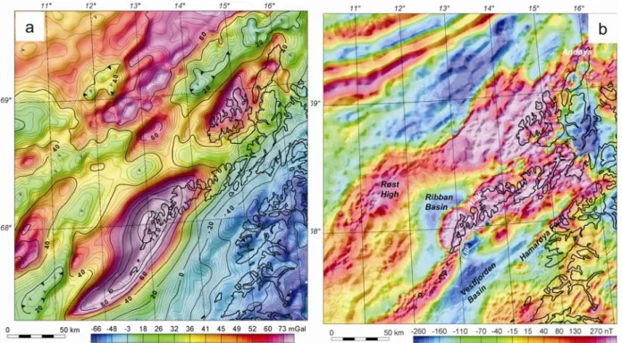
Fig. 6: (a) Residual gravity after isostatic correction of Bouguer gravity data from the
Lofoten-Vesterålen region (Olesen et al. 2007). The contour intervals are 2.5 mGal (thin lines) and 20 mGal (bold lines). A shaded relief version of the 100 km Gaussian high-pass filtered Bouguer gravity dataset is superimposed in colour on the gravity residual map. (b) Compilation of aeromagnetic surveys in the Lofoten-Vesterålen region (Olesen et al. 2007). The contour intervals are 25 nT (thin lines) and 100 nT (bold lines). A shaded relief version of the 20 km high-pass filtered aeromagnetic compilation is superimposed on the aeromagnetic residual map in colour. The 'illumination' of both shaded relief versions in (a) and (b) is from the southeast. Note the presence of rhombic shaped blocks bounded by stepped, rectilinear features and trends of magnetic basement that largely follow the major fault-bounded ridges and basins.
Fig. 7: NW-SE key seismic sections (a-e) from the Lofoten-Vesterålen shelf (Bergh et al. 2007). See figure 4 for location of the sections.
Three genetically related fault-fracture populations (Fig. 7) were identified on regional 2D seismic sections (Bergh et al. 2007). Population 1a defines ESE-dipping extensional normal detachments that bound the Træna Basin against the Røst High, the Havbåen Sub-basin against the Jenegga High, and the Vestfjorden Basin against the Lofoten Ridge. Their old age is supported by wedge-shaped pre-Cretaceous (Permo-Jurassic?) strata in the hanging-wall (Fig. 7a). An antithetic subset, termed population 1b faults dip consistently WNW and affected strata up to the base-Cretaceous level in the hanging wall, e.g. east of the Røst High/Utrøst Ridge, on the landward side of the Havbåen Sub-basin and in the Vestfjorden Basin (Fig. 7). Population 2 represents NW-dipping normal faults bounding the margins of main basins and the western Lofoten Ridge. This dominant fault population is represented by normal faults that bound NE-SW trending and repeatedly eastward-tilted blocks and half-grabens filled by thick, wedge-shaped Cretaceous strata east of the Træna and Ribban Basins. (3) Population 3 faults are the youngest set of NW-dipping normal faults that affected the Late Cretaceous to Palaeogene post-rift sedimentary wedge, e.g., west of the Røst High and on the outermost shelf of Andøya, at the continent-ocean transition. They break through the base-Tertiary reflection and obliquely truncate all other fault sets.
Onshore fault-fracture groups
Onshore brittle faults and fractures in Lofoten and Vesterålen are easily recognized on satellite and aerial photograph and 3D images (Fig. 8), and in field outcrops. Detailed structural analysis indicates the existence of three lineament sets striking: (i) NNE-SSW, (ii) ENE-WSW to E-W, and (iii) NW-SE, respectively (cf. Gabrielsen & Ramberg 1979;
Gabrielsen et al. 2002; Bergh et al. 2007). The first lineament set is arranged parallel to many narrow fjords and sounds in Lofoten, e.g. Tjeldsundet, Øksfjorden, Gullesfjorden, Raftsundet, Gimsøystraumen and Nappstraumen (Fig. 8). They all show a straight to parallel, locally right-stepping and relay geometry, where individual fault traces die out or breach along strike. Curved fault traces characterise the central and eastern Lofoten archipelago (Fig. 8). The second set is parallel to the main NE-SW to ENE-WSW trend of the Lofoten islands and Vestfjorden (Gabrielsen et al. 2002). It is marked by linear escarpments along the coastal cliffs to the north and south of Lofoten (e.g. Eggum and Henningsvær), linear valleys of the interior such as Olderfjorden on Vestvågøy, and the linear depression along Hadselfjorden and Ingelsfjorden (Fig. 8). In Vesterålen, these lineaments can be traced across Langøya to Andøya, where they bound the southern margin of a Jurassic-Cretaceous basin on land (Dalland 1981). Similar basins exist offshore in Gavlfjorden and Sortlandsundet (Fig. 5). In all these areas the basins are bounded by NNE-SSW (S1) and ENE-WSW (S2) striking faults producing zigzag-shaped basins. The third, NW-SE striking set is well displayed as rectilinear fault-fracture strands in the westernmost Lofoten islands and on Langøya (Fig. 8).
The relative timing of these lineament trends was established from critical observations in the field: (a) the NNE-SSW set is the most irregular-traced and is off-set and/or truncated by more linear ENE-WSW and E-W sets, (b) an apparent curvature of the NNE-SSW set into the ENE-WSW and E-W sets, and (c) the NW-SE-striking set in the west is rectilinear and
consistently truncates all other sets. The systematic cross-cutting relationships in the field throughout Lofoten (Eig et al. in prep.) suggest that the NNE-SSW set is the oldest (termed S1), the ENE-WSW and E-W sets are of intermediate age (termed S2), and the NW-SE set is the youngest (termed S3). This interpretation deviates from Wilson et al. (2005, 2006) who applied a uniform WNW-ESE extension vector for eastern Lofoten. In their model, various fault patterns were activated synchronously in segmented domains at different angles to the presumed regional extension.
Fig. 8: Summary of the main onshore lineaments in Lofoten-Vesterålen, interpreted from Landsat satellite images (Bergh et al. 2007). The different fault-fracture sets are grouped according to their geometric characteristics and relative timing (S1, S2 and S3).
Passive margin tectonic evolution
Plate reconstructions of the Norwegian-Greenland Sea and passive margins (Ziegler 1988, 1989; Lundin & Doré 1997; Doré et al.1999; Roberts et al. 1999; Mosar et al. 2002) and recent reviews of palaeomagnetic anomalies (Roest & Strivastava 1989; Torsvik et al. 2001a, b; Mosar et al. 2002; Olesen et al. 2007; Torsvik & Cocks 2005) suggest progressive E-W directed rifting from the Permo-Jurassic (250-150 Ma) to Early Cretaceous (100-90 Ma), followed by a more WNW-ESE to NW-SE opening trend in the Early/Late Cretaceous and Palaeogene, and ending with uniform NW-SE oceanic spreading in the Eocene.
Fig. 9: Regional offshore-onshore fault-fracture map of the Lofoten-Vesterålen margin (Bergh et al. 2007).Abbreviations: ELBF=East Lofoten border fault, HF= Hamarøya fault, SF=Sortlandsundet fault, VFZ=Vesterdjupet fault zone, WLBF=West Lofoten border fault. A three-phase passive margin fault evolution was proposed by Bergh et al. (2007) and
includes (Figs. 9 and 10): (1) Population 1a (S1 onshore) faults initiated in the Permo-Jurassic proto-rift phase where WNW-ESE orthogonal extension was pervasively distributed across weakly interacting, stepwise arrays of NNE-SSW-striking normal faults and basins. Local NNW-SSE oblique extension later in the Jurassic (?) generated antithetic faults offshore (population 1b) and probably reactivation onshore as well in transition zones between major S1 faults and basins. (2) A main, syn-rift stage of Early to Late Cretaceous basin-and-margin fault evolution was accomplished by a change to a NNW-SSE extension direction and oblique reactivation of population 1a-1b and S1 faults producing major ridge-basin bounding
extensional and dextral strike-slip faults (population 2 and S2 faults). (3) Continued regional NNW-SSE extension with local incremental rotation and NNE-directed shear stresses produced post-rift population 3 and S3 faults and fractures. All the established fault-fracture
sets may have been accomplished by further brittle reactivation in the Cenozoic. This multiphase fault evolution model requires a progressive clockwise rotation of the regional stress axis from c. E-W to NNW-SSE within the Mesozoic-Palaeogene intervals. In this context, earlier stepping normal faults (population 1a-1b and S1) and oblique basins and ridges may have acted as precursors to the subsequent transtensional faults (population 2-3 and S2-S3) and linked, margin-parallel basins.
Fig. 10: (a-d) Chronologic and kinematic evolution model for offshore (left) and onshore (right) fault populations and lineaments combined with fault-basin restoration, sediment deposition and palaeogeography (Brekke et al. 2001; Henriksen et al. 2003; Bergh et al. 2007; Statoil, unpublished data). Note the clockwise rotation of inferred strain field onshore used to explain the separate fault patterns.
The relationship between tectonics and landscape in the Lofoten-Vesterålen archipelago
The Mid/North Norwegian passive margin formed through several stages of rifting from the Late Palaeozoic to the Palaeogene (e.g. Dore et al. 1999). During the late-stage or post-rift uplift stages, the Fennoscandian margin underwent c. 2500 m uplift accompanied by
deposition of more than 4 km of sediments in adjacent offshore basins. New evidence shows that extensional faulting continued, as well, after the onset of seafloor spreading (Reston et al. 2004). This is well demonstrated in, e.g., the Lofoten-Vesterålen area, where Cenozoic uplift was accompanied by active faulting (Redfield et al. 2005). The cause(s) and consequences of this post-rift uplift (i.e. denudation age and geometry, drainage evolution, landscape formation and structural control) are still incompletely understood and lack a unifying framework.
New regional apatite fission-track (AFT) ages in Fennoscandia (Hendriks et al. 2004, 2007) have revealed a large-scale inverse relationship to the topographic elevation, indicating that the gross-scale topography resulted from `post-rift´ differential denudation (Redfield et al. 2005). For example, AFT age-jumps across tectonic lineaments in Lofoten and Vesterålen indicate that kilometer-scale faulting took place onshore later than c. 70-90 Ma (Fig. 11; Redfield et al. 2005), and controlled formation of prominent geomorphic lineaments and eastwards back-tilt of high-level palaeosurfaces (Bergh et al. 2006, Lidmar-Bergström et al. 2007, Osmundsen et al. 2007a). Thus, faulting appears to have continued to play an important role in the creation of the Cenozoic landscape. Movements along some of these faults may have continued to present day (Osmundsen et al. 2008).
Fig. 11: Apatite-fission track ages for the Lofoten-Vesterålen region (Redfield et al. 2005). In the Lofoten-Vesterålen archipelago and adjacent offshore passive continental margin the multiphase pre/syn-rift extension and post-rift crustal rejuvenation during the Mesozoic and Cenozoic resulted in a system of basins and ridges bounded by major extensional and oblique-normal faults (S1 to S3; Bergh et al. 2007) with step-wise to zigzag geometries and variable orientations and dip polarities (Fig. 9). These faults were superimposed on steep ductile fabrics in the crystalline basement rocks trending variably N-S and NW-SE.
Fig. 12: Conceptual model indicating relationships between displacement gradient along a normal fault and resultant topography, AFT age-pattern and fluvial drainage pattern (Redfield et al. 2005). PAZ=palaeo-zone
A model of structural controls on denudation, uplift and landscape evolution by Cenozoic fault re-activation is currently being tested in Lofoten, where truncation, offset and rotation of geomorphic surfaces have been proposed (Fig. 12), and where jumps in AFT ages are
apparent (Bergh et al. 2006, 2007, Hendriks et al. 2007). Fault displacement probably had a profound control on the spatial and temporal evolution of drainage basins and on the tilting of palaeosurfaces, at least on the local scale (Redfield et al. 2005). The age of tilted surface(s) in Lofoten-Vesterålen is unknown, but this local, high-relief landscape likely reflects
pre-Quaternary geomorphological features, e.g. Cenozoic exhumation of tilted
Palaeozoic-Mesozoic fault blocks and paleosurfaces bounded by extensional faults of the type recognized in offshore seismic data (Fig. 13: Bergh et al. 2007). Alternatively, the faults cut and rotate surfaces similar in age to the Paleic surface of southern Norway. The palaeic surface (Reusch
1901) is a term that refers to the elevated ‘old’ land surface that stands in marked contrast to ‘young’ landforms incised into it, such as cirques, deep valleys and coastal cliffs. It is
generally assumed to have been uplifted prior to the Quaternary, but its morphology, age and mode of formation is not well constrained (Japsen & 2000; Corner 2005b). Whereas Ahlman (1919) and Gjessing (1967) argued that the Paleic surface consists of one surface generation formed by deep weathering processes and hill slope retreat, Lidmar-Bergström et al. (2000) reconstructed five separate palaeosurface generations at different altitudes in southern
Norway, and it has been proposed that they reflect uplift events followed by fluvial landscape formation (Bonow et al. 2003, Lidmar-Bergström et al. 2007).
Fig. 13: 3D image of the continental shelf offshore Lofoten-Vesterålen showing the tilted fault blocks and adjacent basins (left), Statoil’s terrain model. Bold lines on the map to the left locate the seismic sections (Bergh et al. 2007).
NW SE
Ribban Basin
Jenegga High
Fig. 14: High-alpine landscape in Moskenesøy, westernmost Lofoten.
In Lofoten and Vesterålen, small remnants of the palaeic surface are preserved at hig levels above glacial troughs and on mountain massifs fretted by cirque erosion. The relationship of these typical, high-level palaeic geomorphologic elements to other, lower or tilted
palaeosurfaces has yet to be established. Recent studies indicate that pronounced contrasts in landscape type occur across some of the major faults in Lofoten, such as at Nappstraumen (East Lofoten Border Fault), Sortlandsundet and Raftsundet (Fig. 9). The westernmost islands (Moskenesøy and Flakstadøy), reflect the youngest uplifts and are characterized by high-alpine landscapes (Figs. 14, 15). Further east, the landscape is more subdued with gently dipping surfaces, defined by flat-topped summit remnants, cut by valleys throughout. These features resemble tilted paleosurfaces bounded by steep escarpments, i.e. faults. Many valley and ridges display planar and steeply dipping slopes resembling a series of domino-style fault blocks bounded by both ESE-WSW and NNW-SSE dipping normal faults (Fig. 13). The gently dipping paleosurfaces suggest tilting due to footwall uplift adjacent to these main S1-S3 faults bounding the Lofoten Ridge and Vestfjorden basins (Figs. 4,7).
Fig. 15 S N Nappstraumen Flakstadøya O km 5 10 N S
: 3D satellite and terrain image of western Lofoten illustrating an erosional surface marked by flat-topped summit remnants dipping gently to the SSE. When compared with the offshore seismic data, a possible mechanism of formation is by tilting due to footwall uplift adjacent to the West Lofoten Border Fault (see Fig. 9; Population 2; Early-Late Cretaceous?)
0 10 20 km VF
WBF
There is also a consistent and straight attitude of narrow sounds and steep coastal cliffs and escarpments (Figs. 16-19), marking common breaks in slope (e.g. Øksfjorden, Raftsundet, Nappstraumen, Eidsfjord, Sortlandsundet). Many fault escarpments are aligned in a zigzag, partly curved pattern that mimics the S1 through S3 brittle fault trends of Bergh et al. (2007) (Fig. 9). Similarly, interferences of two or more glacially eroded valley-and ridge systems locally produce cirques that may be explained by interaction of S2 and S3 fault-fracture trends (Fig. 17). Thus, the Cenozoic landscape and glacial erosion and drainage in Lofoten appear to have been significantly controlled by Palaeozoic-Mesozoic tectonics (Bergh et al. 2006, 2007; Hansen et al. 2006; Osmundsen et al. 2007a).
Fig. 16: 3D satellite and terrain image of eastern Lofoten, showing straight attitude of sounds, ridges, glacially eroded valleys and lakes. Note also steep coastal cliffs and escarpments aligned in a zigzag pattern that mimics the NNE and NE to ENE striking brittle fault trends. View is to the NE.
Fig. 17: 3D satellite and terrain image of the westernmost island of Lofoten. Note the
glaciated, alpine landscape with eroded U-shaped valleys, linear ridges and valley cirques that are strongly influenced by structure.
Tilted Mesozoic basin remnants and bounding normal faults are locally preserved inside fjords and sounds (i.e. Sortlandsundet Basin, Davidsen et al. 2001) and provide markers of pre-depositional basement surfaces. These marker faults can be extrapolated to, and compared with, adjacent offshore basement topography, providing a glimpse of the Mesozoic landscape
Raftsundet
NE SW
and its subsequent evolution (Fig. 9). The final phase of landscape evolution, following Tertiary uplift and fluvial rejuvenation, occurred during the Quaternary Period (last 2.6 Ma), when extended periods of local, cirque-glacier erosion alternated with more extensive valley-glacier and ice-sheet erosion, and when valley-glaciers reached the shelf edge and inundated all but the highest summits.Glacial erosion selectively followed fluvial valleys and tectonic zones of weakness, creating the deeply incised, preferentially oriented landscape we see today. At the same time, frost weathering and marine erosion around a fluctuating sea level, created the
strandflat, a coastal rim of rock platforms and skerries lying between c. 50 m above and
below present sea level, which cuts across rock structure (Corner 2005a). The subaerial part of the strandflate is well exposed at many places, e.g. around Reine on Moskenesøya.
Fig. 18: Grey shaded topographic relief map of Lofoten.
Fig. 19: Aspect map of hillside slope directions (coloured) in Lofoten and Vesterålen.
Excursion Route and Road Log
An overview map of the excursion route is shown in Fig. 20.
Day 1: Flight from Oslo to Leknes (via Bodø) and bus drive to Nusfjord
On the way to Nusfjord, brief overview of the bedrock geology, brittle fault patterns and palaeosurfaces in westernmost Lofoten. Evening seminar: Introduction to the geology and tectonics of Lofoten and Vesterålen.
Overnight in Nusfjord
Day 2: Flakstadøy and Moskenesøy
Petrology: Palaeoproterozoic gneisses intruded by 1.7-1.8 Ga suites of anorthosites, the
Moskenesøy anorthosite and the large Flakstadøy anorthosite, associated with gabbroic and troctolitic rocks (Flakstadøy Basic Complex) and mangerites (the South-West Lofoten mangerite, Sund-Ølkona Mangerite suite). Eclogitic shear zones and pegmatite dykes.
Tectonics: Study of Cretaceous-Palaeogene brittle faults and fractures along the shore. At
Vareid-Vikten we will observe the trace of the major West Lofoten Border Fault, bounding the north side of the Lofoten Ridge. The famous village of Reine is surrounded by high-alpine landscapes controlled by brittle fault-fracture systems. Outcrop study of brittle faults-fractures near the village of Å in Moskenes. Overnight in Nusfjord
Day 3: Through Vestvågøy and part of Austvågøy, Central Lofoten
Petrology: The Caledonian Leknes Group, the South-west Lofoten Mangerite and Borge
gabbro pluton, metasupracrustal gneisses at Eggum, calc-silicate schists at Gimsøy, mangerite-charnockites of the Hopen Pluton near Henningsvær.
Tectonics: Fault escarpments and tilted palaeosurfaces near Leknes, S1-S2 brittle
fault-fractures at Henningsvær-Rørvika, East Lofoten Border Fault, fault history of central Lofoten. Overnight in Henningsvær
Day 4: Raftsundet in eastern Lofoten and southern part of Langøya, Vesterålen
Petrology: Raftsundet mangerite-charnockite complex, ductile shear zones in mangerites
along the LOFAST road.
Tectonics: Multiple generations (S1-S3) of brittle fault-fracture sets at Raftsundet, fault
rocks, gouges, pseudotachylites and kinematic striated fault surfaces. Langøya: The Heier Zone mylonites representing an exhumed Permian (?) detachment and underlying
metamorphic core complex. Overnight in Sortland Day 5: Sortlandsundet – Rødsand - Evenes
Petrology: Study of the Eidsfjord anorthosite complex and retrogressed mangerites on
Langøya in Vesterålen.
Tectonics: Major Late Jurassic fault bounding the Sortlandsundet Graben (in a quarry at
Rødsand). Prominent fault escarpment and tilted fault blocks controlling the landscape in southern part of Vesterålen. Drive to Evenes and flight to Oslo
Fig. 20: Overview geological map (Tveten 1978) showing the excursion route day by day. For more detail location of separate stops, see each of the day maps.
Excursion Stops
Day 1
At the end of the IGC congress on August 14th, the participants will depart from Gardemoen airport by SAS-Braathen’s flight to Bodø, with further connection on Widerøe to Leknes in Lofoten (Fig. 20). Drive from Leknes airport to Nusfjord will be by bus, arriving at Nusfjord late in the afternoon. In the evening there will be a lecture and short discussion/seminar on the introduction to the geology and tectonic evolution of Lofoten and Vesterålen.
Day 2
Except for the first two localities, the stops on Day 2 will be near the main road or along easily accessible coastal/shoreline sections. An about 1 km hike is required for stop 2.1. Before departing, be certain that you have brought along warm clothes, raingear, and good field boots. Day 2 Day 4 Day 3 Day 5 Leknes Sortland Henningsvær Nusfjord
Fig. 21: Geological map with displayed localities for day 2 (left) and traces of brittle
fault-fractures (right).
Day 2 is spent on the westernmost islands of Lofoten, i.e. Flakstadøy and Moskenesøy (Fig. 21). These islands are made up of weakly foliated, Palaeoproterozoic paragneisses (Green &
Jorde 1971; Tveten 1978; Corfu 2004a) intruded by 1.7-1.8 Ga suites of anorthosites, the Moskenesøy anorthosite and the large Flakstadøy anorthosite, which is associated with gabbroic and troctolitic rocks (Flakstadøy Basic Complex, FBC, of Markl et al. 1998), and mangerites (the South-West Lofoten mangerite, SWLM) of Malm & Ormaasen (1978).
Presumed Caledonian mylonitized shear zones comprising eclogites and Cl-rich hydrosilicates occur in the anorthosites (Kullerud 1995; 1996; Kullerud et al. 2001; Markl & Bucher 1997). We will examine magmatic and metamorphic fabrics of the plutonic rocks and contact relationships to the surrounding paragneisses, and discuss the formation of eclogitised shear zones.
The western islands of Lofoten display high-alpine topography (highest peak 1029 m) and in places a broad coastal strandflat. A number of brittle, presumed Mesozoic-Cenozoic fault-fracture sets that are easily recognizable both in satellite and aerial DEM images (Figs 14 and 17). The faults/fractures and surface elevation slopes are grouped into three main orientations and kinematic groups (Fig. 22), corresponding to the inferred age difference: NNE-SSW (S1), NE-SW (S2) and NW-SE (most frequent; S3). The structural lineaments in western Lofoten have a more WNW-ESE to NNW-SSE trend compared with areas farther east (Figs. 8 and 9). Fault scarps and rectilinear gullies are well developed in the anorthosites on Flakstadøya and in gneisses on Moskenesøya (Figs. 22 and 23). The youngest, NW-SE trending S3 lineaments delimit many composite and splayed fracture arrays including conjugate fault/fracture sets that bisect the conjugate acute angle. Dextral and sinistral motions on these conjugate arrays can be obtained in the field from local drag effects and slickenside striations, supporting a shear fracture origin with mostly dextral senses-of-shear (Fig. 22).
2.1 2.2 2.4 2.5 2.3 2.6 2.7
Fig. 22: Equal-area, lower hemisphere stereo net diagrams of kinematic data for brittle faults in Lofoten, including S1 faults with (a) dip-slip extensional and (b) reactivated dextral strike-slip character, (c) S2 faults and (d) S3 faults (from Bergh et al. 2007). Striated fault data are plotted as slip-linears in which the pole of the fault is representing a point with an arrow indicating the movement plane (Goldstein & Marshak 1988). Slope orientation, shown on the aspect map to the right, in Moskenesøya and Flakstadøya, to some extent overlaps with the fault-fracture groups. For colours that indicate the slope directions, see Fig. 19.
These lineaments seem to have greatly influenced topography, e.g. producing steep mountains bounded by planar surfaces, coastal cliffs, fairly straight fjords and glacial valleys, cirques and gullies of variable orientations (Fig. 17). The orientation of glacial valleys and cirques in particular follow the main, brittle fracture trends. We will study especially the NW-SE lineament set (S3), which is well developed in Moskenesøya, and discuss its relationship to the other regional scale brittle lineaments (S2-S3) and also discuss Late-Cenozoic denudation and landscape evolution.
Fig. 23
straumen Flakstadøy
Napp N
: 3D satellite and terrain images of western Lofoten (Flakstadøy and Moskenesøy) showing S1-lineaments (in red) along Nappstraumen, S2-lineaments (black) and S3-lineaments (light green) that obliquely truncate the former.
Stop No 2.1: Nusfjord Location
Mørkdalen c. 1 km west of Nusfjord (446 302) and roadcuts just north of Nusfjord (481310). Map sheet Leknes 1:50000.
Introduction
The Mørkedalen locality exposes a Caledonian, eclogitized shear zone fully within anorthosites of the Flakstadøy Basic Complex. The road cuts illustrate various
gabbroanorthositic and troctolitic plutonic rocks of the Flakstadøy Basic Complex, including dunitic xenoliths in anorthositic rocks.
Description
In Mørkdalen, a 2 m-thick mylonitic shear zone occurs near the contact between gabbroanorthosite on the east and mangeritic rocks on the west, but entirely within the former. The shear zone comprises an outer amphibole-bearing and a central eclogitic part with relics of omphacite in addition to garnet (Kullerud 1995, 1996; Kullerud & Erambert 1999; Kullerud et al. 2001; Markl & Bucher 1997, 1998). The central eclogitic zone is texturally late and overprints parts of the amphibole-bearing zone (Cl-bearing amphiboles are found as relicts within eclogitic garnets). The shear zone can be traced for about 2 km. The contact between shear zone and host rocks is sharp. The undeformed gabbroanorthosite contains coarse-grained (1 to 2 cm) dark-grey plagioclase, clinopyroxene, minor orthopyroxene and Fe-Ti oxides. Except for very few Cl-free biotite flakes, there are no signs of a metamorphic overprint. The mangerite also has a grain-size on the order of 1 cm, but it frequently contains biotite and amphibole and the bleached white feldspars indicate significant metamorphic overprint. The amphibole-bearing part of the shear zone contains large relicts of pyroxene in a fine-grained matrix of amphibole, garnet and plagioclase. The mineral textures demonstrate that the Cl-rich amphiboles and biotites in the shear zone developed after the granulite facies metamorphic event by reaction of the anhydrous granulite-facies mineral assemblage with an externally derived fluid. As it is common that shear zones act as fluid conduits in the middle and lower crust, especially during the
retrogression of granulites (e. g. Austrheim 1987; Jamtveit et al. 1990), the observed geologic relations strongly argue for the involvement of a metamorphic fluid during Cl-mineral
formation in this shear zone.
Roadcuts about 1-2 km north of Nusfjord comprise fresh outcrops of anorthosite of the Flakstadøy Basic Complex, leucotroctolite and some blocks of mangerite; furthermore, in an old gravel quarry on the east side of the road, nice corona textures in metamorphosed
anorthositic rocks.
Stop No 2.2: Vareid-Vikten Location
Stop at two localities (a, b) along the shoreline between Vareid (562 308) and Hestneset (585 293) southwest of Vikten. Map sheet Leknes 1:50000
Introduction
Both localities expose basement rocks of the South-West Lofoten mangerite, which covers most of the northern and eastern part of Flakstadøy. In addition, near Hestneset, the contact between homogenous mangerites and quartz-feldspathic paragneisses can be seen.
The SWLM intrudes the anorthositic rocks of the Flakstadøya Basic Complex to the east and Palaeoproterozoic paragneisses to the northwest. The mangerites near Vareid in places show porphyritic textures consisting of mesoperthite megacrysts (up to 4 cm) in a matrix of about 1 cm diameter grains. The gneisses display complex banding which is folded (steep/subvertical axes) and sheared, likely during the Svecofennian orogeny.
Along the shore at Vareid, steep, localized brittle fault/fracture zones (S2 set of Bergh et al. 2007) can be seen in the homogenous mangerite. The main fault/fractures strike on average NE-SW and dip steeply to the NW and appear to follow a regional onshore-offshore system that bounds the northern margin of the Lofoten Ridge, i.e. parallel with the West Lofoten Border Fault (Figs. 4, 9). Prominent seaward dipping coastal escarpments can be observed along strike to the southwest (Fig. 24). They correspond to similar and presumed linked fault systems further northeast, at Eggum (Fig. 8). Complex internal geometries and kinematic indicators of the brittle fault/fracture zones, such as sigmoidal structures, imbricated and lensoidal shaped fracture surfacess and possible brittle duplex structures will be demonstrated. These brittle fault zones reveal partly conflicting shear-senses and various interpretations may be discussed.
Fig. 24: Major fault escarpment of western Lofoten, parallel to the West Lofoten Border Fault. View is to the southwest.
Fig. 25: Outcrop view of NE-SW striking S2 fault/fractures at Vareid showing lensoidal and duplex-like geometries.
Location
Road cut and shoreline exposures near the village of Nesland (442277). Map sheet Leknes.
Introduction
This locality demonstrates the characteristics and contact relationships of the South-West Lofoten Mangerite and the Flakstadøy Basic Complex (FBC). The latter is divided into three parts, an eastern anorthosite, a middle troctolite and a western gabbro (Romey 1971). The contacts between the troctolitic and the gabbroic rocks are gradational whereas the relations between anorthosite and troctolite are less clear. When observed the contacts between these two units appear to be sharp. The occurrence of a troctolite xenolith with sharp contacts towards the surrounding anorthosite suggests that the anorthosite postdates the troctolitic-gabbroic portions of the intrusion.
The average grain size of the rocks from the FBC varies between 1 and 4 cm, but may reach 35 cm in pegmatitic pods. Fresh plagioclase in all units of the FBC is always black in color; plagioclase in the eastern anorthosite part, however, commonly shows white recrystallized rims. Pods and lenses of massive Fe-Ti oxides and nearly pure dunitic rocks are common in the troctolite but are not found elsewhere. Along the contact to the mangerite the gabbro is generally porphyritic in contrast to all other anorthositic rocks of the FBC.
Description
The contact relations between anorthosites and the troctolites are best exposed at its southern end near Nesland near the contact to the mangerite. Along about 300 m of coastal outcrops the anorthositic and gabbroic rocks are intruded by veins and large lenses of mangerite, some containing large xenocrysts of anorthositic plagioclase. Mafic minerals are pyroxenes and Fe-Ti oxides, and in the metamorphosed varieties, garnet, biotite and amphibole. The rocks lacking pyroxene or olivine are relatively easy to recognize; the feldspars are white in contrast to the golden-brownish to greenish feldspars in the unmetamorphosed varieties.
Stop No 2.4: Selfjorden-Straumsnes-Kakeren Location
Several hundred meters long road cuts in the cliffs along the eastern shore of the NNE-striking Selfjorden sound (502 243) and Kakeren (462242). Map sheet Moskenesøy
Introduction
In a road cut and a little quarry near Kåkern, just east of the bridge between Moskenesøy and Flakstadøy, the host rock is composed of greyish-greenish andesitic gneisses with nice pegmatitic pods containing plenty of orthopyroxene and mesoperthite.
Description
Both localities expose Mesozoic-Cenozoic brittle fault-fracture surfaces with NSSW, NE-SW to ENE-WNE-SW and NW-SE strikes (Eig et al. 2008). Slickenlined fault planes are
common and often covered by films and fibres of iron oxide or epidote. Orientations and cross-cut relations of the fractures indicate that the NNE-SSW striking sets are the oldest, and
they are reoriented into and cut by a new, favourable ENE-WSW striking fracture set. These localities are interesting for their abundant and consistent slip striae that yield important kinematic information. NNE-SSW striking fractures are subvertical, with slip striae indicating dip-slip or oblique-down-to-SW normal motion (Fig. 22a). These NNE-SSW striking faults are truncated by NE-SW to ENE-WSW striking faults/fractures with steep dip. Slip striae are mainly horizontal to very gently plunging and indicate strike-slip movement (Fig. 22c). A few dip-slip striae also occur. The youngest fracture set is steep and strikes NW-SE and
consistently cut all other sets. Striae on this latest set show dip-slip or down-to-the NE and SW normal motion; the latter indicates a left-hand shear component (Fig. 22d). Although the relative age of NNE-SSW and NE-SW to ENE-WSW striking faults is generally well
constrained, local temporal overlap is inferred where the two sets are linked by a “hinge” (Fig. 13b). Such linkage may be indicative of a progressive rotation of the strain field. Where present at these localities, foliation in the andesitic gneisses is generally weak. Its dip varies, but a consistent strike suggests that it is folded around a ~N-S axis. It seems to have had less influence on the fracture development, but is well visible as a controlling element of the landscape in Moskenesøy.
Comparison of these local fracture patterns with those of the entire Lofoten and offshore (Fig. 10; Bergh et al. 2007, Eig et al. 2008) indicates that the NNE-SSW set is the oldest (Permian - Jurassic), the NE-SW to ENE-WSW sets of intermediate age (Early to Late Cretaceous), and the NW-SE-striking sets the latest (Late Cretaceous to Early Palaeocene). In this tectonic model, the ~NW-SE sets are thought to have developed in between the regionally oblique dextral (ENE-WSW) strike-slip sets (see above).
Stop No 2.5: Sund Location
Outcrops near and in the village of Sund (450250). Map sheet Moskenesøy.
Introduction
The Sund-Ølkona Mangerite (SØM) extends from the western part of Flakstadøy to the eastern part of Moskenesøy. This mangerite contrasts sharply with the SWLM as it contains bluish quartz aggregates and schlieren. The SØM is typically fresh and shows only minor metamorphic mineral growth.
Description
The best exposures of the SØM are west of Sund. The rocks consist of fresh charnockite with bluish quartz and in parts with interesting, probably granulite-facies textures (only visible in thin section). The SØM exhibits intrusive contacts and apophyses into the surrounding gneisses. These often contain anatectic schlieren-like veins of mesoperthite with ortho- and clinopyroxene.
Location
Viewpoint from the main road just south of the village of Reine (361197)
Introduction
The dominant rock type of the area is Palaeoproterozoic paragneisses with a variably
developed and oriented metamorphic fabric. The village of Reine is famous for its spectacular high-alpine landscape and steep cliffs and a lot of geomorphological phenomena can be seen, notably, steep fractured cliffs, escarpments, rectilinear gorges, gently dipping planar slopes or surfaces, U- and V-shaped glacially eroded valleys, valley circes, and various glacigenic sediment deposits (Fig. 17). This variability in glacial geomorphology seems to be controlled by both the pre-existing basement fabrics (i.e. foliation in the gneisses and weak magmatic layering in the mangerites) and the frequency and spatial orientation of the three dominant Mesozoic-Cenozoic fault/fracture sets (trending NNE-SSW, NE-SW and NW-SE). The U-shaped valleys and bounding escarpments and gorges are thought to have originated by Late-Cenozoic carving in domains between the dominant fault/fracture trends.
NW SE
Fig. 25: Panorama view of the village Reine on Moskenesøya. Note the variable and steep fracture sets outlined by topographic escarpments, valleys and ridges.
Description
This stop offers a view of the village of Reine and its surrounding mountain ridges and cliffs and narrow sounds with variable trends (Fig. 25). Slopes defined by gently SE-dipping flat-top summit remnants (Figs. 15 and 26) may reflect Mesozoic-Cenozoic fault block tilting or Late-Cenozoic palaeosurfaces (the Paleic surface?). A significant system of shoreline fault escarpments is visible to the northeast. These are aligned parallel to the major East Lofoten Border Fault that bounds the entire Lofoten ridge islands against the Vestfjorden basin offshore (Fig. 9). The fabric of the basement paragneisses is not well defined, but when present it is steep to subvertical and strikes on average N-S with subvertical dip. Further south, this metamorphic fabric varies from gently SE-dipping to subhorizontal, and seems to have minor influence on landscape topography.
Fig. 26: NE view of the village of Reine showing SE-dipping palaeosurfaces (to the right).
Fig. 27: Landscape scenarios near Reine. Stop No 2.7: Å in Moskenes
Location
Stop near the shore at the dead end of the main road west of the village of Å (304148). Map sheet Lofotodden.
Introduction
A shoreline transect in the Moskenes area of westernmost Lofoten (Fig. 21) displays
spectacular outcrop fracture sets with varying geometries both at local and outcrop scales. The dominant fractures form part of a WNW-ESE to NNW-SSE striking lineament set (S3)
distributed throughout western Lofoten, and thought to be Late-Cretaceous to Early Cenozoic in age (Bergh et al. 2007, Eig et al. 2008). On a regional scale, fault scarps and gorges in the Moskenes area’s steep mountains, as well as trends of fjords, sounds and valleys, follow the same, roughly NW-SE orientations and are likely fault controlled. In addition, lineaments trending NE-SW (S2) are well displayed on aerial images (Fig. 28), and in outcrop view, they make up pronounced cliff escarpments dipping moderately to steeply to the SE, parallel to the East Lofoten Border Fault.
Fig. 28: Aerial images of the Moskenes area illustrating brittle fault/fracture patterns of the area. Note that NNE-SSW striking sets are confined and bent right-hand by NE-SW striking sets on the Gloppen peninsula, and the NW-SE striking sets. Also note the ENE-WSW striking pegmatite dykes (straight grey lines) in picture to the right.
Fig. 29: 3D terrain image of the Moskenes area. Arrow shows excursion locality 28.
Description
At this locality the dominant basement rock is Palaeoproterozoic paragneiss intruded by a number of granitoid pegmatite dikes. The week foliation of the basement gneisses is subhorizontal. The pegmatite dykes trend consistently NE-SW and can be easily traced for several kilometres both on air photos and in outcrop (Figs. 28 and 30). A similar pegmatite, collected at Djupfjord further north in Moskenes yields a U-Pb zircon age of 410 ±3 Ma (Corfu 2004b), showing that thy are the product of late Caledonian extension and enhanced fluid activity.
N
Fig. 30: Granitic pegmatite dykes at Moskenes having a rectilinear trace.
The main NW-SE striking fractures (termed S3) in the shore transect exhibit a variety of geometries and orientations and seem to be both spatially and temporally distributed along the shore transect (Eig & Bergh 2008). They include: (i) distinctly conjugate fracture sets (Fig. 31) with bisecting axes striking mainly NW-SE, (ii) localized zones of undulating fractures that form duplex-like shear zones, from a few centimetres to tens of meters wide, and related relay and/or en-echelon stepped fractures, and (iii) narrowly spaced, subvertical, parallel
fractures (Fig. 2.11) that form complex horizontal and vertical relayed patterns, often with breached transition zones. Some of the parallel fractures are observed to mutually intersect with the parallel fracture sets striking NE-SW, suggesting largely synchronous formation. The geometry and kinematics and relative timing of the various fracture sets will be studied and discussed more closely. One tentative conclusion is that the different patterns highlight fracture geometry examples along a spatially and temporally partitioned continuum from precursory tensile and conjugate shear fractures into more advanced stages of shear zone-related fracture sets.
Fig. 31: Conjugate and parallel fracture sets at Moskenes.
According to the regional model, the major NE-SW to ENE-WSW trending faults that bound the Lofoten Ridge are considered as transtensional normal faults with a significant dextral strike-slip component. In this context, the NW-SE faults-fracture set at Moskenes may have formed as a regional subsidiary set, or Riedel shears, in response to the dextral shearing and overall NW-SE transtensional plate setting (Bergh et al. 2007).
Fig. 32
N
: Aerial image and details of the NW-SE fracture sets (S3) in outcrop at Moskenes: The upper part shows image and line drawing of a representative conjugate fracture set with a second-order conjugate set in between. The lower part shows an undulating fracture zone interpreted as a strike-slip duplex with ribs of minor Riedel shears. Strain ellipses indicate the local strain field and mechanism of fracture formation as Riedel shears between right-lateral ENE-WSW striking major faults (after Eig et al. 2008, Eig & Bergh 2008).