Resource Access Roads Geospatial Data
Information Management Plan
&
Data Management Guide
Ministry of Natural Resources
Version 1.0
February 1, 2007
1.0
INTRODUCTION AND BACKGROUND ... 3
1.1PURPOSE OF DOCUMENT... 5
1.2AUDIENCE... 5
1.3DATA SCOPE... 5
2.0
INFORMATION MANAGEMENT PLAN ... 6
2.1IMPLAN FOR RESOURCE ACCESS ROADS DATA... 7
2.2DATA GOVERNANCE AND MANAGEMENT... 10
2.2.1 Roles and Responsibilities ... 10
2.2.2 Data Custodian ... 10 2.2.3 Data Stewards... 10
3.0
DATA STANDARDS ... 12
3.1SPATIAL DATUM... 12 3.2SPATIAL ACCURACY... 13 3.3DATA CURRENCY... 14 3.4ATTRIBUTES... 14 3.5COORDINATE PRECISION... 164.0
DATA MANAGEMENT ... 17
4.1DATA MIGRATION... 174.1.1 Geographic Information Branch – Roles and Responsibilities ... 19
4.1.2 Districts – Roles and Responsibilities... 21
4.1.3 Proposed Data Migration Approach... 22
4.2DATA MAINTENANCE... 25
4.2.1. Roles and Responsibilities ... 25
4.2.1 Business and Technical Considerations ... 26
APPENDIX A – DATA DICTIONARY ... 27
PART A-MNRROAD SEGMENT &MNRROAD NETWORK: ... 28
PART B: MNRROAD SEGMENT RETIRED: ... 42
PART C: MNRROAD BARRIER: ... 44
APPENDIX B – DATA MANAGEMENT GUIDELINES... 47
PART A–GENERAL INFORMATION –THE BUSINESS OF ROADS IN ONTARIO... 48
PART B–GENERAL INFORMATION –LINKING DATA UPDATES WITH THE BUSINESS OF ROADS... 51
PART C-THE ONTARIO ROAD NETWORK (ORN) AND DATA FLOWS... 54
PART D–DATA FLOW BETWEEN NRVISROADS AND FOREST INDUSTRY... 57
PART E-GUIDELINES FOR EDITORS AND USERS OF NRVIS3.3ROADS LAYER... 58
PART F-RESTRICTION/SENSITIVITY DESIGNATIONS FOR NRVISROADS DATA... 65
1.0 INTRODUCTION
AND
BACKGROUND
Roads and information about roads is part of the Ministry of Natural Resources (MNR) business. The MNR plays a significant role by being one of the leading road authorities in Ontario.
Provincial legislation the MNR may be responsible for, or must abide by, includes: 1. Environmental Assessment Act
2. Crown Forest Sustainability Act
3. Provincial Parks and Conservation Reserves Act 4. Public Lands Act
5. Municipal Act
6. Local Roads Board Act 7. Mining Act
Roads under MNR jurisdiction may fall within the responsibility of several different MNR branches and program areas. They include:
• Forests Division
Roads that are part of forest management, as described in the Class Environmental
Assessment for Timber Management on Crown Lands in Ontario, are governed by
the Crown Forest Sustainability Act.
• Parks
Non-forestry roads within a provincial park or conservation reserve are governed by
the Provincial Parks and Conservation Reserves Act, which is administered by Ontario
Parks.
• Lands & Waters Branch
Other roads on Crown Land are governed by the Public Lands Act, which is administered by the Land Management Section.
Staff wishing to find more information related to accountabilities and practices associated with the MNR’s resource access roads should refer to the Crown Land Roads Manual (CLRM). The CLRM is a compendium of directives (policies, procedures and bulletins) to guide ministry staff in their Crown Land roads related work. It is planned that the CLRM will be placed on an MNR website for accessibility in early 2007.
Beyond the above noted legislated requirement, the location of roads (resource access roads, municipal roads and provincial highways) is fundamental information needed by many business areas and staff across the MNR for planning and managing resources or emergencies within Ontario.
Location based information is used extensively by MNR staff to deliver or support the MNR’s business activities as highlighted in the examples below.
Diagram 1
Location based information related to resource access roads are a responsibility of both local and main office levels within the MNR. Geospatial data containing the x, y ground coordinates of the road centreline plus a series of descriptive attributes associated with the road is created and maintained through the MNR’s corporate Natural Resources and Values Information System (NRVIS).
The MNR’s geospatial roads data within NRVIS has become dated and no longer addresses today’s business requirements. As a result, users have had to build their own solutions in order to meet day-to-day business demands. The MNR now has varying corporate and local data standards, road network classification systems and ad-hoc data maintenance activities.
In order to remedy these data issues, a Strategy for the Improvement and Maintenance of the
MNR’s Geospatial Data on Resource Access Roads was developed through 2004 to 2006. An
internal consultative process across MNR business areas and programs was conducted to obtain agreement on data content, standards and responsibilities in producing and maintaining roads data. With positive support received across the organization, the strategy moved to the project implementation stage in the fall of 2006.
The Strategy identified a series of steps to successfully improve the MNR’s geospatial data for resource access roads:
1. Create an Information Management Plan.
2. Agree upon a set of established Data Standards (spatial and tabular). 3. Develop a new NRVIS Resource Access Roads Layer and tools to collate and
integrate existing datasets.
4. Develop Data Maintenance Procedures for Resource Access Roads.
5. Have the MNR become a user and contributor to the Ontario Road Network.
1.1 Purpose of Document
The Information Management Plan and Data Management Guide was developed by the
Resource Access Roads Team to provide direction, information and assistance in understanding: - the MNR’s resource access roads geospatial data
- how it is being improved and managed - who has what responsibilities
- what data processes and support models are in place.
1.2 Audience
This document is intended to provide direction to staff across the MNR’s business and program areas who are involved in creating, maintaining and using resource access roads geospatial data.
This document will also be of interest to the MNR’s partners and people or groups with a direct interest in how the MNR manages its resource access roads geospatial data.
1.3 Data Scope
The geospatial data that falls within scope of this Information Management Plan and Data Management Guide are resource access roads that meet the following definition:
“A travel route that was constructed for and used by conventional street legal vehicles and may include winter roads”
The better the information we have, the better the decisions we can make.
2.0 INFORMATION
MANAGEMENT
PLAN
“Information Management is the ongoing organized activities undertaken by an organization to efficiently manage information throughout its life-cycle which includes the planning, collection, use, maintenance, disposition and evaluation phases”. (IM Strategy, I&IT Strategy, Policy and Planning Branch, Ontario Ministry of Government Services)
The provision of quality information results in products and services that meet the MNR’s needs, and public trust and credibility. To ensure that the information used in the ministry’s activities is of high quality, this plan provides short and long-term direction on how the MNR can
effectively and efficiently manage and maintain its location based resource access roads data. This IM Plan and Data Management Guide promotes information management at both local and corporate levels and is intended to:
9 Improve the reliability of the MNR’s location based road data used to meet its’ legal responsibilities and delivery of services to the public.
9 Leverage existing roads data vs. recollecting existing data or information.
9 Support the quality of products and services delivered by the MNR’s business and program areas.
9 Provide leadership in the development of roads data maintenance activities.
9 Provide guidance in the use of the MNR’s roads data to internal and external users. 9 Provide a more financially efficient method of improving Ontario’s roads data assets
2.1 IM Plan for Resource Access Roads Data
To ensure the MNR’s resource access roads data is managed appropriately through its data life cycle, the following information describes each IM phase and the activities that have been or will be followed.
IM Phase INFORMATION AND DATA REQUIREMENTS PLANNING
Determining the MNR’s information requirements in a new NRVIS roads layer was conducted by the RAR Inventory Team from 2004 to 2006. The data requirements were determined by:
- circulating the Strategy to Divisions and Business Areas in October 2005 for comment
- performing refinements based upon comments received and direct follow-up discussions with program areas, (e.g. forestry, lands and parks
- circulating a refined list of data attributes to Divisions and Business Areas in July 2006 for final comment
- incorporating changes based upon the above noted 2nd review.
The standards and data content associated with a new NRVIS 3.3 roads layer was completed in the fall of 2006.
Changes to the NRVIS 3.3 data model or data contents of the roads layer will be addressed through the data evaluation phase described below.
IM Phase DATA COLLECTION OR CREATION
Migrating to the new NRVIS 3.3 roads layer will make use of existing road geometry and attributes. These data holdings may be internal or external to the MNR as described in Section 4.
Where attribute information does not exist, it may be addressed in the data
preparation exercises and migration phase each District office will undertake. These data preparation exercises are described further in this document.
Collection of missing attributes or road geometry will become part of future
maintenance activities undertaken by District offices, other MNR business areas, and the Ontario Road Network to the standards described within this document.
IM Phase DATA USE AND DISSEMINATION
Provincial legislation and MNR policies related to access and use of data must be adhered to when providing the resource access roads data to external parties.
Roads, which are indicated as sensitive within the NRVIS 3.3 roads layer, can only be provided to individuals or organizations that have been authorized by the Data Steward or the Data Custodian.
Access to the MNR’s resource access roads data is managed by existing licensing mechanisms such as the Forest Information Manual, local data sharing agreements and the Ministry’s Base Data Unrestricted Use License. These agreements are administered by the MNR’s Information Access Section.
The MNR’s resource access roads data will be disseminated through the Ontario Land Information Warehouse. The data can be acquired as:
- the NRVIS roads layer and its data standards
- integrated into the Ontario Road Network and its data standards.
IM Phase DATA STORAGE
Storage of the MNR’s resource access roads data will occur within: - each MNR District office as part of their NRVIS roads data - the Ontario Land Information Warehouse
- the Ontario Road Network.
System back-ups of NRVIS data and the Ontario Land Information Warehouse are performed by the Land and Resources Cluster through its schedules, policies and procedures.
IM Phase DATA MAINTENANCE
Various activities and sources will be used to maintain the roads data within NRVIS. Resource access roads will be maintained by the MNR, while updates for non-MNR roads (e.g. municipal roads, provincial highways, other) will flow from the ORN.
Districts, regions and program areas will play varying roles in maintaining the MNR’s resource access roads data.
Data exchanges with forest industry as described in the Forest Information Manual (FIM) will also be used to maintain roads in NRVIS. There may be cases where the MNR will have to collect attributes not provided through FIM, i.e. FIM does not require the exchange of all the attributes found in NRVIS.
Maintenance of the MNR’s resource access roads will follow the standards defined within this document.
IM Phase DATA RETENTION OR DISPOSAL
The MNR’s NRVIS 3.2 roads data will not be “disposed of”; it will be retained as historic data within NRVIS. Following completion of the migration phase, the NRVIS 3.2 roads data will not be maintained and will not be editable within NRVIS.
Unlike the NRVIS 3.2 roads data model, which did not deal with retired roads, the new NRVIS 3.3 roads data model includes a retired roads layer.
IM Phase DATA EVALUATION
Acting as data custodian, the Geographic Information Branch will be responsible for ensuring the continued suitability and usefulness of the MNR’s resource access roads data.
Changes or additions to the content or data model of the NRVIS roads layer will be based upon comments or suggestions from various committees, e.g. the NRVIS Advisory Committee, the Joint MNR Forest Industry Information Committee, user input, etc. MNR staff can provide their suggestions on the roads content or data model of future NRVIS releases to the Geographic Information Branch using the support model described in Appendix C.
2.2 Data Governance and Management
A data custodian establishes policies, definitions, standards and rules for business data and information. A data steward is responsible for collecting, maintaining and/or managing data to the policies and standards.
2.2.1 Roles and Responsibilities
Throughout this document, references are made to specific MNR business areas or legislation, which direct or guide the management and use of resource access roads. These individual business areas hold direct accountability for their particular legislated act or policies related to roads.
In many cases, there is little consideration given in these legislative acts or internal policies related to location based information, its creation, maintenance and use across all ministry business areas. To ensure local and corporate information needs are met, a business model of shared roles will be used to coordinate the management of the MNR’s resource access roads geospatial data. These shared roles include the MNR’s Districts, Regions, and Main Office business areas as described below.
2.2.2 Data Custodian
The custodian for the MNR’s resource access roads geospatial data is the Geographic Information Branch. The Branch will:
- lead and maintain the definition of the standards and data content - be accountable for the dataset integrity
- consult and manage the data accessibility within NRVIS by providing Edit and Check-In rights according to District staff approvals
- manage the accessibility of the data to external users - provide support and guidance to end users of the data
- accept input for consideration for future revisions that can improve the quality and utility of the data
- provide dataset level metadata and ensure records are present and accurate in the Ontario Land Information Directory (OLID).
The MNR’s resource access roads geospatial data will be managed within NRVIS. Staff within Districts, Regions, Main Office and selected business areas all have a shared role in maintaining this valuable asset.
Maintaining all roads data within NRVIS may be broken into the following roles:
1. Districts are responsible for resource access roads on Crown Land within their District boundaries:
- these may be roads that MNR is directly responsible for or they may be roads that forest industry or other partners are responsible for.
- the role of a District Data Steward is described in Section 4.1.2.
2. Geographic Information Branch (Base Data Infrastructure staff) is responsible for ensuring municipal roads and provincial highways across the province are:
- maintained via the ORN and integrated within NRVIS to the MNR’s standards and attributes.
- the role of Base Data Infrastructure staff acting as Stewards is described in Appendix B, Part C.
3. Other MNR Business Areas:
- internal business areas that have a responsibility for roads, e.g. Parks would be the Data Steward for roads within provincial parks.
- others who may be able to provide road update data, e.g. Fire Management Program. Staff assigned as NRVIS editors are responsible for ensuring the data is entered in a timely fashion. They are also responsible for ensuring that the appropriate feature level metadata (source and justification) within NRVIS are populated.
NRVIS users wishing Editing and Check-In privileges should contact their District GSO or District Data Steward for approval. The custodian will assign the requested privileges if the District consents.
Proposed changes to municipal roads or provincial highways must be directed to the Geographic Information Branch (Base Data Infrastructure staff) who is responsible for the ORN. They will decide the appropriate use and if needed speak to the local contributing municipality or the Ministry of Transportation as to their acceptability of the proposed change. Sections 4.1.1 and 4.1.2 further describe this process.
3.0 D
ATAS
TANDARDSThe following resource access roads standards have been adopted by the MNR.
3.1 Spatial Datum
Ontario has officially recognized standards related to horizontal and vertical datums. These provincial standards follow the accepted national and international georeferencing standards for describing the location of features in North America.
The following standards are mandatory in Ontario:
- North American Datum 1983 (NAD83) – horizontal geodetic datum.
- Canadian Vertical Geodetic Datum 1928 (CGVD28) – vertical geodetic datum. - The National Transformation version 2 (NTv2) for Ontario.
Documents for the Government of Ontario Information Technology Standard (GO-ITS) 45.1, 45.2, and 45.3 - Georeferencing Family of Standards (NAD83, NTv2, and Ontario Specification for GPS Control Surveys) can be found at the following location:
http://www.gov.on.ca/MGS/graphics/STEL02_047446.pdf GO-ITS 45.1 - NAD83 http://www.gov.on.ca/MGS/graphics/STEL02_047447.pdf GO-ITS 45.2 - NTv2: http://www.gov.on.ca/MGS/graphics/STEL02_047448.pdf GO-ITS 45.3 - Ontario Specification for GPS Control Surveys
3.2 Spatial Accuracy
The MNR requires location based roads information beyond just resource access roads; it also requires municipal roads, provincial highways and federal roads. Therefore, the “roads” data in NRVIS will contain data from the ORN with the spatial accuracies determined by contributing provincial road authorities, i.e. municipalities and the Ministry of Transportation.
The ORN was initially collected to a positional accuracy of 10 metres or better at the 90 % confidence interval. As the ORN matures, geographic areas of the province will see a change towards higher positional accuracy through:
- increased number of data sharing partnerships with municipal road authorities - advances in technology such as data capture applications and or the use of high
resolution digital imagery by these road authorities.
It is known that achieving a positional accuracy of better than 10 metres for all of MNR’s resource access roads may prove to be difficult at times. This may be due to:
A. The first phase of improving the MNR’s roads data is to use its existing data holdings. Some existing District data may not meet the current standard of 10 metres or better at the 90 % confidence interval.
B. There are resource access roads that may be impassable at some points and /or covered by thick tree canopy. Update projects that utilize GPS or remote sensed images may have data collection issues, e.g. GPS signal blockage, or the tree canopy blocks the location of a portion of roads on remote sensed images.
For the reasons noted above, the positional accuracy of resource access roads data will be targeted to 10 metres or less.
The location of the data may be improved at a later date based upon priorities or other
opportunities. It is important that NRVIS editors correctly populate the accuracy code for road segments.
3.3 Data Currency
Data currency associated with the MNR’s NRVIS roads layer can apply to the road geometry and /or the attributes associated with the road. During the migration phase, some geometry or attributes might not exist in digital form and will have to be captured as part of maintenance activities. As the data matures over the next 2 - 3 years, the completeness and currency of the geometry and attribution in the NRVIS roads layer will increase.
The currency of the MNR’s NRVIS roads layer will vary by location across the province. Currency of the data will be determined by business activities or drivers such as:
- The vintage of OBM roads still in use by a District
- Forest Management Planning – a 5 Year cycle with road updates each year - Local District, Regional or program area needs or specific projects
- Data exchanges with forest industry or other resource sector partners - Corporate initiatives that deal with resource access roads
- Schedules of data provided by municipal or provincial road authorities to the ORN.
3.4 Attributes
The MNR’s road attributes will be maintained in NRVIS. Attributes shown in the four tables below are in whole or in part specific to MNR business requirements while some leverage existing attributes found in the ORN. Attributes adopted from the ORN are highlighted in grey in table 1 below.
Appendix A, “Data Dictionary”, provides full details for each attribute including which attributes are mandatory.
Table 1 – Road Segment Attributes
1) Road Segment ID 19) ORN Segment ID 2) Road Ownership Class 20) Road Authority 3) Road Responsibility Class 21) Road Name
4) Road Responsibility Detail 22) Road Alternate Name 5) Road Responsibility History 23) Road Surface
6) Data Sensitivity 24) National Road Class 7) Emergency Access Identifier 25) Number of Lanes 8) Road Status
9) Use Restriction 10) Use Restriction Year 11) Use Restriction Detail 12) Road Maintenance Level 13) Year Constructed
14) Year Constructed Modifier 15) FMP Class (Old)
16) FMP Class 17) FMP Class Year
18) Road Segment Comment
Table 2 – Road Network Attributes
1. Road Network ID 6. Road Network Maintenance 2. Road Network Group 7. Road Network Monitoring 3. Road Network Business Identifier 8. Road Network Access 4. Road Network Description 9. Road Network Future
5. Road Network Comment 10. Road Network Transfer Year
Table 3 – Road Barrier Attributes
1. Barrier ID 5. Barrier Effective Year 2. Barrier Business Identifier 6. Barrier Responsibility 3. Barrier Group 7. Barrier Description 4. Barrier Type 8. Barrier Comment
Table 4 – Road Retired Segment Attributes
3.5 Coordinate Precision
The MNR uses ESRI’s SDE technology to store its geospatial data. SDE uses an integer based spatial reference model.
The parameters used in the MNR are:
XMIN YMIN PRECISION
-180.0 0 10000000
The MNR’s geospatial data is stored in the Geographic Coordinate System (Lat/Long). Since the units are decimal degrees, the parameters above will result in a minimum distance between any two vertices of approximately 11.1 mm in the northing and 6.8 and 8.8 mm in the easting depending on where you are in the province.
Forest industry or other partners are not required to work in Geographic Coordinates; however a precision model should be used such that the coordinates would not move if brought back into the MNR corporate databases. In other words, they must meet or exceed the MNR precision model. If their data exceeds the MNR precision model, the coordinates will be
snapped to the MNR precision model when the data is loaded into the MNR corporate systems.
Double precision must be used for ArcInfo coverages to preserve the coordinate precision. This is not an issue with shapefiles since they are always in double precision.
4.0 DATA
MANAGEMENT
Good data management involves the development and execution of policies, practices and procedures to properly manage the full data lifecycle.
Managing the MNR’s resource access roads geospatial data can be broken into two distinct activities:
• Data Migration - the one time exercise of merging existing data holdings to the new NRVIS 3.3 roads layer.
• Data Maintenance - the ongoing actions that will deal with the currency and quality of data within the NRVIS roads layer.
4.1 Data Migration
District, regions and main office staff will have varying roles with respect to the migration to the new NRVIS 3.3 roads layer. These will include:
• creating the new roads database design and needed editing tools
• gathering sources of roads data or information
• actual data migration. Supportive roles may involve:
• establishing priority areas for migration
• identifying or providing supporting data or information
• redirecting resources to assist in various tasks.
The use of a new NRVIS data migration tool will ensure a standard approach in migrating existing data into the new NRVIS 3.3 roads layer, however different business approaches may be used by Districts or Regions in the migration phase.
It is suggested that Districts, Regions, Parks and main office staff work together in defining active and supportive roles for the migration phase. This can contribute to a common
understanding of who will lead or ultimately be responsible to ensure the best data is used and business priorities are met.
The following sections provide an overview of the role the Geographic Information Branch will have in the migration phase and a proposed approach Districts can use in migrating data.
Schematic Overview of Migration Phase
Diagram 2
A) GI Branch Migration Role (NRVIS/LIO Team)
• Create new NRVIS Ver. 3.3 roads layer and populate with:
- existing ORN municipal roads, provincial highways and resource access roads. - only those ORN attributes required by the MNR (e.g. road names, road surface,
national road classification, etc.)
• Create tools for District use to migrate their resource access roads into the new NRVIS 3.3 roads layer.
B) District Migration Role
• Gather roads data from NRVIS 3.2, external databases and paper sources or maps.
• Use migration tools to integrate resource access roads into the new NRVIS 3.3 roads layer (geometry and attributes).
• Determine the quality of resource access roads geometry used from the ORN and replace with better geometry if available. * This geometry replacement can be undertaken as part of the migration phase and /or the maintenance phase.
C) NRVIS Roads Layer Ver. 3.2 - Read Only Access
• The NRVIS 3.2 roads layer will continue to reside is NRVIS, however it changes to read only access in March 2008. Beyond this date, data maintenance will not occur in the NRVIS 3.2 roads layer and this historic data will not be editable.
4.1.1 Geographic Information Branch – Roles and Responsibilities
The NRVIS Team will be responsible for creating and supporting the NRVIS 3.3 roads layer and NRVIS editing tool for use by District staff to migrate existing data sources (NRVIS 3.2 and other road databases).
The NRVIS 3.3 roads layer will include the following layers: - MNR Road Segment
- MNR Road Network - MNR Road Barrier
- MNR Retired Road Segment
The MNR Road Segment layer will be loaded with the most current ORN road geometry and a selected set of ORN attributes, i.e. only those attributes required by the MNR as described below.
New NRVIS tools will enable import of geometry and mapping of tabular data from within NRVIS or external datasets into the new NRVIS 3.3 roads layer.
The NRVIS 3.2 roads data layer will be phased out in March 2008 and become read only access.
ORN Geometry
The first build of the NRVIS 3.3 road layer will use the most current version of the ORN, which contains provincial highways, municipal roads and resource access roads. Where roads inside of parks were collected as part of the ORN, these too will be used.
Under the earlier 2002 ORN collection specification, only roads wide enough to allow two vehicles to pass and /or had a posted road name were collected. Across the province, this specification may have meant not all of the MNR’s resource access roads were captured, i.e. the level or amount of resource access roads initially captured as part of the ORN will vary by District. In addition, the contractor of the day may not have captured gated roads, washed out or impassable roads, etc.
Geometry for those MNR resource access roads not in the ORN and the new NRVIS 3.3 roads segment layer can be:
- incorporated during the migration phase by District staff by adding the missing resource access roads from the NRVIS 3.2 road layer and other external roads databases they may have, i.e. take missing roads and append to Ver. 3.3 or, - addressed as part of future data maintenance activities.
It will be the responsibility of the Geographic Information Branch and its private sector contractor to integrate NRVIS road segment updates for MNR roads into the ORN.
MNR Attributes Needed from the ORN
The database attribute fields in NRVIS 3.3 will be defined and populated with only those ORN attributes which the MNR requires to meet its business needs, i.e. the MNR has additional attributes not contained in the ORN, and it uses only a few ORN attributes. Table 5 below lists the NRVIS 3.3 attributes and their status when it is initially populated.
District staff will populate the missing or remaining attributes from the NRVIS 3.2 roads layer or other external roads databases they may have, i.e. take missing attributes and append to Ver. 3.3.
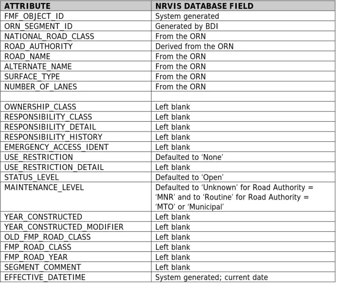
Table 5 - MNR Road Segment Attributes on Initial Data Load from Ontario Road Network (ORN)
ATTRIBUTE NRVIS DATABASE FIELD
FMF_OBJECT_ID System generated
ORN_SEGMENT_ID Generated by BDI
NATIONAL_ROAD_CLASS From the ORN
ROAD_AUTHORITY Derived from the ORN
ROAD_NAME From the ORN
ALTERNATE_NAME From the ORN
SURFACE_TYPE From the ORN
NUMBER_OF_LANES From the ORN
OWNERSHIP_CLASS Left blank
RESPONSIBILITY_CLASS Left blank
RESPONSIBILITY_DETAIL Left blank
RESPONSIBILITY_HISTORY Left blank
EMERGENCY_ACCESS_IDENT Left blank
USE_RESTRICTION Defaulted to ‘None’
USE_RESTRICTION_DETAIL Left blank
STATUS_LEVEL Defaulted to ‘Open’
MAINTENANCE_LEVEL Defaulted to ‘Unknown’ for Road Authority = ‘MNR’ and to ‘Routine’ for Road Authority = ‘MTO’ or ‘Municipal’
YEAR_CONSTRUCTED Left blank
YEAR_CONSTRUCTED_MODIFIER Left blank
OLD_FMP_ROAD_CLASS Left blank
FMP_ROAD_CLASS Left blank
FMP_ROAD_YEAR Left blank
SEGMENT_COMMENT Left blank
EFFECTIVE_DATETIME System generated; current date
NRVIS 3.3 attributes for which no data or information exists during the migration phase will become part of a future maintenance strategy developed by a District or Region based upon resources and /or priorities.
4.1.2 Districts – Roles and Responsibilities
Districts will act as Stewards of the resource access roads data class and be responsible for the spatial and tabular editing data within their respective administrative boundaries.
Staff resources and the time needed to complete the migration phase will vary by District due to a number of variations, e.g. size of the District, Districts in southern Ontario as compared to northern Ontario, the number of kilometres of roads, ORN data captured, and past District activities in updating their spatial and tabular roads data. These factors need to be taken into account when estimating time and resource requirements.
Recent efforts by Districts to update their data to improve quality by denoting retired roads and meeting obligations related to road network responsibilities with local forest companies will only be beneficial during this migration process.
Districts and or Regions can set priorities related to areas of their responsibility, or migration may be based upon forest management plans and their schedules, etc. They may choose to define priority areas based on administrative boundaries such as FMU’s or Area boundaries. If Districts or Regions have not started discussions with their local SFL holders, they should refer to the decision tree provided in the “Forest Roads and Water Crossings Initiative - Forest Industry-MNR Task Team Report – Responsibility” and the Crown Land Roads Manual (CLRM) when available.
Special Note:
Updates to municipal roads and provincial highways within the NRVIS roads layer are the responsibility of Base Data Infrastructure staff in their role as data stewards for these roads. In some cases a District could act as the road authority and data steward for roads in a municipality, e.g. there may be cases where a municipality has no ability to collect or provide digital data and the District has a need for local roads information, or there may be an
agreement between a District and a municipality to share data.
In all cases of data sharing, the MNR must ensure there are no Intellectual Property or Copy Right violations. The MNR on behalf of the government of Ontario has a legal obligation to ensure that any roads data entered into NRVIS and the ORN is done so under a license that allows the MNR to further distribute a partner’s data.
To avoid any potential legal issues, reduce confusion and avoid duplication, District staff and Base Data Infrastructure staff should consult and share information when engaging local or regional municipalities in sharing roads data. Base Data Infrastructure staff and their telephone numbers are listed in Appendix C.
4.1.3 Proposed Data Migration Approach
1. Assign a Project Management Lead 2. Identify positions and roles such as:
A Roads Data Steward assigned within the District to be the keeper of all roads related data/information and to monitor the migration process. It may not be necessary for the individual to be completely familiar with the data however, he/she should know where it is located. Datasets would include:
- bridge inventory - water crossing data - FMP road classifications - road use strategies
- Local Roads Board agreements, etc. Often this position is held by the District GSO.
Dedicated GIS Staff are necessary to implement and successfully complete the migration process into the new NRVIS 3.3 roads layer. It is beneficial to select an individual that has the opportunity to commit to the project until migration is completed. This will ensure continuity and integrity of the final product.
Resource Staff in the MNR, Industry and other government agencies (Federal and
Municipal) who are familiar with the land base will be integral to identification of drivable roads.
Planning Staff from MNR, Industry and other government agencies (Federal and Municipal) will be required.
3. Assemble available data, maps, images, reports, etc. on roads within your District that can assist in conducting a gap analysis, e.g.
- NRVIS 3.2 roads layer - External roads datasets
- Other road datasets, e.g. forest industry - GPS data
- Supplementary aerial photography or high resolution imagery - Roads Commissions/Boards road information
- Bridge and water crossing inventories - FMP road Strategies
- Annual Report roads data - Road inspection reports
4. Review Data Holdings
It is recommended that the Roads Data Steward and GIS staff catalogue data sources documenting projection, datum, accuracy, currency, extents, completeness and any other details necessary. Keep the catalogue updated as migration progresses.
To estimate the scope of spatial editing required, it may be useful to produce a series of map products displaying the new NRVIS 3.3 road features and the roads data regularly used by the District. Areas of discrepancy will require review /evaluation by GIS and Resource staff to determine the best source.
Districts and Sustainable Forest Licence holders should review roads data and verify known roads or identify retired roads. Districts should conduct similar reviews with other agencies they work with to acquire additional or missing attribute information. 5. District Road Geometry vs. ORN Geometry - Considerations
Generally, it is expected that the ORN geometry (collected to a positional accuracy of 10 metres or better at the 90 % confidence interval) will remain as the source geometry in the NRVIS road segment layer.
There may be situations where a MNR District office has information that is more accurate either within NRVIS 3.2 roads or external to the NRVIS database, however, District staff can only edit spatial features where the road authority is designated as the MNR.
Districts must contact Base Data Infrastructure staff with information to support changes to road segments where the road authority is designated anything other than the MNR. 6. Data Migration
NRVIS tools will provide functionality for updating Resource Access Roads, Barriers and Historic Roads. Tools include import of geometry and mapping of tabular data. GIS staff must adhere to data standards rules when adding or changing source geometry (see section 3.0). Tasks may include:
- replacement of existing road segments with more representative geometry - importing new feature geometry into the NRVIS 3.3 roads layer
- transfer and removal of historical road features - update of tabular data from various sources
The most efficient method for populating the new NRVIS 3.3 roads layer is to export all existing NRVIS 3.2 road segment data from NRVIS to a shapefile or use an existing external roads dataset. From the information collected in Step 4 above, add the necessary fields as described under “entity attributes” in Appendix A, Part A. Then add as many attributes as possible before moving the data to the NRVIS 3.3 roads layer. Undertake a final attribute verification with the NRVIS 3.3 MNR roads Concrete Class segment layer to ensure that the imported attributes are compatible and massage the data as necessary. Devise a plan to import the shapefile in groups of no more that 500 segments per version, and import the data using the Multi-feature Update Tool instead of the Import Shapefile tool.
There are six (6) types of edits: Shape on MNR roads
MNR can update and post roads with road authority = MNR only. If you suspect the road authority is incorrect, contact Base Data Infrastructure staff.
Shape on non-MNR roads
MNR cannot update roads with road authority other than MNR. These updates must be sent to the Base Data Infrastructure staff for posting or rejection. ORN attributes on MNR roads
There are seven (7) ORN attributes brought over to the Resource Access Roads Layer. These ORN attributes can be edited only for segments with road
authority = MNR.
ORN attributes on non-MNR roads
These attributes cannot be edited by MNR. If you suspect the attribute value is incorrect, contact Base Data Infrastructure to discuss.
MNR attributes on MNR roads
MNR attributes can be updated for all roads in the database with road authority = MNR.
MNR attributes on non-MNR roads
MNR attributes can be updated for all roads in the database with road authority other than MNR.
For more detailed information on networks, barriers, private roads, etc please refer to Appendix B, Part E – Guidelines for Editors and Users of the NRVIS 3.3 Roads Layer.
4.2 Data Maintenance
4.2.1. Roles and Responsibilities
There are a variety of agencies who will be involved in resource access road data maintenance. Most maintenance will be the responsibility of the MNR. Table 6 shows the roles and
responsibilities for resource access road data, with the organization units set in order of authority.
Table 6
ROLE Org Unit 1 Org Unit 2 Org Unit 3 Org Unit 4
Custodian GI Branch District
Standards GI Branch ORN
Metadata LIO GI Branch District
Data Management NRVIS ORN Data Collection District Forest
Industry Parks Ontario Data Entry or
Provision District Forest Industry Parks Ontario Fire Management Data Retention GI Branch ORN District
The timing of resource access roads edits will vary somewhat but generally will be continuous. In those Districts with Forest Management Plans (FMP), the majority of changes will likely come with the FMP Annual Report roads data as required by the Forest Information Manual.
While NRVIS will enforce the collection of specific data attributes, the District acting as Data Stewards are responsible for ensuring that data is collected appropriately and meets the minimum spatial standards for resource access roads as set out by the Custodian.
The NRVIS 3.3 roads layer is designed to provide spatial and tabular data at the segment level (with linkages to barrier features) as well as the network level. Networks can be created to meet program area needs. For more detail on networks, see Appendix B, Part E.
4.2.1 Business and Technical Considerations
Data maintenance cycles and technical approaches used to update the MNR’s resource access roads data will vary District by District. Priorities for Districts may be driven by such factors as:
• where and when to collect road updates, e.g.
- immediate vs. long term business needs - known data issues needing attention - annual work plans vs. special projects
- legislation and policies to adhere to and leverage
• what and how to collect road updates, e.g.
- update road geometry first and attributes later, or vice versa - GPS vs. imagery collection of road geometry
- notifications from staff who travel roads and can report to the District Data Steward on particular road attributes, e.g. drivability of a road can be confirmed /updated - replacement of roads data with improved data from external partners
For Districts within the “Area of Undertaking”, some resource access roads data will come from forest industry as prescribed by the Forest Management Planning Manual (FMPM) and the Forest Information Manual (FIM). These two documents detail the timing and content of roads data to be exchanged between the MNR and forest industry.
The Crown Land Roads Manual provides an overview and context for the planning,
management and administration of all roads on Crown land. It also contains a series of Public Lands Act policies and procedures that guide the administration and management of roads. Road use strategies developed by a District based upon these policies and procedures will influence priority areas within a District where updates to roads data will occur.
As part of the Ministry’s Mobile GIS Taskforce, the GPS Working Group is assessing the current situation of mobile GPS across the organization. The Working Group is to create a document in early 2007 with guidelines and best practices for the use of GPS technology within the Ministry. Their document will be posted to the MNR’s Geomatics Portal when complete.
With the increasing acquisition of imagery across the province, various tools and techniques to leverage these products will begin to be developed. The Geographic Information Branch will be undertaking a pilot project in 2007-08 to use imagery for purposes of change detection and road centreline collection. This information will be shared with NRVIS editors when complete.
APPENDIX
A
–
DATA
DICTIONARY
Included in Appendix A are the Business View Logical Data Model and Data Dictionary for:
Part A - MNR Road Segment and MNR Road Network Part B - MNR Road Retired
Part A - MNR Road Segment & MNR Road Network:
MNR ROAD SEGMENT
FMF Object Id O ORN Segment ID National Road Class Road Authority O Road Ownership Class O Road Responsibility Class O Road Responsibility Detail O Road Responsibility History O Emergency Access Identifier O Road Name
O Road Alternate Name Road Use Restriction O Road Use Restriction Year O Road Use Restriction Detail Road Surface Type Road Status Level Road Maintenance Level O Road Year Constructed O Road Year Constructed Modifier Road Number Of Lanes O Old FMP Road Class O FMP Road Class O FMP Road Year O Road Segment Comment MNR ROAD NETWORK
FMF Object Id
Road Network Business Identifier O Road Network Group
O Road Network Description O Road Network Comment O Road Network Maintenance O Road Network Monitoring O Road Network Access O Road Network Future O Road Network Transfer Year
GEOGRAPHIC UNIT COMPONENT GEOGRAPHIC UNIT CONSOLIDATION
GEOGRAPHIC UNIT
Geo Consolidation Components
Business View Logical Data Model
Information Class: MNR Road Consolidation
Subset: MNRROAD
Geographic Unit Breakdown Geographic Unit Aggregate Type Part Of ContainsEntity : MNR ROAD SEGMENT Entity Description:
A road segment is the linear geometry of the road.
Road segments can be consolidated into networks using the MNR Road Network entity. Each MNR ROAD SEGMENT May be Part Of One or more MNR ROAD NETWORK(s).
To exist in the Road Segment layer the road must have actually existed as a path supporting conventional four-wheel street legal vehicles. Specifically not to be included are paths constructed for off-road vehicles (e.g. ATV trail) and temporary paths related to forest management (e.g. skidder trail) or forest fire management (e.g. rehabilitated fire trail)
The MNR Road Segment layer will contain all road geometry found in the Ontario Road Network (ORN) layer along with some ORN attribute information. Selective updates to the MNR Road Segment layer will be passed back to the ORN database operator for consideration as ORN updates.
Entity Attributes:
FMF Object Id Integer (long) 13 Mandatory
System generated identifier, unique at the application level.
ORN Segment ID Integer (long) 13 Optional
The identifier for the source ORN segment. This attribute is not changeable by the user.
If the segment is sourced from ORN then it must have a ORN segment identifier.
More than one NRVIS road segment may belong to the same ORN segment and have the same ORN Segment ID.
National Road Class Character (variable length string) 30 Mandatory A functional (versus administrative) based classification system applied to all ORN road
segments.
The National Road Class list is as follows:
Freeway - An unimpeded, high speed controlled access thoroughfare for through traffic with typically no at grade intersections, usually with no property access or direct access and which is accessed by a ramp. Pedestrians prohibited.
Expressway/Highway - A high speed thoroughfare with a combination of controlled access and intersections at grade level.
Arterial - A major thoroughfare with medium to large traffic capacity
Collector - A minor thoroughfare mainly used to access properties and to feed traffic with right of way.
Local / Street - A low speed thoroughfare dedicated to provide full access to the front of properties.
Local / Strata - A low speed thoroughfare dedicated to provide access to properties with potential public restriction, trailer parks, first nations, strata or private estates.
Local / Unknown - A low speed thoroughfare dedicated to provide access to the front of properties but for which the access regulations are unknown.
Alleyway / Laneway - A low speed thoroughfare dedicated to provide access to the rear of properties.
Ramp - A system of interconnecting roadways providing for the controlled movement between two or more roadways.
Resource / Recreation - A narrow passage which has as a primary function access for resources extraction and also may have a role in providing an access for the public to back country. Rapid Transit - A thoroughfare restricted 24 hours a day, for the sole use of public
transportation buses.
Service - A stretch of road permitting vehicles to come to a stop along a Freeway or Highway. These include weigh scales, emergency lanes, lookouts and rest areas.
Winter - A road that is only useable during the winter months when conditions allow for passage over lakes, rivers and wetlands.
Note: Although not explicitly stated, it is expected that most of the NRC classes will be reserved for permanent all-weather roads belonging to the Municipal & MTO road authorities. This
means that most roads managed by MNR will be of the 'Resource/Recreation' class and occasionally 'Local/Strata' or 'Winter' class.
This national road classification is found in the Ontario Road Network data model. Permissible Values: Freeway Expressway/Highway Arterial Collector Local/Street Local/Strata Alleyway/Laneway Ramp Resource/Recreation Rapid Transit Service Winter
Road Authority Character (variable length string) 10 Mandatory
The provider of road segment updates to Ontario Road Network contractor.
This attribute is actually a grouping of the detailed road authority name into the following class groups: MNR, MTO, Municipal, Other.
Definitions: 'MNR' means Ministry of Natural Resources; 'MTO' means Ministry of
Transportation; 'Municipal' means Road Authority is a municipal government; 'Other' means none of the above.
A road segment must be assigned to one and only one Road Authority. Permissible Values:
MNR MTO Municipal Other
Road Ownership Class Character (variable length string) 40 Optional Legal ownership of the road right-of-way and authority to assign responsibility for a road to another party.
Classification: Unalienated Crown Land, MTO, Ontario Parks, Conservation Reserve, Municipal, First Nation, Federal, Private (Crown agency), Private (Non-Crown), Other (Crown Surface Rights), Other
The particular MNR business need for this attribute is to track which roads are on Crown Land even though the responsibility for the road may be assigned to a third party (e.g. SFL , Local Roads Board, etc.).
The owner of the right-of-way is a stakeholder in the road regardless of who is the 'Road Authority' and who has 'Responsibility' for the road.
In some areas it may be possible to derive this information from a topological overlay with a land ownership layer.
Permissible Values :
Unalienated Crown Land MTO Ontario Parks Conservation Reserve Municipal First Nation Federal
Private (Crown agency) Private (Non-Crown)
Other (Crown Surface Rights) Other
Road Responsibility Class Character (variable length string) 30 Optional A classification of the agents listed in the Road Responsibility Detail attribute.
Classification: Ministry of Transportation (MTO), Municipal, Ministry of Natural Resources (MNR), Sustainable Forest Licence (SFL), Aggregate License Holder, Local Roads Board, Road
Commission, Mining Company, Power Company, First Nation, Ontario Parks, Federal, Other Public, Other Private, Other Mixed.
Responsibility Class and Detail are linked in that there should be not one without the other. This attribute should be considered mandatory for all roads on Crown Land and perhaps all roads of which 'MNR' is the Road Authority.
Operational responsibility for roads on Crown Land may be assigned to third parties or to a specific Ontario government org unit.
Permissible Values: MTO
Municipal MNR SFL
Aggregate License Holder Local Roads Board
Road Commission Mining Company Power Company First Nation Ontario Parks Federal Other Public Other Private Other Mixed
Road Responsibility Detail Character (variable length string) 80 Optional Name of the specific group or individual legally responsible for activities associated with a road including condition and maintenance.
May refer to the reference number of a shared use agreement involving a number of parties. Responsibility Class and Detail are linked in that there should be not one without the other. This attribute should be considered mandatory for all roads on Crown Land and roads which the MNR is the Road Authority.
For private roads on Crown Land it is appropriate to list the reference to the legal agreement (e.g. Land Use Permit; Memorandum of Understanding) instead of the name of the individual due to privacy issues.
Road Responsibility History Character (variable length string) 500 Optional Details of responsibility for the road segment being transferred between parties.
Needed to track responsibility history for liability purposes.
A road on Crown Land may initially be the responsibility of forest industry who may eventually turn it back to the MNR when forest management operations are complete. The MNR may assign the road to another interested party through a legal agreement (e.g. Land Use Permit; Memorandum of Understanding; etc.).
Emergency Access Identifier Character (variable length string) 80 Optional The identifier for the segment used to dispatch and route emergency service vehicles (e.g. fire, police, ambulance). This may be a compound key combining a jurisdiction with an identifier. MNR Fire Management will be participating in Fire & Emergency Response Plans for northern settlements and communities as part of an initiative being led by the Ontario Fire Marshall. Road networks with Emergency Access Identifiers will be part of these plans.
Note: The standard for emergency access identifiers is not uniform across Ontario; most municipalities have a 911 system based on civic addressing.
Road Name Character (variable length string) 150 Optional
The road’s primary (or official) street name.
Within a single municipal jurisdiction, a road's official name may be unique. There is no
jurisdiction framework to assign and maintain unique official names in unorganized territory (i.e. most of Northern Ontario) .
Road Name value will be sharable between MNR Road Segment and the ORN.
Road Alternate Name Character (variable length string) 150 Optional Road name that has no official status but is used or known by the general public.
Road Alternate Name value will be sharable between MNR Road Segment and the ORN.
Unlike in the Ontario Road Network data model, where more than one alternate road name can be maintained, this data model only allows for one alternate road name.
Road Use Restriction Character (variable length string) 25 Mandatory Known restriction on use of the road by the general public.
Restriction classification: 'None' (No known Restriction); 'Conditionally Restricted' (restriction involves particular uses and seasons); 'Restricted' (closed to the public; permit or permission required).
Defaults to 'None'.
Details of the restriction can be stored in the Road Use Restriction Detail attribute field. Class: Code Description
Permissible Values: None
Conditionally Restricted Restricted
Road Use Restriction Year Character (variable length string) 15 Optional Reference to the year that the current road use restriction was first in effect.
The text string entered may be the actual year, a range of years, and approximate year or a before or after year.
For the actual year, only the four digits of the year should be entered (e.g. '1994')
For a range of years, the two four digit years should be entered with a hyphen in between (e.g. '1992-1994')
For an approximate year, the four digit year should be prefixed with '~' (e.g. '~1994')
For before a year, the four digit year should be prefixed with '<' (e.g. '<1993', meaning 'less than 1993)
For after a year, the four digit year should be prefixed with '>' (e.g. '>1993', meaning 'greater than 1993)
Used for audit and reporting purposes related to road use strategies
Road Use Restriction Detail Character (variable length string) 150 Optional Brief details of the road use restriction referred to in the Road Use Restriction attribute, particularly when the Road Use Restriction is 'Conditionally Restricted' or 'Restricted'
Road Surface Type Character (variable length string) 10 Mandatory The surface type of the road whether paved, (unpaved) gravel, or (unpaved) unsurfaced. This attribute is somewhat exchangeable with ORN attributes Pavement Status and Surface Type
Winter roads will be classified by their operating surface which is expected to be 'Unsurfaced ' in most instances. Defaults to 'Unknown'. Permissible Values: Paved Gravel Unsurfaced Unknown
Road Status Level Character (variable length string) 20 Mandatory
An indicator of how drivable the road is.
Definitions for permitted values: 'Open' (2W drive vehicles); 'Limited' (may require 4x4 truck); 'Not Passable' (due to assessed conditions); 'Decommissioned' (not drivable as a result of a known decommissioning process); 'Inaccessible' (can't be assessed due to barrier or obstruction in road network), 'Winter' (only passable when maintained as a winter road), 'Unknown' (status not known)
Defaults to 'Unknown'
Along a road network, change in road status may be logically related to objects in the Barrier (point) layers where a barrier or physical control measure may occur at the same location as a change in road status.
For older roads 'Inaccessible' is expected to be common when it is not possible to accurately assess their condition; for more recent roads 'Decommissioned' is expected to be more common. Permissible Values: Open Limited Not Passable Decommissioned Inaccessible Winter Unknown
Road Maintenance Level Character (variable length string) 15 Mandatory Maintenance planned for the road.
Meanings for permissible values: 'Routine' means road maintained on a continuous basis to keep expected condition constant; 'Limited' means maintenance is limited to things like maintaining water crossings required to keep the road passable; Not Maintained means no official maintenance is carried out except for action to address environmental or public safety issues; 'Unknown' means status not known.
Defaults to 'Unknown'
Winter roads will be classified by their operating maintenance level. Permissible Values :
Routine Limited
Not Maintained Unknown
Road Year Constructed Character (variable length string) 15 Optional The year in which the road segment was constructed
If construction spans more than one year then the year that the segment was first opened to vehicular traffic.
The text string entered may be the actual year, a range of years, and approximate year or a before or after year.
For the actual year, only the four digits of the year should be entered (e.g. '1994')
For a range of years, the two four digit years should be entered with a hyphen in between (e.g. '1992-1994')
For an approximate year, the four digit year should be prefixed with '~' (e.g. '~1994')
For before a year, the four digit year should be prefixed with '<' (e.g. '<1993', meaning 'less than 1993)
For after a year, the four digit year should be prefixed with '>' (e.g. '>1993', meaning 'greater than 1993)
To assist in querying the text sting entered, the Road Year Constructed Modifier attribute must be populated if a Road Year Constructed value is entered.
Road Year Constructed Modifier Character (variable length string) 15 Optional
A mandatory modifier to the Road Year Constructed attribute. Meanings of permissible values:
'Actual' means the year is known;
Approximate' means the year is not known for sure but somewhere about the year entered ; 'Before' means that the actual year is not known but it was sometime before the year entered; 'After' means that the actual year is not known but it was sometime after the year entered; 'Range' means that the entry represents a range of years (e.g. 1999-2004)
The Road Year Constructed Modifier required if 'Road Year Constructed' populated. Permissible Values : Actual Approximate Before After Range
Road Number Of Lanes Integer (short) 2 Mandatory
The number of lanes on the road segment. A lane is defined as the distance wide enough to accommodate one motorized vehicle.
Where there are no indications representing the lanes on the road surface, the number of lanes can never be higher than two (2). If the width of the roadbed is five (5) metres or more, the road is considered to be wide enough to allow for two vehicles traveling in opposite directions to pass and it is therefore indicated as a two-lane road.
If the roadbed is overgrown or deteriorated to such a degree that a single vehicle can not be accommodated then the number of lanes can be indicated as zero (0).
Old FMP Road Class Character (variable length string) 10 Optional
The FMP road class in use before plans due in 2007. The classes are Primary, Secondary, and Tertiary and the class definitions were based on how long a time period the road was planned to exist.
If Road Responsibility is coded 'MNR' or 'SFL' then either Old FMP Road Class or FMP Road Class must be populated. Since the FMP Road Class value must come from a forest management plan, only the Old FMP Road Class value should be changed or populated after the fact. Permissible Values:
Primary Secondary Tertiary
FMP Road Class Character (variable length string) 11 Optional The FMP Road Class according to the Forest Management Planning Manual and Forest Information Manual for forest management plans effective 2007 and beyond. The road classification is Primary, Branch and Operational.
If Road Responsibility is coded 'MNR' or 'SFL' then either Old FMP Road Class or FMP Road Class must be populated.
FMP Road Class value must come from an approved forest management plan and not be changed after the fact. The FMP Road Class entered is tied to the FMP Road Year value. Permissible Values:
Primary Branch Operational
FMP Road Year Numeric 4 Optional
The first year year of the five-year forest management planning period phase of when the road was planned as a road of the FMP Road Class.
Required if 'FMP Road Class' is populated as it ties the road to a specific forest management plan.
Road Segment Comment Character (variable length string) 100 Optional Brief comments about the road segment
Entity : MNR ROAD NETWORK Entity Description:
A road network is a consolidation of one or more road segments and relies on the road segment for its geometry. A road segment may belong to one or more road network consolidations. Each MNR ROAD NETWORK Must Contain One or more MNR ROAD SEGMENT(s).
Entity Attributes:
FMF Object Id Integer (long) 13 Mandatory
System generated identifier, unique at the application level.
Road Network Business Identifier Character (variable
length string) 80 Mandatory
A text string containing the business identifier for the road network assigned by the author of the network.
Road networks can be used for a number of purposes, including naming routes (e.g. ' Highway 17', 'Trout Lake Road'), and organizing roads for forest management purposes or road use management strategies.
This is the identifier that might be used to annotate a map.
This is identifier could be used as a link to a Road Network Management Strategy database (for SFL and MNR road networks)
Road Network Group Character (variable length string) 80 Optional
A user defined text string allowing the road network to be assigned to a sub-type or group. This attribute can be used to group Business Identifiers so that a Group/Business Identifier set would uniquely identify a particular road network A group could be used for selection when mapping and map labelling A group might identify the author of the road network.
Road Network Description Character (variable length string) 500 Optional Description of the road network. May include why the network was created.
Road Network Comment Character (variable length string) 100 Optional Brief comments about the road network.
Road Network Maintenance Character (variable length string) 250 Optional Description of the maintenance plan for the road network.
Used for audit and reporting purposes related to road use strategies
Road Network Monitoring Character (variable length string) 250 Optional Description of the monitoring program for the road network.
Used for audit and reporting purposes related to road use strategies
Road Network Access Character (variable length string) 250 Optional Description of the access controls planned or in place on the road network.
Used for audit and reporting purposes related to road use strategies.
Road Network Future Character (variable length string) 80 Optional MNR intent for the future use of the road once it is transferred to MNR responsibility.
Used for audit and reporting purposes related to road use strategies.
Road Network Transfer Year Character (variable length string) 15 Optional Year that the road segments of the network were or are expected to be transferred to MNR responsibility.
Part B: MNR Road Segment Retired:
GEOGRAPHIC
UNIT
GEOGRAPHIC
UNIT
COMPONENT
Geographic Unit
Breakdown
ROAD SEGMENT RETIRED
FMF Object Id
Entity : ROAD SEGMENT RETIRED
Entity Description:
A retired road segment comes from the Road Segment layer when the road segment is no longer a road. Instead of deleting a road segment from the database it is moved to the Road Segment Retired layer.
Entity Attributes:
FMF Object Id Integer (long) 13 Mandatory
System generated identifier, unique at the application level.
Road Segment Retired Comment Character (variable length string) 100 Optional A brief comment related to the retired road segment.
Part C: MNR Road Barrier: GEOGRAPHIC UNIT GEOGRAPHIC UNIT COMPONENT ROAD BARRIER FMF Object Id Road Barrier Type O Road Barrier Group
O Road Barrier Business Identifier O Road Barrier Year
O Road Barrier Responsibility O Road Barrier Description O Road Barrier Comment
Geographic Unit Breakdown
Entity : ROAD BARRIER Entity Description:
A road barrier is a point feature related to the restriction or control of access to a road segment or road network.
Entity Attributes:
FMF Object Id Integer (long) 13 Mandatory
System generated identifier, unique at the application level.
Road Barrier Type Character (variable length string) 15 Mandatory
The type of barrier restricting passage along the road.
Meanings for selected permissible values: 'Berm' means berm and/or ditch; 'Water' means water crossing bridge or culvert removed.
Permissible Values : Gate Berm Sign Water Other Permanent Other Removable
Road Barrier Group Character (variable length string) 80 Optional
A user defined text string allowing the barrier to be assigned a group. [RD_BAR_GRP]
This attribute can be used in combination with the Road Barrier Business Identifier to uniquely identify the barrier or to assign a group for selection, mapping and map labeling.
Road Barrier Business Identifier Character (variable length string) 15 Optional The business identifier for the road barrier.
Road Barrier Year Character (variable length string) 15 Optional The year that the road barrier came into effect.
Can be expressed as an actual year, a range of years, and approximate year using the prefix '~' or before or after a specific year using the prefix '>' or '<'.
Used for audit and reporting purposes related to road use strategies.
Road Barrier Responsibility Character (variable length string) 80 Optional The name of the organization unit that is responsible for the barrier.
In most cases this will be the same as the responsibility for the related road; however there may be instances where this is not the case or where road responsibility changes at the barrier.
Road Barrier Description Character (variable length string) 500 Optional Additional details about the road barrier.
Further information about the barrier can be stored here including date of installation (e.g. if it's a locked gate then who has the key or if it's a sign then who put it up, what direction does it face, and what does it say)
Road Barrier Comment Character (variable length string) 100 Optional Brief comments about the barrier.