Munich Personal RePEc Archive
Exploring the Influence of Colonial
Railways on Java’s Economic Geography
Brata, Aloysius Gunadi
Atma Jaya Yogyakarta University
7 July 2017
1
EXPLORING THE INFLUENCE OF COLONIAL RAILWAYS ON JAVA’S ECONOMIC
GEOGRAPHY*
Aloysius Gunadi Brata
Department of Economics, Atma Jaya Yogyakarta University, Indonesia (Corresponding e-mail address: [email protected]/[email protected] ) Draft - July 2017
Abstract
This study explores the impact on Java’s economic geography of railways built by the Dutch
colonial government. Pre-1940 Dutch railway construction affords an historical experiment on the spatial distribution of economic activities across urban Java both before and after 1940. Using city data for over 100 years, the study finds that the railways had a short-term impact on the distribution of population, but that in the long run colonial railway investment lost its advantages. Until 1930, the railways substituted for the Great Mail Road. Between 1930 and 2010, however, the Great Mail Road regained an earlier importance in shaping urban Javanese patterns. The study also draws important lessons for recent Indonesian infrastructure development in Indonesia, notably in regard to the railway system itself.
Key words : colonial railways, history, economic geography, Java JEL Codes : N75, N95, R12
INTRODUCTION
Spatial distribution of economic activities tends to persist. Some locations are densely populated while population density in others is relatively low. Debate remains on the relative importance of difference causes of the persistence of cities or regions in terms of both of their locations and their relative sizes (Henderson et al. 2017). There are three groups of factors that economists might refer to explain the persistence of distribution of economic activity (e.g. Davis & Weinstein 2002, Maloney & Caidedo 2015, Henderson et al. 2017, Michalopoulus & Papaioannou 2017).
The first explanation of how population is distributed refers to ‘first nature
geography’, which is concerned with locational fundamentals. This includes physical
geography of coasts, mountains, or other natural endowments. Following this argument, for
* Paper prepared for presentation at the 6th IRSA International Institute: Maritime Infrastructure and
2
instance, city that is located in coastal area tends to have greater accessibility to trade than landlocked ones. This, in turn, gives an opportunity to that city to grow faster. This first-nature geography basically reflects the relationship between people and the first-nature. The second possible explanation is ‘second-nature geography’, also known as agglomeration economies, which represents the interaction of economic agents in geographic space. Knowledge and information spillovers, industrial specialisation, human capital, institutional quality, among others, might produce agglomeration advantages. Market size, as a result of gain of trade, could also creates agglomeration advantages. The process of agglomeration might also be explained by the first-nature geography characteristics (see Gallup et al. 1999, Gatoa & Mastinu 2017).
3
One of the historical factors that may affect on spatial distribution of population is railways built during the colonial era. The role of railways system on economic development has been intensively studied. Jenk (1944) stated that railways system played a central role in American economic development. Meanwhile, Atack et al. (2010) found that the impact of railways on population density in the American Midwest was small, confirming that mid-western railways were not built ahead of demand, and that development in this area was already well under way when the railways was introduced. This finding leads to argue that railways were built not randomly but purposely. In other words, railways development is not a fully exogenous shock, as has been observed by Fishlow (1965, see Atack et al. 2010). On the urbanisation in the American Midwest, however, Atack et al. (2010) found that the impact of railways was quantitatively large.
Franch et al. (2013) found that railway was an important factor that changed population distribution in Spain during the period of 1900 to 1970. Specifically, they identified that municipalities that were located further away from the railway network and from the coast experienced a significant lost of population. But, they also noted that the impact of the railway on population growth was not equally strong for all locations. Investigating the impact of historical railways—the 19th century railways—on urban growth in Sweden, Berger & Enflo (2017) found that town with access to railways experienced increases in population, but this growth mainly reflected a relocation of economic activity. They concluded that the transitory shock of the first railroads gave rise to path dependence in the location of economic activity.
4
terms of public physical capital (transport) and human capital (the settlers)post-independence, did not affect the railways locations as they remain relatively more developed today. Jedwab & Moradi (2016) found that railways had large impacts on the distribution of economic activities during the colonial period in Ghana, and these impacts have persisted until recently, although railways collapsed and road networks expanded after independence. This finding indicates that colonial railways as a transportation revolution had permanent effects on the spatial distribution of economic activities in developing countries.
The aim of this paper is to explore the influence of railways built by the Ducth colonial on the economic geography of Java. This colonial railways has been described in several studies as an important factor in the development of Java, or as a back bone for the economy. Ricklefs (2001), for instance, argued that economic development and the concern for indigenous welfare were linked only in infrastructure projects by the Dutch colonial, such as a major expansion of railways and tramways. Meanwhile, Huff (2012) stated that this railways expansion was instrumental in the growth of large inland urban centers in Indonesia, and in Java, in particular. By 1930s, railways system in Java was comparable to European countries (Huff 2012), and this contributed in shaping Java became a modern agro-industrial economy in 1900s (Dick 2000).However, the role of this transportation network tended to decline in post-independence era (McCawley 2015).
5
then followed by a section of data sources and econometric approach. Section 4 presents main empirical results. And the last section provides preliminary conclusions of the study.
RAILWAYS IN JAVA: FROM COLONIAL ERATO THE 2000s
The railways system in Java significantly improved geographical accessibility over the island, adding the existing road system—the Great Mail Road (de Groote Postweg)†—that has been built at the command of Governor-General Herman Willem Daendels during his rule in Java from 1808 to 1811 (Nas & Pratiwo 2002). In 1840, Colonel J.H.R van der Wijk, has proposed to develop mobile transportation mode in Java, from Surabaya to Batavia via Surakarta, Yogyakarta, and Bandung. This proposal was, in particular, related to military and economic interests of the colonial (Irsyam 2013). Since the development of railways was initiated by the Dutch colonial government, it then can be concluded that political decisions were central to the infrastructure development in Java (Huff 2012). It should be noted that according to Knaap (1989), the construction of infrastructure in Indonesia, including railways, did not start effectively until after 1890 (see, Van der Eng 2006).
The first line of railways in operation was between Semarang and Tanggung (26 km), opened in 1867, and this was the first railway in Southeast Asia, 14 years after the opening of the first railway in British India. In the 1930s the total length of rail- and tramway system in Java measured more than 5,000km (see, Reitsma 1925, 1928). The density of railways system in Java, then, was relatively equal to European countries, and elsewhere in East Asia only
Japan could compare to Java (Dick 2000, Huff 2012). In short, large cities and smaller towns in Java were connected, and ports and hinterlands were also connected, which contributed
†A recent study by Rogowski et al. (2017) find strong evidence that postal services as a measure of
public infrastructure was played a central role in economic development in the US over the past two centuries. For instance, counties endowed with a greater density of post offices experienced higher income and manufacturing in the succeeding century.Concerning this interesting finding, we should
note that the Great Mail Road in Java is not identical to the postal services in Java as the Post-
6
in modernising industrial economy in Java in the 1900s. The railways linked the agro-industrial sector with world markets, suggesting that the railways industry was highly dependent on the agricultural products.
[image:7.595.69.530.453.680.2]There were three players in the development of railways industry in Java in the colonial era: state company, national private company, and regional or local company. The biggest player was the State Railways (SS), with the length of rail by 1939 was 2,641 km (51%) that were constructed from 1878 until 1928. The served area of this state owned company were Banten, Jakarta, West Java, Central Java, Yogyakarta, and East Java. Meanwhile, the share of the Nederlands Indies Railways Company (NIS), a private company, in total length of rail- and tramways was 16%. The NIS railways was constructed between 1867 and 1924, indicating that the first railways operator in Java was private company, but the difficulty to achieve investment return pushed the colonial government to establish a state railway system. Othersmall companies served as regional secondary lines.
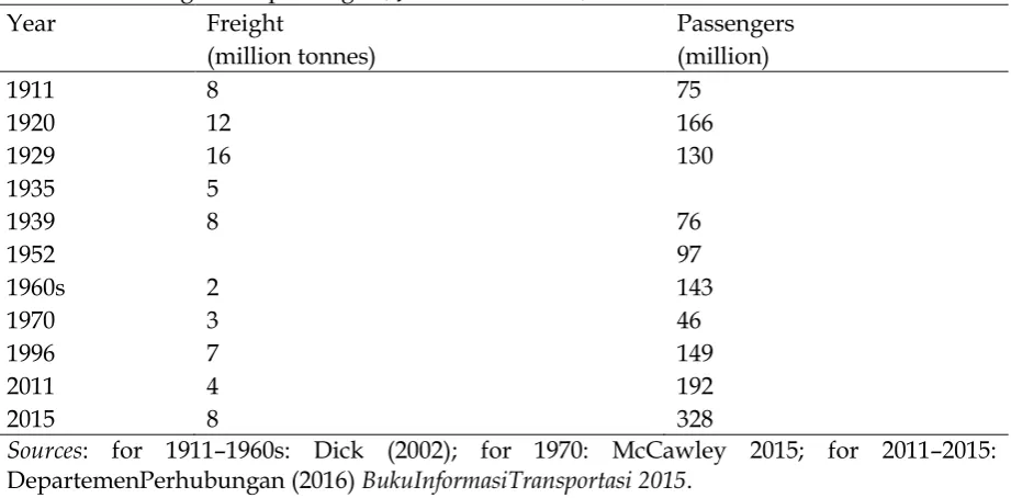
Table 1. Rail freight and passengers, Java and Madura, 1911–1996
Year Freight Passengers
(million tonnes) (million)
1911 8 75
1920 12 166
1929 16 130
1935 5
1939 8 76
1952 97
1960s 2 143
1970 3 46
1996 7 149
2011 4 192
2015 8 328
Sources: for 1911–1960s: Dick (2002); for 1970: McCawley 2015; for 2011–2015: DepartemenPerhubungan (2016) BukuInformasiTransportasi 2015.
7
freight as well as of passengers. Rapid expansion in the output of agricultural sector, especially sugar, contributed in increasing rail freight in 1929. But, the role of railways system tended to decrease after the Great Depression and post-colonial era. Several factors caused the collapse of railways in Java. Two important factors were competition with road mode, and the nationalisation and bureaucratic problems (see Dick 2002, McCawley 2015). Many lines were closed, mainly due to these lines were unable to sufficient profit. It is interesting that in 2000s there was a significant resurgence of the railways industry, especially in terms of the number of passengers. This indicates an achievement in improving the overall management of the rail system (McCawley 2015).
DATA SOURCES AND ESTIMATION METHOD
City data is the unit analysis of this study. This data covers the period of the colonial era (1880s–1930s) and 2000s. The pre-independence data is extracted from Huff (2012a, 2012b), whilethe 2000s data is taken from the latest census in 2010 (Penduduk Indonesia Menurut Desa Sensus Penduduk 2010) conduced by BPS Indonesia. Huff’s dataset covers cities, mostly with population 10,000 and over, in Java and Madura. The oldest available data in Huff (2012a, 2012b) is 1890. It should also be noted that the quality of population data in Java before 1900s was relatively poor, and the census in 1890 largely just a population count (Huff 2012b).
For the purpose of this study, and after taking a look at the latest data, some
8
was less than 10,000. However, one might expect that locations were being cities in 1890 would get benefits from the railways access and would able to grow faster.
The city data then matchwith the colonial railways data as appeared in a digital map prepared by Cahyono (2012).This map is produced using several historical reports on the development of railways in Java, in particular are Reitsma’s reports (1925, 1928; see also, Teeuwen 2010). This map provides information about the length, year of opening, and year of closing of each line. I follow Attack et al. (2010) and Berger & Enflo (2017) in creating a binary variable of railways access; it takes value of 1 if railway passes through city boundary, and 0 otherwise. This approach is rather simple than Jedwab & Moradi (2016) and Jedwab et al. (2017), besides the available digital map of railways allows me to visually identify the position of city on the railways networks in Java.
This study uses the year 1930 as a reference to create a dummy variable of railways accessibility at city level. The reason for this identification strategy is that after 1930 there was no substantial new colonial railways construction. The latest year of railways opening on the map was 1930. The result of this procedure is that in 1930 there were 82 cities with- and 15 cities without railways access. But, taking a look at the map, I also find that railways
in 25 of 82‘ railways cities’ have been closed, mainly after 1970. As already discussed, the
first rail line operated in 1867, but the oldest city data is 1890. Meanwhile, there were 34 cities that already had railways connection by 1890. This limits this study to detect whether the railways that were built before 1890 affected population in 1890.
9
coastal cities to receive gain from trade. Huff (2012a, 2012b) showed that in Southeast Asia, ease access to the sea was one of the main determinants of where, and which, cities grew, and whether small cities grew fast enough. These two control variables basically represent locational fundamentals. With regards to the competition between railways and other transportation modes, it needs to concern on the historical colonial road in Java—the Great Mail Road (Nas & Pratiwo 2002). I then create a dummy variable of 31 cities those were connected by this mail roads, it takes value of 1, and 0 for the others. The inclusion of these three control variables also allow us to compare the impact of the temporary and man-made historical shock, which is represented by the colonial railways, and locational fundamentals, and also the possible different impact on economic geography between the colonial railways and the Great Mail Road as the other man-made that is more historical.
This study focuses on short- and long-term impacts of the colonial railways on population across cities in Java. The short-run impact refers to the impact of railways on population in 1930 (LOGPOP1930), while the long-run impact is represented by the impact of the railways on population in 2010 (LOGPOP2010). The year 1930 is used as the reference of railways accessibility at city level, since thereafter there was no substantial new colonial railways construction. Variable that represents railways access is RAIL1930 (taking value 1 for cities with railways access, and 0 for the others). Other control variables include a dummy variable of the Great Mail Road (POST, it takes value of 1 for cities that were connected by the Great Mail Road, and 0 for others), a dummy variable of coastal cities (COAST, taking value of 1 if city is located coastal area, and 0 otherwise), and log elevation (LOGELEV). The basic models for the short- and long-run impacts of the colonial railways are as follow:
Short-run: LOGPOP1930i =αi + β1RAIL1930i + β2LOGPOP1890i + β3POSTi+ β4COASTi
10
Long-run: LOGPOP2010i=αi + β1RAIL1930i+ β2LOGPOP1930i + β3POSTi+ Β4COASTi
+ Β5LOGELEVi + εi, (2)
One possible problem with the main variable of interest, RAIL1930,is that it is related to the question of did railways induce of follow economic growth (see, Atack et al. 2010). To deal with this typical issue, Atack et al. (2010), Jedwab et al. (2015), Franch et al. (2013), Berger & Enflo (2017) used historical reports to create their instrumental variables. Atack et al. (2010), for example, identified the pair of counties that constituted the starting and endpoint of all railroad surveys listed in American State Papers from 1824 to 1838. They then drew a straight line between the center of the ‘start’ and ‘end’ counties, assuming that is, if a railroad as built, it would follow a straight line that represents the shortest distance between two points. Meanwhile, Berger & Enflo (2017) derived their instrumental variable from earlier proposals for railroad network in Sweden. Their instrument then is a dummy variable representing location in a straight line buffer, that in turn become a potent predictor of being connected
by railways network.
This study could not follow the above approach due to lack of sufficient historical records about the earlier processes in constructing railways in Java. It is already noted that the earliest idea about the railways in Java was stated by Colonel J.H.R van der Wijk in 1840, when he proposed to develop mobile transportation mode in Java, from Surabaya to Batavia
via Surakarta, Yogyakarta, and Bandung. Drawing straight lines to connect these cities (using googlemap) does not fully helpful due to two reasons. First, the distance between these cities is too large. The second reason is that the available historical city data does not
always match with the (current) cities that are visually close to the lines. So other alternative is needed.
11
then, intuitively or speculatively, the railways should also be linked to locations that in 1890 were still unconnected by the main transportation networks: the Great Mail Road and the existing railways network. Using this assumption I create an instrumental variable, which takes the value of 1 for 46 cities that by 1890 had not connection with the Great Mail Road and the existing railways. This instrumental variable could be still problematic, therefore the use of this variable should be noted as a complement the OLS results.
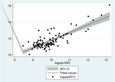
10 12 14 16
8 9 10 11 12 13
logpop1930
95% CI Fitted values logpop2010
[image:12.595.99.498.253.537.2]Notes: Number of observations=97; Regression Fit: logpop2010= 1.99 + 0.98*logpop1930, Adj. R-squared= 0.67.
Figure 1. The persistence of spatial distribution of population
MAIN ESTIMATION RESULTS
12
[image:13.595.66.531.203.579.2]persistence is relatively strong. This means that log population in 1930 explains more than half of the variation in recent population across cities in Java.
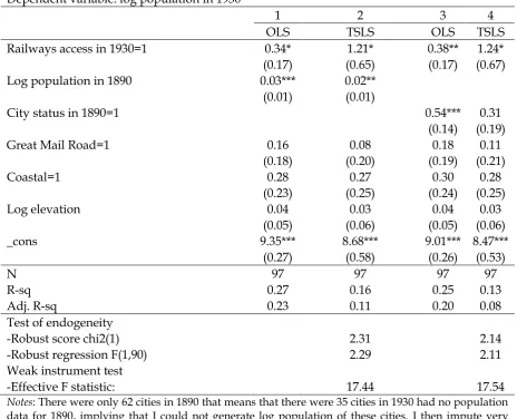
Table 2. The short-run influence of the colonial railways Dependent variable: log population in 1930
1 2 3 4
OLS TSLS OLS TSLS
Railways access in 1930=1 0.34* 1.21* 0.38** 1.24* (0.17) (0.65) (0.17) (0.67) Log population in 1890 0.03*** 0.02**
(0.01) (0.01)
City status in 1890=1 0.54*** 0.31
(0.14) (0.19)
Great Mail Road=1 0.16 0.08 0.18 0.11
(0.18) (0.20) (0.19) (0.21)
Coastal=1 0.28 0.27 0.30 0.28
(0.23) (0.25) (0.24) (0.25)
Log elevation 0.04 0.03 0.04 0.03
(0.05) (0.06) (0.05) (0.06)
_cons 9.35*** 8.68*** 9.01*** 8.47***
(0.27) (0.58) (0.26) (0.53)
N 97 97 97 97
R-sq 0.27 0.16 0.25 0.13
Adj. R-sq 0.23 0.11 0.20 0.08
Test of endogeneity
-Robust score chi2(1) 2.31 2.14
-Robust regression F(1,90) 2.29 2.11
Weak instrument test
-Effective F statistic: 17.44 17.54
Notes: There were only 62 cities in 1890 that means that there were 35 cities in 1930 had no population data for 1890, implying that I could not generate log population of these cities. I then impute very small number for these 35 cities to make them can be transformed into log value (specification1 and -2). But, this implies that the coefficient would be smaller. Alternatively, I simply use a dummy variable for the 62 cities that existed in 1890 (specification-3 and -4). Instrumental variable used in the specification-2 and -4 is a dummy variable for cities that until 1890 did not connect with railways and GreatMail Road. First-stage regressions are not shown. Weak instrument test uses Montiel-Pflueger robust weak instrument test.Robust SEs in parentheses. * p<0.1, ** p<0.05, *** p<0.01.
13
the fact that there was no further railways constructions after 1930, emerges a question whether the railways that were built during the colonial era still influences contemporary population. The rest of this section presents the results of the estimation of the short- and long-term impact of the colonial railways.
Table 2 shows regression results of the short-run impact the colonial railways. Railways access in 1930 gives statistically significant impact on the population in 1930. The magnitudes of this variable increase when I implement the TSLS approach, from 0.34–0.38 to 1.21–1.24. The instrument is relatively strong (F-test = 17). However, endogeneity tests do not reject the null hypothesis that variable RAIL1930 is exogenous, implying that the OLS estimates is consistent. The results suggest that the colonial railways had statistically significant impact on the population in the late colonial era, confirming that the construction of railways provided economic benefits to cities there were connected to the railways.
14
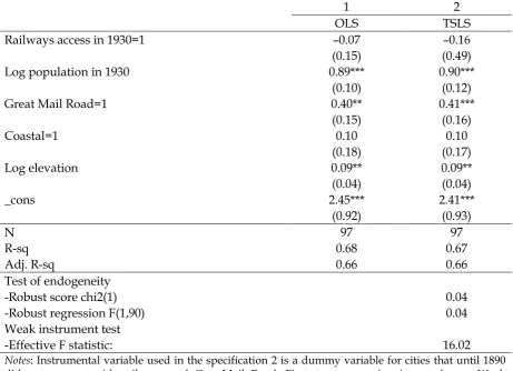
Table 3. The long-run influence of the colonial railways Dependent variable: log population in 2010
1 2
OLS TSLS
Railways access in 1930=1 –0.07 –0.16
(0.15) (0.49)
Log population in 1930 0.89*** 0.90***
(0.10) (0.12)
Great Mail Road=1 0.40** 0.41***
(0.15) (0.16)
Coastal=1 0.10 0.10
(0.18) (0.17)
Log elevation 0.09** 0.09**
(0.04) (0.04)
_cons 2.45*** 2.41***
(0.92) (0.93)
N 97 97
R-sq 0.68 0.67
Adj. R-sq 0.66 0.66
Test of endogeneity
-Robust score chi2(1) 0.04
-Robust regression F(1,90) 0.04
Weak instrument test
-Effective F statistic: 16.02
Notes: Instrumental variable used in the specification 2 is a dummy variable for cities that until 1890 did not connect with railways and GreatMail Road. First-stage regression is not shown. Weak instrument test uses Montiel-Pflueger robust weak instrument test.Robust SEs in parentheses; * p<0.1, ** p<0.05, *** p<0.01.
In contrast with the short-run estimation, Table 3 indicates that the colonial railways lost its advantages in the long-run. The coefficient of railway access in both specifications is statistically insignificant. The same TSLS procedure is applied to estimate specification-2.
15
population (Figure 1). Relation between the results in Table 2 with in Table 3 suggests that the railways basically still had influence since the population in 1930 is influenced by the colonial railways (Table 2) and this pre-independence population has a statitically significant effect on the recent population. But, the advantage of railways tended to decrease.
It is interesting that the Great Mail Road gained its role as one of the important determinants of population distribution. We should interpret this result with caution, as this does not directly mean that colonial road completely rediscovered its function, but it rather indicates that development of road after the independence scattered around the Mail Road as the heart of the cities (see, Nas & Pratiwo 2002). In short, after the colonial era, transportation in Java has been dominated by road transport. Dick (2000) indicated that the competition between road and railways substantially increased in the 1920s. This competition became stronger during the New Order administration. In addition, McCawley (2015) documented that the rail industry had suffered from decades of neglect, by the beginning of the 1970s.
This is also supported by the statistically significant influence of elevation, as an indicator of location fundamentals, on population level in Java. The positive sign of this coefficient can be interpreted that cities in highland area also developed, which is partly explained by the large increase of length of road by more than 4% per year between 1970 and 2013 (McCawley 2015).
16
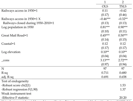
[image:17.595.67.533.319.671.2]0 for the others. This variable then interacts with dummy variable of railways in 1930. I run the same model in Table 3, but now with thisinteraction variable (RAIL1930*RAIL_CLOSED). The result is presented in Table 4, and all variables in Table 3 show the same magnitude. The result in Table 4 suggests that there was a difference in growth pattern between cities that continued to have access to railways, and the others that lost their railways connection. This finding indicates that the colonial railways lost its advantages to cities those lost their railways connection in the post-colonial era.
Table 4. The implication of closing the railways Dependent variable: log population in 2010
1 2
OLS TSLS
Railways access in 1930=1 0.11 –0.42
(0.17) (0.46) Railways access in 1930=1 X –0.46*** –0.32** Railways closed during 1930–2010=1 (0.13) (0.13)
Log population in 1930 0.81*** 0.90***
(0.10) (0.11)
Great Mail Road=1 0.45*** 0.50***
(0.14) (0.15)
Coastal=1 0.12 0.12
(0.17) (0.17)
Log elevation 0.10** 0.10**
(0.04) (0.04)
_cons 3.13*** 2.72***
(0.97) (0.94)
N 97 97
R-sq 0.711 0.680
adj. R-sq 0.691 0.658
Test of endogeneity
-Robust score chi2(1) 1.53
-Robust regression F(1,90) 1.37
Weak instrument test
-Effective F statistic: 20.20
17 PRELIMINARY CONCLUSION
One of the relevant historical backgrounds that might affect the development of spatial distribution of population, and receives concern of new economic history is the practices of
colonial. This study explores the influence of railways, build by the Dutch colonial, on Java’s economic geography using population data at city level. The construction of this railways system can be seen as a historical experiment that may affect the spatial distribution of economic activities in Java.
Employing city data over 100 hundred years, this study finds that the railways had a short-term impact of the spatial distribution of population, but it seems that this colonial investment lost its influence in the long-run. Until 1930, the railways substituted the role of the Great Mail Road, however, in the long-run, between 1930 and 2010, the Great Mail Road
apparently regained its function. Further investigation suggests that the advantages of railways decreased but it still has a long-term impact on the spatial distribution of population, yet locational fundamentals could not be dismissed.
18
Further study needs to address the limitations of this paper. To fully explore the impact of railways it is important to recheck the colonial report, especially Kolonial Verslag, to expand the number of cities regardless the size of their population. It would be usefull to assess the historical reports regarding the earlier proposal to build a railways system in Java. This reports can be used to create better instrumental variable of pseudo railways system in order to conduct other tests.
ACKNOWLEDGEMENT
I acknowledge Gregg Huff for sharing historical dataset on city population in Java (see Huff 2012a, 2012b), and for helpful suggestions; and Michael Grimm for valuable comments.
REFERENCES
Attack, Jeremy, Fred Bateman, Michael Haines, and Robert A. Margo. 2010. ‘Did Railroads Induce or Follow Economic Growth? Urbanization and Population Growth in the American Midwest, 1850–1860’. Social Science History 34(2): 171–197.
Ayuda, Maria I. , Fernando Collantes, and Vicente Pinilla. 2010. ‘From Locational Fundamentals to Increasing Returns: The Spatial Concentration of Population in Spain, 1787–2000. Journal of Geographical Systems 12(1): 25–50
Berger, Thor.,and Kerstin Enflo. 2017. Locomotives of Local Growth: The Short– and Long– term Impact of Railroads in Sweden. Journal of Urban Economics 98(3): 124–138
Cahyono, Artanto R. 2012. ‘Peta Jalur Kereta Api di Jawa-Madura dan Sumatera’ (Map of railways in Java-Madura and Sumatra). Digital Map. Jakarta: Petajalurka.
Dick, Howard. 2000. Representation of Development in 19th and 20th Century Indonesia: A Transport History Perspective. Bulletin of Indonesian Economic Studies 36(1): 185–207. Franch , Xavi, Mateu Morillas-Torné, and Jordi Martí-Henneberg. 2013. Railways as a Factor
of Change in the Distribution of Population in Spain, 1900–1970. Historical Methods: A Journal of Quantitative and Interdisciplinary History 46(3): 144–156
Gallup, John L., Jeffrey D. Sachs, and Andrew A. Mellinger.1999. Geography and Economic Development. International Regional Science Review 22(2): 179–232.
Gatto, Massimo D., and Carlo S. Mastinu. 2017. Geography, Cultural Remoteness and the Second Nature of Within-country Economic Development: Do Island Regions Lag Behind?. Regional Studies (forthcoming).
19
Huff, Gregg. 2012a. ‘Gateway Cities and Urbanisation in Southeast Asia before World War II’. Discussion Papers in Economic and Social History No. 96, University of Oxford, Oxford.
Huff, Gregg. 2012b. Export-led Growth, Gateway Cities and Urban System Development in pre-World War II Southeast Asia. The Journal of Development Studies 48(10): 1431–1452. Jedwab, Remi, and Alexander Moradi. 2016. The Permanent Effects of Transportation
Revolutions in Poor Countries: Evidence from Africa. The Review of Economics and Statistics 98(2): 268–284
Jedwab, Remi, Edward Kerby, and Alexander Moradi. 2017. History, path dependence and development: Evidence from colonial railways, settlers and cities in Kenya. The Economic Journal 1–28
Jenk, Lelland H. 1944. Railroads as an Economic Force in American Development. The Journal of Economic History 4(1): 1–20.
Maloney, William F., and Filipe V. Caicedo. 2015. The Persistence of (Subnational) Fortune. The Economic Journal 126(598): 2363–2401.
McCawley, Peter. 2015. Infrastructure Policy in Indonesia, 1965–2015: A Survey. Bulletin of Indonesian Economic Studies 51(2): 263–285.
Michalopoulos, Stelios., and Elias Papaioannou. 2017. Series Introduction: Historical Legacies and Contemporary Development. In The Long Economic and Political Shadow of History Volume II. Africa and Asia, edited by Stelios Michalopoulos and Elias Papaioannou, vii–xxx. E. London: CEPR Press.
Nas, Peter J.M., and Pratiwo. 2002. Java and De Groote Postweg, La Grande Route, the Great Mail Road, Jalan Raya Pos. Bijdragen tot de Taal-, Land- en Volkenkunde158(4): 707–725. Negara, Siwage D. 2016. Indonesia’s Infrastructure Development under the Jokowi
Administration. Southeast Asian Affair: 145–165.
Nunn, Nathan. 2009. The Importance of History for Economic Development. Annual Review of Economics 1(1):1–28.
Reitsma, S.A. 1925. Gedenkboek der staatspoor- en tramwegen in NederlandscheIndië 1875-1925. Batavia: Weltevreden.
Reitsma, S.A. 1928. Kortegeschiendenis der Nederlandsch-Indische spoor- en tramwagen. Batavia: Weltevreden.
Ricklefs, Merle C. 2001. A History of Modern Indonesia since c.1200. Hampshire: Palgrave. Rogowski, Jon C., John Gerring, Lee Cojocaru, and Matthew Maguire. 2017. Infrastructure
and Development: Evidence from Postal Systems (
http://www.polisci.ucla.edu/sites/default/files/u245/jon_rogowski_paper_02-13-17.pdf)
Roos, Michael W.M. 2005. How Important is Geography for Agglomeration?. Journal of Economic Geography 5(5): 605–620.
Teeuwen, Dirk. 2010. Manpower, Steam Tractions and Contact Wires.