Conservation Objectives Series
National Parks and Wildlife Service
Moyree River System SAC 000057
National Parks and Wildlife Service,
Department of Culture, Heritage and the Gaeltacht,
90 King Street North, Dublin 7, D07 N7CV, Ireland.
Web: www.npws.ie
E-mail: [email protected]
Citation:
ISSN 2009-4086
Series Editor: Rebecca Jeffrey
Introduction
European and national legislation places a collective obligation on Ireland and its citizens
to maintain habitats and species in the Natura 2000 network at favourable conservation
condition. The Government and its agencies are responsible for the implementation and
enforcement of regulations that will ensure the ecological integrity of these sites.
A site-specific conservation objective aims to define favourable conservation condition for
a particular habitat or species at that site.
Favourable conservation status of a habitat is achieved when:
• its natural range, and area it covers within that range, are stable or increasing, and
• the specific structure and functions which are necessary for its long-term maintenance
exist and are likely to continue to exist for the foreseeable future, and
• the conservation status of its typical species is favourable.
The favourable conservation status of a species is achieved when:
• population dynamics data on the species concerned indicate that it is maintaining itself
on a long-term basis as a viable component of its natural habitats, and
• the natural range of the species is neither being reduced nor is likely to be reduced for
the foreseeable future, and
• there is, and will probably continue to be, a sufficiently large habitat to maintain its
populations on a long-term basis.
The overall aim of the Habitats Directive is to maintain or restore the favourable
conservation status of habitats and species of community interest. These habitats and
species are listed in the Habitats and Birds Directives and Special Areas of Conservation
and Special Protection Areas are designated to afford protection to the most vulnerable
of them. These two designations are collectively known as the Natura 2000 network.
The maintenance of habitats and species within Natura 2000 sites at favourable
conservation condition will contribute to the overall maintenance of favourable
conservation status of those habitats and species at a national level.
1. The targets given in these conservation objectives are based on best available
information at the time of writing. As more information becomes available, targets for
attributes may change. These will be updated periodically, as necessary.
2. An appropriate assessment based on these conservation objectives will remain valid
even if the targets are subsequently updated, providing they were the most recent
objectives available when the assessment was carried out. It is essential that the date and
version are included when objectives are cited.
3. Assessments cannot consider an attribute in isolation from the others listed for that
habitat or species, or for other habitats and species listed for that site. A plan or project
with an apparently small impact on one attribute may have a significant impact on
another.
4. Please note that the maps included in this document do not necessarily show the
entire extent of the habitats and species for which the site is listed. This should be borne
in mind when appropriate assessments are being carried out.
5. When using these objectives, it is essential that the relevant backing/supporting
documents are consulted, particularly where instructed in the targets or notes for a
particular attribute.
Qualifying Interests
Moyree River System SAC
* indicates a priority habitat under the Habitats Directive000057
1303
Lesser Horseshoe Bat Rhinolophus hipposideros
1355
Otter Lutra lutra
3260
Water courses of plain to montane levels with the Ranunculion fluitantis and
Callitricho-Batrachion vegetation
7230
Alkaline fens
8240
Limestone pavements
Supporting documents, relevant reports & publications
Supporting documents, NPWS reports and publications are available for download from: www.npws.ie/Publications
Year : 1987
Title : The vegetation of Irish rivers
Author : Heuff, H.
Series : Unpublished report to NPWS
Year : 2006
Title : Otter survey of Ireland 2004/2005
Author : Bailey, M.; Rochford, J.
Series : Irish Wildlife Manual No. 23
Year : 2007
Title : Supporting documentation for the Habitats Directive Conservation Status Assessment - backing documents. Article 17 forms and supporting maps
Author : NPWS
Series : Unpublished report to NPWS
Year : 2012
Title : Ireland Red List No. 8: Bryophytes
Author : Lockhart, N.; Hodgetts, N.; Holyoak, D.
Series : Ireland Red List series, NPWS
Year : 2013
Title : National otter survey of Ireland 2010/12
Author : Reid, N.; Hayden, B.; Lundy, M.G.; Pietravalle, S.; McDonald, R.A.; Montgomery, W.I.
Series : Irish Wildlife Manual No. 76
Year : 2013
Title : National survey of limestone pavement and associated habitats in Ireland
Author : Wilson, S.; Fernandez, F.
Series : Irish Wildlife Manual No. 73
Year : 2013
Title : The status of EU protected habitats and species in Ireland. Volume 2. Habitats assessments
Author : NPWS
Series : Conservation assessments
Year : 2013
Title : Conservation status assessments for three fen habitat types - 7230, 7210 and 7140
Author : Kimberley, S.
Series : Unpublished report to NPWS
Year : 2014
Title : Guidelines for a national survey and conservation assessment of upland vegetation and habitats in Ireland, Version 2.0
Author : Perrin, P.M.; Barron, S.J.; Roche, J.R.; O’Hanrahan, B.
Series : Irish Wildlife Manual No. 79
Year : 2016
Title : Ireland Red List No. 10: Vascular Plants
Author : Wyse Jackson, M.; FitzPatrick, Ú.; Cole, E.; Jebb, M.; McFerran, D.; Sheehy Skeffington, M.; Wright, M.
Year : 1982
Title : Otter survey of Ireland
Author : Chapman, P.J.; Chapman, L.L.
Series : Unpublished report to Vincent Wildlife Trust
Year : 1991
Title : The spatial organization of otters (Lutra lutra) in Shetland
Author : Kruuk, H.; Moorhouse, A.
Series : Journal of Zoology, 224: 41-57
Year : 2003
Title : Ecology of watercourses characterised by Ranunculion fluitantis and Callitricho-Batrachion vegetation
Author : Hatton-Ellis, T.W.; Grieve, N.
Series : Conserving Natura 2000 Rivers Ecology Series No. 11. English Nature, Peterborough
Year : 2004
Title : Common Standards Monitoring guidance for lowland wetland habitats
Author : JNCC
Series : Joint Nature Conservation Committee, Peterborough
Year : 2006
Title : Otters - ecology, behaviour and conservation
Author : Kruuk, H.
Series : Oxford University Press
Year : 2007
Title : Protecting and managing underground sites for bats
Author : Mitchell-Jones, A.J.; Bihari, Z.; Masing, M.; Rodrigues, L.
Series : EUROBATS Publication Series No. 2
Year : 2008
Title : The lesser horseshoe bat conservation handbook
Author : Schofield, H.W.
Series : The Vincent Wildlife Trust
Year : 2009
Title : Importance of night roosts for bat conservation: roosting behaviour of the lesser horseshoe bat Rhinolophus hipposideros
Author : Knight, T.; Jones, G.
Series : Endangered Species Research, 8: 79-86
Year : 2010
Title : Otter tracking study of Roaringwater Bay
Author : De Jongh, A.; O'Neill, L.
Series : Unpublished draft report to NPWS
Year : 2018
Title : Conservation objectives supporting document – lesser horseshoe bat (Rhinolophus hipposideros)
Author : NPWS
Series : Conservation objectives supporting document
Year : 2011
Title : Review and revision of empirical critical loads and dose-response relationships. Proceedings of an expert workshop, Noordwijkerhout, 23-25 June 2010
Author : Bobbink, R.; Hettelingh, J.P.
Series : RIVM report 680359002, Coordination Centre for Effects, National Institute for Public Health and the Environment (RIVM)
Year : 2013
Title : Management strategies for the protection of high status water bodies
Author : Ní Chatháin, B.; Moorkens, E.; Irvine, K.
Series : Strive Report Series No. 99. EPA, Wexford
Year : 2013
Title : Interpretation manual of European Union habitats- Eur 28
Author : European Commission- DG Environment
Series : European Commission
Year : 2016
Title : A narrative for conserving freshwater and wetland habitats in England
Author : Mainstone, C.; Hall, R.; Diack, I.
Series : Natural England Research Reports Number 064
Year : 2017
Title : Water Quality in Ireland 2010-2015
Author : Fanning, A.; Craig, M.; Webster, P.; Bradley, C.; Tierney, D.; Wilkes, R.; Mannix, A.; Treacy, P.; Kelly, F.; Geoghegan, R.; Kent, T.; Mageean, M.
Spatial data sources
Year : 2013
Title : National Survey of Limestone Pavement and Associated Habitats in Ireland distribution data
GIS Operations : Dataset clipped to the SAC boundary Expert opinion used as necessary to resolve any issues arising
Used For : 8240 (map 2)
Year : 2018
Title : NPWS lesser horseshoe bat database
GIS Operations : Roost identified, clipped to SAC boundary. Expert opinion used as necessary to resolve any issues arising
Used For : 8310, 1303 (map 3)
Year : 2007
Title : Forest Inventory and Planning System (FIPS)
GIS Operations : Dataset clipped to 2.5km buffer centred on roost location
Conservation Objectives for : Moyree River System SAC [000057]
3260
Water courses of plain to montane levels with the Ranunculion fluitantis
and Callitricho-Batrachion vegetation
To maintain the favourable conservation condition of Water courses of plain to montane
levels with the Ranunculion fluitantis and Callitricho-Batrachion vegetation in Moyree River
System SAC, which is defined by the following list of attributes and targets:
Attribute
Measure
Target
Notes
Habitat area Kilometres Area stable or increasing, subject to natural processes
Conservation objectives concentrate on the high conservation value sub-types of habitat 3260. Selection of Moyree River System SAC used a broad interpretation and the habitat's full distribution and sub-types in the SAC are not yet documented. The Moyree River system is a tributary of the River Fergus. The rivers in the SAC are slow-flowing and meandering, and disappear underground in the south-west of the SAC. Heuff (1987) surveyed a 500m stretch of Moyree River
Habitat distribution
Occurrence No decline, subject to natural processes
Further study of Irish rivers is needed to interpret the broad description of habitat 3260 which covers from upland bryophyte/macroalgal-dominated to lowland depositing rivers with pondweeds and starworts (European Commission, 2013). The low-lying Moyree River valley is sheltered on the east by limestone outcrops and woodland, and to the west by low drumlins. The river flows in a south-westerly direction, through a series of pools and meanders, and has eroding and accreting banks. There is an extensive floodplain, dominated by wet grassland and marsh on alluvial soil in the north-east and by black bog-rush (Schoenus nigricans) and some great fen-sedge (Cladium mariscus) fen on peat and marl as it moves downstream. The stream is particularly important for its fringing floating scraw. Heuff (1987) recorded abundant yellow water-lily (Nuphar lutea), bogbean (Menyanthes trifoliata) and common duckweed (Lemna minor) in the river Hydrological
regime: river flow
Metres per second Maintain appropriate hydrological regimes
High conservation value sub-types are associated with natural hydrological regimes. A natural flow regime is required for both plant communities and channel geomorphology to be in favourable condition, exhibiting typical dynamics for the river type (Hatton-Ellis and Grieve, 2003). For many sub-types, high flows are required to maintain the substratum necessary for the characteristic species; however, as noted, the Moyree River system is slow-flowing, depositing and karstic. The Moyree River system has an extensive natural floodplain and significant groundwater connections. Frequent drainage ditches have also been recorded (NPWS internal files). Heuff (1987) surveyed a 500m stretch of 0.3m-2m depth (average 1.5m) with pool areas and meanders
Hydrological regime: groundwater discharge
Metres per second Maintain appropriate hydrological regime
Even small groundwater contributions can
Substratum composition: particle size range
Millimetres Maintain appropriate substratum particle size range, quantity and quality, subject to natural processes
Although many of the high conservation value sub-types are dominated by coarse substrata and bedrock, certain sub-types, notably those associated with lake inflows/outflows and peatlands, are dominated by fine substrata. The size and distribution of particles is largely determined by the river flow and geology. The chemical composition (particularly minerals and nutrients) of the substratum is also important. The quality of finer sediment particles is a notable driver of rooted plant communities. Heuff (1987) found silt (80% cover) and peat (20%) were the dominant substrata in the Moyree River survey stretch
Water quality Various Maintain/restore appropriate water quality to support the natural structure and functioning of the habitat and its sub-types
The specific targets may vary among sub-types. The rivers within Moyree River System SAC are likely to be naturally base-rich, but nutrient-poor, and to require Water Framework Directive (WFD) high status in terms of nutrient and oxygenation standards. WFD macroinvertebrate and phytobenthos metrics (and associated Ecological Quality Ratios (EQRs)) are unlikely to be useful indicators, as they are designed for use in faster flows. Exceptionally clear water in the SAC has been noted (NPWS internal files). Agricultural use (fertilisation, re-seeding, etc.) in the topographic and groundwater catchments may have increased nutrient loads to the Moyree River system. See also The European Communities Environmental Objectives (Surface Waters) Regulations 2009, Environmental Protection Agency (EPA) river water quality reports (e.g. Fanning et al., 2017) and Ní Chatháin et al. (2013)
Typical species Occurrence Maintain typical species of the relevant habitat sub-types in good condition, including appropriate distribution and abundance
Typical species have not been fully defined but may include higher plants, bryophytes, algae and invertebrates. Heuff (1987) found Nuphar lutea, Lemna minor and Menyanthes trifoliata to be the dominant species in her survey stretch and recorded an important fringing floating scraw vegetation. Where flow is faster, Berula erecta, Sparganium erectum and Epilobium sp. occur and the river is often fringed by emergent vegetation of Carex rostrata, Phragmites australis, Schoenoplectus lacustris and Juncus sp., while fen along the river has Schoenus nigricans, Carex nigra, Cladium mariscus, Typha and other species (NPWS internal files). Drainage ditches have a similar flora to the river, plus Equisetum fluviatile, Mentha sp., Apium nodiflorum, Iris pseudacorus and Carex spp. Species in the wet grassland/marsh mosaic include Caltha palustris, Comarum palustre, Carex nigra and Mentha sp.
Floodplain connectivity: area
Hectares The area of active floodplain at and upstream of the habitat should be maintained to support the typical species and vegetation composition of the habitat and its sub-types
River connectivity with the floodplain is important for the functioning of this habitat. Channels with a naturally functioning floodplain are better able to maintain habitat and water quality (Hatton-Ellis and Grieve, 2003). Floodplain connectivity is particularly important in terms of sediment sorting and nutrient deposition. High conservation value rivers are intimately connected to floodplain habitats and function as important wildlife corridors, connecting otherwise isolated or fragmented habitats in the wider countryside (Hatton-Ellis and Grieve, 2003; Mainstone et al., 2016). Heuff (1987) stated that the Moyree River system was of considerable
Riparian habitat: area
Hectares Maintain the area and condition of fringing habitats necessary to support the habitat and its sub-types
Riparian habitats (including along lakes) are integral to the structure and functioning of rivers, even where not part of a floodplain. Fringing habitats can contribute to the aquatic food web (e.g.
Conservation Objectives for : Moyree River System SAC [000057]
7230
Alkaline fens
To maintain the favourable conservation condition of Alkaline fens in Moyree River System
SAC, which is defined by the following list of attributes and targets:
Attribute
Measure
Target
Notes
Habitat area Hectares Area stable or increasing, subject to natural processes
Alkaline fen has not been mapped in detail for Moyree River System SAC and thus the total area of the qualifying habitat in the SAC is unknown. Areas of alkaline fen occur in low-lying areas close to the Moyree River within the floodplain of the river. The habitat occurs in association with other wetland habitats, wet grassland, scrub and limestone pavements (8240) (NPWS internal files) Habitat
distribution
Occurrence No decline, subject to natural processes
See the notes for Habitat area above Ecosystem
function: soil nutrients
Soil pH and appropriate nutrient levels at a representative number of monitoring stops
Maintain soil pH and nutrient status within natural ranges
Relevant nutrients and their natural ranges are yet to be defined. However, nitrogen deposition is noted as being relevant to this habitat in NPWS (2013). See also Bobbink and Hettelingh (2011)
Ecosystem function: peat formation
Percentage cover of peat-forming vegetation and water table levels
Maintain active peat formation, where appropriate
In order for peat to form, water levels need to be slightly below or above the soil surface for c.90% of the time Ecosystem function: hydrology - groundwater levels Water levels (centimetres); duration of levels; hydraulic gradients
Maintain, or where necessary restore, appropriate natural hydrological regimes necessary to support the natural structure and functioning of the habitat
Fen habitats require high groundwater levels (i.e. water levels at or above the ground surface) for a large proportion of the calendar year (i.e. duration of mean groundwater level). Fen groundwater levels are controlled by regional groundwater levels in the contributing catchment area (which sustain the hydraulic gradients of the fen groundwater table). Regional abstraction of groundwater may affect fen groundwater levels. In this SAC, water levels in the fen should fluctuate according to the state of Moyree River (NPWS internal files)
Ecosystem function: hydrology - surface water flow
Drain density and form Maintain, or where necessary restore, as close as possible to natural or semi-natural drainage conditions
Drainage, either within or surrounding the fen habitat, can result in the drawdown of the alkaline fen groundwater table. The depth, geometry and density of drainage (hydromorphology) will indicate the scale and impact on fen hydrology. Drainage can result in loss of characteristic species and transition to drier habitats. In this SAC, some areas of the fen are dissected by old, infilling drains (NPWS internal files) Ecosystem function: water quality Water chemistry measures
Maintain appropriate water quality, particularly pH and nutrient levels, to support the natural structure and functioning of the habitat
Fens receive natural levels of nutrients (e.g. iron, magnesium and calcium) from water sources. However, they are generally poor in nitrogen and phosphorus, with the latter tending to be the limiting nutrient under natural conditions. Water supply should also be relatively calcium-rich
Community diversity
Abundance of variety of vegetation communities
Maintain variety of vegetation communities, subject to natural processes
The entire diversity of alkaline fen vegetation communities present in the SAC is currently unknown. Information on the vegetation communities associated with alkaline fens in the uplands is presented in Perrin et al. (2014) Vegetation
composition: brown mosses
Percentage cover at a representative number of 2m x 2m monitoring stops
Maintain adequate cover of typical brown moss species
Vegetation composition: typical vascular plants
Percentage cover at a representative number of 2m x 2m monitoring stops
Maintain adequate cover of typical vascular plant species
For lists of typical plant species, see the Article 17 conservation status assessment for alkaline fens (NPWS, 2013) and the fen habitats supporting document (Kimberley, 2013). See also Perrin et al. (2014) and JNCC (2004). Typical vascular plants recorded in the habitat in the SAC include black bog-rush (Schoenus nigricans), common sedge (Carex nigra), purple moor-grass (Molinia caerulea), marsh bedstraw (Galium palustre), water mint (Mentha aquatica), devil's-bit scabious (Succisa pratensis) and common butterwort (Pinguicula vulgaris) (NPWS internal files)
Vegetation composition: native negative indicator species
Percentage cover at a representative number of 2m x 2m monitoring stops
Cover of native negative indicator species at insignificant levels
Negative indicators include species not characteristic of the habitat and species indicative of undesirable impacts such as overgrazing, undergrazing, nutrient enrichment, agricultural improvement or impacts on hydrology. Native negative indicators may include graminoids such as reed canary-grass (Phalaris arundinacea) and reed sweet-grass (Glyceria maxima), tall herbs such as great willowherb (Epilobium hirsutum), bracken (Pteridium aquilinum), bramble (Rubus fruticosus) and common nettle (Urtica dioica), and bryophytes such as Brachythecium rutabulum and Kindbergia praelonga
Vegetation composition: non-native species
Percentage cover at, and in local vicinity of, a representative number of 2m x 2m monitoring stops
Cover of non-native species less than 1%
Attribute and target based on Perrin et al. (2014). Non-native species can be invasive and have deleterious effects on native vegetation. A low target is set as non-native species can spread rapidly and are most easily dealt with when still at lower abundances
Vegetation composition: native trees and shrubs
Percentage cover in local vicinity of a representative number of monitoring stops
Cover of scattered native trees and shrubs less than 10%
Attribute and target based on Perrin et al. (2014). Scrub and trees will tend to invade if fen conditions become drier
Vegetation composition: soft rush and common reed cover
Percentage cover in local vicinity of a representative number of monitoring stops
Total cover of soft rush (Juncus effusus) and common reed (Phragmites australis) less than 10%
Attribute and target based on Perrin et al. (2014)
Vegetation structure: litter
Percentage cover in local vicinity of a representative number of monitoring stops
Total cover of litter not more than 25%
Attribute and target based on JNCC (2004). More than 25% litter cover may indicate insufficient removal of biomass by grazing and/or undesirable water table levels
Physical structure: disturbed bare ground
Percentage cover at, and in local vicinity of, a representative number of 2m x 2m monitoring stops
Cover of disturbed bare ground not more than 10%
Attribute and target based on Perrin et al. (2014). While grazing may be appropriate in this habitat, excessive areas of disturbed bare ground may develop due to unsuitable grazing regimes. Disturbance can include hoof marks, wallows, human footprints, vehicle and machinery tracks. Excessive disturbance can result in loss of characteristic species and presage erosion for peatlands
Physical structure: tufa formations
Percentage cover in local vicinity of a representative number of monitoring stops
Disturbed proportion of vegetation cover where tufa is present is less than 1%
Attribute and target based on Perrin et al. (2014)
Indicators of local distinctiveness
Occurrence and population size
No decline in distribution or population sizes of rare, threatened or scarce species associated with the habitat; maintain features of local distinctiveness, subject to natural processes
Conservation Objectives for : Moyree River System SAC [000057]
8240
Limestone pavements
To maintain the favourable conservation condition of Limestone pavements* in Moyree
River System SAC, which is defined by the following list of attributes and targets:
Attribute
Measure
Target
Notes
Habitat area Hectares Area stable or increasing, subject to natural processes
Limestone pavement* covers extensive areas of Moyree River System SAC and occurs in intimate association with other habitats in the SAC: calcareous grasslands, juniper scrub and dry heath. Therefore, these habitats cannot easily be mapped or considered separately. Wilson and Fernandez (2013) mapped the indicative area of limestone pavement, including mosaics with other habitats, as 154.36ha (see map 2). One sub-site (Clooneen, site code NSLP18) associated with the SAC was surveyed in detail as part of the National Survey of Limestone Pavement and Associated Habitats (Wilson and Fernandez, 2013). This survey should be consulted for further details
Habitat distribution
Occurrence No decline. Map 2 shows indicative distribution, including mosaics with other habitats
See the notes for Habitat area above. Distribution based on data from Wilson and Fernandez (2013). This habitat can be split into exposed pavement and wooded pavement. The majority of the limestone pavement in Moyree River System SAC is exposed pavement. In some places, particularly in the north of the SAC, hazel (Corylus avellana) scrub is well-developed. In other areas, particularly in the south-west of the SAC, hazel/ash (Fraxinus excelsior) woodland occurs (NPWS internal files)
Vegetation composition: typical species
Number at a
representative number of monitoring stops
At least seven positive indicator species present
Positive indicator species for exposed and wooded pavement are listed in Wilson and Fernandez (2013). Positive indicator species recorded by Wilson and Fernandez (2013) on exposed pavement in the SAC include squinancywort (Asperula cynanchica), bloody crane's-bill (Geranium sanguineum), herb-robert (G. herb-robertianum), ivy (Hedera helix), wall lettuce (Mycelis muralis), burnet rose (Rosa spinosissima), blue moor-grass (Sesleria caerulea), wood sage (Teucrium scorodonia), wild thyme (Thymus polytrichus), maidenhair spleenwort (Asplenium trichomanes), rustyback fern (A. ceterach), soft shield-fern (Polystichum setiferum) and the bryophytes Breutelia chrysocoma, Conocephalum conicum, Ctenidium molluscum, Fissidens dubius, Neckera crispa and Tortella tortuosa
Vegetation composition: bryophyte layer
Percentage at a representative number of monitoring stops
Bryophyte cover at least 50% on wooded pavement
Attribute and target based on Wilson and Fernandez (2013)
Vegetation composition: negative indicator species
Percentage at a representative number of monitoring stops
Collective cover of negative indicator species on exposed pavement not more than 1%
Negative indicator species are listed in Wilson and Fernandez (2013). Negative indicator species for wooded pavement overlap with non-native species (below). The negative indicator species bramble (Rubus fruticosus agg.) was recorded by Wilson and Fernandez (2013) in one monitoring stop on exposed pavement in the Clooneen sub-site in the SAC
Vegetation composition: non-native species
Percentage at a representative number of monitoring stops
Cover of non-native species not more than 1% on exposed pavement; on wooded pavement not more than 10% with no regeneration
Attribute and target based on Wilson and Fernandez (2013). The non-native invasive species cotoneaster (Cotoneaster sp.) and wild clematis (Clematis vitalba) were recorded in the Clooneen sub-site by Wilson and Fernandez (2013)
Vegetation composition:
Percentage at a representative number
Scrub cover no more than 25% of exposed pavement
Vegetation composition: bracken cover
Percentage at a representative number of monitoring stops
Bracken (Pteridium aquilinum) cover no more than 10% on exposed pavement
Attribute and target based on Wilson and Fernandez (2013)
Vegetation structure: woodland canopy
Percentage at a representative number of monitoring stops
Canopy cover on wooded pavement at least 30%
Attribute and target based on Wilson and Fernandez (2013)
Vegetation structure: dead wood
Occurrence in a representative number of monitoring stops
Sufficient quantity of dead wood on wooded pavement to provide habitat for saproxylic organisms
Dead wood is a valuable resource and an integral part of a healthy, functioning woodland ecosystem
Physical structure: disturbance
Occurrence in a representative number of monitoring stops
No evidence of grazing pressure on wooded pavement
Attribute and target based on Wilson and Fernandez (2013)
Indicators of local distinctiveness
Occurrence Indicators of local distinctiveness are maintained
Conservation Objectives for : Moyree River System SAC [000057]
8310
Caves not open to the public
Caves not open to the public (8310) is integrally linked to lesser horseshoe bat
(Rhinolophus hipposideros) (1303) as part of the habitat for the species; therefore, a
separate conservation objective has not been set for the habitat in Moyree River System
SAC. See map 3. See the conservation objectives supporting document for lesser horseshoe
bat (NPWS, 2018) for further details
Conservation Objectives for : Moyree River System SAC [000057]
1303
Lesser Horseshoe Bat Rhinolophus hipposideros
To maintain the favourable conservation condition of Lesser Horseshoe Bat in Moyree River
System SAC, which is defined by the following list of attributes and targets:
Attribute
Measure
Target
Notes
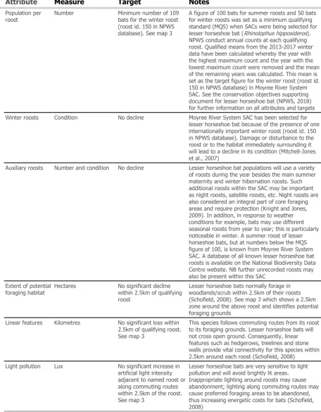
Population per roost
Number Minimum number of 109 bats for the winter roost (roost id. 150 in NPWS database). See map 3
A figure of 100 bats for summer roosts and 50 bats for winter roosts was set as a minimum qualifying standard (MQS) when SACs were being selected for lesser horseshoe bat (Rhinolophus hipposideros). NPWS conduct annual counts at each qualifying roost. Qualified means from the 2013-2017 winter data have been calculated whereby the year with the highest maximum count and the year with the lowest maximum count were removed and the mean of the remaining years was calculated. This mean is set as the target figure for the winter roost (roost id. 150 in NPWS database) in Moyree River System SAC. See the conservation objectives supporting document for lesser horseshoe bat (NPWS, 2018) for further information on all attributes and targets Winter roosts Condition No decline Moyree River System SAC has been selected for
lesser horseshoe bat because of the presence of one internationally important winter roost (roost id. 150 in NPWS database). Damage or disturbance to the roost or to the habitat immediately surrounding it will lead to a decline in its condition (Mitchell-Jones et al., 2007)
[image:17.595.64.521.125.711.2]Auxiliary roosts Number and condition No decline Lesser horseshoe bat populations will use a variety of roosts during the year besides the main summer maternity and winter hibernation roosts. Such additional roosts within the SAC may be important as night roosts, satellite roosts, etc. Night roosts are also considered an integral part of core foraging areas and require protection (Knight and Jones, 2009). In addition, in response to weather conditions for example, bats may use different seasonal roosts from year to year; this is particularly noticeable in winter. A summer roost of lesser horseshoe bats, but at numbers below the MQS figure of 100, is known from Moyree River System SAC. A database of all known lesser horseshoe bat roosts is available on the National Biodiversity Data Centre website. NB further unrecorded roosts may also be present within this SAC
Extent of potential foraging habitat
Hectares No significant decline within 2.5km of qualifying roost
Lesser horseshoe bats normally forage in woodlands/scrub within 2.5km of their roosts (Schofield, 2008). See map 3 which shows a 2.5km zone around the above roost and identifies potential foraging grounds
Linear features Kilometres No significant loss within 2.5km of qualifying roost. See map 3
This species follows commuting routes from its roost to its foraging grounds. Lesser horseshoe bats will not cross open ground. Consequently, linear features such as hedgerows, treelines and stone walls provide vital connectivity for this species within 2.5km around each roost (Schofield, 2008)
Light pollution Lux No significant increase in artificial light intensity adjacent to named roost or along commuting routes within 2.5km of the roost. See map 3
Conservation Objectives for : Moyree River System SAC [000057]
1355
Otter Lutra lutra
To maintain the favourable conservation condition of Otter in Moyree River System SAC,
which is defined by the following list of attributes and targets:
Attribute
Measure
Target
Notes
Distribution Percentage positive survey sites
No significant decline Measure based on standard otter survey technique. Favourable Conservation Status (FCS) target, based on 1980/81 survey findings, is 88% in SACs. Current range is estimated at 93.6% (Reid et al., 2013) Extent of
terrestrial habitat
Hectares No significant decline. Area mapped and calculated as 20.1ha
No field survey. Areas mapped to include 10m terrestrial buffer along shorelines and river banks identified as critical for otters (NPWS, 2007) Extent of
freshwater (river) habitat
Kilometres No significant decline. Length mapped and calculated as 10.0km
No field survey. River length calculated on the basis that otters will utilise freshwater habitats from estuary to headwaters (Chapman and Chapman, 1982)
Extent of freshwater (lake) habitat
Hectares No significant decline. Area mapped and calculated as 0.5ha
No field survey. Area mapped based on evidence that otters tend to forage within 80m of the shoreline (NPWS, 2007)
Couching sites and holts
Number No significant decline Otters need lying up areas throughout their territory where they are secure from disturbance (Kruuk and Moorhouse, 1991; Kruuk, 2006)
Fish biomass available
Kilograms No significant decline Broad diet that varies locally and seasonally, but dominated by fish, in particular salmonids, eels and sticklebacks in freshwater (Bailey and Rochford, 2006; Reid et al., 2013)
Barriers to connectivity
© Ordnance Survey Ireland
MAP 1:
MOYREE RIVER SYSTEM SAC CONSERVATION OBJECTIVES
The mapped boundaries are of an indicative and general nature only. Boundaries of designated areas are subject to revision.
Ordnance Survey of Ireland Licence No EN 0059216. © Ordnance Survey of Ireland Government of Ireland
±
SITE CODE:
SAC 000057; version 3. CO. CLARE
L
e
g
e
n
d
M
o
yre
e
R
ive
r S
yste
m
S
A
C
0
0
0
0
5
7
Boston
Killinaboy
G
ort
Corrofin
C
O
. CLA
RE
C
O
. G
A
LW
A
Y
MAP 2:
±
SITE CODE:
L
e
g
e
n
d
MAP 3:
MOYREE RIVER SYSTEM SAC CONSERVATION OBJECTIVES
The mapped boundaries are of an indicative and general nature only. Boundaries of designated areas are subject to revision.
Ordnance Survey of Ireland Licence No EN 0059216. © Ordnance Survey of Ireland Government of Ireland
±
SITE CODE:
SAC 000057; version 3.0. CO. CLARE
L
e
g
e
n
d
OSi Discovery Series County Boundary Moyree River System SAC 000057 8310 Caves not open to the public
1303 Lesser Horseshoe Bat Rhinolophus hipposideros Roost Location