GIS-BASED DIGITAL SOIL MAP FOR GULLY EROSION MANAGEMENT IN ANAMBRA,
*Nkwunonwo Ugonna Chimnonyerem
Department of Geoinformatics and
ARTICLE INFO ABSTRACT
Digital soil maps offer solutions to several environmental issues, for example; gully erosion hazard, and The availability and production of such maps have been fundamental to recent advances in GIS and other related technologies. This paper describes the production of a digital soil map for Anambra, south eastern Nigeria, using GIS technology. Shee
spatially referenced to WGS 1984 coordinate system. In a GIS, these images were subset, mosaicked and vectorized on
slope, topography, and soil pH
simplify extraction of soil information to users of the digital soil map. Other soil the The results of the study tend to show that the soil distribution of the stud
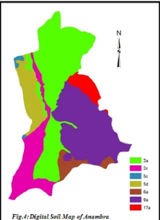
mapping units (2a, 2c, 5c, 5d, 6a, 9a and 17a), occupying about 37.38%, 14.60%, 1.05%, 8.84%, 3.99%, 27.81% and 4.35% of the area respectively. Mapping units 2a and 9a appear to be dominant in the area and their characteristics seem to substantially contribute to the phenomenal gully erosion in the area
Copyright © Nkwunonwo Ugonna Chimnonyerem. This is an op
unrestricted use, distribution, and reproduction in any medium, provided the original work is properly cited.
INTRODUCTION
Soil is a valuable natural resource, which provides the basis of human existence. Plants depend on it for survival, as it provides physical support and nutrients. Housing, industrialization, economic activities, mining, fishery, transportation and all activities that constitute the circle of life such as procreation and extinction, including adverse environmental events one way or the other relate to it. Knowledge about soil plays a significant role in its utilization and management and can be said to involve describing it and providing information about it (Nkwunonwo and Okeke, 2013). Traditionally, describing the soil often starts with measurements and analysis by experts. Information such drainage, ecology, mapping units, classification type, texture, pH values, unique locations, landscape, possible uses and other characteristics particular to a soil distribution is usually provided and represented as spatial features in maps and other supporting documents by a qualitative method. Although, several soil maps have been produced using this qualitative approach, (for example FDALR, 1990) which have assisted in providing adequate data to support several agroprojects, the accuracy and reliability of supporting data remains questionable. The methodology has bee considered to be slow, time consuming and expensive (Lark, 2007) and the resulting soil maps often suffer from dimensional instability and geometric distortion (Okeke and Nkwunonwo, 2007) and tend not to be suitable for quantitative purposes (Zhu et al.
with the increasing need for quick, quantitative, up
resolution and more accurate soil data which seems to overwhelm the qualitative soil maps, research for digital soil maps and soil database is increasingly becoming more attractive.
Gully erosion hazard in Anambra, south eastern Nigeria has been active over the years, and has defeated much control measures put in place by the Nigerian government, local communities and interested groups (Obiadi et al., 2011). Geoscientists and other environmental
*Corresponding author: Nkwunonwo Ugonna Chimnonyerem, of Geoinformatics and Surveying, University of Nigeria Enugu Campus.
ISSN: 0975-833X
Article History:
Received 28th June, 2013
Received in revised form 07th July, 2013
Accepted 30th August, 2013
Published online 14th September, 2013
Key words:
Digital Soil map, Gully erosion, GIS, Soil Database, and Soil mapping Units, Thematic maps and Query.
RESEARCH ARTICLE
BASED DIGITAL SOIL MAP FOR GULLY EROSION MANAGEMENT IN ANAMBRA,
SOUTH EASTERN NIGERIA
Nkwunonwo Ugonna Chimnonyerem
Department of Geoinformatics and Surveying, University of Nigeria Enugu Campus
ABSTRACT
Digital soil maps offer solutions to several environmental issues, for example; gully erosion hazard, and The availability and production of such maps have been fundamental to recent advances in GIS and other related technologies. This paper describes the production of a digital soil map for Anambra, south eastern Nigeria, using GIS technology. Sheets 7 and 8 of hardcopy soil map of Nigeria each at a scale of 1: 650,000 were scanned and spatially referenced to WGS 1984 coordinate system. In a GIS, these images were subset, mosaicked and vectorized on-screen. A non-spatial database was created, by means of
slope, topography, and soil pH values, and linked to the vectorized data. Queries were built into the database, to simplify extraction of soil information to users of the digital soil map. Other soil the
The results of the study tend to show that the soil distribution of the study
mapping units (2a, 2c, 5c, 5d, 6a, 9a and 17a), occupying about 37.38%, 14.60%, 1.05%, 8.84%, 3.99%, 27.81% nd 4.35% of the area respectively. Mapping units 2a and 9a appear to be dominant in the area and their characteristics seem to substantially contribute to the phenomenal gully erosion in the area
This is an open access article distributed under the Creative Commons Attribution License, which permits unrestricted use, distribution, and reproduction in any medium, provided the original work is properly cited.
Soil is a valuable natural resource, which provides the basis of human existence. Plants depend on it for survival, as it provides physical support and nutrients. Housing, industrialization, economic activities, vities that constitute the circle of life such as procreation and extinction, including adverse environmental events one way or the other relate to it. Knowledge about soil plays a significant role in its utilization and management ve describing it and providing information about it (Nkwunonwo and Okeke, 2013). Traditionally, describing the soil often starts with measurements and analysis by experts. Information such drainage, ecology, mapping units, classification values, unique locations, landscape, possible uses and other characteristics particular to a soil distribution is usually provided and represented as spatial features in maps and other supporting documents by a qualitative method. Although, several soil ps have been produced using this qualitative approach, (for assisted in providing adequate data to support several agroprojects, the accuracy and reliability of supporting data remains questionable. The methodology has been considered to be slow, time consuming and expensive (Lark, 2007) and the resulting soil maps often suffer from dimensional instability and geometric distortion (Okeke and Nkwunonwo, 2007) and tend not
et al., 1997). Moreover,
with the increasing need for quick, quantitative, up-to-date, high resolution and more accurate soil data which seems to overwhelm the qualitative soil maps, research for digital soil maps and soil database
Gully erosion hazard in Anambra, south eastern Nigeria has been active over the years, and has defeated much control measures put in government, local communities and interested ts and other environmental
Chimnonyerem, Department of Geoinformatics and Surveying, University of Nigeria Enugu Campus.
experts perceive this as a continuing challenge. There have been both scholarly reports (Obiadi et al., 2011;
extensive journalistic coverage (Daily Trust, 2010) about recurrent menace, which has taken its toll on the socio
well-being of the people living within the affected areas and the country at large. The reality of this situation demands increased attention. Land for aesthetic, agricultural, industrial, infrastructural development, and other life-cycle activities are increasingly bei to such menace (Obiadi, et al., 2011).
Several studies have attempted to find the causes of and solutions for the non-stop gully erosion hazard in Anambra, south eastern Nigeria. Nwajide and Hogue (1979) attributed
physical, biotic and anthropogenic factors. Egboka and Nwankwo (1986) expressed the opinion that the gullies are the result of hydrogeological, hydrogeochemical and geotechnical properties of the rocks in the affected area. Nwajide and Hoque (1979) and Okagbue and Uma (1987) concluded that it results from the geological setting of the area in which a mainly sandstone formation is underlain by a predominantly shale formation (Ezechi and Okagbue, 1989). More studies are still being undertaken with regards to the findings mentioned.
At the centre of all the proposed possible causes of the gully erosion in Anambra, south eastern Nigeria is geological formation, which is ultimately, the parent material for soils. Although, the soil has not been explicitly discussed in the reports, it tends to be implicitly implicated in the menace. As a result, it becomes necessary to address oneself to the soil distribution of the area, as a basis for effective gully erosion management. Unfortunately, lack of quantitative, accurate and up-to-date soil data of the study area has constrained such investigation. Future scientific studies requiring such soil data are likely to suffer a similar fate, and thus, leaving a gap between soil data and solutions to soil related issues. To fill t
study undertakes digital soil mapping of Anambra Nigeria, using a GIS technology.
Available online at http://www.journalcra.com
International Journal of Current Research
Vol. 5, Issue, 09, pp.2649-2653, September,2013
INTERNATIONAL
z
BASED DIGITAL SOIL MAP FOR GULLY EROSION MANAGEMENT IN ANAMBRA,
University of Nigeria Enugu Campus
Digital soil maps offer solutions to several environmental issues, for example; gully erosion hazard, and flooding. The availability and production of such maps have been fundamental to recent advances in GIS and other related technologies. This paper describes the production of a digital soil map for Anambra, south eastern Nigeria, using ts 7 and 8 of hardcopy soil map of Nigeria each at a scale of 1: 650,000 were scanned and spatially referenced to WGS 1984 coordinate system. In a GIS, these images were subset, mosaicked and , by means of soil properties, for example; geology, linked to the vectorized data. Queries were built into the database, to simplify extraction of soil information to users of the digital soil map. Other soil thematic maps were produced. area, is consisted of seven different soil mapping units (2a, 2c, 5c, 5d, 6a, 9a and 17a), occupying about 37.38%, 14.60%, 1.05%, 8.84%, 3.99%, 27.81% nd 4.35% of the area respectively. Mapping units 2a and 9a appear to be dominant in the area and their characteristics seem to substantially contribute to the phenomenal gully erosion in the area.
en access article distributed under the Creative Commons Attribution License, which permits
a continuing challenge. There have been both 2011; Egboka and Okpoko, 1984) and extensive journalistic coverage (Daily Trust, 2010) about such recurrent menace, which has taken its toll on the socio-economic the people living within the affected areas and the country at large. The reality of this situation demands increased attention. Land for aesthetic, agricultural, industrial, infrastructural cycle activities are increasingly being lost
2011).
Several studies have attempted to find the causes of and solutions for stop gully erosion hazard in Anambra, south eastern Nigeria. Nwajide and Hogue (1979) attributed it to the combination of al, biotic and anthropogenic factors. Egboka and Nwankwo (1986) expressed the opinion that the gullies are the result of hydrogeological, hydrogeochemical and geotechnical properties of the rocks in the affected area. Nwajide and Hoque (1979) and nd Uma (1987) concluded that it results from the geological setting of the area in which a mainly sandstone formation is underlain by a predominantly shale formation (Ezechi and More studies are still being undertaken with regards
At the centre of all the proposed possible causes of the gully erosion in Anambra, south eastern Nigeria is geological formation, which is ultimately, the parent material for soils. Although, the soil has not in the reports, it tends to be implicitly implicated in the menace. As a result, it becomes necessary to address oneself to the soil distribution of the area, as a basis for effective gully erosion management. Unfortunately, lack of quantitative, date soil data of the study area has constrained such investigation. Future scientific studies requiring such soil data are likely to suffer a similar fate, and thus, leaving a gap between soil data and solutions to soil related issues. To fill this gap, the present study undertakes digital soil mapping of Anambra, south eastern
Digital soil mapping is a task towards optimizing the usefulness of soils in many places. Some studies (example Hengl,
Kempen, et al., 2012) have shown that such operations are effective ways of ensuring steady availability of soil data. Moreover, they tend to guarantee regular update of soil data and remove limitations in their uses. Such operations offer significant supports to solving myriad of environmental and geographical problems (example Platou,
et al., 1989; and Jamagne et al., 1995) that spread across local,
national and regional levels. New sets of data often result from further analysis of data obtained by such operations (Z
Zhu et al., 2001), and they tend to help overcome the limitations placed by traditional soil maps.
With all these benefits, the aim of the present study is to make quantitative soil data available for Anambra, south eastern Nigeria, from existing hardcopy soil map. This will be beneficial for understanding the causes and solution of gully erosion hazard in the area. Moreover, future scientific studies having to do with soil can equally benefit from this. Existing hardcopy soil maps we
[image:2.595.316.552.134.298.2]with view to finding their limitations. Geographic Information System (GIS) is the core tool for the study. The main data sources are sheets 7 and 8 of hardcopy soil map of Nigeria each at a displayable scale of 1: 650,000, and their supporting documents, acquired from Federal Department of Agricultural Land Resources, (FDALR, 1990) The maps were scanned and saved as JPEG image for easy sharing, and spatially referenced to WGS 1984 geographic coordinate system. In a GIS, useful parts of the scanned images were subset and mosaicked to a unit seamless sheet covering Anambra. On digitizing of the raster features was carried out. Finally,
table was created using various characteristics of soil types of Nigeria such as; soil mapping unit, geology, drainage, pH values, etc., and linked to the soil spatial data to form soil database for Anambra. For easy access, queries were built into the database, which simplified the provision of information to end users of the digital soil ma Anambra, south eastern Nigeria.
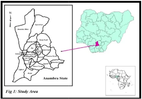
Study Area
Anambra is in the south-eastern part of Nigeria. The name is believed to have originated from ‘Oma-Mbala', (Wikipedia, 2012) which is the native name of the Anambra River, a tributary of River Niger. Moreover, Agulu River, Idemili River and Mamu River, constitute
S/No. Hardware
1. Intel Dual Processor(R) 3.0GHzProcessor, 4GB of RAM, 21” Color Screen Monitor, Keyboard, Mouse, UPS. 2. A0 Color and Panchromatic LaserJet plotter.
3. A0 High resolution scanner.
Digital soil mapping is a task towards optimizing the usefulness of studies (example Hengl, et al., and 2003; 2012) have shown that such operations are effective ways of ensuring steady availability of soil data. Moreover, they tend to guarantee regular update of soil data and remove limitations in their uses. Such operations offer significant supports to solving a myriad of environmental and geographical problems (example Platou, 1995) that spread across local, national and regional levels. New sets of data often result from further analysis of data obtained by such operations (Zhu et al., 1997 and 2001), and they tend to help overcome the limitations
With all these benefits, the aim of the present study is to make quantitative soil data available for Anambra, south eastern Nigeria, rom existing hardcopy soil map. This will be beneficial for understanding the causes and solution of gully erosion hazard in the area. Moreover, future scientific studies having to do with soil can Existing hardcopy soil maps were studied with view to finding their limitations. Geographic Information System (GIS) is the core tool for the study. The main data sources are sheets 7 and 8 of hardcopy soil map of Nigeria each at a displayable scale of documents, acquired from Federal
(FDALR, 1990), Abuja.
The maps were scanned and saved as JPEG image for easy sharing, and spatially referenced to WGS 1984 geographic coordinate system. he scanned images were subset and mosaicked to a unit seamless sheet covering Anambra. On-screen digitizing of the raster features was carried out. Finally, attribute table was created using various characteristics of soil types of Nigeria apping unit, geology, drainage, pH values, etc., and linked to the soil spatial data to form soil database for Anambra. For easy access, queries were built into the database, which simplified the provision of information to end users of the digital soil map of
eastern part of Nigeria. The name is believed Mbala', (Wikipedia, 2012) which is the native name of the Anambra River, a tributary of River Niger. Moreover, Agulu River, Idemili River and Mamu River, constitute a
the east and Kogi State to the north (See
land mass of 4844kmsq (1,870 sq. miles), and is densely populated. The area lies within longitudes 6
5o40’N and 6o49’N, within the humid tropical rainforest belt of
Nigeria and with an annual rainfall temperature range of about 25 – hours of about 1750hours.
The vegetation ranges from light rainforest to savannah, being controlled by geologic factors of topography, relief and lithology well as other anthropogenic factors (Oguntoyinbo, 1978). Gully erosion is a major environmental problem in the area. Most lands have been lost completely, and this situation occurs mainly around the western part (Obiadi et al., 2011).
Data Requirements
Table 1 below gives a summary of data and their sources, hardware and software applicable to the digital soil mapping for Anambra south eastern Nigeria.
METHODOLOGY
[image:2.595.45.556.502.790.2]Sheets 7 and 8 (Fig. 2) of the hardcopy soil map of Nigeria were prepared by electronic scanning and referenced spatially to WGS 84
Table 1. Study data and other Requirements
Software Intel Dual Processor(R) 3.0GHzProcessor, 4GB of RAM,
21” Color Screen Monitor, Keyboard, Mouse, UPS.
ERDAS Imagine 9.1 Hardcopy soil map of Nigeria acquired Department of Agricultural Land Resources, Abuja A0 Color and Panchromatic LaserJet plotter. ESRI ARCGIS 9.3 Political Map of Anambra each at a scale of 1:250,000
acquired from OSGof, Abuja
Microsoft Excel 2007 Soil analysis and description information contained in the reconnaissance soil survey report prepared in 1990 (acquired from the department of Agricultural Land Resources, Abuja)
the east and Kogi State to the north (See Fig 1). The area occupies a land mass of 4844kmsq (1,870 sq. miles), and is densely populated.
The area lies within longitudes 6o37’E and 7o20’E and latitudes
49’N, within the humid tropical rainforest belt of Nigeria and with an annual rainfall of about 2000-3000mm, average 27.5oC, and mean annual sunshine
The vegetation ranges from light rainforest to savannah, being controlled by geologic factors of topography, relief and lithology as well as other anthropogenic factors (Oguntoyinbo, 1978). Gully erosion is a major environmental problem in the area. Most lands have been lost completely, and this situation occurs mainly around the
a summary of data and their sources, hardware the digital soil mapping for Anambra,
Sheets 7 and 8 (Fig. 2) of the hardcopy soil map of Nigeria were electronic scanning and referenced spatially to WGS 84
Data and Sources
Hardcopy soil map of Nigeria acquired from Department of Agricultural Land Resources, Abuja Political Map of Anambra each at a scale of 1:250,000 acquired from OSGof, Abuja
UTM coordinate system using ESRI ArcGIS 9.3 software. Image sub-setting and mosaicking operation were subsequently performed to extract the area of interest from the prepared raster images and to form a seamless unit layer. Both operations were done in Leica Geosystem ERDAS IMAGINE 9.1. Digitizing the mapping units into polygons and final creation of attribute table was done in ArcGIS 9.3. The soil characteristics that were used to build the database are shown in Table 2 below. Queries (Fig 3) written in structured query language (SQL), were built into the database for easy access.
RESULTS AND DISCUSSIONS
The results of this research are Digital Soil Map of Anambra (DSMA) (Fig 4) and other derived thematic maps of soil characteristics such as
[image:3.595.91.519.216.761.2]soil slope (Fig 5), soil pH (Fig. 6), soil drainage (Fig. 7), soil texture (Fig. 8) soil ecological zones (Fig. 9) and geology (Fig. 10). Bar Chart (Fig.11) and Pie Chart (Fig. 12) are respectively shown to statistically describe the distribution of soil mapping units the area. The DSMA shows that the area is covered with 7 types of soil mapping units (2a, 2c, 5c, 5d, 6a, 9a and 17a) with soil mapping units 2a and 9a being the most dominant, covering about 37.38% and 27.81% of the total land area respectively. These soils are poorly drained, very strongly acidic, with slopes ranging between 0-2 percent
Table 2. Study data and other Requirements
S/No SOIL CHARACTERISTICS DESCRIPTION
1. Mapping Unit 58 mapping units from 1a-24b
2. Geology The forming background like Basement complex 3. Slope Differential topographies in Percentages 4. Ecological Zone Mostly Savanna and Wetlands
5. Drainage From poorly drained, moderately and highly drained 6. Soil pH Scales ranges from 3.0 – 8.0
7. pH Description Acidic, Basic or spectrum of either basic or acidic 8. Suitability to Mechanized Farming Moderately, Fairly, Marginally suitable or unsuitable 9. Soil Texture Sandy clay, Sandy Loam, clay loam, etc.
10. Soil Classification USDA or FAO classification categories 11. Vegetation cover Fallow, woodland, Grassland, etc. 12. Depth Deep, Most deep, Shallow, etc.
13. Percentage Distribution Distribution of mapping units around the country
14. Major Crops Particular crops supported majorly like yam, cassava, grains, etc.
Query 1: [Geology] = ‘Undifferentiated Basement Complex’ AND
[Suitability for mechanized farming] = ‘Moderately Suitable’
Query 2: [Drainage] = ‘Poorly Drained’ = ‘Poorly Drained’
Query 3: [pH Description] = ‘Very Strongly Acidic’ = ‘Very
Strongly Acidic’
Query 4:[Texture] = ‘Clay Loam’ = ‘Clay Loam’
Query 5:[Ecology] = ‘Rain Forest Soils’ = ‘Rain Forest Soils’
Query 6:[Crops] = ‘Yam and Cassava’ = ‘Yam and Cassava’
Figure 3: Some common SQL queries for the database
[image:3.595.83.244.542.763.2]Conclusion
The present study has attempted to produce a digital soil map of Anambra using a GIS technology. The result is believed to assist in understanding dynamics of gully erosion hazards in the area and providing solutions to the same. A significant contribution is made towards solving the problem of paucity of quantitative and accurate soil data. Thus, it tends to serve as facilitator towards research in food security for Nigeria and other social and environmental issues such as environmental sustainability, wealth creation and poverty alleviation. The study is limited to production of digital soil map using GIS technique. No attempt has been made to evaluate the accuracy of the generated soil maps, so as to know the extent to which the results can be relied upon, Further study is therefore recommended, which can take advantage of remote sensing technology to assess the reliability of the study outputs, as well as verify the assumption that gully erosion hazard in the area largely depends on soil mapping units distribution especially 2a and 9a.
Acknowledgement
The author wishes to thank the Federal Department of Agricultural Land Resources (FDALR) for providing the hard copy soil maps for the study and other authors whose works have also contributed in no small way.
REFERENCES
Daily Trust, (2010). Anambra: 'Light of the Nation' eclipsed by 500
gullies. Retrieved 2012, from http://weeklytrust.com.ng/index.
php?option=com_content&view=article&id=3119:anambra-light-of-the-nation-eclipsed-by-500-active-gullies-&catid=55:features &Itemid=170.
Egboka, B. and Nwankwo, G. (1986). The hydrogeological and geotechnical parameters as causative agents in the generation of erosion in rain forest belt of Nigeria. Journal of African Earth
Sciences, 3, 417-425.
Egboka, B. and Okpoko, I. (1984). Gully erosion in the Agulu-Nanka region of Anambra State, Nigeria. Proceedings of the Harare
symposium. IAHS Publication, 144, 335-347.
Ezechi, J. I. and Okagbue, C. O. (1989). A genetic classification of
gullies in eastern Nigeria and its implications on control
measures. 711-718. Journal of African Earth Sciences, 9,711-718. FDALR (Federal Department of Agricultural Land Resources), (1990). Reconnaissance Soil Survey Report of Nigeria. Volumes
1-4. Jos: FDALR.
Hengl, T., Rossiter, D.and Husnjak, S. (2003). Mapping soil properties from an existing national soil data set using freely available ancillary data. Bangkok.
Jamagne, M., Lebas, C., King, D. and Berland M. (1995). A geographical database for the soils of central and Eastern Europe. European Commission.
Kempen, B., Dick, J., Brus, J., Stoorvogel, J., Gerard, J., Heuvelink,
B. and de Vries, F. (2012). Efficiency Comparison of
Conventional and Digital Soil Mapping for Updating Soil maps.
Retrieved 2012, from http://dl.sciencesocieties.org/publications/ ssaj/abstracts/0/0/sssaj2011.0424.
Lark, M. (2007). Background to Digital Soil Mapping. International
Working group on Digital Soil Mapping Commission 1.5
Pedometrics. Rothamsted Research , Harpenden Hertfordshire, United Kingdom.
Nkwunonwo, U.C. and Okeke, F.I. (2013). GIS-based production of digital soil map for Nigeria. Ethiopian Journal of Environmental
Studies and Management, 6(5), 498-506.
Nwajide, C., and Hoque, H. (1979). Gullying processes in south eastern Nigeria. The Nigerian Fields, 44, 64-74.
Obiadi, I.I., Nwosu,C.M., Ajaegwu N.E., Anakwuba, E.K., Onuigbo, N.E.,Akpunonu, E.O. and Ezim,O.E. (2011). Gully Erosion in Anambra State, South East Nigeria: Issues and Solution.
International Journal of Environmental Sciences Volume 2 (2) ,
795-804.
Oguntoyinbo, J.S. (1978). Climate: Geography of Nigerian development. Heinemann Education Books (Nig.) Ltd., 45-70. Okagbue, C. O. and Uma, K.O. (1987). Performance of gully erosion
control measures in south eastern Nigeria. Proceeding of the
International Symposium on Forest Hydrology and Watershed Management (pp. 163-172). Vancouver, Canada: IAHS
Publication.
Okeke, F.I. and Nkwunonwo, U.C. (2007). Production of a Digital Soil Map/ Database for Nigeria. The Nigerian Journal of Space
Research.
Platou, S.W., Nørr, A.H. and Madsen, H. B. (1989). Digitisation of the EC Soil Map. In: Agriculture: computerization of land use
data. R.J.A Jones and B. Biagi (eds.). EUR 11151 EN, 12-24.
Office for Official Publications of the European Communities, Luxembourg.
Wikipedia. (2012). Anambra State. Retrieved from http://en. wikipedia.org/wiki/Anambra_State.
Zhu, A., Band, L., Vertessy, R. and Dutton, B. (1997). Derivation of soil properties using a soil land inference model (SoLIM). . Soil
Science Society of America Journal 61, 523– 533.
Zhu, A., Hudson, B., Burt, J., Lubich, K. and Simonson, D. (2001). Soil mapping using GIS, expert knowledge, and fuzzy logic. . Soil
Science Society of America Journal 65, 1463–1472.