https://doi.org/10.5194/hess-21-3427-2017 © Author(s) 2017. This work is distributed under the Creative Commons Attribution 3.0 License.
The evolution of process-based hydrologic models: historical
challenges and the collective quest for physical realism
Martyn P. Clark1, Marc F. P. Bierkens2, Luis Samaniego3, Ross A. Woods4, Remko Uijlenhoet5, Katrina E. Bennett6, Valentijn R. N. Pauwels7, Xitian Cai8, Andrew W. Wood1, and Christa D. Peters-Lidard9
1Research Applications Laboratory, National Center for Atmospheric Research, Boulder, CO 80301, USA 2Faculty of Geosciences, Utrecht University, 3508 TC Utrecht, The Netherlands
3UFZ-Helmholtz Centre for Environmental Research, 04318 Leipzig, Germany 4Department of Civil Engineering, University of Bristol, Bristol, BS8 1TR, UK
5Hydrology and Quantitative Water Management Group, Wageningen University, 6700 AA Wageningen, the Netherlands 6Los Alamos National Laboratory, Los Alamos, NM 87545, USA
7Department of Civil Engineering, Monash University, Victoria 3800, Australia
8Department of Civil and Environmental Engineering, Princeton University, Princeton, NJ 08544, USA 9Earth Sciences Division, NASA Goddard Space Flight Center, Greenbelt, MD 20771, USA
Correspondence to:Martyn P. Clark (mclark@ucar.edu)
Received: 28 December 2016 – Discussion started: 16 January 2017 Accepted: 31 May 2017 – Published: 11 July 2017
Abstract.The diversity in hydrologic models has historically led to great controversy on the “correct” approach to process-based hydrologic modeling, with debates centered on the ad-equacy of process parameterizations, data limitations and un-certainty, and computational constraints on model analysis. In this paper, we revisit key modeling challenges on require-ments to (1) define suitable model equations, (2) define ad-equate model parameters, and (3) cope with limitations in computing power. We outline the historical modeling chal-lenges, provide examples of modeling advances that address these challenges, and define outstanding research needs. We illustrate how modeling advances have been made by groups using models of different type and complexity, and we argue for the need to more effectively use our diversity of model-ing approaches in order to advance our collective quest for physically realistic hydrologic models.
1 Introduction
The research community exhibits great diversity in its ap-proach to hydrologic modeling, with different models posi-tioned at different points along a continuum of complexity. Models can be defined both in terms of process complexity
(i.e., to what extent do different models explicitly represent specific processes) and spatial complexity (i.e., to what ex-tent do different models explicitly represent details of the landscape and the lateral flow of water across model ele-ments). Such model diversity has led to great community debates on the “correct” approach to process-based hydro-logic modeling (Wood et al., 1988, 2011, 2012; Grayson et al., 1992a, b; Famiglietti and Wood, 1995; Reggiani et al., 1998; Beven, 2002; Sivapalan et al., 2003; Maxwell and Miller, 2005; Beven and Cloke, 2012), with the debate cen-tered around issues of the adequacy of process parameteri-zations, data limitations and uncertainty, and computational constraints on model analysis.
The purpose of this paper is to revisit the historical debates on process-based hydrologic modeling and ask the following question:How can we combine different perspectives on hy-drologic modeling to advance the quest for physical realism? (Kirchner, 2006; Clark et al., 2016). Specifically, we focus attention on the three fundamental questions that were posed by Freeze and Harlan (1969) in their seminal “blueprint” for a physically based hydrologic response model:
under-stood? Are the developments adaptable to a simulation of the entire hydrologic cycle?
2. Is it possible to measure or estimate accurately the con-trolling hydrologic parameters? Are the amounts of nec-essary input data prohibitive?
3. Have the earlier computer limitations of storage capac-ity and speed of computation been overcome? Is the ap-plication of digital computers to this type of problem economically feasible?
We posit that these questions, published almost 50 years ago, are very relevant today and nicely frame the debates on process-based hydrologic modeling.
We organize the paper around the three questions posed by Freeze and Harlan, on (1) model structure, (2) model parame-ter values, and (3) model execution (computing). We discuss these modeling challenges separately, while recognizing that these modeling challenges are strongly interdependent (e.g., a complex model structure may have large computing de-mands, restricting the extent to which it is possible to explore alternative model parameter sets). We will touch on these in-terdependencies in the individual sections of the paper.
For each question posed by Freeze and Harlan, we de-fine the major research challenges, and we provide exam-ples of different ways that the community has risen to meet these challenges, considering modeling approaches of vary-ing complexity. We do not mean to provide a comprehen-sive review; rather, we present possible solutions to outstand-ing modeloutstand-ing problems, focusoutstand-ing attention on the research sphere of Eric F. Wood. Our overall intent in writing this pa-per is to demonstrate how diverse hydrologic modeling ap-proaches advance the collective quest for physically realistic hydrologic models, and to define additional research that is necessary to further advance process-based hydrologic mod-els.
2 Model structure 2.1 Modeling challenges
The first question posed by Freeze and Harlan (1969) focuses on the adequacy of the mathematical descriptions of system of interest. Such mathematical descriptions define the struc-ture of a model. They include both the equations used to pa-rameterize individual processes and the interactions among processes and across scales.
A major research challenge addressed by Eric F. Wood is the problem of scaling, or closure (Wood et al., 1988; Blöschl and Sivapalan, 1995; Reggiani et al., 2001; Beven, 2006), i.e., how best to represent the influence of small-scale het-erogeneities on large-scale fluxes, and how best to represent interactions among processes and the connectivity of water across the landscape. The scaling challenge is ubiquitous. For example, Mahrt (1987) demonstrates how localized areas of
instability can dominate large-scale energy fluxes; Scott et al. (2008) demonstrate that transpiration from narrow ripar-ian corridors in arid regions is much greater than the local precipitation; Seyfried et al. (2009) demonstrate that deep snow drifts produce local runoff “hotspots” that generate a disproportionate amount of the catchment runoff; Tromp-van Meerveld and McDonnell (2006a, b) demonstrate that the water stored in bedrock depressions must be raised to a sufficient level in order to connect bedrock depressions and generate hillslope outflow. The community has risen to meet these scaling challenges in very different ways – different models use very different sets of equations to describe the large-scale manifestation of spatial heterogeneity, process in-teractions, and connectivity.
The different solutions to the scaling and closure prob-lem can be distinguished by the extent to which the ef-fort is focused on developing new large-scale flux param-eterizations or numerically integrating the small-scale het-erogeneities across space. Such differences are perhaps best illustrated by considering the different approaches used to simulate the transmission of water through catchments. In bucket-style rainfall–runoff models – at the simplest end of the complexity continuum – the large-scale transmission of water is often defined as a linear (or near-linear) function of water storage (e.g., see the synthesis in Clark et al., 2008 and the recent review by Hrachowitz and Clark, 2017). Such large-scale closure relations implicitly represent the small-scale heterogeneity of flow paths, including the localized ar-eas of high conductivity (e.g., macropores) that dominate the large-scale response (Beven and Germann, 1982; McDon-nell, 1990). By contrast, the more complex 3-D variably satu-rated flow models typically use small-scale closure relations (Maxwell and Miller, 2005; Rigon et al., 2006), where un-saturated hydraulic conductivity is defined as a highly non-linear function of soil moisture (e.g., Van Genuchten, 1980). These 3-D models compute large-scale fluxes by spatially in-tegrating the small-scale heterogeneities (Maxwell and Kol-let, 2008; Kollet et al., 2010). The differences in solutions to the scaling problem are not mutually exclusive, as many models include a mix of small-scale and large-scale flux pa-rameterizations (e.g., VIC, the variable infiltration capacity model, uses a large-scale parameterization of infiltration, yet relies on small-scale equations to simulate the storage and transmission of water through the upper portion of the soil matrix).
When viewed in this way, the different solutions to the scaling and closure problem can be shared among different modeling groups that employ very different modeling ap-proaches. To explain this perspective, consider the inequal-ity that describes ideal relationships between the model res-olution and the length scale of resolved and unresolved pro-cesses (Wood et al., 1988):
wherelis the length scale of the rapidly varying hydrologic response,Lis the length scale of the slowly varying quanti-ties, andDis the length scale of the model element (note the assumption that the spatial scale of processes below the grid resolution is clearly separated from the spatial scale of pro-cesses above the model resolution – a condition that is rarely achieved in practice; Fan and Bras, 1995). Critically, Eq. (1) requires that processes below the length scale of the model element must be represented implicitly (e.g., through large-scale flux parameterizations) and processes above the length scale of the model element must be represented explicitly (e.g., through numerical integration over spatially distributed model elements).
The trend towards “hyper” resolution land models (Wood et al., 2011), e.g., 1 km or 100 m over large geographical do-mains, emphasizes the need for general parameterizations of hydrological processes on this scale. However, this is still an unsolved problem: we do not have firm evidence that the structure and parameter values of our element-scale equa-tions correspond to hydrologic reality at those scales. One of the most important causes of this difficulty is the spatial heterogeneity in the initial and boundary conditions, and in the material properties of the medium. This heterogeneity occurs at multiple spatial scales, and has multiple physical causes (Seyfried and Wilcox, 1995). The multiple scales of heterogeneity are manifest as multiple dominant processes (Grayson and Blöschl, 2001), and also as processes without a well-defined spatial scale (e.g. preferential flow in the snow-pack, on the land surface, in the subsurface). These prob-lems cannot be solved solely by numerical integration across space. The next section summarizes recent advances in de-veloping large-scale flux parameterizations and in effectively resolving dominant processes.
2.2 Modeling solutions
The common challenge of developing large-scale flux pa-rameterizations has been addressed in a number of ways. One class of methods is that of statistical–dynamical flux pa-rameterizations, where large-scale fluxes are defined based on probability distributions of subgrid or subelement model state variables. For example, area-average infiltration can be parameterized based on probability distributions of water ta-ble depth (Beven and Kirkby, 1979; Sivapalan et al., 1987) or on probability distributions of soil moisture (Moore and Clarke, 1981; Wood et al., 1992). Statistical–dynamical ap-proaches are also used to parameterize the impact of frozen soils on area-average infiltration (Koren et al., 1999) and the impact of spatial variability of snow on area-average energy fluxes (Luce et al., 1999; Liston, 2004; Clark et al., 2011a). Another class of methods consists of scale-dependent param-eterizations, where new flux parameterizations are defined directly on the scale of interest. Examples of this class of methods include the empirically derived storage–discharge relationships described earlier, where the large-scale
trans-mission of water is often defined as a linear (or near-linear) function of water storage (Ambroise et al., 1996; Clark et al., 2008; Fenicia et al., 2011; Brauer et al., 2014). Simi-larly, large-scale stability corrections, used in computations of land–atmosphere energy fluxes, implicitly represent the impact of local pockets of instability on large-scale fluxes (Mahrt, 1987). There is a strong need to synthesize, evaluate, and compare these large-scale parameterizations in order to improve the physical realism of hydrologic models (Clark et al., 2011b, 2015b, 2016).
Statistical–dynamical flux parameterizations rely on the assumption that the model-scaleDis large compared to the length- or time-scale of the heterogeneity of hydrological response l. In other words, the size of a model element is large compared to the scale of fluctuation (Rodríguez-Iturbe, 1986) or the integral scale (Dagan, 1994) of the underlying process. In that case, univariate probability density functions can be used that, when spatially, temporally, or probabilis-tically integrated, result in representative parameters on the scale of the model elements that do not depend on the model state (called full closure). However, it becomes more difficult to define scale-aware parameterizations iflandDare compa-rable in scale. Here, much can be learned from the upscaling research that has been done in stochastic subsurface hydrol-ogy to derive representative hydraulic conductivities on the scale of model blocks (see Sánchez-Vila et al., 1996 for a re-view). These approaches can be divided into two main cate-gories (Bierkens and Van der Gaast, 1998): direct upscaling, whereby the spatial statistics (i.e. mean and spatial covari-ance) of the block-scale hydraulic conductivity are directly derived from integrating the small scale spatial statistics, and indirect upscaling where the hydraulic conductivity is first stochastically simulated or interpolated on the smallest scale and then upscaled by nonlinear averaging. Direct methods work best for heterogeneity that can be described by multi-Gaussian random functions. However, numerical integration across space may be necessary if the heterogeneity is more organized or of larger complexity. It is important to notice, however, that full closure is often not possible, resulting in representative parameterizations that change with the model state.
leaves to improve scaling from the leaf to the canopy. Sim-ilarly, Swenson and Lawrence (2012) make separate energy balance calculations over snow-covered and snow-free ter-rain to improve estimates of large-scale energy fluxes. On the system scale, many models spatially integrate across dis-crete landscape types to capture the large-scale manifestation of small-scale heterogeneity (e.g., Flügel, 1995; Tague and Band, 2004). For example, Newman et al. (2014) spatially integrate across a small number of discrete landscape types in order to reproduce the local runoff “hotspots” described by Seyfried et al. (2009). More recently, Chaney et al. (2016a) demonstrate that the use of spatially interacting hydrologic response units can reduce computational cost of a fully dis-tributed hydrologic model by 3 orders of magnitude without appreciable losses in information. Like the large-scale flux parameterizations, there is a strong need to rigorously com-pare different approaches to explicitly resolve dominant pro-cesses.
An interesting twist is the interplay between explicitly rep-resenting small-scale processes and avoiding or reducing re-dundant calculations across large model domains. For exam-ple, in the push for hillslope-resolving models across large geographical domains, one approach is to use the concept of representative hillslopes (Troch et al., 2003; Hazenberg et al., 2015; Ajami et al., 2016). The representative hillslope has a length dimension much smaller than the length scale of the model element, and the hillslope is discretized into columns along an axis perpendicular to the stream to explic-itly resolve lateral flow processes. The hydrologic and energy fluxes from the single hillslope, or averaged across local hill-slopes of different types, are then considered representative of the model element as a whole. This approach spatially in-tegrates both along a hillslope and among hillslopes. Such multiscale approaches show considerable promise and will likely be increasingly used to represent how small-scale het-erogeneities, interactions among processes, and the connec-tivity of water across the landscape affects large-scale behav-ior.
A broader challenge is to simulate the myriad controls on catchment evolution, e.g., to predict how energy gradi-ents dictate landscape evolution, how natural selection fa-vors plants that make optimal use of available resources, and how the dynamic interactions between humans and the envi-ronment shapes the storage and transmission of water across the landscape (Rodríguez-Iturbe et al., 1992; Eagleson, 2002; Schymanski et al., 2009, 2010; Sivapalan et al., 2012; Har-man and Troch, 2014; Zehe et al., 2014; Clark et al., 2016; Grant and Dietrich, 2017). Addressing this challenge re-quires shifting focus from traditional approaches at short timescales where “properties define processes” (Gupta et al., 2012) towards approaches on longer timescales that focus on predicting how “processes define properties” (Rodríguez-Iturbe et al., 1992; Eagleson, 2002; Harman and Troch, 2014). Importantly, it requires the treatment of humans as
an endogenous component of the Earth system (Sivapalan et al., 2012; Clark et al., 2015a).
There are of course multiple possible approaches avail-able to simulate dominant hydrologic processes. A useful path forward is to isolate and scrutinize alternative modeling approaches to represent scaling and heterogeneity. Peters-Lidard et al. (2017) propose the idea that the approximations in our models can be treated as hypotheses that can be tested in an information-based framework. Such advances in model evaluation methods will be critical in order to accelerate ad-vances in process-based hydrologic models.
3 Model parameters
3.1 Parameter estimation challenges
The second question posed by Freeze and Harlan (1969) fo-cuses on the availability of data to define system properties (model parameter values).
A key part of this modeling challenge revolves around the availability and quality of spatial information on model pa-rameters. For some model parameters, spatial information is not readily available. Examples of missing parameters in-clude those that define the temporal decay of snow albedo and the recession characteristics of shallow aquifers. In such situations process-based hydrologic and land models often treat these uncertain parameters as physical constants, adopt-ing hard-coded parameters that are selected based on order-of-magnitude considerations or on limited experimental data (Mendoza et al., 2015; Cuntz et al., 2016). For other parame-ters the available spatial information is limited to broad land-scape characteristics, e.g., the parameters controlling carbon assimilation and stomatal conductance are typically tied to vegetation type (Bonan et al., 2011; Niu et al., 2011), or the available soil maps impose the same hydraulic properties over large areas (Miller and White, 1998). Such ill-defined information on vegetation and soils greatly underestimates the tremendous spatial heterogeneity that occurs in nature. Finally, when spatial information does exist it may have limited spatial representativeness and relevance – for exam-ple, the information on hydraulic conductivity from soil pits may only have weak relations with the transmission of water throughout catchments (Beven, 1989).
3.2 Parameter estimation solutions
The solutions to improving information on model parame-ters are general and can be applied across multiple models of different type and complexity. We see three specific paths forward. First, there are numerous opportunities to improve information on geophysical properties, including estimates of vegetation structure (Simard et al., 2011), soil depth (Pel-letier et al., 2016), soil properties (Chaney et al., 2016b), bedrock depth and permeability (Fan et al., 2015), and the physical characteristics of rivers (Gleason and Smith, 2014). Second, it is possible to improve the way that geophysical information is used to estimate model parameters. For ex-ample, the multiscale parameter regionalization (MPR) ap-proach of Samaniego et al. (2010) focuses attention squarely on the transfer functions that relate geophysical attributes to model parameters – Samaniego et al. (2010) apply transfer functions on the finest spatial scale of the geophysical data (e.g., the soil polygons) and then apply parameter-dependent operators to upscale the fine-scale model parameters to the resolution of the model. The parameter estimation in MPR is hence centered on the coefficients in the transfer functions used to relate geophysical attributes to model parameters, maximizing the information extracted from the geophysical data. Much research has focused on pedotransfer functions to relate soil properties to soil parameters (e.g., Schaap et al., 2001; Soet and Stricker, 2003), and there has been limited work to relate geophysical attributes to other model parame-ters such as those controlling the impact of soil moisture on saturated areas (Balsamo et al., 2011).
Third, there is considerable scope to improve the way that multivariate data are used to constrain model parameter val-ues. A key path forward is to identify different signatures from the data that can be used to improve parameter values in different parts of the model (Gupta et al., 2008; Yilmaz et al., 2008; Pokhrel et al., 2012; Vrugt and Sadegh, 2013; Rakovec et al., 2015). For example, Troy et al. (2008) use re-gionalized estimates of the precipitation:runoff ratio to con-strain the VIC model at the grid scale, and there is much more that can be done using such methods (e.g., see the ap-proach of Yadav et al., 2007). In the distributed model con-text, signatures related to energy and moisture fluxes may now be constrained by remote sensing imagery, e.g. of skin temperature or ET, though this strategy is far from common today. Similarly, remotely sensed estimates of surface water levels (Revilla-Romero et al., 2016) and total basin storage (Tangdamrongsub et al., 2015) could be used as well as re-ported statistics on water withdrawal (Wada et al., 2014). To-gether, a focused effort on improving geophysical informa-tion, improving the links between geophysical information and model parameters, and better constraining model param-eters, will go a long way towards improve parameter values across multiple models.
A very different solution is stochastic modeling (e.g., see Kim et al., 1997). Stochastic modeling accepts that many
pa-rameters are impossible to measure or estimate and instead generates synthetic model parameter fields using probabil-ity distributions with assumed length scales. For example, Maxwell and Kollet (2008) use spatially correlated random fields of saturated hydraulic conductivity to define the fine-scale spatial structure of their model domain, and evaluate the impact of this fine-scale structure on hillslope runoff. Similar approaches were used by Kollet et al. (2010) in their proof-of-concept study illustrating the spatial integration of fine-scale 3-D variably saturated flow simulations. These ap-proaches derive from the indirect upscaling methods (numer-ical integration across space) developed in stochastic subsur-face hydrology. The downside of such stochastic simulation approaches is that multiple realizations are necessary to sepa-rate the signals from the imposed random variability, making such approaches computationally challenging for fine-scale simulations over large geographical domains (Fatichi et al., 2016).
A major challenge is the parameterization of the deeper subsurface on regional to continental scales in order to sup-port large-domain groundwater modeling (Bierkens, 2015; Clark et al., 2015a). Advances in estimating parameters of the subsurface may profit from new technologies. For ex-ample, it will be possible to use monitoring and exploration technologies (e.g., geophysics) to generate ensembles of hy-draulic conductivity fields. Once these fields are estimated at high resolution, MPR could be used to estimate effective hy-draulic conductivity values to characterize the required sub-surface parameters. Also, stochastic methods need to be ex-tended to capture the large structural variability in the forma-tions and layers that dominate continental domains (Baroni et al., 2017; Schalge et al., 2016).
4 Model execution (computing) 4.1 Computing challenges
In their final question Freeze and Harlan (1969) ask if the computer limitations of storage capacity and speed of com-putation have been overcome, and if their blueprint for process-based hydrologic modeling is now economically fea-sible. Interestingly, we have made substantial (and econom-ically feasible) advances in computing, yet we have also pushed beyond what they could envision with model resolu-tion and process complexity. As a result, computing remains, ironically, a present-day challenge, and we still routinely push available computing resources to their limit (Kollet et al., 2010; Wood et al., 2011). We still struggle with trade-offs between process complexity, spatial complexity, domain size, ensemble size, and the time period of the model simu-lation. We also still struggle to run our most complex mod-els for a large number of model configurations, for example, experimenting with different model parameter sets, different process parameterizations, and different spatial architectures. To answer Freeze and Harlan’s question: the computing lim-itations have not been overcome.
The challenge is as follows: as we push our models to their computational limit, the expense of these complex config-urations may permit only a single deterministic simulation for a short time period (e.g., Maxwell et al., 2015; Fatichi et al., 2016). Such preferences for complexity and large-domain simulations arguably sacrifice opportunities for model anal-ysis, model improvement, and uncertainty characterization. Complex models may struggle with physical realism because computational limitations constrain capabilities to identify and resolve model weaknesses. Paradoxically, more complex models may achieve less physical realism than computation-ally frugal alternatives. This is a critical concept – though a counterintuitive one – that ideally should guide the develop-ment of new model applications.
4.2 Computing solutions
There are several solutions to these computational chal-lenges, all of which are now being advanced by leading process-based hydrologic modeling groups. The first solu-tion, and the most obvious, is to exploit advances in mas-sively parallel (e.g., exa-scale) computation (Kollet et al., 2010; Wood et al., 2011; Paniconi and Putti, 2015; Fatichi et al., 2016). This solution is often implemented by running a complex model at the finest grid resolution possible over the domain of interest (e.g., Maxwell et al., 2015; Maxwell and Condon, 2016). A key reason for conducting such spatially resolved simulations is to understand explicit spatial controls on hydrologic processes. For example, Maxwell and Condon (2016) use high-resolution continental-domain ParFlow sim-ulations to understand the controls of groundwater flow on
the partitioning of evapotranspiration into bare soil evapora-tion and transpiraevapora-tion.
A second (related) solution to the computing challenge is to improve numerical solvers. In simpler models the need for robust numerical methods is often undervalued, and numeri-cal errors in simple models contaminate model analysis and complicate model calibration (Kavetski et al., 2006b; Kavet-ski and Clark, 2010, 2011). For example, the “pits” in model parameter surfaces have been shown to be an artifact of nu-merical solution methods, requiring development of elabo-rate and time-consuming parameter estimation stelabo-rategies that are not necessary in models with robust numerical solutions (Kavetski et al., 2006a; Clark and Kavetski, 2010; Kavet-ski and Clark, 2010). In more complex models, advances in solution methods are an active area of research, with sev-eral recent advances in numerical solvers and parallelization strategies (Qu and Duffy, 2007; Kumar et al., 2009; Kol-let et al., 2010; Maxwell, 2013). Across all models there is a need to improve numerical solution methods (e.g., evalu-ate accuracy–efficiency tradeoffs) to support efficient model analysis and calibration strategies.
A third solution to the computing challenge is to identify model configurations that avoid redundant calculations while still capturing dominant processes. This can be accomplished using the concept of hydrologic similarity, i.e., recognizing that there is no need to repeat calculations for areas of the landscape with very similar forcing and geophysical prop-erties (e.g., Flügel, 1995; Tague and Band, 2004). As noted earlier, recent applications of hydrologic similarity methods have shown that it is possible to reduce run times by 2 to 3 orders of magnitude, without any loss in information con-tent (Newman et al., 2014; Chaney et al., 2016a). Also, hy-drologic similarity concepts can be effectively applied using multiscale methods to resolve the dominant spatial gradi-ents that drive flow; for example, using representative hill-slopes to explicitly resolve lateral flow processes (Troch et al., 2003; Berne et al., 2005; Hazenberg et al., 2015; Ajami et al., 2016). In exploring these solutions, we recognize that there is not necessarily a tradeoff between physical realism and computational efficiency – the linkage between spatial complexity and process complexity may be rather weak, as models that are run using a large number of spatial elements may still miss dominant processes (e.g., Hartmann et al., 2017).
"Observedreality" C,H2O,N,...,Pcycles
Community modeling framework Execution
decoding
Observations encoding
Model parameters
Model 1 Model n
Testable
Theoretical underpinnings
Model complexity Parameter estimation
Model analysis
Newobservation technologies
[image:7.612.128.468.74.251.2]Reusable Modular
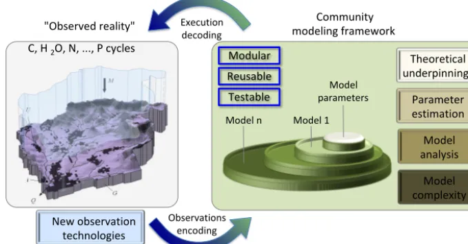
Figure 1.Schematic summarizing some key research priorities to advance the physical realism of process-based hydrologic models. Note that the framework accommodates multiple models (model 1, . . . , model n).
estimate transfer function parameters at coarser resolutions instead of using a high-resolution model setting. Since pa-rameters obtained with the MPR technique are transferable across scales without significant performance loss, models can be applied at higher spatial resolutions as shown by Ku-mar et al. (2013). This alternative would lead to computa-tionally efficient large-scale hydrologic predictions and al-lows for the performance of parameter estimation over large domains.
In short, solving computing challenges will require ju-diciously combining emerging computing capabilities, ad-vanced numerical methods, justifiable model simplifications, and extensive use of computationally frugal model analysis methods.
5 Summary and next steps
In this paper, we review key advances in process-based hy-drologic models. We see that the community has risen to meet major hydrologic modeling challenges in diverse and productive ways. Specifically, the community has made note-worthy advances in improving mathematical descriptions of hydrologic processes, in parameter estimation, and in iden-tifying justifiable model simplifications that make more ef-fective use of available computing resources. Many of these modeling advances are general, and can be applied across multiple models of different type and complexity.
To summarize, there are three general opportunities to im-prove the physical realism of hydrologic models. First, there is still considerable scope to improve mathematical descrip-tions of hydrologic processes. A major research challenge is the scaling and closure problem, i.e., how to represent how small-scale heterogeneities shape large-scale fluxes, in-teractions among processes, and the connectivity of
wa-ter across the landscape. While the hydrological modeling community has made progress in this challenge, through statistical–dynamical models, stochastic upscaling theory, scale-appropriate flux parameterizations, and spatial integra-tion across discrete landscape types, much work is still re-quired both to develop new closure schemes and to systemat-ically compare existing modeling approaches. Second, there is considerable scope to improve information on model pa-rameter values and their associated uncertainties. Advances in parameter estimation will require a focused effort to im-prove the available geophysical information (e.g., through improved observations), improve the links between geophys-ical information and model parameters, and advance methods to use multivariate data to constrain model parameter values. Third, there is a strong need to more effectively use the avail-able computing resources. We argue here that in addition to exploiting advances in massively parallel computation and numerical solution methods, we can also make much more effective use of the available computing through more ef-ficient and/or agile models (e.g., use of hydrologic similar-ity concepts). More effective use of available computing re-sources can increase capabilities for model analysis and un-certainty characterization, and shine the light toward further model improvements.
We see several specific needs underlying these general re-search themes (see Fig. 1 for the general framework):
exper-imentalists and modelers is focused on individual wa-tersheds (e.g., Tromp-van Meerveld and Weiler, 2008; Hopp and McDonnell, 2009). More work is needed to synthesize process explanations from research water-sheds to develop more general theories of hydrologic processes (e.g., Tetzlaff et al., 2009) and test these alter-native process descriptions in models.
2. We need to expand our prominence in community hydrologic modeling (Wood et al., 2005; Weiler and Beven, 2015), both by providing accessible and exten-sible modeling tools, and also providing key research datasets and model test cases to scrutinize alternative modeling approaches. Such community activities will result in greater engagement of field scientists in model development and greater collaboration across diverse modeling groups, resulting in substantial improvements in the physical realism and predictive capabilities of hy-drologic models. Advancing such community activities requires that we are much more effective and efficient in sharing data and model source code. This goes beyond just making models and data publicly available by, criti-cally, integrating models and data in widely used analy-sis frameworks and developing model standards to sim-plify the sharing of source code in models developed by different groups (Clark et al., 2015b, 2016).
3. We need to systematically and comprehensively explore the benefits of competing modeling approaches (Clark et al., 2015a, b, 2016). A key need is to systemati-cally evaluate information gains and losses using mod-els of varying complexity, exploring the interplay be-tween changes in process complexity and changes in spatial complexity. These assessments will help identify useful model configurations for specific applications. Another need is to scrutinize models using data from research watersheds, using data on both internal states or fluxes and intervariable relationships, in order to un-derstand the benefits of competing process parameteri-zations. More generally, and as emphasized by Peters-Lidard et al. (2017), it is important to use applications of information theory to quantify how effectively mod-els use the available information, i.e., to provide an esti-mate of system predictability and identify opportunities to improve models.
4. We need to substantially advance the development of new modeling approaches that simulate the temporal dynamics of environmental change. Key challenges in-clude predicting how energy gradients dictate landscape evolution, how natural selection favors plants that make optimal use of the available resources, and how the dynamic interactions between humans and the envi-ronment shapes the storage and transmission of water across the landscape (Rodríguez-Iturbe et al., 1992; Ea-gleson, 2002; Schymanski et al., 2009, 2010; Sivapalan
et al., 2012; Harman and Troch, 2014; Zehe et al., 2014; Clark et al., 2016; Grant and Dietrich, 2017).
5. We must advance research on process-oriented ap-proaches to estimate spatial fields of model parame-ters. The challenge is to estimate spatial variations in the storage and transmission properties of the land-scape. Advances are possible through the development of new data sources on geophysical attributes (Simard et al., 2011; Gleason and Smith, 2014; Fan et al., 2015; Chaney et al., 2016b; Pelletier et al., 2016; De Graaf et al., 2017), new approaches to link geophysical attributes to model parameters (Samaniego et al., 2010; Kumar et al., 2013; Rakovec et al., 2015), and new diagnos-tics to infer model parameters (Gupta et al., 2008; Yil-maz et al., 2008; Pokhrel et al., 2012). Such focus will give the parameter estimation problem the scientific at-tention that it deserves, rather than the far-too-common approach where parameter estimation is relegated to a “tuning exercise” in model applications. This focus on parameter estimation is necessary to improve the physi-cal realism and applicability of process-based models. 6. We need to obtain better data on hydrologic processes.
Field campaigns to obtain new data to understand hy-drologic processes are less supported and supportable than before (Tetzlaff et al., 2017); thus a key need is to motivate and design new field experiments to advance understanding of the terrestrial component of the water cycle across scales and locations. Such work is critical to ensure model development is not unduly constrained by the limited experimental field data that we have at present.
7. We need to advance methods for model analysis, espe-cially for complex models. As mentioned above, analy-sis of complex models is possible by both (a) developing surrogate models, i.e., models that emulate the behavior of complex models and run very quickly (Razavi et al., 2012); and (b) applying computationally frugal model analysis methods that require fewer model simulations (Rakovec et al., 2014; Hill et al., 2015). These advances in model analysis are important because complex mod-els are typically calibrated or analyzed using semiman-ual or mansemiman-ual strategies, largely due to their immense computational cost (it is only possible to run a handful of simulations). We have very little insight into process– parameter dominance and process–parameter interac-tions in very complex models; however, such informa-tion is desperately needed in order to inform meaningful parameter estimation strategies.
their particular project, and the overall construction of the model has become rather messy. Clark et al. (2015b) define some key requirements as follows: (a) impose modularity at the level of the individual fluxes, to en-able greater model extensibility and code reuse, as it is straightforward to combine different flux parame-terizations to form alternative conservation equations; (b) separate the physical processes from their numeri-cal solution, to enable experimentation with alternative numerical solution methods, e.g., evaluating accuracy– efficiency tradeoffs; and (c) use hierarchal data struc-tures, to enable representation of spatial variability and connectivity across a range of spatial scales. Such im-provements in model construction are a critical under-pinning activity that is critical to accelerate advances in hydrologic science.
In addressing these research tasks it is important to take a unified perspective – it is important to deliberately depart from previous debates on the “correct” approach to hydro-logic modeling, and focus instead on more effective use of the diversity of modeling tools to advance our collective quest for physically realistic hydrologic models.
Data availability. No data sets were used in this article.
Competing interests. The authors declare that they have no conflict of interest.
Special issue statement. This article is part of the special issue “Observations and modeling of land surface water and energy ex-changes across scales: special issue in Honor of Eric F. Wood”. It is a result of the Symposium in Honor of Eric F. Wood: Observations and Modeling across Scales, Princeton, New Jersey, USA, 2–3 June 2016.
Acknowledgements. We thank John Ding, Murugesu Sivapalan,
Thorsten Wagener, Eric Wood, and an anonymous referee for their constructive comments on an earlier version of this paper.
Edited by: Dennis Lettenmaier
Reviewed by: Thorsten Wagener, Murugesu Sivapalan, Eric Wood, and one anonymous referee
References
Ajami, H., Khan, U., Tuteja, N. K., and Sharma, A.: Development of a computationally efficient semi-distributed hydrologic modeling application for soil moisture, lateral flow and runoff simulation, Environ. Modell. Softw., 85, 319–331, 2016.
Ambroise, B., Freer, J., and Beven, K.: Application of a generalized TOPMODEL to the small Ringelbach
catch-ment, Vosges, France, Water Resour. Res., 32, 2147–2159, https://doi.org/10.1029/95wr03715, 1996.
Balsamo, G., Pappenberger, F., Dutra, E., Viterbo, P., and van den Hurk, B.: A revised land hydrology in the ECMWF model: a step towards daily water flux prediction in a fully-closed water cycle, Hydrol. Process., 25, 1046–1054, https://doi.org/10.1002/hyp.7808, 2011.
Baroni, G., Zink, M., Kumar, R., Samaniego, L., and Attinger, S.: Effects of uncertainty in soil properties on simulated hydrologi-cal states and fluxes at different spatio-temporal shydrologi-cales, Hydrol. Earth Syst. Sci., 21, 2301–2320, https://doi.org/10.5194/hess-21-2301-2017, 2017.
Berne, A., Uijlenhoet, R., and Troch, P. A.: Similar-ity analysis of subsurface flow response of hillslopes with complex geometry, Water Resour. Res., 41, 9, https://doi.org/10.1029/2004WR003629, 2005.
Beven, K. and Germann, P.: Macropores and water flow in soils, Water Resour. Res., 18, 1311–1325, 1982.
Beven, K.: Changing ideas in hydrology – the case of physically-based models, J. Hydrol., 105, 157–172, https://doi.org/10.1016/0022-1694(89)90101-7, 1989.
Beven, K.: Searching for the Holy Grail of scientific hydrology: Qt=(S, R, 1t )Aas closure, Hydrol. Earth Syst. Sci., 10, 609– 618, https://doi.org/10.5194/hess-10-609-2006, 2006.
Beven, K. J. and Kirkby, M. J.: A physically based, variable con-tributing area model of basin hydrology, Hydrolog. Sci. J., 24.1, 43–69, https://doi.org/10.1080/02626667909491834, 1979. Beven, K. J.: Towards an alternative blueprint for a physically
based digitally simulated hydrologic response modelling system, Hydrol. Process., 16, 189–206, https://doi.org/10.1002/hyp.343, 2002.
Beven, K. J. and Cloke, H. L.: Comment on “Hyperresolution global land surface modeling: Meeting a grand challenge for monitoring Earth’s terrestrial water” by Eric F. Wood et al., Water Resour. Res., 48, https://doi.org/10.1029/2011WR010982, 2012. Bierkens, M. and Van der Gaast, J.: Upscaling hydraulic
conduc-tivity: theory and examples from geohydrological studies, Nutr. Cycl. Agroecosys., 50, 193–207, 1998.
Bierkens, M. F.: Global hydrology 2015: State, trends, and direc-tions, Water Resour. Res., 51, 4923–4947, 2015.
Blöschl, G. and Sivapalan, M.: Scale issues in hydrolog-ical modelling: a review, Hydrol. Process., 9, 251–290, https://doi.org/10.1002/hyp.3360090305, 1995.
Bonan, G. B., Lawrence, P. J., Oleson, K. W., Levis, S., Jung, M., Reichstein, M., Lawrence, D. M., and Swenson, S. C.: Im-proving canopy processes in the Community Land Model ver-sion 4 (CLM4) using global flux fields empirically inferred from FLUXNET data, J. Geophys. Res.-Biogeo., 116, G02014, https://doi.org/10.1029/2010jg001593, 2011.
Brauer, C. C., Teuling, A. J., Torfs, P. J. J. F., and Uijlenhoet, R.: The Wageningen Lowland Runoff Simulator (WALRUS): a lumped rainfall-runoff model for catchments with shallow groundwater, Geosci. Model Dev., 7, 2313–2332, https://doi.org/10.5194/gmd-7-2313-2014, 2014.
Chaney, N. W., Wood, E. F., McBratney, A. B., Hempel, J. W., Nau-man, T. W., Brungard, C. W. and Odgers, N. P.: POLARIS: A 30-meter probabilistic soil series map of the contiguous United States, Geoderma, 274, 54–67, 2016b.
Clark, M. P., Slater, A. G., Rupp, D. E., Woods, R. A., Vrugt, J. A., Gupta, H. V., Wagener, T., and Hay, L. E.: Framework for Under-standing Structural Errors (FUSE): A modular framework to di-agnose differences between hydrological models, Water Resour. Res., 44, W00B02, https://doi.org/10.1029/2007WR006735, 2008.
Clark, M. P. and Kavetski, D.: Ancient numerical daemons of conceptual hydrological modeling: 1. Fidelity and efficiency of time stepping schemes, Water Resour. Res., 46, W10510, https://doi.org/10.1029/2009wr008894, 2010.
Clark, M. P., Hendrikx, J., Slater, A. G., Kavetski, D., Anderson, B., Cullen, N. J., Kerr, T., Hreinsson, E. O., and Woods, R. A.: Representing spatial variability of snow water equivalent in hy-drologic and land-surface models: A review, Water Resour. Res., 47, W07539, https://doi.org/10.1029/2011wr010745, 2011a. Clark, M. P., Kavetski, D., and Fenicia, F.: Pursuing the
method of multiple working hypotheses for hydro-logical modeling, Water Resour. Res., 47, W09301, https://doi.org/10.1029/2010WR009827, 2011b.
Clark, M. P., Fan, Y., Lawrence, D. L., Adam, J. C., Bolster, D., Gochis, D., Hooper, R. L., Kumar, M., Leung, L. R., Mackay, D. S., Maxwell, R. M., Shen, C., Swenson, S. C., and Zeng, X.: Improving the representation of hydrologic pro-cesses in Earth System Models, Water Resour. Res., 5929–5956, https://doi.org/10.1002/2015WR017096, 2015a.
Clark, M. P., Nijssen, B., Lundquist, J., Kavetski, D., Rupp, D., Woods, R., Gutmann, E., Wood, A., Brekke, L., Arnold, J., Gochis, D., and Rasmussen, R.: A unified approach to process-based hydrologic modeling. Part 1: Modeling concept, Water Resour. Res., 51, 2498–2514, https://doi.org/10.1002/2015WR017198, 2015b.
Clark, M. P., Schaefli, B., Schymanski, S. J., Samaniego, L., Luce, C. H., Jackson, B. M., Freer, J. E., Arnold, J. R., Dan Moore, R., Istanbulluoglu, E., and Ceola, S.: Improving the theoretical underpinnings of process-based hydrologic models, Water Re-sour. Res., 2350–2365, https://doi.org/10.1002/2015WR017910, 2016.
Cuntz, M., Mai, J., Samaniego, L., Clark, M., Wulfmeyer, V., Branch, O., Attinger, S., and Thober, S.: The impact of standard and hard-coded parameters on the hydrologic fluxes in the Noah-MP land surface model, J. Geophys. Res.-Atmos., 121, 10676– 10700, https://doi.org/10.1002/2016JD025097, 2016.
Dagan, G.: The significance of heterogeneity of evolving scales to transport in porous formations, Water Resour. Res., 30, 3327– 3336, 1994.
de Graaf, I. E. M., Sutanudjaja, E. H., van Beek, L. P. H., and Bierkens, M. F. P.: A high-resolution global-scale groundwater model, Hydrol. Earth Syst. Sci., 19, 823–837, https://doi.org/10.5194/hess-19-823-2015, 2015.
De Graaf, I. E., van Beek, R. L., Gleeson, T., Moosdorf, N., Schmitz, O., Sutanudjaja, E. H., and Bierkens, M. F. P.: A global-scale two-layer transient groundwater model: Development and application to groundwater depletion, Adv. Water Res., 102, 53– 67, 2017.
Eagleson, P. S.: Ecohydrology: Darwinian expression of vegetation form and function, Cambridge University Press, 2002.
Famiglietti, J. S. and Wood, E. F.: Effects of spatial variability and scale on areally averaged evapotranspiration, Water Resour. Res., 31, 699–712, https://doi.org/10.1029/94wr02820, 1995. Fan, Y. and Bras, R. L.: On the concept of a representative
ele-mentary area in catchment runoff, Hydrol. Process., 9, 821–832, 1995.
Fan, Y.: Groundwater: How much and how old?, Nat. Geosci., 9, 93–94, https://doi.org/10.1038/ngeo2609, 2016.
Fan, Y., Richard, S., Bristol, R., Peters, S., Ingebritsen, S., Moos-dorf, N., Packman, A., Gleeson, T., Zaslavsky, I., and Peck-ham, S.: DigitalCrust–a 4D data system of material properties for transforming research on crustal fluid flow, Geofluids, 15, 372– 379, https://doi.org/10.1111/gfl.12114, 2015.
Fatichi, S., Vivoni, E. R., Ogden, F. L., Ivanov, V. Y., Mirus, B., Gochis, D., Downer, C. W., Camporese, M., Davison, J. H., and Ebel, B.: An overview of current applications, challenges, and future trends in distributed process-based models in hydrology, J. Hydrol., 537, 45–60, 2016.
Fenicia, F., Kavetski, D., and Savenije, H. H. G.: Elements of a flex-ible approach for conceptual hydrological modeling: 1. Motiva-tion and theoretical development, Water Resources Research, 47, W11510, https://doi.org/10.1029/2010wr010174, 2011. Flügel, W. A.: Delineating hydrological response units by
ge-ographical information system analyses for regional hydro-logical modelling using PRMS/MMS in the drainage basin of the River Bröl, Germany, Hydrol. Process., 9, 423–436, https://doi.org/10.1002/hyp.3360090313, 1995.
Freeze, R. A. and Harlan, R.: Blueprint for a physically-based, digitally-simulated hydrologic response model, J. Hydrol., 9, 237–258, https://doi.org/10.1016/0022-1694(69)90020-1, 1969. Gleason, C. J. and Smith, L. C.: Toward global mapping of river
discharge using satellite images and at-many-stations hydraulic geometry, P. Natl. Acad. Sci. USA, 111, 4788–4791, 2014. Gleeson, T., Moosdorf, N., Hartmann, J., and van Beek, L. P. H.: A
glimpse beneath earth’s surface: GLobal HYdrogeology MaPS (GLHYMPS) of permeability and porosity, Geophys. Res. Lett., 41, 3891–3898, 2014.
Grant, G. E. and Dietrich, W. E.: The frontier beneath our feet, Water Resour. Res., https://doi.org/10.1002/2017WR020835, in press, 2017.
Grayson, R. and Blöschl, G.: Summary of pattern comparison and concluding remarks, Spatial Patterns in Catchment Hydrology: Observations and Modelling, Cambridge University Press, 404 pp., 2001.
Grayson, R. B., Moore, I. D., and McMahon, T. A.: Physi-cally based hydrologic modeling: 1. A terrain-based model for investigative purposes, Water Resour. Res., 28, 2639–2658, https://doi.org/10.1029/92wr01258, 1992a.
Grayson, R. B., Moore, I. D., and McMahon, T. A.: Physically based hydrologic modeling, 2. Is the concept realistic?, Water Resour. Res., 28, 2659–2666, https://doi.org/10.1029/92wr01259, 1992b. Gupta, H. V., Wagener, T., and Liu, Y. Q.: Reconciling theory with observations: elements of a diagnostic ap-proach to model evaluation. Hydrol. Process., 22, 3802–3813, https://doi.org/10.1002/hyp.6989, 2008.
model structural adequacy, Water Resour. Res., 48, W08301, https://doi.org/10.1029/2011wr011044, 2012.
Harman, C. and Troch, P. A.: What makes Darwinian hy-drology “Darwinian”? Asking a different kind of question about landscapes, Hydrol. Earth Syst. Sci., 18, 417–433, https://doi.org/10.5194/hess-18-417-2014, 2014.
Hartmann, A., Gleeson, T., Wada, Y., and Wagener, T.: Enhanced groundwater recharge rates and altered recharge sensitivity to cli-mate variability through subsurface heterogeneity, P. Natl. Acad. Sci. USA, 114, 2842–2847, 2017.
Hartmann, J. and Moosdorf, N.: The new global lithological map database GLiM: A representation of rock properties at the Earth surface, Geochem. Geophy. Geosy., 13, 12, Q12004, https://doi.org/10.1029/2012GC004370, 2012.
Hazenberg, P., Fang, Y., Broxton, P., Gochis, D., Niu, G. Y., Pel-letier, J., Troch, P. A., and Zeng, X.: A hybrid-3D hillslope hy-drological model for use in Earth system models, Water Resour. Res., 51, 8218–8239, 2015.
Hengl, T., Mendes de Jesus, J., Heuvelink, G. B. M., Ruiperez Gonzalez, M., Kilibarda, M., Blagoti´c, A., Shangguan, W., Wright, M. N., Geng, X., Bauer-Marschallinger, B., Anto-nio Guevara, M., Vargas, R., MacMillan, R. A., Batjes, N. H., Leenaars, J. G. B., Ribeiro, E., Wheeler, I., Mantel, S., and Kempen, B.: SoilGrids250m: global gridded soil informa-tion based on Machine Learning, PLoS ONE, 12, e0169748, https://doi.org/10.1371/journal.pone.0169748, 2017.
Hill, M. C., Kavetski, D., Clark, M., Ye, M., Arabi, M., Lu, D., Foglia, L., and Mehl, S.: Practical use of computation-ally frugal model analysis methods, Groundwater, 54, 159–170, doi:10.1111/gwat.12330, 2015.
Hopp, L. and McDonnell, J.: Connectivity at the hillslope scale: Identifying interactions between storm size, bedrock permeabil-ity, slope angle and soil depth, J. Hydrol., 376, 378–391, 2009. Hrachowitz, M. and Clark, M.: HESS Opinions: The
com-plementary merits of top-down and bottom-up modelling philosophies in hydrology, Hydrol. Earth Syst. Sci. Discuss., https://doi.org/10.5194/hess-2017-36, in review, 2017.
Kavetski, D., Kuczera, G., and Franks, S. W.: Calibration of conceptual hydrological models revisited: 2. Improv-ing optimisation and analysis, J. Hydrol., 320, 187–201, https://doi.org/10.1016/j.jhydrol.2005.07.013, 2006a.
Kavetski, D., Kuczera, G., and Franks, S. W.: Calibration of conceptual hydrological models revisited: 1. Over-coming numerical artefacts, J. Hydrol., 320, 173–186, https://doi.org/10.1016/j.jhydrol.2005.07.012, 2006b.
Kavetski, D. and Clark, M. P.: Ancient numerical daemons of conceptual hydrological modeling: 2. Impact of time stepping schemes on model analysis and prediction, Water Resour. Res., 46, W10511, https://doi.org/10.1029/2009wr008896, 2010. Kavetski, D. and Clark, M. P.: Numerical troubles in
con-ceptual hydrology: Approximations, absurdities and im-pact on hypothesis testing, Hydrol. Process., 25, 661-670, https://doi.org/10.1002/hyp.7899, 2011.
Kim, C. P., Stricker, J. N. M., and Feddes, R. A.: Impact of soil heterogeneity on the water budget of the unsaturated zone, Water Resour. Res., 33, 991–999, 1997.
Kirchner, J.: Getting the right answers for the right reasons: Linking measurements, analyses, and models to advance the
science of hydrology, Water Resour. Res., 42, W03S04, https://doi.org/10.1029/2005wr004362, 2006.
Klemeš, V.: Operational testing of hydrological simulation models, Hydrol. Sci. J., 31, 13–24, 1986.
Kollet, S. J., Maxwell, R. M., Woodward, C. S., Smith, S., Van-derborght, J., Vereecken, H., and Simmer, C.: Proof of concept of regional scale hydrologic simulations at hydrologic resolution utilizing massively parallel computer resources, Water Resour. Res., 46, W04201, https://doi.org/10.1029/2009wr008730, 2010. Koren, V., Schaake, J., Mitchell, K., Duan, Q. Y., Chen, F., and Baker, J.: A parameterization of snowpack and frozen ground intended for NCEP weather and climate models, J. Geophys. Res.-Atmos., 104, 19569–19585, https://doi.org/10.1029/1999jd900232, 1999.
Kumar, M., Duffy, C. J., and Salvage, K. M.: A second-order accurate, finite volume–based, integrated hydrologic modeling (FIHM) framework for simulation of surface and subsurface flow, Vadose Zone J., 8, 873–890, 2009.
Kumar, R., Samaniego, L., and Attinger, S.: Implications of dis-tributed hydrologic model parameterization on water fluxes at multiple scales and locations, Water Resour. Res., 49, 360–379, https://doi.org/10.1029/2012wr012195, 2013.
Liston, G. E.: Representing subgrid snow cover het-erogeneities in regional and global models, J. Cli-mate, 17, 1381–1397, https://doi.org/10.1175/1520-0442(2004)017<1381:rsschi>2.0.co;2, 2004.
Luce, C. H., Tarboton, D. G., and Cooley, K. R.: Sub-grid parameterization of snow distribution for an en-ergy and mass balance snow cover model, Hydrol. Pro-cess., 13, 1921–1933, https://doi.org/10.1002/(sici)1099-1085(199909)13:12/13<1921::aid-hyp867>3.3.co;2-j, 1999. Mahrt, L.: Grid-averaged surface fluxes, Mon. Weather
Rev., 115, 1550–1560, https://doi.org/10.1175/1520-0493(1987)115<1550:gasf>2.0.co;2, 1987.
Maxwell, R. M. and Miller, N. L.: Development of a coupled land surface and groundwater model, J. Hydrometeor., 6, 233–247, https://doi.org/10.1175/jhm422.1, 2005.
Maxwell, R. M. and Kollet, S. J.: Quantifying the ef-fects of three-dimensional subsurface heterogeneity on Hortonian runoff processes using a coupled numerical, stochastic approach, Adv. Water Resour., 31, 5, 807–817, https://doi.org/10.1016/j.advwatres.2008.01.020, 2008. Maxwell, R. M.: A terrain-following grid transform and
precondi-tioner for parallel, large-scale, integrated hydrologic modeling, Adv. Water Resour., 53, 109–117, 2013.
Maxwell, R. M., Condon, L. E., and Kollet, S. J.: A high-resolution simulation of groundwater and surface water over most of the continental US with the integrated hydrologic model ParFlow v3, Geosci. Model Dev., 8, 923–937, https://doi.org/10.5194/gmd-8-923-2015, 2015.
Maxwell, R. M. and Condon, L. E.: Connections between ground-water flow and transpiration partitioning, Science, 353, 6297, 377–380, 2016.
McDonnell, J. J.: A rationale for old water discharge through macropores in a steep, humid catchment, Water Resour. Res., 26, 2821–2832, 1990.
hyper-resolution models, Hydrol. Earth Syst. Sci., 20, 1069–1079, https://doi.org/10.5194/hess-20-1069-2016, 2016.
Mendoza, P., Clark, M., Barlage, M., Rajagopalan, B., Samaniego, L., Abramowitz, G., and Gupta, H. V.: Are we unnecessarily constraining the agility of complex process-based models?, Water Resour. Res., 51, 716–728, https://doi.org/10.1002/2014WR015820, 2015.
Miller, D. A. and White, R. A.: A conterminous United States multi-layer soil characteristics dataset for regional climate and hydrol-ogy modeling, Earth Interact., 2, 1–26, 1998.
Moore, R. and Clarke, R.: A distribution function approach to rainfall runoff modeling, Water Resour. Res., 17, 1367–1382, https://doi.org/10.1029/WR017i005p01367, 1981.
Newman, A. J., Clark, M. P., Winstral, A., Marks, D., and Seyfried, M.: The Use of Similarity Concepts to Represent Sub-grid Variability in Land-Surface Models: Case Study in a Snowmelt Dominated Watershed, J. Hydrometeorol., 15, 1717– 1738, https://doi.org/10.1175/JHM-D-13-038.1, 2014.
Niu, G. Y., Yang, Z. L., Mitchell, K. E., Chen, F., Ek, M. B., Barlage, M., Kumar, A., Manning, K., Niyogi, D., Rosero, E., Tewari, M., and Xia, Y. L.: The community Noah land surface model with multiparameterization options (Noah-MP): 1. Model description and evaluation with local-scale measurements, J. Geophys. Res.-Atmos., 116, D12109, https://doi.org/10.1029/2010jd015139, 2011.
Paniconi, C. and Putti, M.: Physically based modeling in catchment hydrology at 50: Survey and outlook, Water Resour. Res., 51, 7090–7129, 2015.
Pelletier, J. D., Broxton, P. D., Hazenberg, P., Zeng, X., Troch, P. A., Niu, G. Y., Williams, Z., Brunke, M. A., and Gochis, D.: A gridded global data set of soil, intact regolith, and sedimentary deposit thicknesses for regional and global land surface model-ing, Journal of Advances in Modeling Earth Systems, 8, 41–65, https://doi.org/10.1002/2015MS000526, 2016.
Peters-Lidard, C. D., Clark, M., Samaniego, L., Verhoest, N. E. C., van Emmerik, T., Uijlenhoet, R., Achieng, K., Franz, T. E., and Woods, R.: Scaling, Similarity, and the Fourth Paradigm for Hydrology, Hydrol. Earth Syst. Sci. Discuss., https://doi.org/10.5194/hess-2016-695, in review, 2017. Pokhrel, P., Yilmaz, K. K., and Gupta, H. V.: Multiple-criteria
cali-bration of a distributed watershed model using spatial regulariza-tion and response signatures, J. Hydrol., 418, 49–60, 2012. Qu, Y. Z. and Duffy, C. J.: A semidiscrete finite volume formulation
for multiprocess watershed simulation. Water Resour. Res., 43, W08419, https://doi.org/10.1029/2006wr005752, 2007. Rakovec, O., Hill, M. C., Clark, M., Weerts, A., Teuling, A., and
Ui-jlenhoet, R.: Distributed Evaluation of Local Sensitivity Analysis (DELSA), with application to hydrologic models, Water Resour. Res., 50, 409–426, 2014.
Rakovec, O., Kumar, R., Mai, J., Cuntz, M., Thober, S., Zink, M., Attinger, S., Schafer, C., Schron, M., and Samaniego, L.: Mul-tiscale and multivariate evaluation of water fluxes and states over European river basins, J. Hydrometeorol., 17, 287–307, https://doi.org/10.1175/JHM-D-15-0054.1, 2015.
Razavi, S., Tolson, B. A., and Burn, D. H.: Review of surrogate modeling in water resources, Water Resour. Res., 48, W07401, https://doi.org/10.1029/2011WR011527, 2012.
Reggiani, P., Sivapalan, M., and Hassanizadeh, S. M.: A unify-ing framework for watershed thermodynamics: balance
equa-tions for mass, momentum, energy and entropy, and the sec-ond law of thermodynamics, Adv. Water Resour., 22, 367–398, https://doi.org/10.1016/s0309-1708(98)00012-8, 1998.
Reggiani, P., Sivapalan, M., Hassanizadeh, S. M., and Gray, W. G.: Coupled equations for mass and momentum balance in a stream network: theoretical derivation and computational experiments, P. Roy. Soc. A-Math. Phy., 457, 2005, 157–189, 2001.
Revilla-Romero, B., Wanders, N., Burek, P., Salamon, P., and de Roo, A.: ntegrating remotely sensed surface water extent into continental scale hydrology, J. Hydrol., 543, 659–670, 2016. Rigon, R., Bertoldi, G., and Over, T. M.: GEOtop: A distributed
hydrological model with coupled water and energy budgets, J. Hydrometeorol., 7, 371–388, https://doi.org/10.1175/jhm497.1, 2006.
Rodríguez-Iturbe, I.: Scale of fluctuation of rain-fall models, Water Resour. Res., 22, 9S, 15S–37S, https://doi.org/10.1029/WR022i09Sp0015S, 1986.
Rodríguez-Iturbe, I., Rinaldo, A., Rigon, R., Bras, R. L., Marani, A., and Ijjász-Vásquez, E.: Energy dissipation, runoff produc-tion, and the three-dimensional structure of river basins, Water Resour. Res., 28, 4, 1095–1103, 1992.
Samaniego, L., Kumar, R., and Attinger, S.: Multiscale pa-rameter regionalization of a grid-based hydrologic model at the mesoscale, Water Resour. Res., 46, W05523, https://doi.org/10.1029/2008wr007327, 2010.
Sánchez-Vila, X., Carrera, J., and Girardi, J. P.: Scale effects in transmissivity, J. Hydrol., 183, 1–22, 1996.
Schaap, M. G., Leij, F. J., and Van Genuchten, M. T.: Rosetta: A computer program for estimating soil hydraulic parameters with hierarchical pedotransfer functions, J. Hydrol., 251, 163–176, 2001.
Schalge, B., Rihani, J., Baroni, G., Erdal, D., Geppert, G., Hae-fliger, V., Haese, B., Saavedra, P., Neuweiler, I., Hendricks Franssen, H.-J., Ament, F., Attinger, S., Cirpka, O. A., Kol-let, S., Kunstmann, H., Vereecken, H., and Simmer, C.: High-Resolution Virtual Catchment Simulations of the Subsurface-Land Surface-Atmosphere System, Hydrol. Earth Syst. Sci. Dis-cuss., https://doi.org/10.5194/hess-2016-557, 2016.
Schymanski, S., Sivapalan, M., Roderick, M., Hutley, L., and Beringer, J.: An optimality-based model of the dynamic feedbacks between natural vegetation and the water balance, Water Resour. Res., 45, W01412, https://doi.org/10.1029/2008WR006841, 2009.
Schymanski, S. J., Kleidon, A., Stieglitz, M., and Narula, J.: Max-imum entropy production allows a simple representation of het-erogeneity in semiarid ecosystems, Philos. T. R. Soc. B, 365, 1545, 1449–1455, 2010.
Scott, R. L., Cable, W. L., Huxman, T. E., Nagler, P. L., Hernandez, M., and Goodrich, D. C.: Multiyear riparian evapotranspiration and groundwater use for a semiarid watershed, J. Arid Environ., 72, 1232–1246, 2008.
Seibert, J. and McDonnell, J. J.: On the dialog between exper-imentalist and modeler in catchment hydrology: Use of soft data for multicriteria model calibration, Water Resour. Res., 38, https://doi.org/10.1029/2001WR000978, 2002.
Seyfried, M. S., Grant, L. E., Marks, D., Winstral, A., and McNamara, J.: Simulated soil water storage effects on streamflow generation in a mountainous snowmelt en-vironment, Idaho, USA, Hydrol. Process., 23, 6, 858–873, https://doi.org/10.1002/hyp.7211, 2009.
Shangguan, W., Hengl, T., de Jesus, J. M., Yuan, H., and Dai, Y.: Mapping the global depth to bedrock for land surface modeling, J. Adv. Model. Earth Syst., 9, 65–88, https://doi.org/10.1002/2016MS000686, 2016.
Simard, M., Pinto, N., Fisher, J. B., and Baccini, A.: Mapping forest canopy height globally with spaceborne lidar, J. Geophys. Res.-Biogeo., 116, G04021, https://doi.org/10.1029/2011JG001708, 2011.
Sivapalan, M., Beven, K., and Wood, E. F.: On hydro-logic similarity. 2. A scaled model of storm runoff production, Water Resour. Res., 23, 2266–2278, https://doi.org/10.1029/WR023i012p02266, 1987.
Sivapalan, M., Blöschl, G., Zhang, L., and Vertessy, R.: Downward approach to hydrological prediction, Hydrol. Process., 17, 2101– 2111, https://doi.org/10.1002/hyp.1425, 2003.
Sivapalan, M., Savenije, H. H., and Blöschl, G.: Socio-hydrology: A new science of people and water, Hydrol. Process., 26, 1270– 1276, 2012.
Soet, M. and Stricker, J. N. M.: Functional behaviour of pedotrans-fer functions in soil water flow simulation, Hydrol. Process., 17, 1659–1670, https://doi.org/10.1002/hyp.1207, 2003.
Swenson, S. and Lawrence, D.: A new fractional snow-covered area parameterization for the Community Land Model and its effect on the surface energy balance, J. Geophys. Res.-Atmos., 117, D21, https://doi.org/10.1029/2012jd018178, 2012.
Tague, C. and Band, L.: RHESSys: regional hydro-ecologic simulation system-an object-oriented approach to spatially distributed modeling of carbon, water, and nutrient cy-cling, Earth Interact., 8, 1–42, https://doi.org/10.1175/1087-3562(2004)8<1:RRHSSO>2.0.CO;2, 2004.
Tangdamrongsub, N., Steele-Dunne, S. C., Gunter, B. C., Ditmar, P. G., and Weerts, A. H.: Data assimilation of GRACE terrestrial water storage estimates into a regional hydrological model of the Rhine River basin, Hydrol. Earth Syst. Sci., 19, 2079–2100, https://doi.org/10.5194/hess-19-2079-2015, 2015.
Tetzlaff, D., Seibert, J., McGuire, K., Laudon, H., Burns, D. A., Dunn, S., and Soulsby, C.: How does landscape structure influence catchment transit time across different geomorphic provinces?, Hydrol. Process., 23, 945–953, 2009.
Tetzlaff, D., Carey, S. K., McNamara, J. P., Laudon, H., and Soulsby, C.: The essential value of long-term experimental data for hydrology and water management, Water Resour. Res., 53, 2598–2604, https://doi.org/10.1002/2017WR020838, 2017. Troch, P. A., Paniconi, C., and van Loon, E. E.: Hillslope
storage Boussinesq model for subsurface flow and vari-able source areas along complex hillslopes: 1. Formulation and characteristic response, Water Resour. Res., 39, 1316, https://doi.org/10.1029/2002wr001728, 2003.
Tromp-van Meerveld, I. and Weiler, M.: Hillslope dynamics mod-eled with increasing complexity, J. Hydrol., 361, 24–40, 2008. Tromp-van Meerveld, H. and McDonnell, J.: Threshold
re-lations in subsurface stormflow: 1. A 147-storm analysis of the Panola hillslope, Water Resour. Res., 42, W02410, https://doi.org/10.1029/2004WR003778, 2006a.
Tromp-van Meerveld, H. and McDonnell, J.: Thresh-old relations in subsurface stormflow: 2. The fill and spill hypothesis, Water Resour. Res., 42, W02411, https://doi.org/10.1029/2004WR003800, 2006b.
Troy, T. J., Wood, E. F., and Sheffield, J.: An effi-cient calibration method for continental-scale land surface modeling, Water Resour. Res., 44, W09411, https://doi.org/10.1029/2007WR006513, 2008.
Van Genuchten, M. T.: A closed-form equation for predicting the hydraulic conductivity of unsatu-rated soils, Soil Sci. Soc. Am. J., 44.5, 892–898, https://doi.org/10.2136/sssaj1980.03615995004400050002x, 1980.
Vrugt, J. A. and Sadegh, M.: Toward diagnostic model calibration and evaluation: Approximate Bayesian computation, Water Re-sour. Res., 49, 4335-4345, 2013.
Wada, Y., Wisser, D., and Bierkens, M. F. P.: Global modeling of withdrawal, allocation and consumptive use of surface wa-ter and groundwawa-ter resources, Earth Syst. Dynam., 5, 15–40, https://doi.org/10.5194/esd-5-15-2014, 2014.
Wang, Y.-P. and Leuning, R.: A two-leaf model for canopy conductance, photosynthesis and partitioning of avail-able energy I: Model description and comparison with a multi-layered model, Agr. Forest Meteorol., 91, 89–111, https://doi.org/10.1016/s0168-1923(98)00061-6, 1998.
Weiler, M. and Beven, K.: Do we need a Community Hy-drological Model?, Water Resour. Res., 51, 7777–7784, https://doi.org/10.1002/2014WR016731, 2015.
Wood, E. F., Sivapalan, M., Beven, K., and Band, L.: Effects of spatial variability and scale with implications to hydrologic modeling, J. Hydrol., 102, 29–47, https://doi.org/10.1016/0022-1694(88)90090-x, 1988.
Wood, E. F., Lettenmaier, D. P., and Zartarian, V. G.: A land surface hydrology parameterization with sub grid variability for general circulation models, J. Geophys. Res.-Atmos., 97, 2717–2728, https://doi.org/10.1029/91jd01786, 1992.
Wood, E. F., Boll, J., Bogaart, P., and Troch, P.: The Need for a Vir-tual Hydrologic Laboratory for PUB, IAHS-AISH P., 301, 189– 203, 2005.
Wood, E. F., Roundy, J. K., Troy, T. J., van Beek, L. P. H., Bierkens, M. F. P., Blyth, E., de Roo, A., Döll, P., Ek, M., Famiglietti, J., Gochis, D., van de Giesen, N., Houser, P., Jaffé, P. R., Kol-let, S., Lehner, B., Lettenmaier, D. P., Peters-Lidard, C., Siva-palan, M., Sheffield, J., Wade, A., and Whitehead, P.: Hyperres-olution global land surface modeling: Meeting a grand challenge for monitoring Earth’s terrestrial water, Water Resour. Res., 47, W05301, https://doi.org/10.1029/2010wr010090, 2011. Wood, E. F., Roundy, J. K., Troy, T. J., van Beek, L. P. H., Bierkens,
M. F. P., Blyth, E., de Roo, A., Döll, P., Ek, M., Famiglietti, J., Gochis, D., van de Giesen, N., Houser, P., Jaffé, P. R., Kollet, S., Lehner, B., Lettenmaier, D. P., Peters-Lidard, C., Sivapalan, M., Sheffield, J., Wade, A., and Whitehead, P.: Reply to comment by Keith J. Beven and Hannah L. Cloke on “Hyperresolution global land surface modeling: Meeting a grand challenge for monitor-ing Earth’s terrestrial water”, Water Resour. Res., 48, W01802, https://doi.org/10.1029/2011wr011202, 2012.
predictions in ungauged basins, Adv. Water Resour., 30, 1756– 1774, 2007.
Yilmaz, K. K., Gupta, H. V., and Wagener, T.: A process-based di-agnostic approach to model evaluation: Application to the NWS distributed hydrologic model, Water Resour. Res., 44, W09417, https://doi.org/10.1029/2007wr006716, 2008.