Journal of Chemical and Pharmaceutical Research, 2014, 6(5):2048-2056
Research Article
CODEN(USA) : JCPRC5
ISSN : 0975-7384
Analysis and design of intelligent group decision support system of
comprehensive transportation network layout planning
Qiao Xiong
1*and Ting Ren
21
School of Transportation and Logistics, Southwest Jiaotong University, Chengdu, China
2School of Information Science and Technology, Southwest Jiaotong University, Chengdu, China
ABSTRACT
Comprehensive transportation network layout planning should pay more attention to the coordination and connection of various means of transport. In the course of layout planning, it is very necessary to consider all the views of experts from different domains. Based on analyzing the procedure and the characteristics of the comprehensive transportation network layout planning, this paper firstly points out the necessity of setting up an intelligent group decision support system. For achieving the functions and design requirements, then the logical structure of the system is proposed, and the composition of database, model base, method base, knowledge base and the functions design of each subsystem are described and analyzed in detail. Finally the group inference decision mechanism and processing flow based on fuzzy evaluation method is illustrated. The system has practical application value in providing decision support for specific transportation network layout planning.
Keywords: Comprehensive transportation network, Layout planning, Intelligent group decision support, System structure, Fuzzy decision
_____________________________________________________________________________________________
INTRODUCTION
Transportation is the prerequisite for the normal operation and coordinated development of the social production, circulation, distribution and consumption, to play a very important role in guaranteeing continuous, healthy and quick development of national economic, improving people’s living standard and promoting the modernization of national defense. With the further development of the transportation industry, all kinds of mode of transportation in terms of their technical and economic characteristics have made considerable progress. But as a whole, railway, highway, waterway, aviation and pipeline transport modes in a certain region must be formed a complementary advantages, coordinated development, matched, and closely linked up of comprehensive transportation system, which can play the comprehensive performance of various transportation modes, prevent excessive monopoly or competition between different transport modes, and avoid duplicated construction and irrational use leading to serious waste of transport resources, so as to adapt to the basic requirements of economic development [1].
Integrating all the data, methods and models and combined with experts’ knowledge and experiences to provide scientific and rational comprehensive transportation network layout scheme as well as reducing workload and improving planning efficiency is worth researching. This paper aims to construct a decision support system to assist the comprehensive transportation network layout planning.
2. Necessity of establishing intelligent group decision support system for comprehensive transportation network layout planning
The comprehensive transportation system consists of fixed equipments such as highway, railway and terminals, and mobile equipments such as vehicles, trains and boats. The lines of all modes of transport compose the transportation network, which is the foundation of passengers and freight transportation. The purpose of comprehensive transportation network planning is based on in full consideration of land planning, social economic demand, transportation demand, environment resources and external demand, through overall design and layout nodes, lines, channels and network of the comprehensive transportation, to realize the coordination with social and economic and environmental system, realize the sustainable development of regional economic system, at the same time to realize the coordination and cooperation between each transportation subnet system, so to achieve the maximization of transportation efficiency [8]. The base and key link is the comprehensive transportation network layout.
Traffic planning itself needs a large amount of basic data, such as population, economy, passenger and freight flow volume and direction, etc. There are also a lot of planning methods and models. If only rely on planning personnel’s subjective experience to make layout scheme, it not only lacks of scientific basis, but also difficult to improve work efficiency, as well as lack of quality. So on the basis of studying the comprehensive transportation network planning method, it is necessary to establish a comprehensive transportation network layout planning decision support system to assist to efficiently provide scientific, reasonable and high quality plan for decision-makers. Some researchers have discussed the application of decision support system to traffic and transportation planning [9-11].
Although there are some traffic planning software, they usually only pay more attention to transport forecast, i.e. four steps method of traffic production, traffic distribution, modal split and traffic assignment, and are deficient in network generating and layout scheme evaluation. Applications and functions to urban traffic is more than regional comprehensive transportation planning. In addition, during the actual planning work, various transportation modes each does things in his own way, become a system oneself, with their respective interests, lack of mutual coordination, organic integration of system and mechanism etc., which increase the difficulty of the comprehensive transportation planning and a waste of resources, reduce the transportation efficiency. So the transportation planning and policy formulation should coordinate with interests of all departments, and the final document will be the production of each department harmonic. It is also results of reference to the experts’ opinion. Network layout decision is made by decision group through the full consultation and discussion, and therefore providing group decision support is very important [12]. So to construct an intelligent decision support system based on decision group of the comprehensive transportation network layout planning is very necessary.
3. System requirements and function analysis
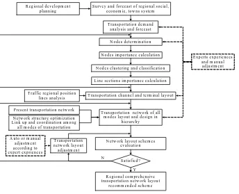
The planning flow of comprehensive transportation network layout is on the basis of the investigation and analysis of regional population, social economy, transportation demand, analyzing the nodes importance to determine the node level, thus further layout channels and hubs, then according to traffic flow of each modes to produce various network layout planning schemes [5]. Evaluate and compare whether the planning schemes are satisfied, or else return to above steps, until the recommended scheme is obtained in the end. The planning procedure of comprehensive transportation network is a systematic engineering. From collecting basic data to network layout planning scheme coming into being, it is involved in transportation demand forecast, nodes selection and classification, terminal nodes determination and positioning, channels direction determination and adjustment, layout of all kinds of transportation networks, and layout schemes evaluation, comparison and selection. The planning should consider current transport network and future layout development of regional cities and towns. These steps carrying on repeatedly until obtain satisfied result, shown in Fig. 1.
From the figure, it can be seen that some operations should be accomplished by computer, such as calculation of nodes importance, clustering analysis of nodes, automatic generation and adjustment of layout schemes, calculation of evaluation indexes. Because of participation of planning personnel, experts and decision-makers of different fields, so the system should provide basic functions of automatic layout as well as manual adjustment for users.
The system should be able to store relevant planning data, through the man-machine interaction and related models analyze node importance and channel layout, combining with the experts’ opinion give the transport network layout scheme. The system should provide the following functions:
T r a f f ic r e g io n a l p o s itio n lin e s a n a ly s is
T r a n s p o r ta tio n d e m a n d a n a ly s is a n d fo r e c a s t
N o d e s d e te r m in a tio n
N o d e s im p o r ta n c e c a lc u la tio n
N e tw o r k la y o u t s c h e m e s e v a lu a tio n
R e g io n a l c o m p r e h e n s iv e tr a n s p o r ta tio n n e tw o r k la y o u t
re c o m m e n d e d s c h e m e S u r v e y a n d f o r e c a s t o f r e g io n a l s o c ia l ,
e c o n o m ic , to w n s s y s te m
N o d e s c lu s te r in g a n d c la s s if ic a tio n
T r a n s p o r ta tio n n e tw o r k o f a ll m o d e s la y o u t a n d d e s ig n in
h ie r a r c h y
L in e s e c tio n s im p o r ta n c e c a lc u la tio n R e g io n a l d e v e lo p m e n t
p la n n in g
P r e s e n t tr a n s p o r ta tio n n e tw o r k
T r a n s p o r ta tio n c h a n n e l a n d te r m in a l la y o u t
N e tw o r k s tr u c tu r e o p tim iz a tio n L in k u p a n d c o o r d in a tio n a m o n g
a ll m o d e s o f tr a n s p o rta tio n
S a tis f ie d ? Y T r a n s p o r ta tio n
n e tw o r k la y o u t a d ju s tm e n t
N
E x p e r ts e x p e r ie n c e s a n d m a n u a l a d ju s tm e n t
[image:3.595.136.480.117.396.2]A u to o r m a n u a l a d ju s tm e n t a c c o r d in g to e x p e r t e x p r ie n c e s
Figure 1. Comprehensive transportation network layout planning procedure
(1) Implement the map management for visually showing the network layout process and result. (2) Demand analysis and forecast of various modes of transportation.
(3) Taking the node information as core, realize the dynamic management of node data and graphical display of nodes. Accomplish node importance calculation and clustering analysis to classify the node level, and calculate line sections importance. Manual management of node information is allowed.
(4) Combined with line sections importance and traffic demand forecast results, determine the direction of channels, which can be adjusted considering special requirements.
(5) Layout and manually adjustment of transportation network of all kinds of modes. It can generate some different network schemes according to different methods and goals.
(6) Different evaluation models can be chosen from the system for different network layout scheme to provide decision support for experts.
(7) Determine the scheme of network construction sequence according to lines adapting to transportation requirements.
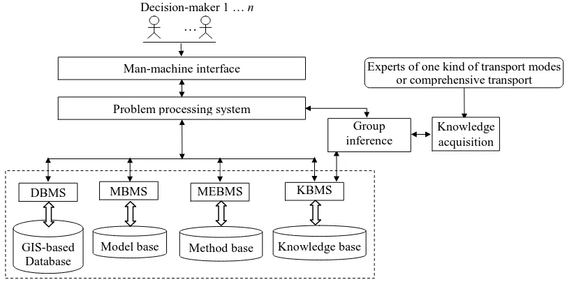
4. Structure design of the system A. General structure
Figure 2. Framework diagram of comprehensive transportation network layout planning IGDSS
The comprehensive transportation network planning IGDSS consists of database, model base, method base, knowledge base and their respective base management system. Decision-makers include experts familiar with certain or some of the modes of transportation and related domanial experts. The contents of each base in the system is illustrated as follows:
[image:4.595.102.508.72.274.2](1) Database. Because the system need to manage a large amount of different levels of spatial and non-spatial data and information, the GIS-based database is suggested, including attribute information such as society, economy, population, length of transportation lines, traffic volume, transport flow direction and transportation network linked with spatial information for convenient query, management, analysis, access and display. At the same time it should be able to save planning network layout schemes data of all kinds of transportation modes. The data of nodes, lines and zones of transport network are listed in Table 1. In addition, there are also present and future forecast data of economy and origin-destination transportation volume.
Table 1. Data contents of graphical elements of transportation network
Element Spatial data Attribute data
Node Coordinates
No., Name, Population, National income, GDP, Gross industrial output value, Gross agriculture output value, Total retail sales of social commodities, Passenger production, Passenger attraction, Passenger turnover, Freight production, Freight attraction, freight turnover, Importance degree
Line Start-point coordinates,
End-point coordinates No., Name, Mode type, Line grade, Length, Section importance
Zone Coordinates No., Name, Area, Transportation line mileage of all modes
(2) Model base. The model base includes all kinds of models of comprehensive transportation network planning, such as traffic volume forecast model, node importance calculation model, principal component analysis model, node clustering model, bi-level programming model of determining the scale of network [13], modal split model, channel and terminal layout model, network generation model, evaluation indexes calculation model, construction sequence evaluation model and so on. Input data, output data and parameters related to each models are defined. Users can select various corresponding models during every calculation.
(3) Method base. The method base provides network layout methods available, intelligent algorithm such as node clustering method, genetic algorithm, ant colony algorithm, simulated annealing algorithm, etc., and the comprehensive transportation network layout method, channel and terminal layout method, rational network scale determination method, optimized importance tree method, comprehensive evaluation methods such as the fuzzy evaluation, AHP, the matter element analysis, the hierarchical-gray correlation analysis method, etc. In addition, also includes group inference methods, such as group AHP, group qualitative reasoning, reasoning method based on rough set, etc.
(4) Knowledge base. The knowledge base mainly stores experts knowledge and experiences and knowledge induced
GIS-based Database
DBMS MEBMS
Decision-maker 1 … n
Experts of one kind of transport modes or comprehensive transport
Knowledge base KBMS Man-machine interface
Problem processing system
Model base
…
MBMS
Method base
Group inference
economic development requirements, development trend of all the kinds of transportation mode, connective requirements in one mode and between modes and so on, which makes the system have a certain degree of analysis ability to support the problem solving.
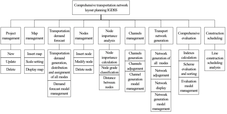
B. Modules design
The system adopts modular design. According to above analysis, the composition of subsystems of this system is shown in Fig. 3. Every subsystem realizes independent function. The subsystems denote comprehensive transportation network layout planning stages or steps respectively. The detailed description of the function of each module is illustrated as follows:
Comprehensive transportation network layout planning IGDSS
Project management Map management Transportation demand forecast Nodes management Node importance analysis Channels management Transport network generation Comprehensive evaluation Construction scheduling New Update Delete Insert map Scale setting Display map Demand forecast model management Transportation demand generation, distribution and assignment
of all modes
Insert node Modify node Delete node Node importance calculation Node grade classification Distance between nodes Channels generation Channels adjugement Channel generation model management Network generation of
[image:5.595.112.502.187.384.2]all modes Network adjugement Netwoek generation model management Network display Indexes calculation Scheme evaluation and sorting Evaluation model management Line construction scheduling analysis
Figure 3. Subsystem structure of comprehensive network layout planning IGDSS
(1) Project management subsystem. The function of project management is realizing to create new project, update project data, delete project and select present work project.
(2) Map management subsystem. The function of map management is to realize loading the map, scale setting, map display, and display of node, channel and network layout scheme of all transport modes.
(3) Transportation demand forecast subsystem. The function of the subsystem is to analyze current transport data and forecast the future traffic demand OD in the area, find out the total traffic demand and split demand, complete traffic distribution and assignment, which is the foundation of network layout. This part can be connected with the mature planning software such as TransCAD.
(4) Nodes management subsystem. The function of nodes management is to realize the node data management, which provides operations of draw node, and input, update, delete node data. Draw nodes and input corresponding data in open dialog box, the nodes can be displayed in the map. Nodes information is basic data for network layout planning, the following operations are carried on around these logical nodes.
(5) Node importance analysis subsystem. The function of node importance analysis is to calculate node importance value and classify the nodes. It can query importance of every node and which grade it belonging to. The node classification grade can be adjusted on requirement. The module can also calculate the distance between pairs of nodes and line sections importance degree.
(6) Channel management subsystem. The provided function of channel management can automatically generate comprehensive transportation channel direction and link between nodes that also can be manually adjusted such as added, deleted, modified, and shown in the map.
(7) Network generation subsystem. According to the split of the passenger and freight traffic volume, automatically generate the network of various transportation modes, which can be manual adjusted. Different mode of transportation network is stored in different map layer. Form several schemes to be compared and selected.
(8) Comprehensive evaluation subsystem. The function of comprehensive evaluation is to evaluate and analyze the comprehensive transportation network layout scheme, and sort the schemes. It can manage evaluation indexes. The system provides some default evaluation indexes. The user can also choose, redefine, add or delete them. It can choose any of comprehensive evaluation method provided in the system to evaluate schemes, and show final comparison results as decision basis.
The system offers backing operation, returning to backward step, and the following data will update along with the modification.
C. System processing flow
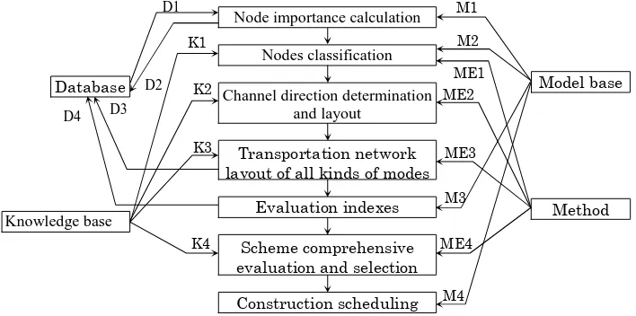
[image:6.595.130.484.165.341.2]After start the system and create a project, on the basis of transportation demand data, the process of solving the planning problem of comprehensive transportation network layout and data exchange among modules is shown in Fig. 4. The symbols of data flow in the figure are illustrated as follows:
Figure 4. System processing flow and data transmitting
(1) D denotes data exchanged with database. D1 is the node data, including node number, node name, node coordinates, social and economic data, transportation lines mileage, passengers and freight transportation volume and turnover, and so on; D2 is the node importance data, including node number, node importance degree and node classification grade; D3 is the transportation network data, including network layout scheme number and network layout graph; D4 is the data of evaluation indexes calculation result of layout schemes, including network layout scheme number, evaluation index value and comprehensive evaluation value of layout scheme.
(2) K denotes data exchanged with knowledge base. K1 is the principles of nodes classification; K2 is the principles and knowledge of channel determination; K3 is the principles of five transportation network planning; K4 is knowledge of evaluation and selection.
(3) M denotes data exchanged with model base. M1 is the model of node importance calculation; M2 is the nodes clustering analysis model; M3 is the model of all indexes calculation; M4 is the model of construction sequence determination of network.
(4) ME denotes data exchanged with method base. ME1 is the method to solve nodes clustering analysis model; ME2 is the method of channel layout; ME3 is the method of network layout; ME4 is the comprehensive evaluation method of planning schemes.
In the layout optimization process, the input data include basic social and economic data, and transportation data; the output data are network layout scheme of all transportation modes and comprehensive evaluation value.
5. Group decision-making and scheme selection mechanism
Comprehensive transportation network planning is a very complicated problem, and complicated problem decision must rely on the wisdom of the group. Each decision expert may be a certain field experts in railway, highway, aviation, waterway or pipeline, or is the same field but different views. Just because of the very big difference in their structure of knowledge, experience, way of thinking, decision-making preferences and look at the point of view of the problem, the given inference rules to the same network layout decision problem are not the same. These rules are compatible or not, so the conclusion may be different. Group inference system can use the knowledge base to integrate more experts knowledge and experience, adopt appropriate reasoning algorithm to solve the comprehensive transportation network layout problem, in order to improve the intelligent level of the system, at the same time, can produce new knowledge to dynamically update knowledge base. Quantitative analysis and with expert knowledge will make network layout scheme more scientific and reasonable.
Decision of layout scheme ultimately land on the evaluation of plan. For technique evaluation of comprehensive transportation network layout schemes, constructs eight indexes, namely transport network connectivity c1,
transportation network reachability c2, line efficiency c3, transport network adaptability c4, line saturation degree c5, Node importance calculation
Nodes classification
Channel direction determination and layout
Transportation network layout of all kinds of modes
Evaluation indexes calculation Scheme comprehensive evaluation and selection
Construction scheduling Database
Knowledge base
Model base
Method base
D1 M1
K1
K2
K3 D3
K4
M2
ME1
M3
M4 ME2
ME3
ME4 D4
and meeting the demand situation of the transport network. With applying group fuzzy evaluation decision method [14], there are n decision-makers {d1, d2, ... , dn} to evaluate m possible planning schemes A = {a1, a2, ... , am}. Each decision-maker will be based on their choice of attributes {c1 and c2, ..., cp} for each independent evaluation scheme. Here ci is the ith evaluation index of above. {w1, w2, ... , wp} denotes each attribute importance, {ω1, ω2, …, ωn} denotes decision-maker’s personal evaluation of relative importance. Decision-makers may use the different scheme evaluation indexes and different weights, so it need aggregate all the individual evaluation results.
The steps of sorting and selecting schemes are:
(1) Standardize the fuzzy judgment matrix k m p ij k a
× =(~ ) ~
A according to index different type, which consist of schemes and their subjection degree of relative attributes, where a~ij∈[0,1] denotes the jth index subjection degree of the ith scheme, k =1, …, n denotes the kth decision-maker. The cost index, effectiveness index and fixed index are standardized respectively: 7 5 ), 8 . 0 | 8 . 0 | exp( , 4 , 3 , 1 ), max exp( 1 8 , 6 , 2 ), max exp( ~ = − − = − − = − = j a j a a j a a a ij ij ij ij ij ij (1)
(2) Construct fuzzy complementary matrix Rk =(rijk)p×paccording to different decision-maker pairwise comparing the importance of evaluation indexes, then convert it to fuzzy consistent matrix [15], i.e. to any l, there is:
5
.
0
+
−
=
il jlij
r
r
r
(2)The convert method is:
)
(
,
5
.
0
2
/
)
(
1∑
−=
+
−
=
p j ij i j iij
r
r
p
r
r
r
(3)(3) Calculate the priority vector
(
1,
2,
,
kp)
kk
k
=
w
w
L
w
w
according toR
k for different fussy consistent matrix with applying eigenvalue method.(4) To every scheme, apply WAA operator to integrate the indexes subjection degree. Let
µ
Bk~i denotes the possible degree of scheme ai regarded as the best choice from A, then:( )
= = ⋅ =∑
= × p j k ij k j m k i B T k kk w a
1 1 ~ ~ ) ~ ( ~
µ
A wB , (i=1, …, m) (4)
(5) Combine different decision-maker’s evaluation result:
∑
==
n k k i B k i B 1 ~~
ω
µ
µ
(5)(6) Sorting the m schemes according to the comprehensive subjection degree. The maximum subjection degree, )
( max ~ i
i B A
ai a
µ
∈ will be selected for the best solution as a recommended scheme.
S t a r t
I n p u t f u z z y c o m p l e m e n t a r y m a t r i x Rk
C a l c u l a t e i n d e x w e i g h t wk
S e l e c t e v a l u a t e i n d e x e s
A g g r e g a t e s o r t i n g v e c t o r
k = n?
E n d
k = k + 1
D e t e r m i n e n u m b e r o f d e c i s i o n - m a k e r n a n d ωk
Y
O u t p u t s o r t i n g r e s u l t o f s c h e m e s
k = 1
C a l c u l a t e s u b j e c t i o n d e g r e e o f s h e m e s B~k
N
D e t e r m i n e f u z z y j u d g e m e n t m a t r i xA~k
Figure 5. Flow chart of scheme evaluation and decision process
If the decision-makers use uniform evaluation indexes and index weights, it can firstly aggregate indexes value of different experts, and then convert it to single decision problem of multiple attributes. While if they use different evaluation indexes and weights, it should solve the schemes sorting decision problem in respectively and integrate the results of different experts.
CONCLUSION
To solve the actual comprehensive transportation network planning problems should rely on professional knowledge in addition to quantitative calculation. Establishing standardized and unified sharing comprehensive information database and knowledge system, and in decision considering different experts’ opinions become inevitable. The paper proposes constructing IGDSS for comprehensive transportation network planning and analyzes the composition and functions. The system should be able to long time failure-free operation, using graphical interface operation mode, give full consideration to the future needs to modify, and adopt modular design to avoid mass program modification when demand changes. Because of a large amount of data, the system should ensure preferable fault freedom, which should can check the input data and calculation result. The system will provide efficient and quality decision support for comprehensive transportation planning. In the system, the knowledge representation of planning expert and generation of inference rules are very important and also difficult. More evaluation and decision inference model and method to be provided need further research.
REFERENCES
![Synthesis and antibacterial activity of 3-amino-6-iodo-2-methyl quinazolin 4-(3H)-one and 6-iodo-2-methyl-4H-benzo [D] [1, 3] oxazin-4-one](data:image/gif;base64,R0lGODlhAQABAIAAAP///wAAACH5BAEAAAAALAAAAAABAAEAAAICRAEAOw==)