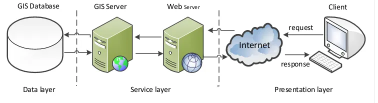
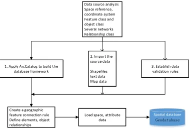
Application of WebGIS Technology in Information Management of Agricultural Science and Technology Park
Full text
Figure


Related documents
The aim of the study was to measure behavioral data (such as eye and head movements) and to assess how the two age groups differ in terms of number of safe street crossings,
There are seven leadership skills that a good project manager possesses; communication skills, problem solving and decision making skills, team building skills,
3 principle of legal certainty ?; (2) How to prioritize the division of bankrupt debtors' assets against preferred and separatist creditors according to the
The Best Practices of High Performing Sales Teams article series will focus on sales best practices that tend to be predictors of success in sales leadership/management,
Interestingly, 9 documents (more than those making reference to professional boundaries) discussed the potential benefits and opportunities of social media (NCSBN, n.d; NCSBN,
UEFA club competition: These are the official statistics considered valid for communicating official records in UEFA club competition defined as the European Champion Clubs' Cup,
Which of the following words cannot be formed from the letters of the given
Methods: This was a cross sectional study in which we determined foetal haemoglobin levels and examined the relationship between HbF levels and disease severity in SCA patients
