Natural Resources Conservation Service
Ecological site R062XY043SD
Valley Loam
Accessed: 01/23/2021
General information
Figure 1. Mapped extent
MLRA notes
Classification relationships
Ecological site concept
Provisional. A provisional ecological site description has undergone quality control and quality assurance review. It contains a working state and transition model and enough information to identify the ecological site.
Areas shown in blue indicate the maximum mapped extent of this ecological site. Other ecological sites likely occur within the highlighted areas. It is also possible for this ecological site to occur outside of highlighted areas if detailed soil survey has not been completed or recently updated.
Major Land Resource Area (MLRA): 062X–Black Hills
The Black Hills, MLRA 62, is a unique, low-lying mountain range situated in the midst of a mixed short- to mid-grass prairie. It has geophysical and biological attributes that are unlike the surrounding area. The Black Hills Foothills, which makes up MLRA 61, is a transition zone that essentially rings the Black Hills. MLRA 62 is approximately 3,040 square miles in size, 74 percent of which is located in South Dakota and 26 percent in Wyoming.
Land Resource Region (LRR): G - Western Great Plains Range and Irrigated Region, MLRA: 62 - Black Hills (USDA, NRCS. Ag Handbook 296).
Level IV Ecoregions of the Conterminous United States, 2013: 17b Black Hills Plateau.
This site is located in flat “V-” or “U-” shaped mountain valleys within the Black Hills. It is not an overflow site but can receive some additional moisture from runoff from adjacent forested sites. The slopes range from 0 to 10 percent. Soils are deep (> 16” surface layer), well drained loam and silty loam. This site occurs throughout the MLRA, but the
Associated sites
Similar sites
Table 1. Dominant plant species
climate tends to be cooler and wetter in the north and higher elevations than in the south where it is warmer and dryer. Vegetation in the Reference community consists of nearly equal proportions of cool- and warm-season grass species, and forbs are common and diverse but never dominant. A patchy mosaic of shrubs such as western snowberry are almost always present across this ecological site, and aspen clones are common along the margins with forested sites.
R062XB020SD
R062XC020SD
R062XA020SD
R062XB010SD
Stony Overflow
The Stony Overflow site (LRU-B) can be located adjacent to the Valley Loam site however the overflow site is directly influenced by addition water.
Loamy Overflow - South (LRU-C)
The Loamy Overflow site (LRU-C) can be located adjacent to the Valley Loam site however the overflow site is directly influenced by addition water.
Loamy Overflow - North (LRU-A)
The Loamy Overflow site (LRU-A) can be located adjacent to the Valley Loam site however the overflow site is directly influenced by addition water.
Loamy - High Central (LRU-B)
The Loam site (LRU-B) is located in Mountain Valleys that are dissected by low hills and hills slopes.
R062XA020SD R062XB010SD
R062XC020SD
Loamy Overflow - North (LRU-A)
The Loamy Overflow site (LRU-A) will have higher production and is located adjacent to water.
Loamy - High Central (LRU-B)
The Loam site (LRU-B) typically has a shallower soil surface layer, < 16 inch in depth, is located in Mountain Valleys that are dissected with low hills and hillslopes. The plant community has more cool-season grasses and few warm-cool-season grasses and lower production.
Loamy Overflow - South (LRU-C)
The Loamy Overflow site (LRU-C) will have higher production and is located adjacent to water.
Tree Shrub Herbaceous Not specified (1) Symphoricarpos occidentalis (1) Andropogon gerardii (2) Pascopyrum smithii
Physiographic features
Table 2. Representative physiographic features
This site occurs on nearly level to sloping mountain valley landscapes in the Black Hills. The Mt Valley shape range from a flat "V" shape to a "U" shape, which is linear or slightly concave.
Landforms (1) Mountain valley Flooding frequency None
Ponding frequency None
Elevation 3,800–7,000 ft
Slope 0–10%
Water table depth 80 in
Climatic features
Table 3. Representative climatic features
Climate stations used
MLRA 62 is in a microclimate caused by the influence of increased elevation, which leads to increased
precipitation, moderate air temperature, and lower wind velocities as compared to the surrounding Great Plains. In general, the Black Hills climate is a continental type, cold in the winter and hot in the summer. Annual precipitation in MLRA 62 typically increases with elevation and decreases from west to east and north to south. The average annual precipitation range for MLRA 62 is 17 to 35 inches: Land Resource Unit (LRU)-A (North) is 22 to 30 inches, LRU-B (Central High Country) is 25 to 35 inches and LRU-C (South) is 17 to 21 inches. Most of the rainfall occurs as frontal storms early in the growing season, inMay and June. Some high-intensity, convective thunderstorms occur in July and August. Precipitation in the winter occurs mostly as snow.
The annual average snowfall ranges from 23 inches at the lower elevations in the south to 54 inches at the higher elevations in the central part of MLRA 62. Average annual temperature ranges from 36 to 48 degrees F. January is the coldest month, with an average temperature of 22°F in the central part and 25°F in the southern part of MLRA 62. July is the warmest month, with an average daily temperature of 67°F in the central part and 73 F in the southern part of this MLRA. The frost-free period ranges from 129 to 168 days. It is shortest at higher elevations and in the northwestern part of the MLRA. Hourly winds are estimated to average about 11 miles per hour (mph) annually. Growth of cool-season plants begins in April, slowing or ceasing growth by mid-August. Warm-season plants begin growth in May, and continue to mid-September. Regrowth of cool-season plants may occur in September and October, depending upon soil moisture availability.
Frost-free period (average) 104 days Freeze-free period (average) 125 days Precipitation total (average) 21 in
(1) WIND CAVE [USC00399347], Buffalo Gap, SD (2) SUNDANCE [USC00488705], Sundance, WY (3) DEERFIELD 3 SE [USC00392231], Hill City, SD (4) CUSTER [USC00392087], Custer, SD
Influencing water features
This site occurs in valley landscapes, some of which have intermittent or perennial streams. This site will typically receive additional runoff from adjacent uplands, but is not influenced by streams or wetlands.
Soil features
The soils on this site are very deep and well drained. The surface layer is at least 16 inches thick, and commonly is deeper than 30 inches. Surface and subsurface textures are loamy (specific textures are listed below). The soils typically lack calcium carbonate above 40 inches. The slopes are typically 0 to 10 percent, but may range to 15 percent in a few areas.
Areas where slopes are less than about 3 percent typically are depositional areas. Unless the site is disturbed, the rate of deposition is roughly equal to or slightly greater than the rate of erosion. Water erosion is the primary hazard on this site. Erosion normally is minimal on slopes of less than 6 percent, and occurs primarily in the form of sheet erosion when present. Sheet and rill erosion are hazards on slopes greater than 6 percent. Although not common, gully erosion can become a hazard in areas of extreme disturbance, especially in areas of concentrated flow where slopes exceed 4 or 5 percent. Loss of 50 percent or more of the surface layer of the soils on this site can result in a shift in species composition and/or production. Although the soils on this site normally are not susceptible to significant wind erosion, site disturbances can increase the hazard locally.
Figure 6. Cordeston soil profile (cm) Table 4. Representative soil features
Access Web Soil Survey (http://websoilsurvey.nrcs.usda.gov/app/) for specific local soils information.
Parent material (1) Alluvium–limestone and sandstone Surface texture
Family particle size
Drainage class Well drained
Permeability class Moderate
Soil depth 40–60 in
Surface fragment cover <=3" 0–1% Surface fragment cover >3" 0–1% Available water capacity
(0-40in)
6–9 in Calcium carbonate equivalent
(0-40in)
0% Electrical conductivity
(0-40in)
0–2 mmhos/cm Sodium adsorption ratio
(0-40in)
0–1 Soil reaction (1:1 water)
(0-40in)
5.6–7.8 Subsurface fragment volume <=3"
(Depth not specified)
1–15% Subsurface fragment volume >3"
(Depth not specified)
0–1% (1) Loam (2) Sandy loam (1) Loamy
Ecological dynamics
Black Hills vegetation types consist of a mixture of forest and grasslands resulting from the varied topography, geology, soils, climate, and natural disturbances. Frequent fires, periodic drought, and episodic infestations of mountain pine beetles all contribute to the maintenance of large, open grasslands scattered throughout the Black Hills. Ponderosa pine is the dominant tree species in the Black Hills. It is a fire-adapted species that coexists with frequent, low-intensity fires that consume small seedlings, prune lower branches from larger trees, and reduce fuel loads on the forest floor. This site developed under Black Hills climatic conditions with short-term weather
State and transition model
of light intensities); and other biotic and abiotic factors that typically influence soil/site development. The natural fire regime maintained this site as a grassland and the plant communities were free of non-native cool-season grasses. Fire, or the lack of fire, and introduced non-native cool-season grasses, are major drivers, along with grazing and haying, that shape this site as well as adjacent ecological sites. The Valley Loamy site does not appear to be as susceptible to conifer encroachment as other “upland” Loamy sites in MLRA 62, but it can occur. Aspen commonly occur along the margins of this site, adjacent to forested sites. Kentucky bluegrass, timothy, and smooth brome are common cool-season grass species throughout MLRA 62. Because the Black Hills have higher precipitation amounts and have cooler spring and fall periods, non-native cool-season grasses can easily become established and become the dominant species on this site.
The Reference State illustrates what is thought to have existed prior to European settlement. It is very difficult to locate a Reference plant community due to the introduction and spread of non-native cool-season grasses. Plant community phase 2.1 is most similar to the Reference State, but because of the persistence of non-native cool-season grasses, a restoration pathway to the Reference State is not believed to be achievable.
The following diagram illustrates the common plant community phases that can occur on the site, and the transition pathways between communities. These are the most common plant community phases based on current
knowledge and experience, and changes will be made as more data is collected. Narratives following the diagram contain more detail pertaining to the ecological processes.
Figure 8. Valley Loam - 062XY043SD
State 1
Reference State
Community 1.1
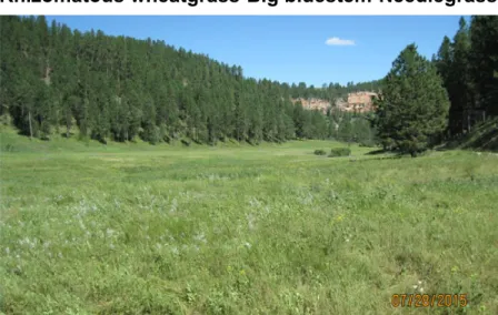
Big bluestem- Rhizomatous wheatgrass-Needlegrass/Mixed Shrubs
Community 1.2
This state represents what is believed to represent the natural range of variability and plant community dynamics of this ecological site prior to European settlement. The Reference State is unlikely to occur with the introduction of non-native cool-season grasses, which are common throughout the MLRA. This site was dominated by nearly equal portions of cool- and warm-season grasses, a diverse forb component, and various shrubs. In pre-European
settlement times, the primary disturbances included fire and grazing by large ungulates and small mammals. Favorable growing conditions occurred during the spring, and the warm months of June and July. Routine and/or occasional fires removed pine encroachment, and contributed to the ecological processes that maintained the Reference plant community.
Interpretations are primarily based upon the Big bluestem-Rhizomatous wheatgrass-Needlegrass/Mixed Shrubs plant community phase. This also is considered to be the Reference or historic plant community. The potential vegetation is about 75 percent grass and grass-like plants, 15 percent forbs, and 10 percent shrubs. Total annual production for a normal growing year is approximately 3,000 lbs./Ac. The community has nearly equal percentages of cool-season and warm-season grasses. The dominant warm-season grasses are big bluestem, prairie dropseed, and switchgrass. The principal cool-season grasses include western wheatgrass, bearded wheatgrass, slender wheatgrass, green needlegrass, Columbia needlegrass, and needleandthread. Other grasses and grass-like include Indiangrass, prairie Junegrass, porcupine grass, threadleaf sedge, and Richardson’s sedge. Forbs include stiff sunflower, stiff goldenrod, lupine, American vetch, yarrow, prairie smoke, and prairie coneflower. The dominant shrubs are western snowberry, hawthorn, leadplant, and prairie rose. Aspen clones are common along the margin of the Valley Loam site adjacent to forested sites. This plant community was productive and resilient to disturbances such as drought and fire. It was a sustainable plant community in regard to soil/site stability, watershed function, and biological integrity.
Rhizomatous wheatgrass-Needlegrass/Mixed Shrubs
Pathway 1.1A
Community 1.1 to 1.2
Pathway 1.2A
Community 1.2 to 1.1
State 2
Native/Invaded State
Community 2.1
Rhizomatous wheatgrass-Big bluestem-Needlegrass-Bluegrass/Mixed Shrub
This plant community phase is the result of continuous season-long grazing without adequate recovery or continuous seasonal grazing during the early summer growing season every year. These grazing patterns will reduce the percentage of warm-season grasses and increase the percentage of cool-season grasses. Wet spring and fall precipitation patterns and dry summer months, in combination with grazing, can also cause a shift in the plant community toward a cool-season -dominated community. The removal of other natural disturbances, such as periodic fire and no-use, can cause a shift in the plant species to create a cool-season grass-dominated plant community. The potential vegetation consists of approximately 70 percent grasses and grass-likes, 15 percent forbs, and 15 percent shrubs and trees. The community is dominated by cool-season grasses, including western wheatgrass, bearded wheatgrass, slender wheatgrass, green needlegrass, needleandthread, and Columbia needlegrass. Warm-season grasses include big bluestem, prairie dropseed, and blue grama. Other grasses and grass-like plants in this phase include porcupine grass, prairie Junegrass, threadleaf sedge, and Richardson’s sedge. Forbs include goldenrod species, lupine, yarrow, prairie smoke, and prairie coneflower. Dominant shrubs include western snowberry, prairie rose, and hawthorn. Aspen clones are common along the margin of the Valley Loam site adjacent to forested sites. This plant community was productive and resilient to disturbances such as drought and fire. It’s a sustainable plant community in regard to soil/site stability, watershed function, and biological integrity.
Long-term moderate to heavy grazing pressure without adequate recovery time, extended periods of below normal precipitation, and/or fire followed with intensive grazing by livestock or wildlife can move this PCP 1.1 to PCP 1.2.
Grazing that provides adequate recovery, normal to above normal precipitation, and a normal fire regime without intensive grazing by livestock or wildlife can move PCP 1.2 back to PCP 1.1.
This state represents what is most typically found on this site. The natural range of variability is influenced by the presence of non-native cool-season grasses, especially smooth brome, Kentucky bluegrass, and timothy that can dominate the dynamics of this ecological site. Proper grazing management and periodic burning will maintain the productivity of this state. Heavy grazing without adequate recovery, excessive haying, and extended periods of non-use and no fire can put this state at risk of crossing a threshold to the Introduced/Invaded State.
Community 2.2
Rhizomatous wheatgrass-Bluegrass-Smooth brome/Weedy forbs/Mixed Shrubs
Pathway 2.1A
Community 2.1 to 2.2
Pathway 2.2A
Community 2.2 to 2.1
State 3
Introduced/Invaded State
This plant community phase closely resembles the PCP 1.1; however, non-native cool-season grasses have invaded the site and will persist in the plant community under the current Black Hills climatic conditions.
The potential vegetation consists of about 75 percent grass and grass-like plants, 15 percent forbs, and 10 percent shrubs and trees. Total annual production for a normal growing year is approximately 2,800 lbs./Ac. The community is dominated by cool-season grasses and tall and mid-height warm-season grasses. The dominant cool-season grasses include western and bearded wheatgrass, green needlegrass, needleandthread, and porcupine grass. Kentucky bluegrass and/or other non-native cool-season grasses can make up 2 to 5 percent of the plant
community. Dominant warm-season grasses are big bluestem, prairie dropseed, and switchgrass. Other grasses include slender wheatgrass, Richardson’s needlegrass, thread-leaf sedge, and Richardson’s sedge. The dominant shrubs are western snowberry, leadplant, hawthorn, and rose. This plant community is productive and resilient to disturbances such as drought and fire. It is a sustainable plant community in regard to soil/site stability, watershed function, and biological integrity. Management strategies must include techniques that will not cause Kentucky bluegrass and other non-native cool-season grasses to increase significantly, as this could put the plant community at risk of transition to the Introduced/Invaded State.
This plant community evolved under continuous season-long grazing, or seasonal grazing with no change in season of use, or no use and no fire, or heavy continuous grazing that exceeds carrying capacity, or excessive haying. This plant community phase is made up of approximately 85 percent grass and grass-like plants, 10 percent forbs, and 5 percent shrubs and trees. The community is dominated by cool-season grasses, with most of the warm-season grass component replaced by smooth brome and Kentucky bluegrass, along with other non-native cool-season grasses. The dominant cool-season grasses include western and bearded wheatgrass, Richardson’s needlegrass. Kentucky bluegrass or other non-native cool-season grasses can make up 10 to 20 percent of the plant community. Forbs may tend to be weedy and invasive. Common shrubs include western snowberry and green sagewort. This plant community is at risk of crossing a threshold to the Introduced/Invaded State.
Non-use and no fire and/or continuous season-long grazing or seasonal grazing occurring at the same time every year, or heavy continuous grazing or excessive haying will cause an increase in non-native cool-season grass species moving this plant community to PCP 2.2.
Prescribed grazing and forage harvest management that provided adequate recovery and change in season of use, along with normal precipitation regime and fire may reduce the percent of non-native cool-season grasses in PCP 2.2 and restore the tall warm-season component typical of PCP 2.1.
This state is the result of invasion and dominance of introduced species. This state is characterized by the dominance of smooth brome, Kentucky bluegrass, and timothy in the plant communities. These species will out-compete the native bluestems, needlegrasses, and wheatgrasses and replace them in the plant community. The nutrient cycle is impaired, which results in a higher level of nitrogen that favors the introduced species. Studies indicate that soil biological activity is altered, and this shift apparently exploits the soil microclimate and encourages growth of the introduced grass species. Once the threshold is crossed, a change in grazing management alone cannot cause a reduction in the invasive grass dominance. Preliminary studies indicate this threshold may exist when Kentucky bluegrass exceeds 30 percent of the plant community and native grasses represent less than 40 percent of the plant community composition. Plant communities dominated by Kentucky bluegrass have significantly less cover and diversity of native grasses and forb species. (Toledo, D. et al., 2014).
Community 3.1
Smooth brome-Kentucky bluegrass /Weedy forbs/Mixed Shrubs
State 4
Early Seral State
Community 4.1
Pioneer Perennial/Introduced Species, Bare Ground
Transition 1A
State 1 to 2
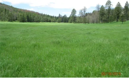
Figure 10. Valley Loam Plant Community Phase 3.1
This plant community is dominated by smooth brome, Kentucky bluegrass, and/or other non-native cool-season grasses making up 30 percent or more of the plant community. This plant community evolved under no use and no fire, or with heavy continuous season-long grazing, or seasonal grazing with no change in season of use, or excessive haying.
This plant community is made up of approximately 85 percent grasses and grass-like species, 10 percent forbs, and 5 percent shrubs. Dominant grasses include Kentucky bluegrass, smooth brome, and possibly timothy.
Rhizomatous wheatgrasses and some needlegrasses may still be found in the plant community. Forbs commonly found in this plant community include cudweed sagewort, goldenrod, and western ragweed. Production will be significantly reduced when compared to the interpretive plant community. The period when palatability is high is relatively short, as smooth brome and Kentucky bluegrass matures rapidly. Energy capture also is reduced. Runoff is high and biological activity in the soil likely is reduced significantly in this phase.
This state is the result of very heavy disturbance such as cropping, concentrated livestock feeding areas, or rodent activity. This state can develop as a result of invasion by highly competitive weed species such as Canada thistle, hound’s tongue, leafy spurge, or knapweeds. Heavy grazing also can push an at-risk plant community phase to this state. In most cases, this phase is dominated by annual and/or pioneer perennial species. The percentage of bare ground typically is much higher than on any other plant community phase.
This plant community developed under continuous heavy grazing or heavy disturbances such as heavy use areas, abandoned cropland, and livestock feeding areas. The potential plant community is made up of 60-80 percent grasses and grass-like species, 15 to 35 percent forbs, and 2 to 5 percent shrubs. The percentage of bare ground can be very high in this plant community. The dominant grass often is smooth brome and Kentucky bluegrass. Other grasses may include annual bromegrass (field brome and cheatgrass), sedge, sand dropseed, and western
wheatgrass. The dominant forbs include fetid marigold, sweetclover, western ragweed, cudweed sagewort, and other invasive species. The dominant shrubs include fringed sagewort and broom snakeweed. A wide variety of other early seral plant species can occupy this site in varying amounts. This plant community is susceptible to invasion of Canada thistle and other non-native species because of the relatively high percentage of bare ground.
Transition 2A
State 2 to 3
Transition 2B
State 2 to 4
Restoration pathway 3A
State 3 to 2
Transition 3A
State 3 to 4
Restoration pathway 4A
State 4 to 2
Transition 4A
State 4 to 3
disruption of natural disturbance regimes, typically as a result of fire suppression following settlement, led this state over a threshold to the Native/Introduced State 2.0.
Introduction or increase of non-native cool season grass species in the plant community. Non-use and no fire. Excessive haying of native grass species and or heavy continuous grazing. This transition is most likely going to occur from PCP 2.2
Severe and frequent defoliation, which can be exacerbated by drought and/or additional livestock or wildlife use. Heavy disturbance areas, including livestock feeding areas and cropping, also can cause this transition to the Early Seral State.
Early season prescribed burning followed by long term prescribed grazing to promote establishment of native species. Chemical and/or mechanical treatment followed by seeding of native species may accelerate the reestablishment of structural functional groups similar to PCP
2.1 , but the resulting plant community may not achieve management goals. This restoration pathway can take many years and may not be successful in the end.
Severe and frequent defoliation, livestock feeding, heavy disturbance, excessive haying and cropping will push this plant community to the Early Seral State.
Removal of severe grazing disturbance (frequency and intensity), normal precipitation and fire regime, and time. Chemical and/or mechanical treatment followed by seeding of native species may accelerate the reestablishment of structural/functional groups similar to PCP 2.1; however, the resulting plant community may not achieve
management goals. This restoration pathway can take many years and may not be successful in the end.
Removal of severe grazing disturbance (frequency and intensity) and normal precipitation regime. Chemical and/or mechanical treatment followed by seeding of native and/or introduced species can transition this plant community back to the Introduced/Invaded State.
Additional community tables
Other information
Revision Notes:
This PROVISIONAL ecological site concept has been QCd and QAd to ensure that the site meets the NESH standards for a provisional ecological site that provides basic compiled information in one location. This site should not be considered an Approved ESD, as it is only the foundational site concepts and requires further data collection —specifically high-intensity data characterizations and full 232 soil descriptions—and further site investigations and
final STM reviews before it can be used as an Approved ESD meeting NESH standards. This site is new to the MLRA but was previously included in the High Country Silty Range Site 062XY033SD in the South Dakota FOTG. Site Development and Testing Plan:
Future work, as described in a Project Plan, to validate the information in this Provisional Ecological Site Description is needed. This will include field activities to collect low-, medium-, and high-intensity sampling, soil correlations, and analysis of that data. Annual field reviews should be done by soil scientists and vegetation specialists. A final field review, peer review, quality control, and quality assurance reviews of the ESD will be needed to produce the final document.
Inventory data references
Other references
Contributors
Information presented here has been derived from NRCS clipping data and other inventory data. Field observations from range-trained personnel were also used. Those involved in developing this site include: Lakhdar Benkobi, ESI/SRIC, NRCS; Stan Boltz, Range Management Specialist, NRCS; Dan Brady, Soil Scientist, NRCS; Mitch Faulkner, Range Management Specialist, NRCS; Roger Gates, Associate Professor/Rangeland Management Specialist, West River Ag Center; Rick Peterson, Ecological Site Specialist, NRCS; Matthew, Scott, Botanist -USFS Hell Canyon District Ranger; L. Michael Stirling, Range Management Specialist, NRCS; Jim Westerman, Soil Scientist, NRCS.
High Plains Regional Climate Center, University of Nebraska. http://www.hprcc.unl.edu/)
Toledo, D., M. Sanderson, K. Spaeth., J. Hendrickson, J. Printz. 2014. Extent of Kentucky bluegrass and its effect on native plant species diversity and ecosystem services in the Northern Great Plains of the United States. Invasive Plant Science and Management. 7(4):543-522. Weed Science Society of America.
USDS, NRCS. 2006. Land Resource Regions and Major Land Resource Areas of the United States, the Caribbean, and the Pacific Basin. U.S. Department of Agriculture Handbook 296.
USDA, NRCS. National Water and Climate Center. (http://wcc.nrcs.usda.gov) USDA, NRCS. National Range and Pasture Handbook. September, 1997
USDA, NRCS. National Soil Information System, Information Technology Center. (http://nasis.nrcs.usda.gov) USDA, NRCS. 2001. The PLANTS Database, Version 3.1 (http://plants.usda.gov). National Plant Data Center. USDA, NRCS. National Ecological Site Handbook. 1st Ed, January, 2014.
Peterson Rick L. Westerman James
Rangeland health reference sheet
Interpreting Indicators of Rangeland Health is a qualitative assessment protocol used to determine ecosystem condition based on benchmark characteristics described in the Reference Sheet. A suite of 17 (or more) indicators are typically considered in an assessment. The ecological site(s) representative of an assessment location must be known prior to applying the protocol and must be verified based on soils and climate. Current plant community cannot be used to identify the ecological site.
Indicators
1. Number and extent of rills:
2. Presence of water flow patterns:
3. Number and height of erosional pedestals or terracettes:
4. Bare ground from Ecological Site Description or other studies (rock, litter, lichen, moss, plant canopy are not
bare ground):
5. Number of gullies and erosion associated with gullies:
6. Extent of wind scoured, blowouts and/or depositional areas:
7. Amount of litter movement (describe size and distance expected to travel):
8. Soil surface (top few mm) resistance to erosion (stability values are averages - most sites will show a range of
values):
9. Soil surface structure and SOM content (include type of structure and A-horizon color and thickness):
10. Effect of community phase composition (relative proportion of different functional groups) and spatial
distribution on infiltration and runoff:
11. Presence and thickness of compaction layer (usually none; describe soil profile features which may be
mistaken for compaction on this site):
12. Functional/Structural Groups (list in order of descending dominance by above-ground annual-production or live
foliar cover using symbols: >>, >, = to indicate much greater than, greater than, and equal to):
Contact for lead author Date
Approved by Approval date
Dominant: Sub-dominant: Other:
Additional:
13. Amount of plant mortality and decadence (include which functional groups are expected to show mortality or
decadence):
14. Average percent litter cover (%) and depth ( in):
15. Expected annual production (this is TOTAL above-ground production, not just forage
annual-production):
16. Potential invasive (including noxious) species (native and non-native). List species which BOTH characterize
degraded states and have the potential to become a dominant or co-dominant species on the ecological site if their future establishment and growth is not actively controlled by management interventions. Species that become dominant for only one to several years (e.g., short-term response to drought or wildfire) are not