AN ASSESSMENT FRAMEWORK FOR WALKABILITY IN
LIBYAN CITY CENTRES: PUBLIC SPACES IN TRIPOLI
KHAIRI MOHAMED ALBASHIR ABDULLA
A thesis submitted in partial fulfilment of the requirements of
Nottingham Trent University for the degree of Doctor of Philosophy
Copyright Statement
This work is the intellectual property of the author. You may copy up to 5% of this work for
private study, or personal, non-commercial research. Any re-use of the information
contained within this document should be fully referenced, quoting the author, title,
university, degree level and pagination. Queries or requests for any other use, or if a more
substantial copy is required, should be directed in the owner(s) of the Intellectual Property
Abstract
Libyan civic and urban centres are increasingly suffering from unwalkable places due to the
lack of legislation for accessibility, multiplication of unregulated car traffic, and the absence
of adequate urban and spatial planning. In the last few decades, there has been an increasing
interest in the field of walkable public open space as a key driver of sustainable urban
development and redistribution of land use, to ensure pedestrian and walkable routes
between sites of living and workplaces, and to reduce dependence on automobiles. However,
in most developing countries, including Libya, there is limited a comprehensive approach
and framework to enable and facilitate walkable public open spaces in urban centres.
This research analyses factors and identifies barriers related to walkability in public open
spaces in Tripoli (Libya) in two phases: exploring the consistency and validity of effective
walkability factors related to the context, using surveys with 25 Libyan specialists, experts,
and decision makers; and developing a mixed methodological approach to assess and
evaluate current perceptions, attitudes, and aspects involved in determining what makes an
accessible and walkable urban space in Tripoli. The empirical study included analysis of a
questionnaire survey (using SPSS version 20.0) of 427 users and 108 professionals, and
observation of spatial practices and attitudes in four different public spaces in the city.
Focus group discussions were used to validate the results, which showed that safety and
security; lack of facilities, and physical barriers; institutional, legislative, management and
financial barriers; social and cultural barriers; and transportation system barriers, with
varying weights, hinder people’s decisions to walk in public open spaces in Tripoli. A
framework was developed to assess the significance and extent of these walkability problems
that can be used as a basis for public open space making and management in developing countries’ urban planning.
To:
My father, Mohamed and mother, Fatima
My wife, Noura
My daughters, Robeen and Roaa
My sons, Abdalmoaz and Abdalmuhaymin
My supervisor, Prof. Mohamed Gamal Abdelmonem
My brothers and sisters
Acknowledgements
Foremost, I am extremely thankful to Allah (Almighty God), for without his mercy and
beneficence, I would not be successful in achieving my goals. There are so many people
that have contributed to reach this point and make it possible to finish my thesis.
My first debt of gratitude must go to my supervisor Prof. Mohamed Gamal, for his continued
invaluable guidance and inspiration. Dr Gamal has encouraged me through the PhD period.
I cannot thank you enough for your patience and encouragement. My sincere thanks, respect
and appreciations also go to my second supervisor Dr Gehan Selim.
I must thank my parents, wife, children, brothers, sisters and friends for their prayers, hearty
support, encouragements and being patient throughout the long journey of my research.
To my beloved country, Libya, which granted me this opportunity to be here and to develop
and expand my knowledge in my field and also in several other areas. I ask Allah to protect
Table of Contents
COPYRIGHT STATEMENT ... II
ABSTRACT ... III
ACKNOWLEDGEMENTS ... V
LIST OF FIGURES ... XV
LIST OF TABLES ... XIX
LIST OF ABBREVIATIONS ... XXIII
LIST OF PUBLICATIONS ... XXIV
CHAPTER 1INTRODUCTION ... 1
1.1 Problem statement ... 3
1.2 Lack of walkability assessment tools for Libyan city centres ... 7
1.3 Safety and security issues in Tripoli ... 9
1.4 Research question ... 9
1.5 Research aim and objectives ... 9
1.6 Research methodology ... 10
Overview ... 10
Phase one: Delphi method ... 11
Phase two ... 11
1.6.3.1 Questionnaire surveys ... 11
1.6.3.2 Fieldwork and observation ... 11
1.6.3.3 Focus group discussions ... 12
1.7 Structure of the thesis... 12
CHAPTER 2OVERVIEW OF PUBLIC OPEN SPACES ... 15
2.1 Definition of public open space ... 15
2.2 Characteristics of public open space ... 17
Social use of public open space ... 18
Public open space for everyone... 20
User needs in public open space ... 21
2.4 Typologies of public open space... 21
2.5 Streets as public open spaces in Tripoli ... 23
Street as social space ... 26
Street as pedestrian pathway ... 26
Commercial space ... 27
Street as cultural space ... 28
2.6 Squares as public open spaces ... 29
2.7 Dimensions of urban open spaces ... 31
Social dimensions of urban open spaces ... 32
Visual dimensions of urban open spaces ... 33
Functional dimensions of urban open spaces ... 33
2.8 Public open spaces in Libya ... 34
2.9 Summary ... 40
CHAPTER 3AN OVERVIEW OF A WALKABLE PUBLIC OPEN SPACE ... 41
3.1 Definition ... 41
3.2 Types of walking purposes ... 43
Transportation ... 43
Pleasure, leisure, and recreation ... 45
3.3 Walkability in developed cities ... 46
3.4 Walkability in developing cities ... 51
3.5 Walkability in Libyan cities ... 51
3.6 Measuring walkability ... 52
Subjective measurements ... 53
Walkability measurement factors ... 53
3.7 Factors of walkable open spaces ... 59
Accessibility ... 60
Comfortability ... 61
Safety and security ... 63
Pavement ... 64
Mixed land use ... 66
City centre activity ... 67
3.8 Summary ... 69
CHAPTER 4RESEARCH METHODOLOGY ... 72
4.1 Research approach, data collection and analysis ... 72
4.2 Phase 1: Determine the general factors influencing users’ decisions to spend time walking and revisiting the POS in Tripoli ... 76
Reliability in Delphi method ... 76
Level of expert consensus ... 77
Selection of Delphi panel ... 78
Case studies suggested ... 78
Data analysis for Phase 1 ... 80
4.3 Phase 2: Mixed methods ... 81
User and Professional Questionnaire Survey ... 81
4.3.1.1 Developing and piloting the questionnaires ... 82
4.3.1.2 Sample size determination ... 83
4.3.1.3 Data analysis for User and Professional Questionnaire Surveys ... 84
Observation ... 87
Focus group discussion (FGD)... 90
Validity and reliability ... 92
4.4 Summary ... 95
CHAPTER 5PHASE 1: DETERMINING GENERAL FACTORS IN USERS SPENDING TIME WALKING AND REVISITING TRIPOLI’S POS ... 96
5.1 Overview ... 96
Delphi technique ... 96
Profile of respondents ... 97
Level of expert consensus ... 100
5.2 Round one analysis ... 101
Factors of socio-demographic indicators ... 101
Factors of mixed land use diversity ... 102
Factors of accessibility ... 103
Factors of company ... 104
Factors of pedestrian facilities ... 105
Factors of convenience and comfort ... 106
Factors of safety and security ... 107
Factors of aesthetics ... 109
Case study selection ... 110
5.3 Round two analysis ... 112
Factors of socio-demographic ... 113
Factors of mixed land use ... 114
Factors of accessibility ... 115
Factors of pedestrian facilities ... 117
Factors of convenience and comfort ... 118
Factors of safety and security ... 120
Factors of aesthetics ... 121
Case study selection round two ... 122
CHAPTER 6PHASE 2: USERS’ PERCEPTIONS OF PUBLIC OPEN SPACES –
QUESTIONNAIRE ANALYSIS ... 126
6.1 User questionnaire analysis... 126
Case study rating ... 126
Case study areas and time spent in walking ... 127
Gender and time spent in walking ... 128
Age and time spent in walking ... 131
Education and time spent in walking ... 133
Case study areas and revisiting POS ... 135
Gender and revisiting POS ... 137
Age and revisiting POS ... 139
Education and revisiting POS ... 141
Main barriers prevent users to spend time for walk and revisiting POS .. 143
6.1.10.1Correlations between barrier factors and POS walking duration ... 150
6.1.10.2Correlations between barrier factors and revisiting POS ... 150
Walkable public spaces in Tripoli ... 151
6.1.11.1Correlations between success components and POS walking duration ... 159
6.1.11.2Correlations between success components and revisiting POS ... 160
Discussion of the main results ... 161
CHAPTER 7PHASE TWO: PROFESSIONALS’ PERCEPTIONS OF POS – QUESTIONNAIRE ANALYSIS (EVALUATION OF CURRENT POS DESIGN AND MANAGEMENT) ... 164
7.1 Part Two: Professional questionnaire analysis ... 164
Level of using walkable public space factors in Tripoli POS ... 167
Tripoli as a walkable city ... 174
Section B: Walkability policy and strategy ... 176
Evaluation of current POS design and management ... 182
Best equipped to manage and design POS to be walkable in Tripoli ... 184
7.2 Ranking of success factors by order of importance ... 185
7.3 Summary ... 187
CHAPTER 8PHASE 2: ASSESSING WALKABILITY IN TRIPOLI’S POS – OBSERVATION METHOD ... 190
8.1 Omar Al-Mokhtar Street (OMS) as low walkable open space with poor environment condition (LW/PC) ... 192
Omar Al-Mokhtar Street weekend ... 194
Omar Al-Mokhtar Street weekday ... 198
Accessibility ... 201
Pedestrian facilities ... 205
Mixed land use ... 206
Place aesthetics... 207
Safety and security ... 208
Convenience & comfort ... 208
8.2 Martyrs’ Square (MS) as high walkable open space with good environment condition (HW/GC) ... 209
Martyrs’ Square weekend ... 210
Martyrs’ Square weekday ... 214
Accessibility ... 217
Pedestrian facilities ... 219
Mixed land use ... 220
Place aesthetics... 222
Safety and security ... 223
8.3 Algeria Square (AS) as low walkable open space with good environment condition
(LW/GC) ... 224
Algeria Square weekend ... 226
Algeria Square weekday ... 229
Accessibility ... 232
Pedestrian facilities ... 234
Mixed land use ... 235
Place aesthetics... 237
Safety and security ... 238
Convenience and comfort ... 239
8.4 Al-Rasheed Street (RS) as high walkable open space with poor environment condition (HW/PC) ... 240
Al-Rasheed Street weekend ... 241
Al-Rasheed Street weekday ... 244
Accessibility ... 246
Pedestrian facilities ... 247
Mixed land use ... 249
Place aesthetics... 250
Safety and security ... 251
Convenience and comfort ... 252
8.5 Summary ... 253
Weekends ... 253
Weekdays ... 256
CHAPTER 9PHASE 2: FOCUS GROUP DISCUSSION RESULTS & ANALYSIS 260 9.1 Focus group discussions ... 260
9.2 Barriers affecting walkability in Tripoli’s POS ... 263
Facility and physical barriers ... 266
Socio-cultural barriers ... 267
Accessibility barriers ... 269
Institutional, management, and financial barriers ... 270
9.3 Overview of success factors affecting walkability ... 271
Management, law enforcement, a new institution to manage POS... 272
Multiple major city centres ... 273
Walkability is health, safety, economy and social interactions ... 274
Walkable facilities ... 275
Developing the public transportation system ... 276
Proved different type of activities in different time ... 276
Suggested strategies for walkability in POS ... 277
9.4 Summary ... 278
CHAPTER 10 FINDINGS AND DISCUSSION ... 280
10.1 Determining the general factors influencing users’ decisions to spend time walking and revisiting the POS in Tripoli ... 280
10.2 Barriers limiting walkability in Tripoli’s POS ... 282
Safety and security barriers ... 283
Lack of facilities and physical barriers ... 284
Institutional, legislative, management and financial barriers ... 284
Social and cultural barriers ... 285
Transportation system barriers ... 285
Walkability evaluation model for Omar Al-Mokhtar Street (low walkable place with poor environment condition) ... 288
Walkability evaluation model for Martyrs’ Square (high walkable place with good environment condition) ... 289
Walkability evaluation model for Algeria Square (low walkable place with
good environment condition) ... 290
Walkability evaluation model for Al-Rasheed Street (high walkable place with poor environment condition) ... 291
10.4 Walkability assessment framework for Tripoli city centre POS ... 293
Walkable city centre requires enhanced pedestrian facilities ... 295
Enhanced safety and security encourage pedestrian numbers ... 296
Enhanced management and city planning encourage walkability ... 297
Walkability as a cultural practice ... 298
Enhancing the aesthetics of POS in Tripoli city centre will encourage walkability ... 299
10.5 Summary ... 301
CHAPTER 11 CONCLUSIONS AND RECOMMENDATIONS ... 302
11.1 Meeting the objectives ... 302
11.2 Recommendations ... 306
11.3 Limitations of the research ... 308
11.4 Contribution to knowledge ... 309
11.5 Future research ... 310
REFERENCES ... 312
APPENDIX 1: FIRST EMAIL TO ENGAGE EXPERT FOR CHOOSING WALKABILITY ELEMENTS IN LIBYAN CONTEXT ... 343
APPENDIX 2: DELPHI STUDY ROUND ONE QUESTIONNAIRE ... 345
APPENDIX 3: DELPHI STUDY ROUND TWO QUESTIONNAIRE ... 352
APPENDIX 4: USERS QUESTIONNAIRE ... 357
APPENDIX 5: PROFESSIONALS QUESTIONNAIRE ... 361
APPENDIX 6: OBSERVATION METHOD ... 365
List of Figures
Figure 1-1 Proportion of reported road traffic deaths by road user type in 10 MENA
countries, 2013 ... 5
Figure 1-2 Flowchart showing the research process ... 14
Figure 2-1 The former Tripoli Cathedral, and Algeria/Elgazayer Square (1960s) ... 20
Figure 2-2 Tripoli Cathedral (now a mosque) at present ... 20
Figure 2-3 Types of urban open space ... 23
Figure 2-4 Sustainability, liveability and walkability connection ... 25
Figure 2-5 Al-Rasheed Street as commercial spaces ... 28
Figure 2-6 Martyrs' Square as Public Open Space ... 31
Figure 2-7 Map of Tripoli in Jacques Nicolas Bellin’s 1764 atlas ... 35
Figure 2-8 Map of Tripoli in 1940 ... 36
Figure 2-9 The three-character areas in Tripoli’s city centre: Old Town, Italian Quarter and Garden City ... 37
Figure 3-1 Physical environmental factors influencing recreational walking in the local neighbourhood ... 54
Figure 3-2 The hierarchy of walking needs ... 55
Figure 3-3 Conceptual framework of physical and perceptual qualities influencing walking ... 57
Figure 3-4 Outdoor activities and quality of outdoor space ... 62
Figure 3-5 The three components of concept of ‘place’ ... 67
Figure 3-6 Three basic elements of the identity of place ... 69
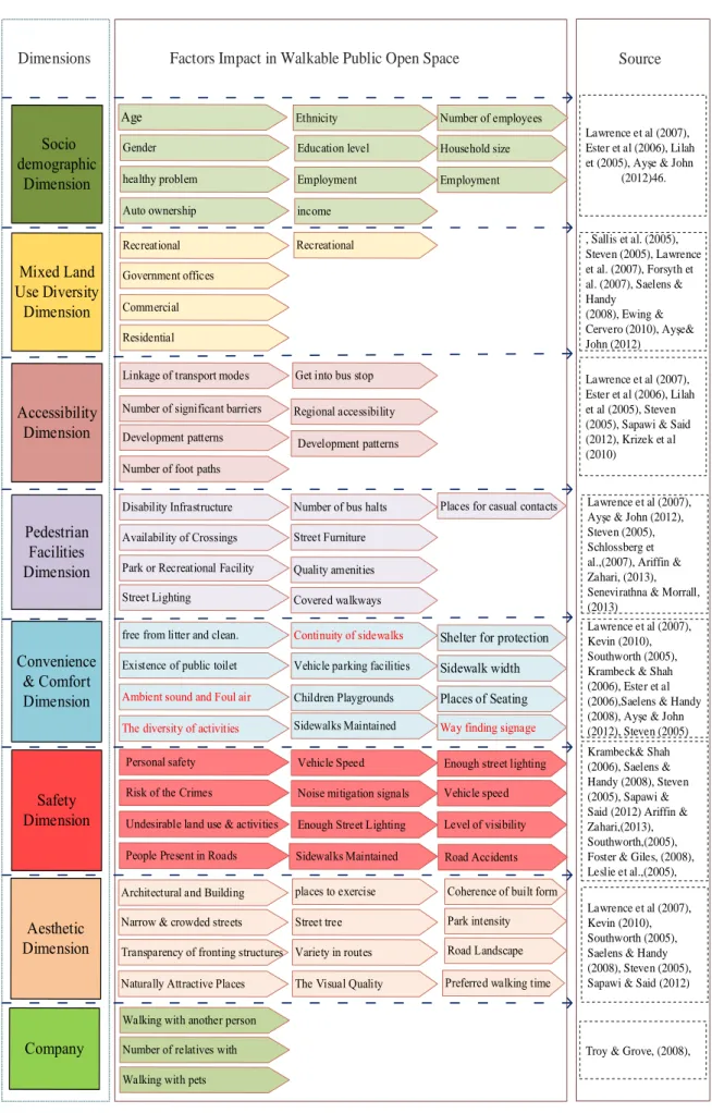
Figure 3-7 Dimensions and factors impact in walkable public open spaces... 71
Figure 4-1 Flowchart showing the research process ... 75
Figure 4-2 Key elements in the observation of public open spaces ... 88
Figure 5-1 Publications in the area ... 100
Figure 5-2 The Factors Upper 70%, Which Have Been Sent Back to the Experts ... 111
Figure 5-3 Delphi results on walkability factors impact in Libyan cities ... 125
Figure 6-1 Number of respondents in each case study area ... 127
Figure 6-2 Actual eigenvalue from PCA and criterion value from parallel analysis ... 148
Figure 6-3 Most selected success factors ... 154
Figure 6-4 Actual eigenvalue from PCA and criterion value from parallel analysis ... 157
Figure 7-1 Use of W-POS dimension accessibility ... 172
Figure 7-2 Use of W-POS dimension pedestrian facilities ... 172
Figure 7-3 Use of W-POS dimension land use ... 173
Figure 7-4 Use of W-POS dimension aesthetics ... 173
Figure 7-5 Use of W-POS dimension safety and security ... 174
Figure 7-6 Use of W-POS dimension convenience & comfort... 174
Figure 7-7 Actual eigenvalue from PCA and criterion value from parallel analysis ... 180
Figure 7-8 Evaluation of current POS design and management practice ... 184
Figure 7-9 Best equipped stakeholders to manage and design POS ... 185
Figure 8-1 Four public open spaces used as case study areas ... 192
Figure 8-2 OMS as low walkable open space with poor environment condition (LW/PC) ... 194
Figure 8-3 Public transportation in Tripoli ... 202
Figure 8-4 Roads around OMS ... 203
Figure 8-5 Pathway system in OMS ... 204
Figure 8-6 Attraction point barriers to pedestrian pathways ... 206
Figure 8-7 Land use around OMS ... 207
Figure 8-8 MSas high walkable open space with good environment condition ... 210
Figure 8-9 Junctions between (1) MS and Mizran Street; (2) MS and Old City; (3) MS and OMS in seafront site ... 218
Figure 8-10 Barriers facing users in MS ... 219
Figure 8-11 Attraction point barriers to pedestrian pathways ... 220
Figure 8-12 Land use around MS ... 222
Figure 8-13 Various features of MS... 224
Figure 8-14 AS as low walkable open space with good environment condition ... 226
Figure 8-15 Junctions (1-4) between AS and surrounding streets and use for car parking (photos a-c)... 233
Figure 8-16 Lack of pedestrian access ... 234
Figure 8-17 Pedestrian pathways ... 235
Figure 8-18 Land use around AS ... 236
Figure 8-19 Views of Masjid Gamal Abdel Nasser, Algeria Square, and Post Office ... 238
Figure 8-20 Lack of traffic lights and pedestrian crosswalk ... 239
Figure 8-21 Top: good condition of pedestrian pathways, Bottom: garbage piled up in streets around AS ... 240
Figure 8-22 RS as high walkable open space with poor environment condition ... 241
Figure 8-23 Use of RS and surrounding streets for car parking ... 247
Figure 8-24 Use of attraction points for car parking ... 248
Figure 8-25 Land use around RS ... 250
Figure 8-26 The Fish Market (Souq Al-Hut), Al-Rasheed Street ... 251
Figure 8-27 Pathways blocked to users by vehicles ... 252
Figure 8-28 Pedestrian pathway used for car parking and garbage ... 253
Figure 8-29 Number of users in the four case study areas in weekend time ... 254
Figure 8-30 Difference between four case study areas in POS visiting time... 254
Figure 8-31 Number the POS users by gender... 255
Figure 8-32 Number of vehicles around case study areas ... 256
Figure 8-33 Number of users in the four case study areas on weekdays ... 256
Figure 8-35 Number of users by gender ... 258
Figure 8-36 Number of vehicles around case study areas ... 258
Figure 9-1 Session 2 focus group discussion ... 263
Figure 9-2 Main barriers limiting walkability in POS ... 264
Figure 9-3 Success factors affecting walkability in Tripoli ... 272
Figure 10-1 Refined factors from Delphi method (n = 45) ... 281
Figure 10-2 Main barriers to walkability in Tripoli’s POS ... 283
Figure 10-3 Walkability evaluation model in Omar Al-Mokhtar ... 289
Figure 10-4 Walkability evaluation model in Martyrs’ Square ... 290
Figure 10-5 Walkability evaluation model in Algeria Square ... 291
Figure 10-6 Walkability evaluation model in Rasheed Street ... 292
Figure 10-7 An Assessment Framework For Walkability in Tripoli’s city centre Public Open Spaces ... 300
List of Tables
Table 1.1 Road traffic accidents in Libya (2005-2010) ... 5
Table 1.2 Prevalence of overweight and obesity in different countries ... 6
Table 1.3 Crime in Tripoli, Libya ... 7
Table 2.1 The street as a channel of movement ... 27
Table 3.1 City categorization based on physical characteristics ... 47
Table 4.1 Delphi method consensus rankings ... 78
Table 4.2 Level of confidence and associated z-values ... 83
Table 4.3 Sample sizes for different population at a 95 confidence level ... 84
Table 4.4 Cronbach’s alpha... 92
Table 5.1 Delphi panel participation ... 97
Table 5.2 Respondent profiles... 99
Table 5.3 Level of experts’ consensus ... 101
Table 5.4 Round one, socio-demographic factors ... 102
Table 5.5 Round one, mixed land use factors ... 103
Table 5.6 Round one, accessibility factors... 104
Table 5.7 Round one, company factors ... 105
Table 5.8 Round one, pedestrian facilities factors ... 106
Table 5.9 Round one, convenience & comfort factors... 107
Table 5.10 Round one, safety factors ... 108
Table 5.11 Round one, aesthetic factors ... 109
Table 5.12 Round one, case study selection ... 112
Table 5.13 Round two, socio-demographic factors ... 114
Table 5.14 Round two, mixed land use factors ... 115
Table 5.15 Round two, accessibility factors ... 116
Table 5.17 Round two, convenience & comfort factors ... 118
Table 5.18 Round two, safety factors... 120
Table 5.19 Round two, aesthetic factors ... 122
Table 5.20 Round two, final case study selection ... 124
Table 6.1 Maximum length of time spent in location ... 127
Table 6.2 Kruskal-Wallis test ... 128
Table 6.3 Gender and maximum length of time spent walking in location ... 130
Table 6.4 Kruskal-Wallis test between gender and time spent in walking ... 131
Table 6.5 Age, maximum length of time spent walking in location ... 132
Table 6.6 Kruskal-Wallis test for age and time spent in walking ... 133
Table 6.7 Education level, maximum length of time spent walking in location ... 134
Table 6.8 Kruskal-Wallis test between education and time spent in walking ... 135
Table 6.9 Case study areas and revisiting POS ... 136
Table 6.10 Kruskal-Wallis test between case study areas and revisiting POS ... 137
Table 6.11 Gender, case study areas and revisiting POS ... 138
Table 6.12 Kruskal-Wallis gender and revisiting POS ... 138
Table 6.13 Age, Case study areas and revisiting POS ... 140
Table 6.14 Kruskal-Wallis test between age and revisiting POS... 141
Table 6.15 Education level, case study areas and revisiting POS ... 142
Table 6.16 Kruskal-Wallis test between education level and revisiting POS ... 143
Table 6.17 Barriers affecting time spent in walking and revisiting POS ... 144
Table 6.18 Rotated component matrix for ‘barriers affect’ question ... 146
Table 6.19 Parallel analysis for ‘barriers to walk and revisiting POS’ correlates ... 147
Table 6.20 Barrier component’s properties ... 148
Table 6.21 Correlations between barrier factors and POS walking duration ... 150
Table 6.22 Correlations between barrier factors and revisiting POS ... 151
Table 6.24 Rotated component matrix for ‘success factors’ question ... 155
Table 6.25 Parallel analysis for ‘the success factors that affect in users to spend time for walk and revisiting POS’ correlates ... 156
Table 6.26 Success factors’ component properties ... 158
Table 6.27 Correlations between the success components and POS walking duration ... 160
Table 6.28 Correlations between success components and revisiting POS ... 160
Table 7.1 Respondents’ fields of experience ... 165
Table 7.2 Respondents’ years of experience ... 165
Table 7.3 Respondents’ workplaces ... 166
Table 7.4 Respondents’ academic qualifications ... 166
Table 7.5 Respondents’ academic qualifications ... 170
Table 7.6 Respondents’ opinions ... 175
Table 7.7 Use of professional experience ... 175
Table 7.8 Respondents’ level of satisfaction... 176
Table 7.9 Barriers affecting walkable public spaces in Tripoli ... 177
Table 7.10 Rotated component matrix for ‘barriers affecting walkable POS’ question .... 179
Table 7.11 Parallel analysis for ‘barriers affecting walkable POS from the relevant professionals’ perspectives correlates ... 180
Table 7.12 Barriers affecting walkable POS from the relevant professionals’ perception component properties ... 181
Table 7.13 Respondents’ level of satisfaction of designing and managing POS in Tripoli ... 183
Table 7.14 Success factors for Tripoli’s POS to be walkable ... 187
Table 8.1 The observation in Omar Al-Mokhtar Street, weekend ... 196
Table 8.2 Four Seasons observation in Omar Al-Mokhtar Street, weekend ... 197
Table 8.3 Observation in Omar Al-Mokhtar Street, weekday ... 199
Table 8.5 Observation in Martyrs’ Square, weekend ... 212
Table 8.6 Four Seasons Observation in Martyrs’ Square, weekend ... 213
Table 8.7 Observation in Martyrs’ Square, weekday ... 215
Table 8.8 Observation in Martyrs’ Square, weekday ... 216
Table 8.9 Observation in Algeria Square, weekend ... 227
Table 8.10 Four Seasons of Observation in Algeria Square, weekend ... 228
Table 8.11 Observation in Algeria Square, weekday ... 230
Table 8.12 Four Seasons of Observation in Algeria Square, weekday ... 231
Table 8.13 Observation in Al-Rasheed Street, weekend ... 242
Table 8.14 Four Observation Season in Al-Rasheed Street, weekend ... 243
Table 8.15 Observation in Al-Rasheed Street, weekday ... 244
Table 8.16 Four Observation Sseasons in Al-Rasheed Street, weekday... 245
Table 9.1 Participants’ expertise ... 262
List of Abbreviations
WHO World Health Organization,
POS Public open spaces
W-POS Walkable public open spaces
FGD Focus group discussion
PPS World Organization for Projects of Public Spaces
MENA Middle East and North Africa
KW Kruskal-Wallis test
PCA Principal component analysis
LW/PC Low walkable open space with poor environment condition HW/GC High walkable open space with good environment condition LW/GC Low walkable open space with good environment condition HW/PC High walkable open space with poor environment condition
NEWS Neighbourhood Environment Walkability Scale
NQLS Neighbourhood Quality of Life Survey
OMS Omar Al-Mokhtar Street
MS Martyrs’ Square
AS Algeria Square
RS Al-Rasheed Street
List of Publications
1- Khairi Mohamed A. Abdulla, Mohamed Gamal Abdelmonem, Gehan Selim, 2016.
Understanding Walkability in the Libyan Urban Space: Policies, Perceptions and
Smart Design for Sustainable Tripoli. International Journal of Civil, Environmental,
Structural, Construction and Architectural Engineering, 10 (12), 1602-1610.
2- Khairi M. Al-bashir Abdulla, Mohamed Gamal Abdelmonem, Gehan Selim, 2017.
Walkability in Historic Urban Spaces: Testing the Safety and Security in Martyrs'
Chapter 1
Introduction
Cities around the world are facing problems due to traffic congestion, air pollution, and
traffic accidents because of the fast increase in the ownership and usage of vehicles, and it
has become a critical cause of social, safety, and environmental problems in urban areas
(Groenewegen et al., 2006). For example, every year approximately 1.3 million pedestrians,
cyclists, and motorcyclists worldwide are killed in road traffic accidents, and more than 90%
of such deaths occur in developing countries (WHO, 2009). Moreover, traveling in vehicles
rather than physical activity (walking) is a major risk factor for overweight and obesity,
diabetes, heart disease, and some cancers (United States Department of Health & Human
Services, 2002).
Conversely, many of the most serious health problems of the 21st century are due to
sedentary lifestyles, and cities that prioritise walking offer increased recreational
opportunities, benefiting the economies of such cities (e.g. the retail industry) and their
institutions, associated with various health, social, safety, environmental, and economic
benefits for individuals compared to life in vehicle-dependent cities (Leinberger and
Alfonzo, 2012; Wen and Xu, 2013; Talen and Koschinsky, 2014). Important studies have
identified the built environment as an essential factor for integrating physical activity into
daily life and thus improving public health (Frank et al., 2003; Sallis et al., 2011; Cerin et
al., 2013), and public open spaces (POS) in city centres are important built environment
elements, with the potential to increase the intention of walk for the city residents, workers,
visitors, and other users ( Geh, 2010; Littke, 2015; Pradinie et al., 2015; Chen, 2016).
Urban design, urban planning and transportation studies have inspected walkability in POS
as a root solution to many complex problems in modern societies (Gehl, 1989; Hillier, 1996;
factors that underpin the creation of walkable POS to attract a wide variety of people, which
has been given keen attention at the policy level due to the generally grim implications of
the digital economy and internet of things for traditional cities and urban spaces, with
governments and political pressure seeking remedies for the decline of traditional high
streets, and seeking new roles for urban institutions whose traditional services are
increasingly supplanted by modern technological solutions, such as e-government (Gehl,
1987, 2010; Ewing, 2005, 2010; Sallis, 2005; Southworth, 2006, 2009; Lawrence, 2007;
Saelens, 2009).
In additions, previous studies highlighted that POS in developed countries have always
evolved following changing public needs and demands (Conway, 2006). More recently, the
looming public health crisis of sedentary lifestyles and obesity-related illness has begun to
concern governments and increasing attention has been given to the lack of POS in cities in
most developing countries, exacerbating problems including heart disease and some cancers
(WHO, 2016). Unfortunately, in the cities of developing countries like Tripoli, the POS are
mostly used as refuse dumps, for informal trading activities, and for car parking (Abdull et
al., 2016). This research looks at the walkable POS (W-POS) and the ways in which
dimensions of POS affects walkability in general in Libyan cities, and especially in Tripoli,
Libya. It examines the concept of walkability in outdoor POS within the urban context of
Tripoli and different zones in the city.
This thesis answers how and why POS are used as walkable spaces in Tripoli. It investigates
users and their motivations and ways and times of using POS in groups and individuals, for
males and females. The analysis of the findings contributes to the discussion of value and
the perceptions of the quality of the POS in Tripoli by presenting the perspectives of the
general users and experts, and the knowledge experience of the researcher, in terms of the
1.1
Problem statement
Cities worldwide have been rapidly expanding for decades (Grimm et al., 2008). Tripoli, the
capital city of Libya, is one of the fastest growing cities in the Middle East and North Africa
(MENA) region, with a population of about 1,600,000 people in 2010, comprising 27 per
cent of the national population (Ali et al., 2011). Over time, city centre properties for
redevelopment have become rare, and the number of vehicles continues to increase yearly,
reaching over 1.8 million a decade ago (Al-Fenadi, 2008). Likewise; Ismail and Elmloshi
(2011.p 3) illustrated that ‘‘approximately 66% of Tripoli’s residents prefer to use their cars
and only 34% resort to depending on public transports namely taxi, coaches and microbuses
for their transportation activities in the city centre area’’. According to 2008 data, the daily
average number of vehicles using Tripoli’s roads is 898,707, at the peak period from 7 am
to 7 pm (Ismail and Elmloshi, 2011).
In Libya, rapid net population growth and rural-urban migration were intensified by the
discovery of oil and brought demographic polarisation with high concentration in large
cities, particularly Tripoli and Benghazi. As noted by UN-Habitat (2013), Libya has the
highest urban concentration in North Africa, increasing from 77.89% of the population living
in cities in 2008 to 88.9% according to the 2012 census, projected to continue rising until
2030. On the other hand, this increase in the population of Libyan cities in general and
Tripoli in particular (the national capital, and the case study of concern to this study) was
not matched by a commensurate evolution in public planning.
In Tripoli, the weaknesses of urban form, physical environment and transportation network,
roads and pavement exacerbates the auto-oriented system, depresses walkability, and
encourage private transportation. In addition, most of the comprehensive plans prepared at
different times and by different planning companies and consultants have not been effective,
failing to reduce traffic congestion and increasing automobile dependence in Tripoli city
Appleyard (1981) observed that the increasing use of vehicles since the mid-20th century has
reduced social life outdoors in urban environments. He analysed three different streets,
showing that increasing traffic volume made many residents leave public spaces and focus
their lives in quieter suburban or commuter areas, away from POS. In general, Tripoli city
centre was already built up and congested before the mass use of cars, according to the
traditional medina model of urban design in the region (i.e. with a compact citadel with
central POS and surrounding residential quarters enclosed within a city wall). Nowadays,
driving has become the primary mode of travel in Libya, replacing more active forms of
transportation like walking, biking, and public transit. In addition, from 1995 to 2010 the
total registered vehicles recorded increased from 109,750 to 2,424,385. As shown in Figure
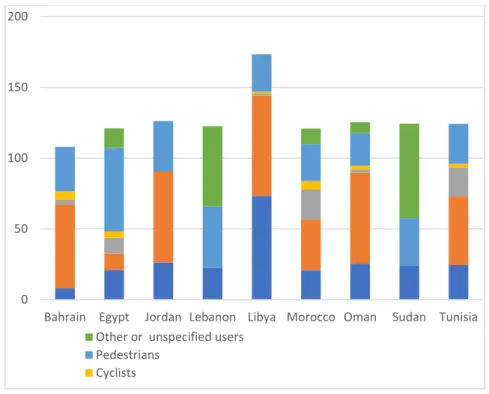
1-1, Libya has a particularly high number of road-related fatalities, with the majority of
deaths being people in vehicles (WHO, 2015).
As a result of the increase in vehicle users in the context of poor urban planning and traffic
management, traffic accidents have also increased. Table 1.1 shows the gradual rise of the
deaths number in Libya from 2005 to 2010 because of car accidents. Five people die every
day according to the Secretariat of the Libyan Justice, and the deaths are expected to reach
25 cases/day in the coming years (Traffic Office and Licensing of Tripoli 2010; Yahia and
Ismail, 2014), which is why it is important to create walkable city centres in Libya. However,
the current management paradigm reiterates the legacy system, rooted in trying to adapt the
city to the car, and a radical reorientation of solutions brought by public authorities is
necessary (Matugh and Lakhder, 2010). This study contributes to this area by providing
empirical evidence, supported by prevailing theoretical knowledge, to support the
Figure 1-1 Proportion of reported road traffic deaths by road user type in 10 MENA countries, 2013
Source: WHO (2015)
Table 1.1 Road traffic accidents in Libya (2005-2010)
Year Accidents Car Deaths Injured
2005 11898 15276 1800 5380 2006 11982 16890 1866 5663 2007 13165 17859 2138 5950 2008 13352 18662 2332 6424 2009 13664 20668 2301 6791 2010 Jan-Apr 5277 7541 806 2290 Source: Author
Aside from the direct negative safety impacts of automobiles and poor planning, sedentary
behaviours associated with living in more car-dependent cities have a range of ill-health
outcomes, including weighing on average 4.2 kg heavier (Chiu et al., 2014). Obesity and
low levels of physical activity are primary health problems in both developed and developing
countries, including Libya. Elmehdawi and Albarsha (2012) explained that ‘Obesity is a
global epidemic resulting in major morbidity and premature death. About 64% of Libyan 0
50 100 150 200
Bahrain Egypt Jordan Lebanon Libya Morocco Oman Sudan Tunisia Other or unspecified users
Pedestrians Cyclists
adults are either overweight or obese, obesity progressively increases with age, and two
times more common among Libyan women than men’. Rao et al. (1984) found that in Tripoli
was 12.6% (with a sharp gender difference: 42.5% in women and 7.7% in men). As Table
1.2 shows, by 2009 the prevalence of obesity had increased by 2.42 times, with a slight
reduction among females and a massive increase among males.
Table 1.2 Prevalence of overweight and obesity in different countries
Country Overweight Obesity
Male (%) Female (%) All (%) Male (%) Female (%) All (%) Libya (2009) 36.1 29.7 33 21.4 40.1 30.5 USA (1999-2008) 40.1 28.6 34.2 32.2 35.5 33.8 KSA (1995-2002) 42.4 31.8 36.9 26.4 44 35.6 Tunisia (1997) 23.3 28.2 27.4 6.7 22.7 14.4 Turkey (2001-2002) 46.5 28.6 36.8 16.5 29.4 23.5
Source: Ministry of Health-Libya (2011)
Users frequently report their fear of being subject to a crime when they are in dark, empty,
and quiet streets (Vrij and Winkel, 1991). Over 50 years ago, Jacobs (1961) wrote about this
relationship and established the concept of ‘eyes on the street’. One of the main elements of
a liveable urban centre is that people feel safe and secure in POS; it is full of people, despite
them being complete strangers in most cases. Nowadays Libya has high crime rate, as
NUMBEO (2017) shown in their reports based on visitor perceptions over the previous three
years; the scores for various aspects of life in Tripoli are shown in Table 1.3. Safety walking
alone during daylight in Tripoli Libya is 60.33%, which is high, while safety walking alone
at night is 35.87%, which is low. Finding the reasons for the high perceived rate of crime in
Table 1.3 Crime in Tripoli, Libya
Crime type Crime rate
in Tripoli
Safety rates in Tripoli
Categories of Crime
Level of crime 63.33% 36.67% High
Crime increasing in the past 3 years 68.48% 31.52% High
Worries being mugged or robbed 61.96% 38.04% High
Worries attacked 49.46% 50.54% Moderate
Worries being insulted 43.89% 56.11% Moderate
Worries being subject to a physical attack because of your skin colour, ethnic origin or religion
42.78% 42.78% Moderate
Problem property crimes such as vandalism and theft
53.89% 46.11% Moderate
Problem violent crimes such as assault and armed robbery
61.96% 38.04% High
Source: NUMBEO (2017)
1.2
Lack of walkability assessment tools for Libyan city centres
Many tools have been developed with the aim of assessing the walkability environment from users’ point of view, in order to be able to address their needs, and to provide answers to the question of how walkable a place is. City centres include public open spaces such as squares,
parks, streets, and pavements, all of which have an important role in encouraging people to
walk in city centres, and they are the central attractions of cities. Consequently, they can
make some cities more inviting and more walkable than others (Ewing and Clemente, 2013).
Most walkability measurements have focused on neighbourhood living and assumed
walking motivations that are typical for urban cities, with an emphasis on destinations (e.g.
transit stops and parks), as well as detailed assessments of traffic features such as
cross-walks and pavement width (Saelens et al., 2003; Brownson et al., 2009; Zenk et al., 2009;
Kegler et al., 2015). Lo (2009) argued that many researchers have evaluated the relations
between urban environments and pedestrian behaviour, and all have different explanations
different disciplines (e.g. transportation planning, urban planning, urban management, and
urban design) include the following:
• Walkability Index (WI), the most popular measure in the literature (Saelens et al.,
2003).
• Walk Opportunity Index (WOI) (Kuzmyak et al., 2006).
• Neighborhood Destination Accessibility Index (NDAI) (Witten et al., 2011).
• Walkability Scale (WS) (Freeman et al., 2012).
• Pedshed (Ps) (Porta and Renne, 2005).
• Extended Walkability Index (EWI) (Buck et al., 2014).
• Moveability Index (MI) (Buck et al., 2014).
• Pedestrian Index of the Environment (PIE) (Singleton et al., 2014).
• Walk Score (WS), a commercial solution (Koschinsky et al., 2017).
• Neighbourhood Environment Walkability Scale (NEWS), International Physical
Activity and the Environment Network (IPEN), Neighbourhood Quality of Life
Survey (NQLS), and International Physical Activity Questionnaire (IPAQ) (Craig et
al., 2003; Saelens et al., 2003a; Cerin et al., 2007).
Clearly there are many available tools, but few researches have investigated walkable places
in developing countries in Arabic language /English language, or whether these tools are
suitable to explore walkability in non-Western and non-developed countries, where people
may have different walking needs and expectations relative to existing urban facilities.
Consequently, this thesis contributes to this field by applying a walkability study to Tripoli,
Libya. Developing assessment tools for public open spaces and testing them in developing
countries helps transportation planners, urban planners, decision makers, and urban
1.3
Safety and security issues in Tripoli
Unfortunately, issues of civil war still exist around the Libyan cities since 2011. Appropriate
frameworks were carefully considered to avoid any ethical issues while conducting the
research, and the fighting can break out anywhere without warning. Before 2011 Tripoli was
a safe city, as the core of the government resided there, and the issues of safety and security.
While nowadays, everybody is worrying about their safety and security. The security
situation has deteriorated in Libya, and the government is no longer in control. So, the
researcher needed to assess when he could safely visit Tripoli and ensure his personal safety.
Also, the factor of safety and security become very important for the public open spaces’
users.
1.4
Research question
This research thesis addresses the following research question:
• What are the barriers to the implementation of walkability in Tripoli city centre? And
what are the main factors influencing users of Tripoli city centre to incorporate
walking as part of daily activity in public open spaces?
1.5
Research aim and objectives
The research aim is to provide a comprehensive analysis of barriers and factors that influence effective practices, compatibility, and application of the notion of ‘walkability’ for urban and civic public spaces in Libyan cities, and to develop a framework for planning strategies
for walkability as a creative tool to inform the efficiency, performances, and user experience
of a walkable (i.e. walker-friendly) city.
Objectives:
1. To investigate the notion of walkable public open spaces, and best practices of
2. To develop an evidence-based methodology and measurement tools to evaluate the
suitability of those practices for Libyan cities.
3. To explore the demographics, needs, and practices of public users in Tripoli’s POS
in terms of walkable spaces in a metropolitan centre in a post-conflict situation.
4. To identify users’ experiences the time they spend, and the pedestrian movement
patterns in the four case study areas in Tripoli POS.
5. To identify the barriers, needs, and success factors affecting people walking in
Tripoli POS from the perspectives of users and relevant professionals.
6. To evaluate walkability in Tripoli city centre in terms of planning, producing,
managing, and maintaining POS, as well as the factors of walkability, according to
the opinions of professionals and experts.
7. To develop and validate a framework for planning strategies for walkability as a
creative tool to inform the efficiency, performances, and user experience of a
walkable urban environment.
1.6
Research methodology
Overview
To answer the research question in this study, the study developed a working definition of
walkability through a literature survey and documentary analysis, which were used to
produce a critical overview of walkable space in their theoretical context. The review
determines types of urban spaces, its definition and approach, alongside the methods for data
collection. This thesis research method uses more than one data collection technique to
address different dimensions of the topic. This allows researchers to capture a more
complete, holistic, and contextual portrayal of and reveal the varied dimensions of a given
phenomenon and provides a better understanding of a research problem than using single
approaches (Creswell and Clark, 2007). Mixed methods case study comprising documentary
two comprising questionnaire surveys, fieldwork and observation, and focus group
discussions.
Phase one: Delphi method
This phase explores the consistency and the validity of the factors of walkability in POS
identified from the literature review their revenant to the streets and public squares on Libyan
cities in general and Tripoli in particular by matching theoretical insights with empirical data
from the studied sites (Sallis et al., 2005; Steven, 2005; Southworth, 2005; Ester et al., 2006;
Forsyth et al., 2007; Lawrence et al., 2007; Saelens & Handy, 2008; Ewing & Cervero, 2010; Ayşe and John, 2012; Sapawi and Said, 2012). Participants were selected by a number of strategies. Also, the online survey website Survey-Monkey was used to host the survey.
Phase two
1.6.3.1 Questionnaire surveys
Thisphase matched the empirical findings with the objectives of this research, using mixed
quantitative (questionnaires for users and professionals) and qualitative (observation and
focus group discussion) approaches for data collection. Questionnaire surveys furnished data
for analysis from questionnaire surveys carried out between November 2016 and February
2018 concerning aspects of walkability in Tripoli.
1.6.3.2 Fieldwork and observation
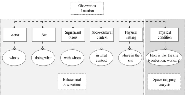
The second tool in phase two used in data collection during the fieldwork was observation.
This tool was chosen because the researcher had to learn about the phenomenon in its
context, in the field. It included the observation of the physical environment, and more
1.6.3.3 Focus group discussions
The third tool in phase two which have been used in data collection during the fieldwork
was focus group discussion (FGD). The researcher adopted FGD for the following reasons:
• To validate the result from the questionnaire survey, it was necessary to collect data
that was based on human judgment.
• The outcome of the validation process from the focus group was considered as
reliable, and the reason behind that was that the people engaged in the focus group
was a group of experts who had several years of experience in the area of POS design
and management, and to formulate a more in-depth analysis by involving a number
of government officials and users.
1.7
Structure of the thesis
This thesis consists of nine chapters followed this introduction, which are outlined as
follows.
Chapter 2 (Public Open Spaces) focuses on the existing knowledge and information using various literature sources. This chapter deals with the concept, importance and function of
POS in cities in terms of configuration and visual and aesthetic aspects. It identifies types of
POS in general and introduces those in Libya relative to theory based on the concept of POS,
including the urban environment and its relationship to the walkability and pedestrian
movement.
Chapter 3 (Walkability) focuses on existing knowledge and information using various literature sources to provide the precise definition of walkability, as well as determining
walkable POS measurement tools and walkable POS dimensions and elements.
Chapter 4 (Research Methodology) explains the research methodology in detail, providing a clear picture of the thesis design, and the overall approaches and methods used in exploring
Chapter 5 (Phase 1: Determination of walkable dimensions and case study areas selection) presents phase one of this thesis (Delphi method), which determines the dimensions and factors that may affect in Libya’s POS, and the case study areas selected in
this chapter are explained.
Chapter 6 (Analysis and Results of The Questionnaire for the Users) presents the quantitative results of phase two, including the data obtained from the questionnaire surveys
for users. This chapter details and summarises the findings using SPSS for data analysis.
Chapter 7 (Analysis and Results of The Questionnaire for the relevant professionals)
presents the quantitative results of phase two, including the data obtained from the
questionnaire surveys for relevant professionals. This chapter details and summarises the
findings using SPSS for data analysis
Chapter 8 (Assessing walkability in Tripoli’s Public Open Spaces: Observation Method) presents the qualitative results of phase two, comprising the data obtained from the observation survey in the four case study areas. This chapter details and summarises the
findings using maps, pictures, and observation sheets
Chapter 9 (Focus Group Discussion) presents further qualitative results from phase two from FGDs in the four case study areas. The data was analysed manually.
Chapter 10 (Findings and Discussion) presents the discussion of the research findings based on the data in the context of previous literature. This chapter links the finding of the
previous chapters together.
Chapter 11 (Conclusions and Recommendations) summarises the most important contributions of the research and proposes further recommendations and research directions.
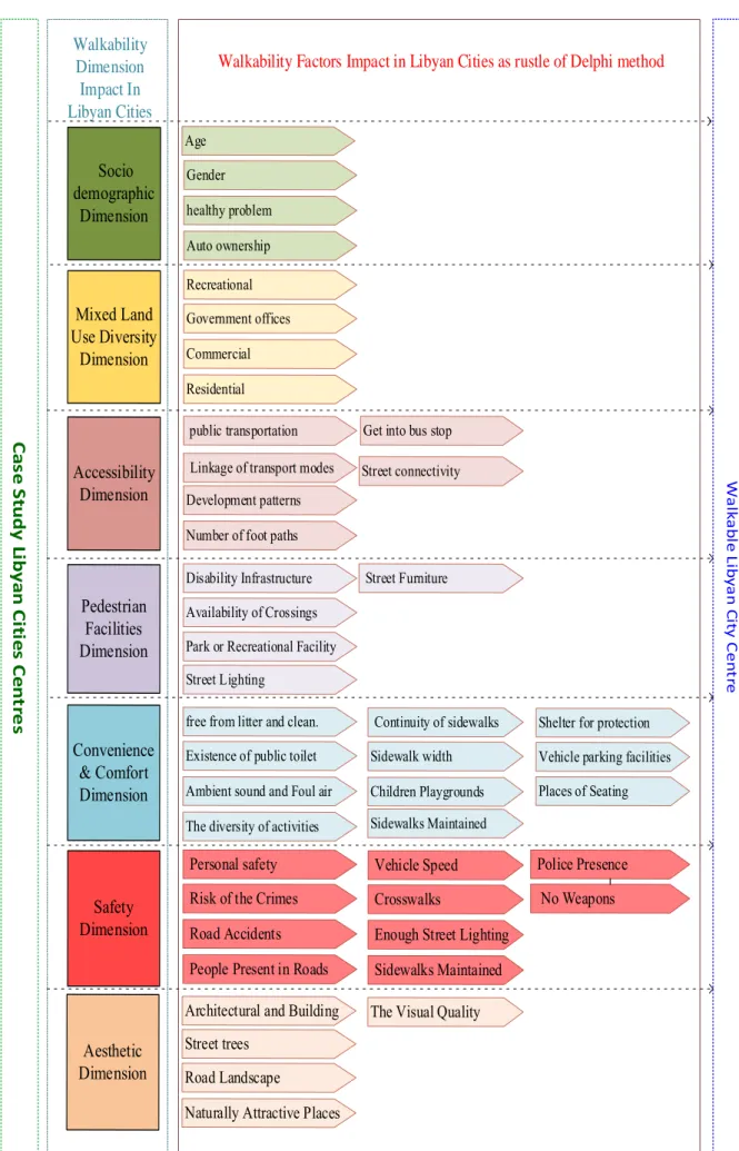
Round 1: Walkability Dimensions
Socio
Demographic Accessibility Aesthetic
Mixed land use diversity Company Dimension Pedestrian facilities Safety
Selection of Cases Study
H.W/G.C 1- Martyrs Square 2- Algeria Square 3- 24th December Street 4- Omar al-Mukhtar Street H.W/P.C 1- Al-Rasheed Street 2- Algeria Square 3- Al-Aistiqlal Street L.W/G.C 1- Omar al-Mukhtar Street 2- Algeria Square 3- Al-Aistiqlal Street 4- Martyrs' Square L.W/P.C 1- Algeria Square 2- Al-Suehaliy Square 3- Mazran Street 4- Al-Rasheed Street Socio
Demographic Accessibility Aesthetic
Mixed land use diversity
Pedestrian
facilities Safety
Selection of Cases Study
H.W/G.C 1- Mar tyrs Square H.W/P.C 1- Al-Rasheed Street L.W/G.C 1- Omar al-Mukhtar Street L.W/P.C 1- Algeria Square
Round 2: Walkability Dimensions
Phase Two: Mixed Method Phase one: Delphi Method
Research Methodology
Quantitative Research Qualitative Method
Questionnaire for Users Questionnaire for The
professional Observation Focus Group Discussion Pilot Study Pilot Study Pilot Study
Desiccation And Framework Developing
Recommendation and Conclusion Literature Review
Determine the Dimensions and Factors of Walkability Determine the Walkability
Measurement Method Definition of Public Open
Spaces Analysis By SPSS Analysis By SPSS Manual Description Analysis Manual Description Analysis 07/03/15 15/03/15 22/07/16 20/11/16 15/05/18 20/08/18 20/04/19 Task 1 Determine the important dimensions walkability which worked with Libyan public spaces, Task 2 :-Selected four initial Case Study Area Task 1 :- Determine the important walkability dimensions which worked with Libyan public spaces, Task 2 :- Selected four final Case Study Area
L: Law, H: High, W: Walkable, G:Good, P: Poor, and C: Environment Condition, Timetable
21/11/16 20/12/16
Figure 1-2 Flowchart showing the research process Source: Author
Chapter 2
Overview of Public Open Spaces
This chapter deals with the concept, importance and function of POS in cities in terms of
configuration and visual and aesthetic aspects. It identifies types of POS in general and
introduces those in Libya relative to theory based on the concept of POS, including the urban
environment and its relationship to the walkability and pedestrian movement. This chapter
also identifies the dimensions and the needs of POS.
2.1
Definition of public open space
The concept of POS has always been central to urban contexts throughout history; human
settlement is fundamentally based on POS. Different scholars have seen POS from various
aspects, Lynch (1960) defined open space as one of the substantial lands uses that propose
to provide functions as ‘recreation, community health, contact with nature, social or
conservation’ within a part of the city. Today, more than half of the population around the
world lives in cities. Cities have always varied in size, and have been abandoned in many
cases, but generally they were of stable proportion in pre-industrial, agrarian societies.
However, since the 19th century cities have become more crowded, and urban open spaces
within them have declined (Chen, 2016). In order to conceptualise POS, it is necessary from
the outset to define them.
Pradinie et al. (2015) defined the public open space as a ‘place to be public’, and a ‘place to
be free’; aside from such general understandings, there are certain institutionalised more
associated with de facto POS (e.g. public parks or market places governed by specific civic
and national regulations). POS are spaces to which means that all people have the right to
use at any time. POS can be parks, playgrounds, trails, waterfront and streets (Floyd et al.,
be managed as the places offering an equal right of access to all groups of users, ranging
from teenagers to old people with physical difficulties.
Technically, POS concerns human experience and builds on physical and social aspects of
the city (Calderon and Chelleri, 2013; Kratochvíl, 2013; Askari et al., 2015). Within the
disciplines of urban planning and urban design, there is more attention in studying the
relationship between political processes, social and economic and the way POS are provided
and managed (Inam, 2002; Thompson, 2002; Schmidt and Nemeth, 2010). Much research
has been done by sociologists, planners, architects, geographers, and urbanists. about POS,
and one point of consensus is that the ultimate goal of POS is to improve the quality of the
outdoor public space and attract more people to use the POS (Zacharias et al., 2001, 2004).
Tang and Wong (2008) argue that POS is often viewed as a fundament part of ‘public space’
which may refer to diverse types of features and physical forms. Previous research has
documented the importance of POS for providing opportunities for social interaction,
avoiding a sense of loneliness and promoting social life amongst the elderly (Kweon et al.,
1998; Yung et al., 2016).
In recent years, research into public open space has become increasingly popular due to
fundamental changes in public life and digital technologies, which have fundamentally
changed traditional urban spaces. Many scholars and authors have thus tried to determine
the specifications of POS from various perspectives, and to identify the factors of successful
POS. A pioneering study by Lynch (1960) selected five factors that must be met in POS to
ensure its success: vitality, sense, fit, access, and control. Jacobs and Appleyard (1987)
suggested that seven objectives are necessary: identity, liveability & and control, access to
opportunities, authenticity and meaning, community and public life, urban self-reliance, and
an environment for all (i.e. inclusivity, and disabled access in particular).
Jan Gehl (2004; 2010; 2011) highlights several design aspects which would encourage using
essential parameters. He describes that the time that people spend in places in the city
depends on feeling comfortable both psychologically and physically, and if the level of
comfort is low, the time people spend in POS will be short. While enjoyment dealing with
how users can be pleased the positive aspects of the weather, enjoy the views and vistas, the
artistic quality of the design of the POS and its finer details, and also the pleasure of the
experience of the landscape (trees, plants and water). Finally, Protection covers on a wide
range of protective measures that the place provides to minimise unpleasant experiences,
including safety and security, shelter and protection from traffic.
In the same way, the World Organization for Projects of Public Spaces (PPS) tried to develop
specifications of successful POS and annexation under four main specifications: uses and
activities, comfort and image, access and links, and sociability. Three main factors are
related to the effective use of POS, namely users’ needs, the quality of the physical features,
and the spatial structure of the space (Abbasi et al., 2015). Considering users’ needs is the
foundation for any well-designed POS, requiring a design that attracts people, facilitates
their activities, and encourages them to spend more time in the space while undertaking these
activities (Francis, 2003). At the intersection of the academic and policy literature, scholars
keenly debate the best ways to shape POS and to understand the ways in which they are
perceived and used. Fundamentally (with regard to the policy level), the formation and
management of POS depends on traffic, topography, aesthetic design, and uses (Carmona et
al., 2003).
2.2
Characteristics of public open space
Gehl (1980) explained the quality of POS in terms of their types of user activities: social,
optional, and necessary activities (more discussion has been done in section 3.7.2). However,
much previous research has been descriptive on the success and failure of POS shown in
three essential qualities: use, activity, and circulation (Project for Public Space, 2005).
the quality of the physical features, and the spatial structure of the space (Abbasi et al., 2016).
Consideration of user’s needs is the backbone for any good design of POS. Francis (2003)
noted that designs that attract people, facilitate their activities, and encourage them to spend
more time when undertaking these activities are optimal, and Kallus (2001) similarly argues
that quality relates to usability, with some standards depending on people’s needs and
perception. If POS fail to meet user needs, regardless of their other qualities (e.g. purely
aesthetic or environmental), they fail to be successful as POS (Carr et al., 1992).
2.3
Qualities of a successful public open space
Public open space usually has functional and physical conditions, which favourably or
unfavourably influence social interaction, user comfort and security, which attract users. The
physical and functional qualities of POS are related to activities, accessibility conditions,
physical amenities, location, and the surrounding land uses (Montero-Avila, 2001). As
previously stated, sociability, uses, and activities, access, linkage, and comfort and image
are the general parameters of successful POS (PPS, 2001). These attributes influence the
enjoyment of POS and the social life that occurs in them.
Social use of public open space
Mean and Tims (2005.p 38) wrote that ‘‘different people have different stocks of knowledge;
time and money, which together help shape their ability to access different spaces and places’’. Numerous scholars have aimed in their publications to discover the qualities of places that make a successful POS. POS encourages people in social interaction, gathering
and meeting, and public life is a crucial social binder which enhances social contact and
provides opportunities for entertainment and relaxation (Carr et al., 1992). An empirical
study of public open space, the Street has Life Project, used time-lapse cameras to record
daily patterns in plazas (Whyte, 1980). It was found that high numbers of people in groups
are an indicator of best uses in plazas and an index of selectivity, as users decide to go there
groups (i.e. 55% were individuals), and the ‘best-used plazas are sociable places. A high number of groups is a sign of excellent use of urban space (Madden & Schwartz, 2000).
In Tripoli, public open spaces are used in several daily social activities, which determine the
functional activity, such as human interactions, all kinds of movement, attractions in the
POS and details of components and the character of the open space (Al-muntasir, 2010). An
example of changing use of POS is given by Tripoli’s Martyrs’ Square. This was originally
erected during Italian colonisation and was characterized by a social and political function
of proclaiming the dominance of the Italian colonial authorities by being used for military
parades, while Algeria Square was designed for cultural use. The Italians enshrined a
monumental cathedral in Algeria Square to iterate the dominance of the colonial government
and the Italian colonists, which was subsequently appropriated by the Libyan people after
independence, and the conversion of the cathedral into a major mosque, as shown in Figure
2-1 and Figure 2-2. Gazelle Square represents a different use, being designed to tie the city
axes and open spaces within the urban fabric of the centre of the city of Tripoli (Al-muntasir,
Figure 2-1 The former Tripoli Cathedral, and Algeria/Elgazayer Square (1960s) Source: Wikipedia (2016)
Figure 2-2 Tripoli Cathedral (now a mosque) at present Source: Al-muntasir (2010)
Public open space for everyone
POS is one meaning of the urban environment that is of great importance in daily activities
for city’s users who live in their local urban neighbourhood. It is embedded in social,
physical, cultural, settings and perceptual contexts (Carmona et al., 2003). Likewise,
planners and designers must ensure that POS provides justice by designing for different
groups of users (Marshall, 2008), Likewise, planners and designers must ensure that POS
pushchairs, the disabled, family with children, and teenagers (Marshall, 2008). Also, POS
should include personal space for everybody; personal space is the distance kept between
two individuals to ensure they feel comfortable (Aljabri, 2014). On the other hand, the degree
of intimacy in a relationship enables such distances to be smaller between family and friends,
and further apart between strangers (Diversity Council, 2008).
Whyte (1980) found that users of mid-Manhattan plazas were on average 60% male and
40% female. Franck and Paxson (1989) highlighted that the features and physical design
aspects (amenities that support necessary activities such as shopping, and such as high
degree of visual access) may encourage female’s use of POS. Above all, successful POS
should take into consideration that the family-friendly space should have facilities for the
children, the elderly, men, and women.
User needs in public open space
Francis (2003) defined user needs as the amenities and experiences that the public demands
when enjoying POS, and user conflicts in POS can develop when user requests are not met,
or when there is a conflict between different user groups. POS is ultimately assessed by
people (i.e. users) according to whether they meet their needs; this is called place
dependence, which leads people to make comparisons and evaluate alternatives accordingly,
but which not necessarily about national correlations of place (Stokols and Schumaker,
1981). Carr (1992) added six user needs in POS, including comfort, relaxation, passive
engagement (enjoying the scene in POS without participating actively), active engagement
(with physical participation), and discovery.
2.4
Typologies of public open space
There are various ways to classify POS, such as size, how people use them, intended
function, and location. (Byrne and Sipe, 2010). The grouping of POS into types has been
resulted in either a typology or a hierarchy of urban open spaces (Woolley, 2003), however,
some spaces are formed informally, due to pressures such as lack of defined POS, urban
development, and social interactions.
According to Carr et al. (1992), OPS is one of the important characters of urban structure,
covering non-built (open), limited by blocks (closed). Moreover, modern views suggest the
need to add other elements of the OPS, such as space above public and private buildings,
which creates the visual identity and aesthetic character of cities. Moreover, the types of
POS are defined according to their levels of use, their levels of intervention, and their spatial
locations, (i.e. from the most undisturbed to the most highly developed), for example public
spaces such as squares, streets, and other areas provide high levels of social and cultural
functions (Maruani and Amit-Cohen, 2007). Other authors such as Lynch (1981) established
a typology for POS that identified regional squares, parks, plazas, adventure playgrounds,
playing fields, wastelands and playgrounds.
Tripoli has a unique POS that has developed over time, in response to popular needs and
regimes, producing various public parks, streets, and squares. However, some spaces, such
as the footpaths of main streets in Tripoli city centre, have developed recently into popular
public open space. Its typologies can be placed into categories and subcategories, as shown
in Figure 2-3, with three major POS typologies: green, civic, and leftover spaces. The latter
could be expanded to include loose fit spaces or found spaces, based on different types of
urban open spaces in the city and Libya. This accompanying classification, and
categorization is very useful, since it facilitates the identification of criteria for intervention
Public Open Spaces
Left over Spaces Civic Spaces Green Spaces • Park • Plazas • Gardens • Playground • Treed Streets • Outdoor sport • Roundabout • Medians • Squares • Markets • Pedestrian streets • Boulevards
• Other hard surfaced pedestrian area
• Reclaimed space
left overs with potential
• Corners
• Sidewalks
• Frontage or between
buildings
Figure 2-3 Types of urban open space Source: Francis (2003)
2.5
Streets as public open spaces in Tripoli
The word ‘street’ is derived from the Latin strata, which means ‘paved road’. According to
the Oxford E