www.stephan-mueller-spec-publ-ser.net/4/11/2009/ © Author(s) 2009. This work is distributed under the Creative Commons Attribution 3.0 License.
Publication
Series
Summary of Northeast Asia geodynamics and tectonics
∗
L. M. Parfenov1,†, G. Badarch2, N. A. Berzin3, A. I. Khanchuk4, M. I. Kuzmin5, W. J. Nokleberg6, A. V. Prokopiev1, M. Ogasawara7, and H. Yan8
1Russian Academy of Sciences, Yakutsk, Russia
2Mongolian Academy of Sciences, Ulaanbaatar, Mongolia 3Russian Academy of Sciences, Novosibirsk, Russia 4Russian Academy of Sciences, Vladivostok, Russia 5Russian Academy of Sciences, Irkutsk, Russia 6US Geological Survey, Menlo Park, USA
7Geological Survey of Japan/AIST, Tsukuba, Japan 8Jilin University, Changchun, China
†deceased
∗Prepared in memory of Leonid M. Parfenov, the leader of the geodynamics map team for the International collaborative
project on NE Asia tectonics and metallogenesis.
Abstract. The compilation, synthesis, description, and inter-pretation of regional geology and tectonics of major regions, such as Northeast Asia (Eastern Russia, Mongolia, Northern China, South Korea, and Japan) and the Circum-North Pa-cific (the Russian Far East, Alaska, and Canadian Cordillera), requires a complex methodology that includes: (1) defini-tions of key terms; (2) compilation of a regional geodynam-ics map that can be constructed according to modern tectonic concepts and definitions; and (3) formulation of a compre-hensive tectonic model. This article presents a summary of the regional dynamics and tectonics of Northeast Asia as de-veloped for a new summary geodynamics map of the region. This article also describes how a high-quality summary geo-dynamics map and companion tectonic analysis substantially aids in the understanding of the origin of major rock units, major structures, and contained mineral and fuel resources, and provides important guidelines for new research.
1 Introduction
This article presents an overview of the regional geodynam-ics and tectongeodynam-ics of Northeast Asia as presented in a new summary geodynamics map of the region, and also pro-vides a general introduction for readers who are unfamil-iar with Northeast Asia. For this analysis, the region of
Correspondence to: A. V. Prokopiev (prokopiev@diamond.ysn.ru)
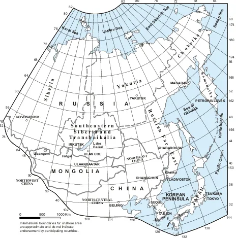
Northeast Asia project area consists of Eastern Russia (East-ern Siberia and the Russian Far East), Mongolia, North(East-ern China, the Korean Peninsula, Japan, and adjacent offshore areas (Fig. 1).
The summary of regional geodynamics and tectonics in this article is based upon publications of a major interna-tional collaborative study of the metallogenesis and tectonics of Northeast Asia and of the Circum-North Pacific, which were led by W. J. Nokleberg of the the US Geological Sur-vey. Two broad types of publications have been produced by this collaboration. One type is a series of regional geologic, mineral deposit, and metallogenic belt maps and companion descriptions for the region (Greninger et al., 1999; Obolen-skiy et al., 2003a, b, 2004; Parfenov et al., 2003, 2004a, b; Nokleberg et al., 1994, 1997a, b, c, 1998, 2004; Rodionov et al., 2004; and Naumova et al., 2006). The other type is a suite of metallogenic and tectonic analyses of these same regions (Nokleberg et al., 2000, 2005; Rodionov et al., 2004).
2 Definitions, geologic time scale, and tectonic environments
International boundaries for onshore area are approximate and do not indicate endorsement by participating countries.
0 500 1000 Km
96 Hatgal Lake Baikal Khanka Ulaangom VLADIVOSTOK KHABAROVSK CHANGCHUN TAEJON TOKYO TSUKUBA SEOUL BEIJING IRKUTSK ULAN UDE ULAANBAATAR YAKUTSK MAGADAN PETROPAVLOVSK NOVOSIBIRSK 64 68 72 76 80 82 40 44 48 52 56 90 40 102
108 114 120
126 132 138 144 150 156 162 168 174 180 174 32 36 56 75 60 64 68 72 76 80 82 52 78 84 48 60
M O N G O L I A
C H I N A R U S S I A
NORTH-CENTRAL CHINA NORTHWEST
CHINA
S ORT EA T N HINAH
C
C uk
ot k
h a KOREAN PENINSULA A JA P N Pa cf cO ea ii c n ig Be rn Se a ptev a La Se
Seaof Okho
tsk
K ur le I la n s i s d a S e a st ib rian Se E Kara l Sea
Y k i a ut a
S ri e a
ib
S o u t h e a s t e r n S i b e r i a a n d T r a n s b a i k a l i a
s s R u i a n F a r a c a K m h k t a a s t E
Figure 1 Fig. 1. Regional summary geographic map for Northeast Asia showing major regions and countries.
event; and (3) the understanding of the origins of major min-eral and hydrocarbon deposits related to the formations and modification of tectonic collages.
Definitions of other key terms for the analysis of regional geology and tectonics are provided in Table 1. These def-initions are adapted from Howell et al. (1985), Jones et al. (1983), and Nokleberg et al. (2000, 2005). Geologic time scale units are according to the IUGS Global Stratigraphic Chart (Remane, 1998). For this study and in some of the cited publications, the term Riphean is used for the Mesopro-terozoic to Middle NeoproMesopro-terozoic (1600 to 650 Ma), and the term Vendian is used for Neoproterozoic III (650 to 540 Ma).
(a)
Devonian aulacogene
Figure 2 - Map Riphean aulacogene
Thrust
Strike - slip fault
Fault Oceanic rift Contact Symbols, Faults, and Contacts
Overlap continental margin arc Transform continental margin arc Active subduction zone
2000 KM 1000
0
Kuril-Kamchatka
Arc
GY
GY
GY GY
GY GY NAC
NAC
SKC SKC
HS
HS BJ
HS HS KR
ST
Bering Sea
Pacific Ocean Laptev
Sea CS
VK
VK KOM
SA CH
oc
nb, ol
uy, ma
oc
oc
KOR
VR
OH
PA
WK
OK OK
PA
WK
OK EP
WS
CS EA
BP
AL
AL
AL
YT
YT
YT
YT YT
AR
AR TM
SM
SM AB
AB
SL
SL
SL JA
WD
BJ BJ
BJ
BJ BD
HS HS
ea
ji
sm sm
at at
ko
nm gh
lg
nr se
se
ha,
mt
se
ss
ss
ss
tr
tr
us
uo sv tr
MO CS
SH
JT
JT
NN ES
SH
ja
ja
ib
Sea of Okhotsk
Lake Baikal
East-Siberian Sea
kk
MO
MO
P A C I F I C P L A T E ES
ES MO
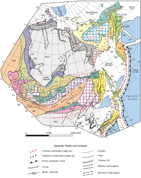
Fig. 2a. Northeast Asia summary geodynamics map. Map is derived from: (1) a generalized Northeast Asia geodynamics map at 10 million
(b)
EXPLANATION
Cratons and Craton Margins
Figure 2 - Explanation NAC - North Asian Craton (Archean and
Proterozoic);SKC - Sino-Korean Craton (Archean and Proterozoic)
Craton Margin: BP - Baikal-Patom (Riphean to Cambrian and older basement; EA - East Angara (Riphean and older basement; ST - South Taimyr (Ordovician to Jurassic); VR - Verkhoyansk (Devonian to Jurassic).
Tectonic Collages Between North Asian and Sino-Korean Cratons (older to younger)
Tectonic Collages Along Northern and Eastern Margins of North Asian and Sino-Korean Cratons (older to younger)
Active Subduction Zones
CS - Circum-Siberia (Proterozoic)
YT - Yenisey-Transbaikal (Vendian to Early Ordovician)
AL - Altay (Vendian to Ordovician) WD - Wundurmiao (Riphean to Ordovician) AB - Atasbogd ( ; SM - South Mongolia-Khingan (Ordovician to Carboniferous); WS - West Siberian (Ordovician to Carboniferous)
Ordovician through Permian)
MO - Mongol-Ohkotsk (Devonian to Late Jurassic); SL - Solon (Carboniferous to Permian)
CH - Chukotka (Paleozoic to Triassic)
BD - Badzhal (Triassic to Early Cretaceous); PA - Penzhina-Anadyr (Late Jurassic to Cretaceous); HS - Honshu-Sikhote-Alin (Jurassic to Early Cretaceous); SA - South Anyui (Permian to Jurassic);
VK - Verkhoyansk-Kolyma Paleozoic to Early Jurassic)
KOR - Koryak (Late Jurassic to Paleocene; SH - Sakhalin-Hokkaido (Cretaceous); WK - West Kamchatka (Mid-Cretaceous to Early Tertiary)
ES - East Sakhalin (Late Cretaceous to Early Tertiary); OK - Olyutorka-Kamchatka (Late Cretaceous to Paleocene)
Cratonal Terranes (Archean and Proterozoic): GY - Gyeonggi-Yeongnam; JA - Jiaonan; OH - Okhotsk
Cratonal Terranes (Archean and Proterozoic): GY - Gyeonggi-Yeongnam; JA - Jiaonan; OH - Okhotsk
Late Proterozoic to Cambrian Supterterranes; AR - Argun-Idermeg; TM - Tuva-Mongolia Archean to Permian Superterranes: BJ - Bureya-Jiamusi; KR - Kara
Jurassic Superterrane:
KOM - Kolyma-Omolon (Archean to Jurassic)
Oceanic crust Surficial units Sea and Ocean Units
Cratonal Terranes and Superterranes
Overlap Continental Margin Arcs and Granite Belts
- Altay arc (Devonian and early Carboniferous, 381-290 Ma)) East Sikhote-Alin arc (Late Cretaceous to early
Tertiary, 96-65 to Ma)
- arc
- Lugyngol arc (Permian, 295-250 Ma) - Hangay arc (
arc
arc
- Norovlin arc (Devonian, 410-255 Ma)
- Okhotsk-Chukotka arc (Late Cretaceous to early Tertiary, 96-53 Ma)
- arc - Selenga arc (
- South Mongolian arc (Middle Carboniferous through Triassic , 320-203 Ma)
- South Verkhoyansk granite belt (Late Jurassic to mid-Cretaceous, 157-93 Ma)
- Transverse granite belt (Early Cretaceous, 134-124 Ma) - Uda-Murgal and Stanovoy arc (
arc (Late Jurassic to Early Cretaceous, 154-120 Ma)
- arc Active Arcs
- Izu-Bonin (Late Cenozoic, 20-0 Ma) - Japan (Late Cenozoic, 23-0 Ma)
- Kuril-Kamchatka (Late Cenozoic, 11-0 Ma) at
ea
-gh lg ha
nr oc
ol se sm
sv
tr us
uo
ib ja kk
Gobi-Khankaisk-Daxing'anling (Permian, 295-250 Ma)
Late Carboniferous to Early Permian, 320-272 Ma) - Jihei (Permian, 295-250 Ma)
- Khingan-Okhotsk (Early and mid-Cretaceous) Main granite belt (Late Jurassic, 144-134 Ma) - Northern granite belt (Early Cretaceous, 138-120 Ma)
North Margin (Late Carboniferous to Permian, 320-272 Ma)
Oloy (Late Jurassic, 154-135 Ma)
Permian to Jurassic, 295-135 Ma)
Jurassic to Early Cretaceous, 203-96 Ma) - Uyandina-Yasachnaya
Umlekan-Ogodzhin (Cretaceous, 135-65 Ma) ji
ko ma nb nm
-uy
Transpressional Arcs
- Mongol-Transbaikal ( - South Siberian -
mt ss tr
Late Triassic to Early Cretaceous, 230-96 Ma) (Early Devonian, 415-400 Ma)
Trans-Baikalian-Daxinganling (Middle Jurassic through Early Cretaceous,175-96 Ma)
EP - East Kamchatka Peninsular (Mainly Paleocene)
JT- Japan Trench (including Kuril-Kamchatka trench) (Miocene to Present); NN - Nankai (Miocene to Present)
Table 1. Definitions of key terms for the regional geologic and tectonic analysis of Northeast Asia. Adapted from Jones et al. (1983), Howell
et al. (1985), and Nokleberg et al. (2000, 2003).
Term Definition
Accretion Tectonic juxtaposition of terranes to a craton or craton or continental margin. Accretion of terranes to one another or to a craton margin also definesa major change in the tectonic evolution of terranes and craton margins.
Accretionary-wedge Fragment of a mildly to intensely deformed complex consisting of varying amounts of turbidite deposits continental-margin,
terrane rocks, oceanic crust and overlying units, and oceanic mantle. Units are interpreted to have formed during tectonic
juxtaposition in a zone of major thrusting of one lithosphere plate beneath another, generally in zones of thrusting along the margin of a continent or an island arc. May include large fault-bounded fragments with a coherent stratigraphy. Many subduction-zone terranes contain fragments of oceanic crust and associated rocks that exhibit a complex structural history, occur in a major thrust zone, and possess blueschist-facies metamorphism.
Amalgamation Tectonic juxtaposition of two or more terranes before accretion to a continental margin.
Craton Chiefly regionally metamorphosed and deformed shield assemblages of Archean and Early Proterozoic sedimentary, volcanic,
and plutonic rocks, and overlying platform successions of Late Proterozoic, Paleozoic, and local Mesozoic and Cenozoic sedimentary and lesser volcanic rocks.
Continent A large section of continental crust surrounded by oceans on all sides, which consist, in its core, of one
or more cratons framed by younger tectonic collages (accretionary and collisional orogenic belts). Continental-margin Fragment of an igneous belt of coeval plutonic and volcanic rocks and associated
arc terrane sedimentary rocks that formed above a subduction zone dipping beneath a continent.
Inferred to possess a sialic basement.
Craton Chiefly regionally metamorphosed and deformed shield assemblages of Archean, Paleoproterozoic, and
Mesoproterozoic sedimentary, volcanic, and plutonic rocks, and overlying platform successions of Paleoproterozoic, Paleozoic, and local Mesozoic and Cenozoic sedimentary and lesser volcanic rock. Craton margin Chiefly Neoproterozoic to Jurassic sedimentary rocks deposited on a continental shelf or slope. Consists mainly
of platform successions. Locally has, or may have had an Archean and Early Proterozoic cratonal basement.
Cratonal terrane Fragment of a craton.
Island-arc system An island arc and tectonically linked subduction zone terranes.
Island-arc terrane Fragment of an igneous belt of plutonic rocks, coeval volcanic rocks, and associated sedimentary rocks that formed above an oceanic subduction zone. Inferred to possess a simatic basement.
Metamorphic terrane Fragment of a highly metamorphosed or deformed assemblage of sedimentary, volcanic, or plutonic rocks that cannot be assigned to a single tectonic environment because the original stratigraphy and structure are obscured. Includes intensely deformed structural melanges that contain intensely deformed fragments of two or more terranes.
Oceanic crust, Fragment of part or all of a suite of deep-marine sedimentary rocks, pillow basalt, gabbro, and ultramafic rocks (former eugeoclinal seamount, and eugeoclinal suite) that are interpreted as oceanic sedimentary and volcanic rocks and the upper mantle. Includes both inferred ophiolite terrane offshore oceanic and marginal ocean basin rocks, minor volcaniclastic rocks of magmatic-arc derivation, and major
marine volcanic accumulations formed at a hotspot, fracture zone, or spreading axis.
Overlap assemblage A postaccretion unit of sedimentary or igneous rocks deposited on, or intruded into, two or more adjacent terranes. Passive
continental-margin terrane Fragment of a craton (continental) margin.
Subduction zone terrane Fragment of a mildly to intensely deformed complex consisting of varying amounts of turbidite deposits,
continental-margin rocks, oceanic crust and overlying units, and oceanic mantle. Units are interpreted to have formed during tectonic juxtaposition in a zone of major thrusting of one lithosphere plate beneath another, generally in zones of thrusting along the margin of a continent or an island arc. May include large fault-bounded fragments with a coherent . stratigraphy Many subduction-zone terranes contain fragments of oceanic crust and associated rocks that exhibit a complex structural history, occur in a major thrust zone, and possess blueschist-facies metamorphism.
Superterrane A series of amalgamated terranes and/or a rifted fragment of a craton and (or) craton margin which exhibits
a long and complicated geologic history. May contain overlap island arc complexes and tectonically-linked subduction zones. Tectonic collage A series of linear island arcs or continental margin arcs and tectonically-linked (companion) subduction zones, and (or)
fore-arc and back-arc basins that formed in a major tectonic event during a relatively narrow geologic time span. The collages of igneous arcs and companion subduction zone terranes have been successively accreted to the margins of major cratons. The ages of collages with subduction zone units are for time of active formation of an accretionary wedge in a subduction zone, rather than the older range of units that comprise the accretionary wedge. A few collages consist of fragments of craton margin and cratonal terranes that were amalgamated before accretion to a continent.
Tectonic linkage A genetic relation of a continental margin arc or an island arc with a companion accretionary wedge that formed in a subduction zone that was adjacent to, and was underthrusting the arc.
Tectonostratigraphic An aggregate of terranes that is interpreted to share either a similar stratigraphic kindred or affinity, or a common geologic history after terrane (terrane) accretion (Jones and others, 1983; Howell and others, 1985). An approximate synonym is composite terrane (Plafker and Berg, 1994).
Terrane A fault-bounded geologic entity or fragment that is characterized by a distinctive geologic history that differs
markedly from that of adjacent terranes (Jones and others, 1983; Howell and others, 1985).
(2) passive continental margin; (3) metamorphosed continen-tal margin; (4) continencontinen-tal-margin arc and back-arc; (5) is-land arc and back-arc; (6) oceanic crust, seamount, or ophio-lite related to rifting and sea-floor spreading; (7) accretionary wedge and subduction zone; (8) turbidite basin; (9) colli-sional; (10) transform continental-margin faulting and asso-ciated bimodal volcanic-plutonic belt; (11) plume; and (12) metamorphic. For terranes with complex geologic and tec-tonic histories, the chosen tectec-tonic environment is the one that was the most prevalent during the history of the terrane. The reader should refer to the associated citations for more detailed descriptions of these terranes with complex histo-ries.
3 Compilation of regional geodynamics map
A regional geodynamics map was initially compiled at a scale of 1:5 000 000 (Nokleberg et al., 1997b, c; Parfenov et al., 2003, 2004a, b). However, in order to display ma-jor features of host rock geology and structures and mama-jor belts of mineral and hydrocarbon resources a page-size il-lustration, a summary regional geodynamics map (Fig. 2) was constructed at a scale of about 1:34 000 000 in order to display: (1) the regional surface extent of major geologic units (cratons, craton margins, tectonic collages of island arc, continental-margin arc, accretionary wedge, and passive con-tinental margin terranes, volcanic and plutonic igneous arcs); (2) major fault and rift systems; and (3) active subduction zones. A list of major host-rock geologic units in the expla-nation and a description of major geologic units for the map is provided in Appendix A. The tectonic interpretations for the summary map are derived from the major publications of the collaborative international studies on Northeast Asia and the Circum-North Pacific (listed above).
4 Methodology of regional geologic and tectonic analysis
The methodology employed for synthesizing the summary geodynamics map consisted of: (1) correlation of major ge-ologic units; (2) tectonic linking (pairing) of major geo-logic units; and (3) alignment of coeval arc and tectonically-linked subduction zones into curvilinear complexes. A sim-ilar methodology was utilized for a synthesis of the Circum-North Pacific (Nokleberg et al., 2000).
Initially, correlations are attempted for major geologic units which are interpreted as having been originally con-tiguous but were subsequently tectonically displaced during rifting, major thrusting, or along strike-slip faults. Correla-tions are attempted for all regional units (cratons, craton mar-gins, terranes, and overlap assemblages) that are understood to have the same tectonic origin, (i.e., as parts of a single elongate passive continental margin, continental-margin arc, island arc, or subduction zone) at the same geologic time and
originally on strike with each other. This correlation of ma-jor geologic units also illustrates the original continuity of rock units, provides important constraints on the past tecton-ics of the region, and provides a series of interpretations to be further evaluated by additional stratigraphic, geochemical, isotopic, paleomagnetic, and geophysical studies.
Following this step, tectonic linking (pairing) was based on pairing of: (1) subduction-related igneous arcs, now pre-served as various igneous-arc terranes or overlap assem-blages, with former subduction zones, now preserved as subduction-zone terranes; (2) belts of anatectic-related ig-neous rocks and major faults (sutures) that bound the col-lisional margins of terranes with each other or terranes with a craton margin; and (3) belts of igneous rocks that are coeval with, and occur along major transpressional fault zones.
The first type of tectonic linking can be based on: (1) rec-ognizing an original physical proximity between an arc and subduction zone; (2) determining the similarity in age of for-mation of an igneous-arc and subduction-zone terrane, (3) determining a subduction polarity from tectonic transport di-rection in a melange for subduction-zone terranes, where not disrupted by later deformation, and (4) recognizing the oc-currence of disrupted layers of arc-derived volcanic or vol-caniclastic units from a specific igneous arc in the melange of the linked subduction zone terrane.
A second type of tectonic linking is based on the spa-tial and temporal association of collisional (S-type) granitic plutons and associated volcanic rocks with: (1) major fault zones (sutures) between terranes or between a terrane and a craton margin; and (or) (2) belts of highly deformed, regional-grade metamorphic rocks that occur along the fault zones. Collision-related igneous belts are understood as forming either during accretion of one terrane to another or during the accretion of one or more terranes to a craton mar-gin.
A third type of tectonic linking is based on the spatial and temporal association of mainly intermediate and silicic igneous belts that are coeval with, and intrude along major transpressional fault zones.
5 Summary of regional geology and tectonics of Northeast Asia
The major regional geologic and tectonic units of North-east Asia are cratons, craton margins; cratonal terranes and superterranes; tectonic collages; overlap and transform continental-margin arcs; island arcs, and sea and ocean units (Fig. 2). Detailed descriptions of geologic units are pre-sented by Nokleberg et al. (2000) and Parfenov et al. (2004b). Abbreviations in parentheses in the following list of geo-logic units refer to units on the summary geodynamics map (Fig. 2). More detailed descriptions of map units are given in Appendix A. Two geologic ages are staged for each collage, one for the age of formation of the units in a collage, such, and another age for the time of accretion (formation) of the collage to another terrane, superterrane, or continent. 5.1 Major cratons and craton margins
The backstop or core units for the region of Northeast Asia are the Archean and Proterozoic North Asia Craton and Sino-Korean Craton and their Craton Margins (Baikal-Patom, An-gara, South Taimyr, and Verkhoyansk (North Asian)).
The North Asian Craton (NAC) consists of Archean and Proterozoic metamorphic basement, and non-deformed, flat-laying platform cover consisting of Late Precambrian, Pale-ozoic, and Mesozoic sedimentary and volcanic rock.
The Sino-Korean Craton (SKC) consists of several ma-jor Archean and Proterozoic metamorphic basement terranes and younger Paleozoic through Cenozoic overlap units.
The Baikal-Patom Craton Margin (BP) consists of a fault-bounded basin containing Riphean carbonate and terrigenous sedimentary rock, and younger Vendian and Cambrian sedi-mentary rock that discordantly overly a fragment of the pre-Riphean basement of the North Asian Craton.
The East Angara Craton Margin (EA) consists of Late Riphean terrigenous-carbonate sedimentary rock (sandstone, siltstone, mudstone with interlayered dolomite and lime-stone) that overlie a fragment of the North Asia Craton.
The South Taimyr Craton Margin (ST) consists chiefly of a thick wedge of Ordovician to Jurassic craton margin deposits and deep basin deposits.
The Verkhoyansk (North Asian) Craton Margin (VR) con-sists chiefly of a thick wedge of Devonian to Jurassic mio-geoclinal deposits.
5.2 Cratonal terranes and superterranes
Three cratonal terranes occur along the margins of the North Asian and Sino-Korean Cratons and are understood as rifted and reaccreted fragments of these cratons, in contrast to ex-otic terranes which are understood to be far travelled. The cratonal terranes are as follows. (1) The Okhotsk terrane (OH) terrane consists of Archean and Proterozoic gneiss and schist and Early and Middle Paleozoic miogeoclinal
sedimentary rock. The terrane is considered to be a fragment of the North Asian Craton and Margin that was rifted in the Late Devonian or Early Carboniferous. (2) The Gyenggi-Yeongnam terrane (GY) consists of two major Archean and Proterozoic basement rock terranes. The terrane is consid-ered to be a displaced fragment of the Sino-Korean Craton. (3) The last of these terranes is the Jiaonan cratonal terrane (JA) which consists of a Paleoproterozoic major high pres-sure terrane that is interpreted as a displaced fragment of the Sino-Korean Craton.
Six superterranes occur along the margins of the North Asian and Sino-Korean Cratons. Some of the superterranes are considered to be rifted and reaccreted fragments of the cratons whereas others are understtod to having formed else-where.
The Proterozoic to Cambrian Argun-Idermeg superterrane (AR) consists of the Paleoproterozoic to Late Paleozoic Ar-gunsky, Idermeg, and West Stanovoy metamorphosed pas-sive continental-margin terranes. The superterrane may be either exotic with respect to the North Asian Craton or may be a rifted fragment of the craton.
The Late Riphean and older Tuva-Mongolia superterrane (TM) consists of a series of Archean and Paleoproterozoic cratonal terranes (Gargan and Baydrag), the Snagilen pas-sive continental-margin terrane, and the Muya metamorphic terrane. These terranes are understood to have accreted to-gether to form the rear or back arc part of the Baikal-Myra island arc described below.
The Proterozoic to Permian Bureya-Jiamusi supterter-rane (BJ) consists of a collage of Early Paleozoic meta-morphic, continental-margin arc, subduction zone, passive continental-margin and island arc terranes. The superterrane is considered to be a fragment of Gondwana that was ac-creted to the Sino-Korean Craton in the Late Permian and accreted to the North Asian Craton in the Late Jurassic dur-ing final closure of the Mongol-Okhotsk Ocean.
The Proterozoic to Ordovician Kara superterrane (KR) consists of the Late Neoproterozoic to Ordovician Kara continental-margin turbidite terrane. The superterrane is un-derstood to be a rift fragment of the North Asian Craton that was reaccreted in the Jurassic.
5.3 Tectonic collages between North Asian and Sino-Korean Cratons
Between the North Asian and Sino-Korean Cratons are a se-ries of accreted tectonic collages composed primarily of Pa-leozoic island arcs and tectonically-linked subduction zones. These tectonic collages were accreted successively from north to south during successive closures of the Paleo-Asian, Solon, and Mongol-Okhotsk Oceans. Most of the tectonic collages contain one or more island arcs and tectonically-linked subduction zones. Because of successive terrane ac-cretions from north to south, the ages of collages generally young from north to south. However, this pattern is locally interrupted because some collages or parts of collages were interspersed because of subsequent strike-slip faulting.
The tectonic collages between the North Asian and Sino-Korean Cratons are as follows.
(1) The Circum-Siberia collage (CS) (Paleoproterozoic and Mesoproterozoic age and accreted in Neoproterozoic) consists of the Baikal-Muya island arc, the Near Yenisey Ridge island arc, and the Zavhan continental-margin arc, all of Neoproterozoic age, and small fragments of cratonal and metamorphic terranes of Archean and Proterozoic age. The three separate Neoproterozoic island arc systems formed south (present-day coordinates) of the North Asian Craton and Margin.
(2) The Yenisey-Transbaikal collage (YT) (Vendian to De-vonian age and accreted in Vendian to Early Ordovician) con-sists of the Vendian to Middle Cambrian Kuznetsk-Tannuola, Dzhida-Lake island arc terranes, tectonically-linked back-arc basins, and now tectonically-eroded subduction zone ter-ranes. The collage contains a linear array of island arc systems that formed south (present-day coordinates) of the North Asian Craton and Margin and previously accreted ter-ranes.
(3) The Altai collage (AL) (Vendian to Ordovician age and accreted in Late Silurian) consists of the Vendian to Early Ordovician Salair island arc and various fragments of arc-related turbidite terranes, subduction zone terranes, meta-morphic terranes derived from arc-related units, thick Cam-brian and Ordovician overlap turbidite units that formed on a continental slope and rise, and fragments of originally-adjacent oceanic terranes. The collage is an island arc sys-tem that was active near the southwest margin (present-day coordinates) of the North Asian Craton and Margin and previously-accreted terranes.
(4) The Wundurmiao collage (WD) (Mesoproterozoic to Silurian age and accreted in Late Silurian) consists of the Late Ordovician to Silurian Laoling island arc terrane, the Mesoproterozoic to Middle Ordovician Wundurmiao duction zone terrane, and the Neoproterozoic Seluohe sub-duction zone terrane. The collage contains the Laoling island arc system which formed near the Sino-Korean Craton. Both the island arc system and craton were widely separated from North Asian Craton in the Early Paleozoic.
(5) The Atasbogd collage (AB) (Ordovician to mian age and accreted in Late Carboniferous or Early Per-mian) consists of: the Ordovician to Permian Waizunger-Baaran terrane, the Devonian to Carboniferous Beitianshan-Atasbogd terrane, and the Paleoproterozoic to Permian Tsagaan Uul-Guoershan continental-margin arc terrane. The collage was a southwest continuation (present-day coordi-nates) of the South Mongolia-Khingan island arc that formed southwest and west (present-day coordinates) of the North Asian Craton and Margin and previously accreted terranes. The Atasbogd collage was initially separated from the North Asian Craton by a large back-arc basin.
(6) The South Mongolia-Khingan collage (SM) (Ordovi-cian to Carboniferous age and accreted in Late Carboniferous or Early Permian) consists of the South Mongolia-Khingan arc and tectonically-linked subduction zone terranes. The collage was a major island-arc system that formed southwest and west (present-day coordinates) of the North Asian Cra-ton and Margin and previously accreted terranes. The collage was separated from the North Asian Craton by a large back-arc basin.
(7) The West Siberian collage (WS) (Ordovician to Car-boniferous age and accreted in Late CarCar-boniferous or Early Permian) consists of the Late Silurian to Early Carboniferous Rudny Altai island arc, and the tectonically-linked Ordovi-cian to Early Carboniferous Kalba-Narim subduction zone terrane. The collage is a northwest continuation (present-day coordinates) of the South Mongolia-Khingan collage.
(8) The Mongol-Okhotsk collage (MO) (Devonian to Late Jurassic age and accreted in Late Paleozoic to Early Mesozoic) consists mainly of the Permian to Jurassic Se-lenga, Late Carboniferous and Early Permian Hangay, and Uda-Murgal and Stanovoy continental-margin arcs. These arcs are composed of continental-margin igneous over-lap assemblages, continental-margin turbidite terranes, and tectonically-linked, outboard subduction zone terranes. The arcs overlap the southern margin of the North Asian Craton and Margin, and previously-accreted terranes. The collage formed during long-lived closure of the Mongol-Okhotsk Ocean with oblique subduction of terranes beneath of south-ern North Asian Craton Margin and previously-accreted ter-ranes.
the North Margin continental-margin arc on the Sino-Korean Craton.
5.4 Tectonic collages east of North Asian and Sino-Korean Cratons
To the east of the North Asian and Sino-Korean Cratons are a series of tectonic collages that were successively ac-creted from west to east (older to younger) during closures of parts of the Ancestral Pacific and modern Pacific Oceans, and older oceans in the region. Because of successive accre-tions from west to east, the ages of collages generally young from west to east. However, this pattern is locally disrupted because some collages have been tectonically disrupted and interspersed by subsequent strike-slip faulting
Except for the Verkhoyansk-Kolyma and Chukotka col-lages, the other tectonic collages contain one or more island arcs or continental-margin arcs and tectonically-linked sub-duction zones. The tectonic collages that occur east of the North Asian and Sino-Korean Cratons are the following.
(1) The Verkhoyansk-Kolyma collage (VK) (Late Paleo-zoic to Early Jurassic age and accreted in Late Jurassic to Early Early Cretaceous) consists of a deformed passive con-tinental margin, accreted ophiolites, and subduction zone and formed during accretion of the outboard Kolyma-Omolon su-perterrane.
(2) The Chukotka collage (CH) (Paleozoic to Triassic age and accreted in Late Jurassic to Early Cretaceous) consists of passive continental-margin terranes that formed along the long-lived Neoproterozoic to Early Mesozoic North Amer-ican Continental Margin. After subsequent rifting of the North American Craton Margin in the Late Jurassic and Early Cretaceous and translation, the collage was accreted to the northern Verkhoyansk-Kolyma collage in the Late Creta-ceous.
(3) The South Anyui collage (SA) (Permian to Early Juras-sic age and accreted in Late Cretaceous) consists of the Oloy island arc and tectonically-linked subduction zone terranes.
(4) The Penzhina-Anadyr collage (PA) (Late Jurassic to Early Cretaceous age and accreted in Late Cretaceous) con-sists of the Murgal island arc terrane and tectonically-linked subduction zone terranes to the east. The collage rims the eastern Kolyma-Omolon superterrane and Verkhoyansk-Kolyma collage. The collage is also linked to the Uda continental-margin arc.
(5) The Badzhal collage (BD) (Triassic to Early Creta-ceous age and accreted in Late CretaCreta-ceous) consists of the Umlekan continental-margin arc and tectonically-linked sub-duction zone terranes to the east with Tethyan fauna.
(6) Honshu-Sikhote-Alin collage (HS) (Jurassic and Early Cretaceous age and accreted in Cretaceous). This collage consists of fragments of island arc, continental-margin tur-bidite (flysch), and subduction zone terranes. The collage formed along a transform continental margin.
(7) The Koryak collage (KOR) (Late Triassic to Creta-ceous age and accreted in Late CretaCreta-ceous) consists of the Late Jurassic and Early Cretaceous Manitskiy island arc and tectonically-linked subduction zone terranes to the east.
(8) The Sakhalin-Hokkaido collage (SK) (Cretaceous age and accreted in Eocene) consists of the Late Creta-ceous flysch terranes of Sakhalin and Hokkaido Islands, and tectonically-linked subduction zone terranes to the east. The collage formed a continental-margin fore-arc basin and tectonically-linked subduction zone terranes that are associ-ated with the East Sikhote-Alin continental-margin arc.
(9) The West Kamchatka collage (WK) (Mid-Cretaceous to Early Tertiary age and accreted in Early Cenozoic) con-sists of Late Paleozoic to Cretaceous subduction zone ter-ranes in the Russian Northeast. The collage was tectonically linked to Okhotsk-Chukotka continental-margin arc.
(10) The East Sakhalin collage (ES) (Late Cretaceous to Early Tertiary age and accreted in Early Tertiary) consists of the Late Cretaceous to Middle Eocene Terpeniy-Tokoro-Nemuro-Shmidt island arc and tectonically-linked subduc-tion zone terranes.
(11) The Olyutorka-Kamchatka collage (OK) (Late Cre-taceous and Paleocene age and accreted in Early Cenozoic) consists of the Olyutorka island arc and tectonically-linked subduction zone terranes to the east.
(12) The East Kamchatka Peninsula collage (EP) (mainly Paleocene age and accreted in Pliocene) consists of the Kro-notskiy island arc and associated ophiolite.
5.5 Carboniferous and Permian overlap continental-margin arcs occurring south of North Asia Craton and on Sino-Korean Craton
Several major overlap continental-margin arcs occur only on previously-accreted terranes south of the North Asian Cra-ton and on the Sino-Korean CraCra-ton. These arcs are related to subduction of the Late Paleozoic and Early Mesozoic Solon Ocean plate beneath the North Asian and Sino-Korean Cra-tons. This ocean occurred (in present-day geographic coordi-nates) between the Argun-Idermeg superterrane to the north and the Sino-Korean Craton to the south. The arcs are de-scribed progressing from older to younger.
(1) The Altay arc (at) (Devonian and Early Carboniferous) occurs on the Altay and Yenisey-Transbaikal collages. The arc formed along an active continental margin in an oblique subduction zone environment.
(2) The Gobi-Khankaisk-Daxing’anling arc (gh) (Per-mian) occurs on the Argun-Idermeg superterrane, South Mongolian collage, and Solon collage. The arc formed dur-ing subduction of the northern part of Solon Ocean plate under the southern margin (present-day coordinates) of the Argun-Idermeg superterrane.
subduction of the northern part of Solon Ocean plate under the Argun-Idermeg superterrane.
(4) The Lugyngol arc (lg) (Permian) occurs on the South Mongolian and Solon collages. The arc is formed during subduction of the northern part of Solon Ocean plate under the southern margin (present-day coordinates) of the Argun-Idermeg superterrane.
(5) The Jihei arc (ji) (Permian) occurs on the South Mongolia-Khingan collage. The arc intrudes the Bureya-Jiamusi superterrane and South Mongolia-Khingan collage and formed during subduction of the northern part of Solon Ocean plate under the southern margin (present-day coor-dinates) of the Bureya-Jiamusi supterterrane and adjacent units.
(6) The North Margin arc (nm) (Late Carboniferous to Permian) occurs on the northeastern margin (present-day co-ordinates) of Sino-Korean Craton. The arc formed during subduction of the southern part of Solon Ocean plate under the northeastern margin (present-day coordinates) of Sino-Korean Craton.
5.6 Devonian to Early Cretaceous overlap continental-margin arcs occurring along Southeastern Margin of the North Asian Craton and adjacent accreted terranes
Several major overlap continental-margin arcs occur along the southeastern margin of the North Asian Craton or on ad-jacent accreted terranes. The arcs are related to subduction of the Late Paleozoic and early Mongol-Okhotsk Ocean plate beneath the North Asian Craton and Margin. This ocean oc-curred between the North Asian Craton to the north and the Argun-Idermeg superterrane to the south (present-day coor-dinates).
(1) The Norovlin arc (nr) (Devonian to Early Carbonifer-ous) occurs on the Argun-Idermeg superterrane (Amur mi-crocontinent – Argunsky and Idermeg passive continental-margin terranes). The arc is formed during subduction of the Mongol-Okhotsk Ocean plate beneath northern margin (in present-day geographic coordinates) of the Argun-Idemeg superterrane (Amur microcontinent).
(2) The Hangay arc (ha) (Late Carboniferous to Early Permian) occurs on the Yenisey-Transbaikal collage and Mongol-Okhotsk collage. The arc formed during subduction of the northern part of Mongol-Okhotsk Ocean plate under the North Asian Craton Margin and previously-accreted ter-ranes.
(3) The Selenga arc (se) (Permian to Jurassic) overlies and intrudes the Yenisey-Transbaikal collage and Tuva-Mongolia superterrane. The arc formed during oblique subduction of the Mongol-Okhotsk Ocean plate under the North Asian Cra-ton Margin and previously-accreted terranes.
(4) The Uda-Murgal and Stanovoy arcs (us) (Jurassic to Early Cretaceous) occur on the southern margin of the North
Asian Craton. The arcs formed during final stage of subduc-tion of the Mongol-Okhotsk Ocean plate.
5.7 Jurassic and Early Cretaceous overlap island arcs occurring on or adjacent to Kolyma-Omolon superterrane
The major overlap island arcs occurring on the Kolyma-Omolon superterrane are the Late Jurassic to Early Creta-ceous Uyandina-Yasachnaya island arc and the Late Jurassic Oloy island arc.
(1) The Uyandina-Yasachnaya arc (uy) (Late Jurassic to Early Cretaceous) occurs along the margin of the Kolyma-Omolon superterrane. The arc formed during subduction of the Oimyakon Ocean plate between the North Asian Craton Margin and the Kolyma-Omolon superterrane. Remnants of the Oimyakon oceanic crust are preserved in small obducted ophiolites along the western margin of superterrane. This ocean occurred between the Verkhoyansk (North Asian) Cra-ton Margin to the southwest and the Kolyma-Omolon to the northeast (present-day coordinates).
(2) The Oloy arc (ol) (Late Jurassic) occurs along the mar-gin of the Kolyma-Omolon superterrane. The arc formed on the Kolyma-Omolon superterrane during subduction of the South Anyui Ocean plate beneath the superterrane to form the South Anyui subduction-zone terrane. This ocean formed north of the Kolyma-Omolon superterrane (present-day coor-dinates).
5.8 Jurassic through Early Tertiary overlap continental-margin arcs and granite belts occurring along eastern margin of Northern Asia A series of Jurassic through Early Tertiary overlap continental-margin arcs and granite belts occur along the eastern margin of the North Asian and Sino-Korean Cratons and outboard accreted terranes to the east. From older to younger, the arcs and belts are as follows.
(1) The Umlekan-Ogodzhin arc (uo) (Jurassic and Creta-ceous) occurs along the margin of the Kolyma-Omkolon su-perterrane. The arc formed during subduction of the Ances-tral Pacific Ocean plate to form the Badzhal and Nadanhada terranes in the Badzhal collage.
(2) The South Verkhoyansk Granite Belt (sv) (Late Juras-sic to Mid-Cretaceous) occurs in the Central Russian Far East. The belt extends longitudinally along the central part of the South Verkhoyansk synclinorium in the Verkoyansk (North Asian) Craton Margin. The belt formed during the accretion of the outboard Okhotsk terrane.
(4) The Transverse Granite Belt (tr) (Early Cretaceous) ra-diates outwards from the southwestern bend of the Kolyma-Omolon superterrane. The belt formed during the late stage of accretion of Kolyma-Omolon superterrane.
(5) The Northern Granite Belt (nb) (Early Cretaceous, 138 to 120 Ma) occurs along northwestern margin of the Kolyma-Omolon superterrane. The belt formed during the subduction of oceanic crust during a closure of a small oceanic basin dur-ing late stage of accretion of Kolyma-Omolon superterrane.
(6) The Khingan-Okhotsk arc (ko) (Early and Mid-Cretaceous) occurs in the Russian Southeast and consists of the Khingan-Okhotsk volcanic-plutonic belt. The arc was tectonically paired to the Early Cretaceous Zhuravlevsk-Amur River and Kiselevka-Manoma subduction-zone ter-ranes that are both part of the Honshu-Sikhote-Alin collage.
(7) The Okhotsk-Chukotka arc (oc) (Late Cretaceous to Early Tertiary) occurs along the eastern margin of the Central and Northern Russian Far East. The arc formed during sub-duction of the Ancestral Pacific Ocean plate and formation of the West Kamchatka, Ekonay, and Yanranay subduction zone terranes.
(8) The East Sikhote-Alin arc (ea) (Late Cretaceous to Early Tertiary) occurs along the margin of the Southern Rus-sian Far East. The arc formed during subduction of the Ancestral Pacific Ocean plate with formation of the older part of the Hidaka subduction zone, the younger part of the Aniva subduction-zone terrane, and the Nabilsky, and Tokoro subduction-zone terranes.
5.9 Active overlap continental-margin arcs
occurring along eastern margin of Northern Asia Three active overlap continental-margin arcs occur along the eastern margin of the North Asian and Sino-Korean Cratons and outboard accreted terranes to the east.
(1) The Izu-Bonin arc (ib) (Miocene through Present) oc-curs south of Southern Japan and consists of a volcanic arc composed chiefly of basalt to rhyolite, associated volcani-clastic rock, and intercalated hemipelagic mudstone. The arc is formed during subduction of the Philippine Sea Plate with formation of the Nankai subduction zone. (2) The Japan arc (ja) (Miocene through Present) occurs along the Japanese Is-lands and consists of extensive Quaternary volcanic and as-sociated rock. The arc is formed during subduction of the Pacific Ocean and Philippine Sea Plates with formation of the Japan Trench and Nankai subduction zones.
(3) The Kuril-Kamchatka arc (kk) (Miocene through Present) occurs along Kamchatka Peninsula and Kuril Is-lands and consists of the Pliocene to Quaternary Central Kamchatka volcanic belt, Central Kamchatka volcanic and sedimentary basin, and the East Kamchatka volcanic belt. The arc is formed during subduction of the Pacific Ocean Plate and formation of the Japan Trench subduction zone.
5.10 Transpressional arcs (Devonian through Cretaceous)
Three major transpressional arcs occur along the margins of the North Asian Craton and previously accreted terranes to the south. The arc formations are associated with strike-slip faulting that is sometimes associated with local compression and extension.
(1) The South Siberian arc (ss) (Early Devonian) occurs in Southern Siberia. The arc is formed along the south-ern margin of the North Asian Craton and Craton Margin during Early Devonian rifting that successively evolved into a continental-margin transform margin and subsequently into a convergent margin.
(2) The Mongol-Transbaikal arc (mt) (Late Triassic to Early Cretaceous) occurs in Northern Mongolia and South-ern Siberia. The arc is formed during strike-slip faulting and rifting along the Mongol-Okhotsk fault during and after the final closure of the Mongol-Okhotsk Ocean.
(3) The Trans-Baikal-Daxinganling arc (tr) (Middle Juras-sic through Early Cretaceous) occurs in Southern Siberia, Mongolia, Northeastern China. The arc formed during strike-slip faulting and rifting along the Mongol-Okhotsk fault during, and after the final closure of the Mongol-Okhotsk Ocean.
6 Conclusions
Compiled with the methodology described herein, the North-east Asia summary geodynamics map (Fig. 2) illustrates the power of a regional map and provides an example for fu-ture regional studies of large parts of the earth’s continental crust. This map greatly benefits the interpretation of origins of major rock units, major structures, and mineral and hydro-carbon resources, and provides important guidelines for new research.
Appendix A
Description of map units for Northeast Asia summary geodynamics map
A1 Introduction
A2 Cratons
NAC – North Asian Craton (Archean and Proterozoic). Con-sists of Archean and Proterozoic metamorphic basement, and non-deformed, flat-laying platform cover consisting of Late Precambrian, Paleozoic, and Mesozoic sedimentary and volcanic rock. Cover locally ranges up to 14 000 m thick. Metamorphic basement exposed in the Aldan-Stanovoy and Anabar shields located near southern and northern craton margins, respectively. Along the southwestern margin of the craton is a narrow band of basement rocks named the Near-Sayan Uplift. Within the Aldan-Stanovoy and Anabar shields and the Near-Sayan Uplift are several terranes composed of Early Precambrian crystalline rocks of varying composition and structural style. Four sequences comprise the platform cover: (1) Vendian and Early Paleozoic; (2) Middle Paleo-zoic; (3) Late PaleoPaleo-zoic; and (4) Mesozoic. Each stage is characterized by a unique structural style and unique suite of sedimentary and magmatic rocks. The sequences are sepa-rated from each other by regional discontinuities and uncon-formities that are related to major tectonic events.
SKC – Sino-Korean Craton (Archean and Proterozoic). Consists of several major terranes and younger overlap units in Northern China and in the northern Korean Penin-sula. The Archean and Proterozoic metamorphic base-ment is composed of various major terranes and first overlap units: (1) Paleoproterozoic Alashan granulite-paragneiss terrane in Northwestern China; (2) Archean Er-duosi Granulite-paragneiss terrane in North-Central China; (3) Archean Yinshan granite-greenstone terrane and first overlapped Zhangbei-Bayan Obo-Langshan metasedimen-tary and metavolcanic rocks (Paleo-Mesoproterozoic) in North-Central China; (4) Archean Jilin-Liaoning-East Shan-dong tonalite-trondhjemite-gneiss terrane and overlapped, metamorphosed and deformed rocks of East Shandong-East Liaoning-East Jilin rift or foreland basin (Paleoproterozoic) in Northeastern China; (5) Archean West Liaoning-Hebei-Shanxi granulite-orthogneiss terrane and overlapped, meta-morphosed and deformed rocks of Hutuo rift basin (Pale-oproterozoic) in Northern China; (6) Archean to Paleopro-terozoic Machollyong granulite-paragneiss terrane in North-ern Korean Peninsula; and (7) Archean Rangnim granulite-paragneiss terrane in Northern Korean Peninsula. Overlap units are extensive Proterozoic and Paleozoic continental-margin sedimentary rock and lesser volcanic rock; and ex-tensive Mesozoic and Cenozoic marine and terriginous sedi-mentary rock units, and volcanic and plutonic arc rock units. A3 Craton margins
BP – Baikal-Patom Craton Margin (Riphean to Cambrian and older basement). Consists of a fault-bounded basin con-taining Riphean carbonate and terrigenous sedimentary rock, and Younger Vendian and Cambrian sedimentary rock that discordantly overly a fragment of pre-Riphean basement of
the North Asian Craton. Local detritus suggests derivation from ophiolite and island arc complexes of the Bakal-Muya terrane during accretion to the craton. Local greenschist and amphibolite facies regional metamorphism with isotopic ages of about 800 Ma.
EA – East Angara Craton Margin (Riphean and older base-ment). Consists of Late Riphean terrigenous-carbonate sed-imentary rock (sandstone, siltstone, mudstone with interlay-ered dolomite and limestone) that overlie a fragment of the North Asia Craton. Metamorphosed up to greenschist facies. Unconformably overlapped by Late Riphean and Vendian molasse and Vendian and Cambrian dolomite and limestone. ST – South Taimyr Craton Margin (Ordovician to Juras-sic). Consists chiefly of a thick wedge of craton margin deposits and deep basin deposits ranging up to 20 000 m thick. Composed chiefly of Ordovician to Jurassic clastic rock, shallow-marine terrigenous and carbonate rock, and mafic volcanic and volcaniclastic rock. Late Carboniferous and Permian sedimentary rocks contain extensive sills and dikes of the Early Triassic trap subalkaline and alkaline di-abase. The terrane is tectonically detached from the crys-talline basement of the North Asian Craton but was subse-quently accreted back onto the craton.
VR – Verkhoyansk (North Asian) Craton Margin (Devo-nian to Jurassic). Consists chiefly of a thick wedge of cra-tonal margin deposits ranging up to 20 000 m thick. Ma-jor units are Carboniferous, Permian, Triassic, and Early and Middle Jurassic clastic rock, and marine-littoral, deltaic, and shelf sedimentary rock deposited on the Verkhoyansk pas-sive continental margin of the North Asian Craton. Major units grade successively eastward into turbidite deposits and deep-water black shale. Also occurring are: (1) local Mid-dle to Late Devonian and Early Carboniferous, rift-related deposits similar to those on the Siberian Platform; and (2) local Early Triassic and Early Jurassic alkalic basalt flows, dikes, and sills. Northern and southern parts of craton margin contain thick, Neoproterozoic and Early Paleozoic shallow-marine carbonate and clastic deposits that are finer-grained and thicker to east. The terrane is tectonically detached from the passive continental margin and crystalline basement of the North Asian Craton.
A4 Cratonal terranes
JA – Jiaonan cratonal terrane (Proterozoic). Consists of a Paleoproterozoic major high pressure terrane that is a dis-placed fragment of the South China (Yangtzi) Craton. Lo-cally overlain by extensive Paleozoic continental margin sed-imentary rock and lesser volcanic rock, extensive Mesozoic and Cenozoic marine and terriginous sedimentary rock units, and volcanic and plutonic arc units.
OH – Okhotsk cratonal terrane (Archean, Proterozoic, and Early and Middle Paleozoic). Consists chiefly of large blocks of Archean to Paleoproterozoic gneiss and schist with a U-Pb zircon age of 3.7 Ga. Overlain by: (1) gently-dipping, shallow-marine Middle and Neoproterozoic clastic and car-bonate rock; (2) Early Cambrian limestone, marl, and sand-stone; (3) Early Ordovician conglomerate, limestone, marl, and sandstone; and (4) unconformably overlying Middle De-vonian limestone, sandstone, shale, and conglomerate, and Late Devonian rhyolite, ignimbrite, andesite, dacite, and tuff that are interlayered with nonmarine sandstone, siltstone, and conglomerate. Overlying units are Carboniferous to Late Jurassic nonmarine and rare marine clastic rock. The terrane is interpreted as a fragment of the North Asian Craton and Craton margin that was rifted in the Late Devonian or Early Carboniferous and accreted to the Eastern Asia continental margin in the Late Jurassic.
A5 Superterranes
AR – Argun-Idermeg superterrane (Proterozoic to Cambrian; Timing of accretion – Late Neoproterozoic to Cambrian). Consists of: (1) Paleoproterozoic to Late Paleozoic Argun-sky metamorphosed passive continental margin terrane (AR) (Eastern Mongolia, Northeastern China, Transbaikalia); (2) Proterozoic to Cambrian Idermeg metamorphosed passive continental margin terrane (ID) (Eastern Mongolia); and (3) West Stanovoy metamorphosed continental margin terrane (WST) (Archean through Neoproterozoic) (Transbaikalia, Mongolia). The superterrane metamorphosed at greenschist to upper amphibolite to granulite facies.
BJ – Bureya-Jiamusi supterterrane (Proterozoic to Per-mian; Timing of accretion – Early Paleozoic). Consists of an Early Paleozoic collage with fragments of the follow-ing metamorphic, continental-margin arc, subduction zone, passive continental-margin and island arc terranes: (1) Neo-proterozoic to Triassic Bureya terrane (BU) (the Southern Russian Far East); (2) Neoproterozoic and older and Early Cambrian Jiamusi terrane (JI) (Northeastern China); (3) Pro-terozoic Matveevka terrane (MT) (the Southern Russian Far East); (4) Proterozoic Nakhimovka terrane (NK) (the South-ern Russian Far East); (5) Silurian to Permian(?) South Kitakami metamorphosed island arc terrane (SK) (Northern Honshu Island, Japan); and (6) Late Carboniferous and Per-mian Laoyeling-Grodekov island arc terrane (LG) (North-eastern China, the Southern Russian Far East); (7) Cambrian through Permian passive continental-margin Voznesenka ter-rane (the Southern Russian Far East); (8) Cambrian(?) and
Ordovician(?) Sergeevka island arc terrane (SG) (the South-ern Russian Far East); (9) Neoproterozoic through Devo-nian Zhangguangcailing continental-margin arc terrane (ZN) (Northeastern China); (10) Ordovician and Silurian Hei-longjiang subduction zone, type B terrane (HE) (Northeast-ern China); (11) Archean through Middle Triassic Urmi pas-sive continental margin terrane (UR) (Northeast China, the Southern Russian Far East); and (12) Late Carboniferous and Permian Tumangang island arc terrane (TB) (Korea). These terranes are derived from a series of Late Precambrian vol-canic units, and Late Precambrian to Ordovician shallow ma-rine clastic and carbonate rock. Local amphibolite and gran-ulite facies metamorphism of Early and Middle Ordovician age (480 to 500 Ma). Units intruded by Cambrian and Or-dovician granitoids and unconformably overlain by Devo-nian rock.
The superterrane is interpreted as a fragment of Gondwana that was accreted to the Sino-Korean Craton in the Late Per-mian and accreted to the North Asian Craton in the Late Jurassic during closure of the Mongol-Okhotsk ocean. The superterrane may be a fragment of the Yenisey-Transbaikal orogenic belt that also contains Early Paleozoic granulite facies metamorphism and Cambrian and Ordovician grani-toids.
KR – Kara superterrane (Proterozoic to Ordovician; Tim-ing of accretion – Early Paleozoic(?). Consists of a Late Neoproterozoic to Ordovician Kara continental-margin tur-bidite terrane (KR) (northern part of Taimyr Peninsula). The terrane contains mainly Late Riphean turbidite units metamorphosed up to amphibolite facies. Uppermost tur-bidites contain Cambrian and Early Ordovician fauna. Tur-bidites are unconformably overlain by Ordovician-Devonian littoral-marine and continental sedimentary rock. The supert-errane accreted to the North Asian Craton (with genesis of) generating Middle Permian two-mica and biotite-amphibole granite and granodiorite (with U-Pb, Rb-Sr, and incremental Argon isotopic ages of 264 to 252 Ma). Granitoids comprise an extensive belt that obliquely cuts the superterrane and the margin of the Late Riphean Circum-Siberian collage. The superterrane is interpreted as a rifted fragment of the North Asian Craton that was reaccreted in the Jurassic.
Alazeya island arc. Obduction of oceanic crust and forma-tion of small ophiolite fragments of the Munilkan terrane were associated with this process. The superterrane is uncon-formably overlain by the Late Jurassic Uyandina-Yasachnaya superterrane marginal arc (uy) under which the Oimyakon ocean basin was subducted during migration of superter-rane towards the North Asia (Verkhoyansk) Craton Margin. The superterrane was accreted to the northeast Verkhoyansk (North Asian) Craton Margin in the Late Jurassic to Early Cretaceous. The accretion resulted in formation of colli-sional granites of the Main (mb) (Late Jurassic) and Northern (nb) (Early Cretaceous) granite belts (Yakutia).
TM – Tuva-Mongolia superterrane (Late Riphean and older; Timing of accretion – Late Neoproterozoic). Con-sists of many fragments of the: (1) Archean and Paleo-proterozoic Gargan cratonal terrane (GG) (North Huvsgol, Mongolia, Eastern Sayan); (2) Proterozoic Sangilen passive continental-margin terrane (SA) (Southwest Siberia, Mon-golia); (3) Neoproterozoic and older Baydrag cratonal ter-rane (BY) (Northwest Mongolia); and (4) Late Archean(?) and Paleoproterozoic(?) Muya metamorphic terrane (MS) (Transbaikalia). The superterrane also includes the various terranes of the Baikal-Muya island arc system (Baikal-Muya, Barguzin, Dibinsky, Hug, Ilchir, Kuvai, Olokit-Delunuran, and Sarkhoy terranes) that were amalgamated to form the Tuva-Mongolian microcontinent. The superterrane is un-conformably overlain by Vendian and Cambrian sedimentary and volcanic rock.
A6 Tectonic collages accreted between North Asian and Sino-Korean Cratons (Proterozoic to Early
Mesozoic accretions
AB – Atasbogd collage (Ordovician to Permian; Timing of accretion – Late Carboniferous or Early Permian). Con-sists of: (1) Ordovician to Permian Waizunger-Baaran ter-rane; (2) Devonian to Carboniferous Beitianshan-Atasbogd terrane; and (3) Paleoproterozoic to Permian Tsagaan Uul-Guoershan continental-margin arc terrane; The collage is a southwest continuation (present-day geographic coordinates) of the South Mongolia-Khingan island arc. Units in the col-lage are unconformably overlain by Permian volcanogenic and coal-bearing units. The collages comprising the arcs were accreted to the southern margin of the Siberian con-tinent in the Late Carboniferous or Early Permian (320 to 300 Ma).
AL – Altai collage (Vendian to Ordovician; Timing of accretion – Late Silurian). Consists of Vendian to Early Ordovician Salair island arc and various fragments of arc-related turbidite, and subduction zone terranes, metamor-phic terranes derived from arc-related units, and thick Cam-brian and Ordovician overlap turbidite units formed on con-tinental slope and rise, and fragments of originally-adjacent oceanic terranes are the major units in the collage. The collage is an island arc system that lay near the southwest
margin (present-day coordinates) of the North Asian Craton and Margin and previously-accreted terranes. These units oc-cur in the Gorny Altai, West Sayan, Central and Northwest-ern Mongolia, and adjacent regions of NorthNorthwest-ern China.
The Salair island arc (Vendian-Early Ordovician) is pre-served in various fragments in Southwestern Siberia in the: (1) Early Cambrian to Early Ordovician Salair island arc terrane; (2) the Cambrian Ulus-Cherga island arc terrane; and (3) Early and Middle Cambrian Sugash terrane. The tectonically-linked subduction zone and oceanic crust units are the: (1) Vendian and Early Cambrian Alambai subduction zone terrane; and (2) Late Neoproterozoic to Early Cambrian Baratal subduction zone terrane.
The arc is also preserved in various fragments in the fol-lowing metamorphic (arc-related) terranes: Middle Silurian and older Angurep terrane; Late Permian and older Be-lokurikha terrane; and Mesoproterozoic and Neoproterozoic Qinghe-Tsel terrane.
The arc is also preserved in various fragments of the fol-lowing continental-margin turbidite terranes: Early to Late Paleozoic Anui-Chuya terrane; Precambrian and Cambrian to Devonian Altai terrane; Cambrian to Devonian Charysh terrane; Late Neoproterozoic to Devonian West Sayan ter-rane; and Neoproterozoic through Silurian Hovd terrane.
The arc is tectonically linked to various fragments in the following subduction zone terranes: Early Paleozoic or older Kaitanak terrane; Middle Devonian or older Maralikha ter-rane; Late Neoproterozoic through Early Cambrian Terekta terrane; and Late Neoproterozoic to Early Cambrian Baratal terrane.
The arc is also tectonically linked to various fragments of the following oceanic terranes: Late Neoproterozoic and Early Cambrian Mogen-Buren terrane; Late Cambrian and Early Ordovician Zasurin terrane; and Late Neoproterozoic and Early Cambrian Saratan terrane.
The timing of the accretion of the collage to the Siberian continent is constrained by an angular unconformity at the base of the Upper Silurian or Devonian units and by oro-genic granitoid magmatism of Early Devonian or older (pre-Emsian) age (about 435–415 Ma).
the North Asian Craton and Craton Margin occurred in the Late Neoproterozoic.
Baikal-Muya island arc (Neoproterozoic). Preserved in various fragments in the: (1) Paleoproterozoic to Early Cam-brian Hamar-Davaa metamorphic terrane (metamorphosed forearc prism); (2) Neoproterozoic Baikal-Muya island arc terrane; (3) Late Neoproterozoic Barguzin metamorphic ter-rane (metamorphosed forearc prism); and (4) Late Neo-proterozoic Sarkhoy island arc terrane. The tectonically-linked subduction zone or subduction zone units are the: (1) Paleoproterozoic to Neoproterozoic Olokit-Delunuran subduction zone terrane; (2) Neoproterozoic Hug subduction zone terrane; and (3) Neoproterozoic Kuvai subduction zone terrane.
Near Yenisey Ridge island arc (Neoproterozoic). Pre-served in various fragments in the: (1) Neoproterozoic Isakov island arc terrane; (2) Late Neoproterozoic Predivinsk island arc terrane; and (3) Neoproterozoic Chelyuskin island arc terrane.
Zavhan continental-margin arc (Neoproterozoic). Pre-served in various fragments in Northern Mongolia in the: (1) Late Neoproterozoic Zavhan continental-margin arc terrane; and (2) Neoproterozoic Tasuul oceanic terrane.
Cratonal and Metamorphic terranes (Archean and Protero-zoic). Consists mainly of relatively small (tens of kilometers wide) fragments preserved in the: (1) Archean and Paleopro-terozoic Gargan cratonal terrane; (2) Late Archean(?) and Paleoproterozoic(?) Muya metamorphic terrane; and (3) Pa-leoproterozoic Kan cratonal terrane. The terranes are frag-ments of the North Asian Craton and that were rifted away during the breakup of the Rodinia supercontinent. These cratonal and metamorphic terranes formed a tectonic back-stop for the accretion of the Neoproterozoic island arcs in the Circum-Siberia collage.
MO – Mongol-Okhotsk collage (Devonian to Late Juras-sic; Timing of accretion – Late Paleozoic to Early Meso-zoic). Consists mainly of Middle to Late Paleozoic and Early Mesozoic Selenga, Hangay, and Uda-Murgal and Stanovoy continental-margin arcs composed of continental-margin ig-neous overlap assemblages, continental-margin turbidite ranes, and tectonically-linked outboard subduction zone ter-ranes. The arcs overlap the southern margin of the North Asian Craton and Margin and previously-accreted terranes.
The major continental-margin arc overlap units in the col-lage are the: (1) Permian to Jurassic Selenga sedimentary-volcanic plutonic belt; (2) Late Carboniferous and Early Per-mian Hangay plutonic belt; and (3) Jurassic and Early Creta-ceous Uda-Murgal and Stanovoy granite belts; (4) Devonian to Triassic Lan continental-margin turbidite terrane; and (2) Late Triassic to Middle Jurassic Ulban continental-margin turbidite terrane.
Tectonically linked to the arc are the following subduction zone terranes: (1) Cambrian to Early Carboniferous Galam terrane (GL); (2) Silurian to Permian Tukuringra-Dzhagdy
terrane; (3) Silurian to Late Carboniferous Hangay-Dauria terrane; and (4) Paleozoic Ononsky terrane.
The collage formed during long-lived closure of Mongol-Okhotsk Ocean with oblique subduction of terranes beneath the southern North Asian Craton Margin and previously-accreted terranes. Closure and accretion extend from the Per-mian to the Late Jurassic (140 to 90 Ma). After closure of the Mongol-Okhotsk Ocean, left-lateral slip continued along the Mongol-Okhotsk fault that bounded the former ocean and resulted in formation of Trans-Baikalian-Daxinganling bimodal igneous belt.
SL – Solon collage (Carboniferous to Permian; Timing of accretion – Late Paleozoic to Early Mesozoic). Consists of following subduction zone terranes: (1) Carboniferous and Early Permian North Margin terrane; (2) Late Carboniferous to Permian Solon terrane; (3) Devonian Imjingang terrane; (4) Paleozoic Ogcheon terrane; and (5) Silurian through Per-mian Sangun-Hidagaien-Kurosegawa terrane. The terranes of the collage are fragments of Solon Ocean plate. The ter-ranes locally contain sedimentary units with mixed Tethyan and Boreal fossils.
The subduction zone terranes were derived from under-thrusting of the northern part of the Solon Ocean plate to form a continental-margin arc on the South Mongolia-Khingan collage and Argun-Idermeg superterrane (Amur mi-crocontinent composed of Agun and Idermeg passive con-tinental margin terranes). The arcs are: (1) South Mon-golian arc composed of Middle Carboniferous to Late Tri-assic South Mongolian volcanic-plutonic belt; (2) Lugyn-gol arc composed of Permian LugynLugyn-gol volcanic and sedi-mentary basin; (3) Gobi-Khankaisk-Daxing’anling arc com-posed of Permian Gobi-Khankaisk-Daxing’anling volcanic-plutonic belt; and (4) Jihei arc composed of Permian Jihei plutonic belt.
Various subduction zone terranes were derived from un-derthrusting of the southern part of Solon Ocean plate and are tectonically linked to the North Margin continental-margin arc that formed on the Sino-Korean Craton. The arc is com-posed of the Carboniferous and Permian North Marginal Plu-tonic Belt of North China Platform.
The various terranes in the Solon collage were accreted to continental margins in the Permian to Triassic (290 to 203 Ma).
SM – South Mongolia-Khingan collage (Ordovician to Carboniferous; Timing of accretion – Late Carboniferous or Early Permian). Major unit in collage is the South Mongolia-Khingan arc and tectonically-linked subduction zone ter-ranes.
Devonian Dongwuzhumuqin-Nuhetdavaa terrane; (4) Mid-dle Ordovician to Early Carboniferous Mandalovoo-Onor terrane; (5) Silurian to Early Carboniferous Gurvansayhan terrane; (6) Devonian and Early Carboniferous Edren ter-rane; (7) Cambrian to Devonian Govi Altai turbidite terter-rane; (8) Ordovician to Devonian Bayanleg subduction zone ter-rane; and (8) Devonian to Permian Hegenshan terrane. The tectonically-linked subduction zone terranes are: (1) Ordovi-cian(?) and Devonian Zoolen terrane; and (2) Devonian Mandan terrane.
The South Mongolia-Khingan island arc was separated from the North Asian Craton by a large back-arc basin now represented in fragments contained in the: (1) Ordovician to Devonian Bayanleg subduction zone terrane; and (2) Devo-nian Mandah subduction zone terrane. The collages com-prising the arcs were accreted to the southern margin of the Siberian continent in the Late Carboniferous or Early Per-mian (320 to 300 Ma).
WD – Wundurmiao collage (Mesoproterozoic to Silurian; Timing of accretion – Late Silurian). Consists of: (1) Late Ordovician to Silurian Laoling island arc terrane; (2) Meso-proterozoic to Middle Ordovician Wundurmiao subduction zone terrane; and (3) Neoproterozoic Seluohe subduction zone terrane. The collage consists of the Laoling island arc system that formed near Sino-Korean Craton that was widely separated from North Asian Craton in the Early Pa-leozoic. The collage intruded by granodiorite with a U-Pb age of 466 Ma and unconformably overlain by Silurian clas-tic rock. The collage was accreted to the Sino-Korean Craton in the Late Silurian (435–415 Ma) along a transform conti-nental margin.
The timing of the accretion of the collage to the Siberian continent is constrained by an angular unconformity at the base of the Upper Silurian or Devonian units and by oro-genic granitoid magmatism of Early Devonian or older (pre-Emsian) age (about 435–415 Ma).
WS – West Siberian collage (Ordovician to Carbonif-erous Timing of accretion – Late CarbonifCarbonif-erous or Early Permian). Preserved in various fragments in Southwestern Siberia. Consists of the: (1) Late Silurian to Early Carbonif-erous Rudny Altai island arc terrane; and (2) the tectonically-linked Ordovician to Early Carboniferous Kalba-Narim sub-duction zone terrane. The collage is a northwest continuation (present-day coordinates) of the South Mongolia-Khingan is-land arc. The collage extends under Cenozoic and Mesozoic cover of Southwestern Siberia.
YT – Yenisey-Transbaikal collage (Vendian to Devonian; Timing of accretion – Vendian to Early Ordovician). Con-sists of Vendian to Middle Cambrian Kuznetsk-Tannuola, Dzhida-Lake island arc terranes, tectonically-linked back-arc basins, and tectonically eroded subduction zone terranes. The collage consists of a linear array of Vendian and Cam-brian island arc systems that formed south (present-day co-ordinates) of the North Asian Craton and Margin and previ-ously accreted terranes.
The collage is unconformably overlain by Ordovician-Silurian flysch and molasse and also contains local Early Ordovician metamorphic and granitoid complexes. Accre-tion of the collage to the Siberian continent occurred in the Late Cambrian to Early Ordovician (500 to 460 Ma) dur-ing counter-clockwise rotation of the Siberian continent that resulted in collision and duplexing of island arcs, and clo-sure of the back-arc basins. As a result, most of the is-land arcs and tectonically-linked subduction zones ceased activity in Middle Cambrian. In Late Cambrian and Early Ordovician, collisional granitoid batholiths were emplaced and along with high-temperature metamorphic belts.
Kuznetsk-Tannuola island arc (Vendian to Middle Devo-nian). Preserved in various fragments in Southern Siberia and Mongolia in the: (1) Neoproterozoic to Devonian Telbes-Kitat island-arc terrane; (2) Late Neoproterozoic and Cam-brian Kozhukhov island arc terrane; (3) Late Neoproterozoic and Early Cambrian Kanim island arc terrane; (4) Cambrian to Ordovician Uimen-Lebed island arc terrane; (5) Early Cambrian Kurai island arc terrane; (6) Neoproterozoic to Devonian Ulgey Island arc terrane; (7) Neoproterozoic to Early Cambrian North Sayan island arc terrane; (8) Cam-brian Kizir-Kazir island arc terrane; (9) CamCam-brian Kham-sara island arc terrane; (10) Early Cambrian Ulugo island arc terrane; (11) Late Neoproterozoic to Ordovician Ondum island arc terrane; (12) Cambrian and older(?) Tannuola is-land arc terrane; and (13) Late Riphean to Middle Cambrian Minusinsk back-arc basin.
The tectonically-linked subduction zone, subduction zone, and oceanic crust units are the: (1) Late Neoproterozoic Teletsk subduction zone terrane; (2) Late Neoproterozoic and Early Cambrian Dzhebash subduction zone terrane; (3) Ven-dian and Early Cambrian Alambai subduction zone terrane; (4) Early Cambrian Borus subduction zone terrane; and (5) Late Neoproterozoic and Early Cambrian Kurtushiba sub-duction zone terrane. Blueschist facies units occur in the Borus and Kurtushiba terranes.
Behind the Kuznetsk-Tannuola island arc was the Minusa and Tuva molasse units in the Altai-Sayan and East Tuva back-arc basins. The units in the Altai-Sayan back-arc basin are the: (1) Late Neoproterozoic and Cambrian Biya-Katun unit; (2) Late Neoproterozoic and Cambrian Kiya unit; and (3) Late Neoproterozoic Kizhikhem unit. The East Tuva back-arc basin is Late Neoproterozoic and Cambrian age. The Minusa and Tuva back-arc molasse basins represent su-perposed structures related to the formation of Hercynian ocean basins.