Int. j. econ. environ. geol. Vol:5(1) 41-46, 2014 Available online at www.econ-environ-geol.org
Soil Classification as a Tool for Evaluating Soil Behavior as Foundation
Materials
Gulraiz Hamid
1*, Kamran Hassan
1, Muhammad Bilal
1, Seema Naz Siddiqui
2and Khalil
Ahmed Mallick
11
Department of Geology, University of Karachi, Karachi, Pakistan
2
Department of Geology, Federal Urdu University of Arts, Science and Technology,
Karachi, Pakistan
*Email:
[email protected]
Abstract. Foundation materials of Karachi urban areas were sampled from different towns developed on Gaj Formation of Miocene age which is mainly composed of argillaceous limestone alternating with shales and clays of variable thicknesses. During collection of samples of foundation materials from different towns, special consideration was given to the geomorphic features developed in the towns. Geomorphological features investigated have been divided into seven zones to determine the possible impacts of these features on the textural characteristics and other geotechnical properties like bulk density and bearing capacity of the foundation materials. The evaluation of the data estimated for textural characteristics, average bulk density and the bearing capacity of foundation materials have been presented with the help of graphs prepared for the fifteen towns and a newly developed Defence Housing Authority have been described. The geotechnical characteristics of the foundation materials determined would be of great assistance in foundation designing of huge civil structures in different parts of Karachi urban area.
Key words: Foundation material, textural classification, bulk density, bearing capacity.
Introduction
Documented references especially related to geotechnical properties of soils of Karachi urban area are scanty. However open file information related to geotechnical properties of soils have been collected from different geotechnical services organizations. The organizations like Soil Testing Services (STS), Geo-Technical Services (GEOTECH), Soil Engineering Services (SES) and Soil Mat, have investigated soils from various parts of the city of Karachi to be used as foundation materials for different types of infrastructures like fly-over, bridges, multi-storied buildings and shopping malls. In the light of the unpublished and open file information, it appears that the soils of most of the towns of Karachi City are dominated by silty sand except in Baldia, Orangi, and New Karachi Towns, where foundation materials are clayey soils and are exposed sporadically. Textural study of foundation material of the city investigated by Gulraiz (2013) is a detailed work in addition to the sporadic works done by different companies in different parts of the city.
The outcome of this work is expected to suggest the vital economical approach to achieve the objectives. The present work based on field study of geomorphological zones developed in Karachi and the soil samples collected from the towns of urban area for the investigation of
textural characteristics, bulk density and bearing capacity are expected to conclude valuable conclusive results.
During field work and sampling of foundation materials it was observed that the Towns of Gulberg, Gulshan-e-Iqbal, Liaquatabad, SITE, Lyari, Jamshed, Shah-Faisal, Korangi, Landhi and Malir are situated on alluvial plains of the two main Rivers of Lyari and Malir. The foundation materials of which are silty and gravelly sands with very little amount of clay fraction.
The foundation materials sampled for present investigation are generally developed on Gaj Formation of Miocene age, which is mainly composed of argillaceous limestones alternating with shales and clays of variable thicknesses and is not considered very safe as foundation rock. The rocks of this formation need special foundation designing in case construction is to be done.
Geomorphologically the urban land of Karachi region has been divided into seven zones based on the nature and origin of the surfaces. These zones are the structurally controlled relief, pediment, alluvial fillings, dissected erosional surfaces, dissected plateau,(Zaidi and Muhammad, 1989) Coastal area and the peripedement (Fig. 1).
Gulraiz Hamid et al. /Int. j. econ. environ. geol. Vol:5(1) 41-46, 2014
In each of these zones the dominant processes of denudation, the relief and the landform assemblages have been distinguished to asses and evaluate the ever-growing effects of population increase and construction of civil structures of varying magnitudes. Each of the above zones are significant geomorphic features
and need due consideration to facilitate in assessing the textural characteristics of foundation material for the construction of safe civil structures of various types and laying of other related demographic facilities like sewage, water supply, roads and telecommunication lines on scientific ground and to cope with the existing problems in this connection.
Generally the thickness of the soils increases in the south-east direction. The maximum thickness of soils was noted in the towns of Shah Faisal, Malir, Landhi and Korangi which are developed on alluvial deposits and dissected plateau (Pithawala and marten-kaye,1946). In other towns like North Nazimabad, New Karachi, Liaquatabad, Gulberg and Gulshan-e-Iqbal the thickness of the soil column were not uniform due to the presence of structurally controlled anticlinorium and synclinorium under the soil cover. The subsurface rock structures have north-east and south-west orientations and are of variable sizes. Drigh Road anticline and Malir syncline as continuation of the subsurface structure are partly exposed in the towns of the city where industrial towns are developed with scattered population of mill workers without effluent drainage system, roads and garbage disposal facilities (Quraishi et al, 2001).
The density of population is increasing every day by modifying the geomorphic expressions of the land.
The same operation is also being done where anticlinorium and synclinorium of lower magnitude are present in other parts of the city.
The hill-park, a site of recreation for the people, represents to a part of Murli Anticlinal Axis with a dip of about 2° on either sides. This recreation park has a height of about 40 to 50 ft and represents to the highest elevation in Karachi urban area similar to Mont Royal Recreation Park in the central part of the city of Montreal, Quebec, Canada (Hassan and Anissudin, 1979).
Generally the study of clay minerals is considered vital during the investigation of foundation materials of sedimentary origin to assess the bulk density and load bearing capacity. This type of study requires detail investigation of clay mineral chemistry and the response of the clay minerals like montmorilonite, saprolite etc. in a set of environment with respect to moisture content and the super imposed load of the civil structures. The importance of investigating clay minerals in foundation materials cannot be denied but the study of clay minerals is time consuming and needs
Fig. 1 Map showing Geomorphological Zones of Karachi Region.
Gulraiz Hamid et al. /Int. j. econ. environ. geol. Vol:5(1) 41-46, 2014 sophisticated equipment which are not easily
available and are expensive.
However, the present investigation of geotechnical characters is expected to give satisfactory geotechnical data to be used during the construction of civil structure in the urban area of Karachi. The present effort is to evaluate the data estimated for textural characteristics, bulk density and bearing capacity of foundation materials and represented with the help of graphs prepared for the fifteen towns in addition to Defence Housing Authority which is a newly developed urbane part of the city, without going into the detail of the clay minerals.
Methods and Materials
One hundred and sixty (160) soil samples were collected from the towns by pitting method and their soil characters like color, texture, structure and mois
ture content in addition to the types of geomorphic features developed were noted at site (Fig. 2).
The grain size analyses of soil samples collected from different sites of the towns under study were carried with the reference of ASTM standard D-422-63 (Bowles,1992). Two hundred (200) grams of each sample were taken for grain size analysis after coning and quartering of the oven dry soil samples. The sieves used for the present work were # 4, #8, #16, #30, #50, #100 and # 200 as per ASTM standard. The nomenclatures used in classification of the soils were adapted according to Unified Soil Classification System (Casagrande, 1948; Das, 2008). The samples were run on vibrator FRITSCH Model No.03.502/9538, Germany, for 15 minutes each and the fractions were weighed.
It is an effort to use the textural characteristics of the soil to determine their geotechnical properties like textural characteristics, bulk density and bearing capacity at a relatively shorter time by using simple apparatus of soil grading (Carter and Bentley, 1991).
The bulk density of the soil samples collected was determined according to ASTM standard designated D-1556-07, that is, Sand Cone method, which is one of the most accurate methods to determine in situ density of foundation materials was adopted.
Bearing capacity of the foundation materials of individual sites of different towns were determined by using the Bowell equation (1996). For using this equation the data of number of blows (N-values), counted in Standard Penetration Test (SPT) was borrowed from the geotechnical services companies working in different
Fig. 2 Map showing Towns of Karachi with locations of soil sample sites
Gulraiz Hamid et al. /Int. j. econ. environ. geol. Vol:5(1) 41-46, 2014
towns of the city. They have adopted ASTM designated D-1586 for the determination of SPT Test values of the foundation materials.
Textural Characteristics of Soils
The textural evaluation of the foundation materials from different towns exhibit variable degrees of variations due to significant changes in relative percentages of soil fractions. The classification adopted reveals different groups of soils under variable geological and geomorphological controls. The particle size percentages distributions of the soil samples within and between the towns are variable. The properties of foundation materials like bulk density and bearing capacity also show variable values with reference to soil texture.
The textural variations of foundation materials of the towns appear to be related to structural controls like geomorphic features, subsurface anticlinorium, pediment and peripediment zones in southward direction.
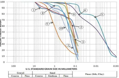
Texturally the soils of Baldia, Orangi and New Karachi Towns as compared to adjacent Towns of SITE, North Nazimabad, Jamshed and Gulshan-e-Iqbal contain higher percentages of fine fractions. The soils of SITE, Nazimabad, Jamshed and Gulshan-e-Iqbal Towns show similar textural characters with fine fractions only at few sites (Fig.s 3a and 3b). The relative percentage of fine fraction continues to be low in the southeastern direction covering the Towns of Lyari, Liaquatabad, Gulberg and Saddar (Fig. 3c).
The towns of Korangi, Landhi and Shah Faisal are developed on either sides of River Malir on alluvial plains and dissected plateau which contribute some fine fractions but not of any significant value (Fig. 3d).
Malir Town shows similar percentages of soil fraction to that of Orangi (Fig. 3e). Most probably this irregular distribution of foundation material in Jamshed and Malir Towns are due to their existence on anticlinorium and synclinorium structural controls in the subsurface. Irregular distribution of percentage of fines on right half bank of River Malir is most probably due to its geomorphological features.
The absence of clay fraction in the sediments of DHA is most probably due to its coastal geographical control and dominance of aeoline deposits from the beach (Fig. 3f).
Bulk Density
The bulk density was determined on the basis of observed soil classes which do vary from town to town and presented graphically in average values (Fig. 4). A comparative review of average bulk density values in the adjacent Towns of Baldia, Orangi and New Karachi indicates the lowest values in New Karachi (1.98-2.10 gm/cm3), most probably due to the fact that its geographical location is at relatively higher elevation of the pediment where the creep of soil is relatively more active than in Orangi and Baldia Towns (1.96-2.14 gm/cm3).
The Towns of SITE, North Nazimabad, Jamshed and Gulshan-e-Iqbal show similar values of bulk densities without any significant change (1.88-2.10 gm/cm3). The similarities in bulk density values can be attributed due to lower clayey fractions in the soils. The similarities in soil characteristics of the towns are mostly an indication of down slope movement of soil from North Nazimabad to SITE Town in South west direction on the left side of River Lyari.
The Towns of Lyari and Saddar likewise Gulberg and Liaquatabad show their geographical sites on the right and left banks of River Lyari respectively with a down slope towards south. The bulk density of the foundation materials of these towns show similar values (1.85–1.99 gm/cm3) most probably due to their geographical locations and the creep in soils which have similar degrees of impacts of human activities on either sides of River Lyari.
The Towns of Shah-Faisal, Landhi and Korangi show similar values of bulk densities without any significant change (1.87-1.97 gm/cm3). This could most probably be because of the presence of fine fraction only in two samples which were collected not far from the river channel sites and can be attributed to River Malir flow activities from time to time.
The Town of Malir situated on the right bank of River Malir shows variable percentages of fine fractions in the soil components and the bulk density values in the range of 1.83-1.95 gm/cm3. Some degree of similarities appears in the bulk density values of DHA samples and Malir Town in spite of the fact that finer fractions in Malir samples are significantly higher whereas in D.H.A. it is in negligible percentages.
Gulraiz Hamid et al. /Int. j. econ. environ. geol. Vol:5(1) 41-46, 2014
3a: Baldia, Orangi and New Karachi Town. 3d: Korangi, Landhi and Shah Faisal Town.
3b: SITE, North Nazimabad, Jamshed and 3e: Malir Town.
Gulshan-e-Iqbal Towns.
3c: Lyari, Liaquatabad,Gulberg and Saddar Town. 3f: D.H.A.
Fig. 3 Graphs showing similar pattern of distribution of sediments in different towns of study area.
Bearing Capacity
The comparative average values of bearing capacity of foundation materials of towns under study were presented graphically (Fig. 5). As the fine fractions are higher in soil samples collected from the Towns of Baldia, Orangi, New Karachi and to some extent in Malir Town, the average bearing capacity values are lesser (218.62-268.75 Kpa) as compared to other towns in which coarse grained sediments are dominated in soils. The greater value of 268.75 Kpa in New Karachi may attribute due to one poorly graded gravel sample-
with a value of 515.23 Kpa and is considered exception so far as the bearing capacity is concerned.
The towns of North Nazimabad and Jamshed contains lesser amount of fine fractions in soil and show relatively higher average values of bearing capacity (303.56 Kpa and 300.78 Kpa) than the towns of SITE and Gulshan-e-Iqbal which contain larger fractions of fine particles and lesser average bearing capacity values (270.14 Kpa and 252.04 Kpa).
Gulraiz Hamid et al. /Int. j. econ. environ. geol. Vol:5(1) 41-46, 2014
In the Towns of Lyari, Liaquatabad, Gulberg and Saddar, the average bearing capacity values were noted in the range of 257.61 – 332.81 Kpa. In these towns clayey fractions were negligible and the soils are classified as well graded sand with silt and in some samples it was noted to be poorly graded sand with silt.
The soils of Korangi, Landhi and Shah Faisal Towns show a range of textural characteristics from well graded to poorly graded sand with silt and have relatively better values of average bearing capacity in Landhi Town (335.59 Kpa) as compared to Korangi (250.78 Kpa) and Shah Faisal Towns (245.08 Kpa). Most probably it is so due to variable percentages of silt and clayey fractions in the soils of these towns.
The soils of Malir Town exhibited average bearing capacity value of 217.71 Kpa as compared to D.H.A. which showed higher average value of 233.94 Kpa. It appears that the lesser values of bearing capacity in Malir Town are because of the clay fractions which were not found in D.H.A. soils.
Conclusion
1. The description of textural characteristics, bulk density and bearing capacity investigated in detail would be of great assistance in critical review of the foundation material of the towns for various civil construction projects to be completed in future.
2. The textural characteristics of the soil samples from different towns of Karachi appear to be related to the existing structural and geomorphological controls exposed on the surface.
3. Manghopir anticline and its extension upto Cape Monze appears to show significant role on the development of geomorphic features like pediment and peripediment zones.
4. The variable percentages of fine fraction in the foundation materials, especially on the downslope of geomorphic features are due to creeping process.
5. According to the classification adopted for the present work, the foundation materials are mostly well graded sand with silt, however at some sites poorly graded foundation materials were also noted, which can be used after necessary modification in structural designs.
6. Generally, the fine fraction in the foundation materials of Baldia, Orangi, New Karachi and Malir Towns were noted to be higher, where pediment and peripediment are well developed and civil construction of medium size are being developed.
7. Most of the towns like Lyari, Liaquatabad, Gulberg, Saddar, North Nazimabad, Jamshed,
Gulshan-e-Iqbal, Korangi, Landhi, Shah Faisal and D.H.A. show very little percentages of fine fraction in the foundation materials and are considered good as foundation material for construction of huge civil structures.
8. The average values of bulk density and bearing capacity determined show sympathetic relationship with the textural characteristics of the foundation materials investigated with few exceptions.
9. The average bearing capacity of the foundation materials was noted to be minimum in the towns of Orangi and Malir. The highest value of bearing capacity was observed in the towns of Lyari and Landhi.
10. Due to present poor demographic management with respect to leakage of sewage effluent drainage system and water supply lines, the foundation materials are in interaction process and continuously affecting the bulk density and ultimately the bearing capacity of the foundation materials. This problem is to be taken on priority basis for safe urbanization in future.
Acknowledgements
I wish to express my sincere gratitude to the Chairman Department of Geology University of Karachi for extending field and laboratory facilities during the work from time to time. We also wish to thank our engineering geology laboratory technician Muhammad Shehzad for technical support during laboratory investigation.
References
Bowles, E. J. (1992). Engineering Properties of Soils and their Measurement, 4th Edition, Irwin, McGraw Hill, New York.
Carter, M.; Bentley, S. P. (1991). Correlation of Soil Properties. Pentech Press, London. Das, M. B.; (2008). Introduction to geotechnical
engineering. Thomson 20-42, 191-198. Hassan, S. A.; Anisuddin, S. (1979). Geology of
Karachi and surrounding areas, Divisional Report (3). Geological Survey of Pakistan, Quetta, Pakistan.
Pithawala, M. B.; Marten-Kaye, P. (1946). Geology and geography of Karachi and its neighborhood. Part-1 Geology, 1-46.
Quraishi, I. H.; Shah, S. A. A.; Tariq, M. A.; Khan, M. S.; Ahsan, S. N.; Akhtar, M. J.; Pasha, M. A.; Khan, I. A.; Khanzada, M. I. (2001). Geological map of Karachi area, Sindh, Pakistan. Geological Survey of Pakistan, Quetta.
Zaidi, S. M. S.; Muhammad, M. J. (1989). Geomorphic Zones and Land Complexes of
Karachi Embayment Area. Karachi University Journal of Science; 17, 35-45.
46