EVALUATION OF DIFFERENT TECHNIQUES FOR GENERATING LANDSLIDE SUSCEPTIBILITY MAP
JAVAD MIRNAZARI
A thesis submitted in fulfilment of the requirements for the award of the degree of
Doctor of Philosophy (Remote Sensing)
Faculty of Geoinformation and Real Estate Universiti Teknologi Malaysia
iii
iv
ACKNOWLEDGMENT
v
ABSTRACT
vi
ABSTRAK
Tanah runtuh merupakan fenomena semulajadi yang kompleks yang menyebabkan kerosakan harta benda dan kehilangan nyawa di serata dunia. Sebagai contoh, di Iran, kebanyakan kejadian tanah runtuh adalah tanah runtuh cetek, berlaku terutamanya di sekitar bahagian barat dan utara negara ini. Khususnya, daerah pendalaman Cheshme Kabud yang terletak di bahagian barat Iran adalah kawasan yang banyak berlaku tanah runtuh akibat dari faktor-faktor sedia ada dan yang mencetuskannya. Dari itu, kajian ini bertujuan menilai ketepatan kaedah-kaedah yang berbeza dalam penghasilan peta-peta kecenderungan tanah runtuh. Tujuan lain kajian ini adalah untuk meramal perluasan tanah runtuh pada masa hadapan terhadap tanah runtuh sedia ada. Kaedah-kaedah yang telah digunapakai dalam kajian ini bagi menentukan kecenderungan terhadap tanah runtuh adalah Penyederhanaan, jaringan neural buatan (ANN), regresi (logistik, spatial dan regresi wajaran geografi (GWR)). Untuk meramal perluasan tanah runtuh sedia ada, kaedah yang telah digunakan adalah regresi julat-altitud wajaran geografi (GAWR). Dalam kajian ini, imej-imej satelit GeoEye-1 and IKONOS telah digunakan bagi menyediakan inventori tanah runtuh. Sembilan faktor pensuasanaan tanah runtuh seperti cerun, aspek, gunatanah, lithologi, jenis tanah, hakisan, jarak kejalan, jarak kesungai dan jarak kegelinciran telah diambil kira dalam analisis. Dalam kaedah Penyederhanaan, semua kelas-kelas bagi faktor-faktor diberi pemberat. Dengan cara ini, kelas-kelas akhir dengan pemberat telah menghasilkan peta kecenderungan tanah runtuh bagi daerah pendalaman Cheshme Kabud. Kekurangan stesen kajicuaca di kawasan kajian menyebabkan kekurangan yang ketara dalam pengumpulan data, mempertimbangkan kesan oleh hujan terhadap pemetaan kecenderungan tanah runtuh dalam kawasan kajian bagi semua kaedah. Dengan membuat penentusahkan terhadap ketiga-tiga kaedah, menggunakan teknik penerima operasi ciri (ROC), keputusan kaedah Penyederhanaan menunjukkan prestasi terbaik dengan ketepatan ramalan 95%. Hasil keputusan dari kaedah GAWR menunjukkan secara umumnya tanah runtuh bersaiz kecil akan mengalami perluasan tanah runtuh lebih banyak dari tanah runtuh bersaiz besar pada masa hadapan.
vii
TABLE OF CONTENTS
CHAPTER TITLE PAGE
DECLARATION ii
DEDICATION iii
ACKNOWLEDGMENT iv
ABSTRACT v
ABSTRAK vi
TABLE OF CONTENTS vii
LIST OF TABLES xi
LIST OF FIGURES xiii
LIST OF ABBREVIATIONS xvii
LIST OF NOMENCLATURES xix
LIST OF APENDICES xx
1 INTRODUCTION 1
1.1 Background of the Study 1
1.2 Problem Statement 4
1.3 Aim of Study 10
1.4 Objective of Study 10
1.5 Research Questions 10
1.6 Scope of Study 11
1.7 Significance of Study 12
1.8 Subject of the Study 13
1.9 Study Area 14
viii
2 LITERATURE REVIEW 16
2.1 Introduction 16
2.2 Landslide Inventories Maps 16
2.2.1 Definition 16
2.2.2 Assumptions to Produce Landslide Inventory Map
17
2.2.3 Description of Landslide Inventory Map 19
2.2.4 Scale of Map 20
2.2.5 Type of Landslide 21
2.2.6 Quality of Landslide Inventory Map 22 2.3 Conventional Methods for Landslide Inventories Maps 24
2.3.1 Geomorphology Method 24
2.3.2 Interpretation of Aerial Photograph (Visualization) 25 2.4 New Methods for Preparing Landslide Inventory Maps 27 2.5 Analysis and Interpretation of Satellite Imagery 28
2.6 Landslide Susceptibility Maps 31
2.6.1 Main Cause of Landslide 31
2.6.2 Input Data and Essential Information 33 2.6.3 Data Management: Collection, Storage and
Selection
35
2.6.4 Data Reliability and Accuracy 36 2.6.5 Scheme of Various Techniques to Assess of
Landslide
37
2.6.6 The Past and Present are Keys to the Future 42 2.6.7 Rate of Hazard can be Assessed 43
2.6.8 Qualitative Methodologies 43
2.6.8.1 Field Geomorphological Analysis 44 2.6.8.2 Combination or Overlay of Parameter
Maps
46
2.6.9 Quantitative Methodologies 51
2.7 Produce of a Landslide Map 57
2.7.1 Geotechnical Methods 58
2.7.1.1 Deterministic Method 58
2.7.1.2 Safety Factor as a Basis for Hazard 59 2.7.1.3 Probabilistic Procedure 61
ix
2.9 Logistic Regression Method 75
2.10 Moderation Method 87
2.11 Chapter Summary 91
3 METHODOLOGY 95
3.1 Introduction 95
3.2 Study Research 98
3.3 Research Materials 101
3.4 Research Procedure 120
3.4.1 Moderation Method 120
3.4.2 Statistical Methods 126
3.4.2.1 Regression Method 127
3.4.3 Artificial Neural Network 139
3.4.3.1 Application for Determination Factors 144
3.4.3.2 Sensitivity Analysis 146
3.4.3.3 Sensitivity Score 147
3.4.4 Validation of Methods 148
4 RESULTS AND DISCUSIONS 150
4.1 Introduction 150
4.2 Moderation Method Map Results 151
4.2.1 Soil Moderation Mode 157
4.2.2 Distance to River Moderation Model 159
4.2.3 Lithology Moderation Model 160
4.2.4 Distance to Road Moderation Model 162
4.2.5 Erosion Moderation Model 165
4.2.6 Landuse Moderation Model 166
4.2.7 Aspect Moderation Model 169
4.2.8 Distance to Fault Moderation Model 170
4.2.9 Slope Moderation Model 173
4.3 Regressions LR, SR and GWR 179
4.4 Artificial Neural network (ANN) 195
x
4.5.1 Moderation Models 205
4.5.2 Comparison of Performances of SR and LR 207
4.5.3 GWR Method 210
4.5.4 Sensitivity Analysis of the ANN 211 4.5.5 Comparison Result of GWR and ANN, Moderation 214
5 CONCLUSION AND RECOMENDATIONS 217
5.1 Introduction 217
5.2 Conclusion 218
5.3 Recommendations 220
REFERENCES 222
xi
LIST OF TABLES
TABLES NO. TITLE PAGE
2.1 Coefficient of Logistic Regression between factors for
landslide susceptibility map 84
3.1 Scheme of the receive operation curve used to construct
the formula 149
4.1 Determination weight classes of the influencing factors
in the Gray system 152
4.2 Multicollinearity Test Result for Cheshme Kabud rural
district data 154
4.3 Comparison R square predicting factors before and after
enter the models 154
4.4 Logistic coefficient changes after enter Moderation
variable in the models 155
4.5 Detail of Moderation result between parameters 155 4.6 Nagelkerke changing between parameters after enter in
moderation method 176
4.7 Cox-Snell criteria with and without parameters enter In
Moderation method 176
4.8 Comparison between direct effect and after soil
Moderation model was applied 177
4.9 Area and percent of susceptibility in each type of
Moderation model classes 177
4.10 Represents relationship between area susceptibility
classes and landslide occurrence 178
4.11 Frequency ration between each susceptibility Moderation
models classes 179
4.12 The number of landslide in the low and high
susceptibility area in percent 179
4.13 Frequency (Relative Landslide Density) of landslide in
xii
4.14 Comparison values of the GWR, LR and SR methods of
the study area 187
4.15 The comparison of the area extent based on the regression coefficients using the global and local
methods 188
4.16 Comparison of percentage of landslide occurrences in
susceptibility different classes by LR and SR methods 192 4.17 Weights of each neuron related to factor in ANN 197 4.18 Result of ANN prediction for the produced landslide
susceptibility by Neuraltools6.2 199
4.19 Summary of the training and testing of ANN method
using Neuraltools6.2 software (Trial version) 202 4.20 Comparison result of root mean squared error (RMSE) in
linear and ANN methods 203
4.21 Parameter final before and after applying Moderation
models 208
4.22 Summary statistics for GWR parameter estimates 212 4.23 Results of sensitivity analysis of the ANN method with
xiii
LIST OF FIGURES
FIGURE NO. TITLE PAGE
1.1 Land use affected by landslide occurrence 5 1.2 Deforestation and changing land use in study area lead to
landslide occurrence 6
1.3 Changing land use from range to cultivated land has cause
landslide 6
1.4 Large landslide occurred, the consequence of cut of the
slope toe by river 7
1.5 Removal of slope toe and occurrence of landslide 7
1.6 Debris flow in Cheshme Kabud 8
2.1 Rotational landslide 21
2.2 Transitional landslide 22
2.3 Classification of landslide hazard assessment approaches 40 2.4 Schematic representation of the method proposed by
Amadesi and Vianello 49
2.5 Schematic a logical analytical model 50
2.6 Process of preparing slope failure (susceptibility) map 54 2.7 Summary of deterministic methods for susceptibility and
hazard assessment 61
2.8 Synthetic representation of the semi-quantitative approach
proposed 63
2.9 Combination of neural and fuzzy procedure for landslide susceptibility mapping in Darjeeling Himalayas 69 2.10 Back-propagation artificial neural network architecture
constructed in study 72
2.11 ROC curve for the logistic regression method. The area
under the ROC curve (AUC) is 0.83 82
xiv
2.13 Conceptual diagrams for the Moderator models 89
3.1 Outline of the study methodology 97
3.2 Research area in the Iran (a) and Kermanshah province (b) 99 3.3 Southeast part of the study area on Google Earth 100 3.4 Landslide inventory on GeoEye satellite image 103 3.5 The original scale lithology map with 1:100,000 scale,
comprising of 3 different main rock types overlaid with
landslide locations 106
3.6 The seismic zones on the Richter scale, overlaid with
landslide locations 107
3.7 Erosion map of study area 108
3.8 Soil map of the study area 109
3.9 Distance of landslides locations to rivers in the Cheshme
Kabud area 111
3.10 Map shows distance of landslides locations to road
(buffering) in the study area 112
3.11 Landuse map of Cheshme Kabud 113
3.12 Landuse map of Cheshme Kabud on Google Earth (a=
whole area, b= Eastern part of the area) 114 3.13 DEM (10 meter) of Cheshme Kabud rural district 115 3.14 Relationships between altitudinal classes and landslide
distribution points in the study area 116
3.15 Slope map of Cheshme Kabud 117
3.16 Aspect map of the study area 118
3.17 NDWI map extracted from Aster image 119
3.18 Process of generating of Soil Moderation (one of the 9
models) model in SPSS and ArcGIS software. 125 3.19 Flowchart shows stages of the preparation for
susceptibility mapping using Moderation method 126 3.20 A spatial example of Simpson’s Paradox. Horizontal axis
is population density and vertical axis is house price 132 3.21 GWR with fixed (a) and adaptive (b) spatial kernels 134 3.22 Optimum bandwidth for using GAWR method (CVRSS=
Cross-validated sum of squared errors). 138 3.23 Optimum vertical exaggeration (meter) for calculation
GAWR 138
3.24 Using the neural network structure to produce landslide
xv
3.25 ANN diagram in Matlab software 141
4.1 Parameters influencing weights in the Gray system 152 4.2 Cumulative Frequency of Soil Moderation model 157 4.3 Landslide susceptibility map produced by Soil
Moderation model 158
4.4 Cumulative Frequency of River Moderation model 159 4.5 Landslide susceptibility map prepared by River
Moderation model 160
4.6 Cumulative Frequency of Lithology Moderation model 161 4.7 Landslide susceptibility map extracted by Lithology
Moderation model 162
4.8 Cumulative Frequency of Road Moderation model 163 4.9 Landslide susceptibility map extracted by Road
Moderation model 164
4.10 Cumulative Frequency of Erosion Moderation model 165 4.11 Landslide susceptibility map produce by Erosion
Moderation model 166
4.12 Cumulative Frequency of Landuse Moderation model 167 4.13 Landslide susceptibility map extracted by Landuse
Moderation model 168
4.14 Cumulative Frequency of Aspect Moderation model 169 4.15 Landslide susceptibility map produce by Aspect
Moderation model 170
4.16 Cumulative Frequency of Fault Moderation model 171 4.17 Landslide susceptibility map extracted by Fault
Moderation mod 172
4.18 Cumulative Frequency of Slope Moderation model 173 4.19 Landslide susceptibility map exracted by Slope
Moderation model 174
4.20 Residual GWR method of study area 180
4.21 Local R-squared values map in the study area 181 4.22 The spatial variation of Radiolarite coefficient values
from GWR calculation 183
4.23 Comparison of LR and GWR for the coefficient of
lithology parameter 185
xvi
4.25 Susceptibility map created from the LR method showing the None, Low, Moderate, High and Very- High
susceptibility classes 188
4.26 Cumulative Frequency landslide of Logistic Regression method
189
4.27 Susceptibility map generated from the SR method represented the None, Low, Moderate, High and
Very- High susceptibility classes 190
4.28 Cumulative Frequency landslide of Spatial Regression
method 191
4.29 Landslide area prediction by GAWR method 193 4.30 Prediction of landslide area extend in Southwest of
Cheshme Kabud 194
4.31 Bar graph shows estimates changing in landslide existing area (blue color) to prediction landslide area (red color) by
GAWR method for 85 landslides 195
4.32 Illustration of Cumulative Frequency landslide of ANN
method 203
4.33 Landslide susceptibility map produced by ANN method 204 4.34 Result of R2 for training, testing and validation dataset by
ANN method by Matlab software 205
4.35 Comparison of the LR (a) and SR (b) methods by using
ROC curve 209
4.36 Histogram shows residuals of GWR using SAM method 211 4.37 Result of the sensitivity analysis of the ANN method 214 4.38 ROC results of three methods ANN, GWR and
xvii
LIST OF ABBREVIATIONS
AI Artificial Intelligent ANN Artificial Neural Network
AUC Area Under Curve
CAR Conditional Auto Regressive
DEM Digital Elevation Model
DTM Digital Terrain Model
ENVI Environment for Visualizing Images ERDAS Earth Resources Data Analysis System ETM+ Enhanced Thematic Mapper Plus
GAWR Geographically Altitudinal Weighted Regression
GCP Ground Control Points
GIS Geographic Information System
GPS Global Position System
GSD Ground Sampling Distance
GWR Geographically Weighted Regression
IRS Indian Remote Sensing
ISODATA Iterative Self-Organizing DATA
LHZ Landslide Hazard Zonation
LiDAR Light Detection and Ranging
LR Logistic Regression
LRA Landslide Risk Assessment
LRA Logistic Regression Analysis LSZ Landslide Susceptibility Zonation
MLP Multi-Layer Perceptron
MLP Multilayered Perceptron
xviii
NDWI Normalized Difference Water Index NDWI Normalized Difference Water Index
OBIA Object Image Analysis
PNN Probabilistic Neural Network
RMSE Root Mean Square Error
ROC Receiver Operating Characteristic RPC Rationale Polynomial Coefficients RRN Relative Radiometric Normalization
SA Sensitivity Analysis
SAR Simultaneous Auto Regression SAR Synthetic Aperture Radar SAS Statistical Analysis System
SMA Spatial Moving Average
SPOT System Pour l’Observation de la Terre SPSS Statistical Package for the Social Sciences
SR Spatial Regression
SR Sensitivity Ratio
SSPC Slope Stability Probability Classification
U.S. EPA United States Environmental Protection Agency
UCU Unique Condition Unit
xix
LIST OF NOMENCLATURES
R2 - coefficient of the determination of a regression p - property of an even occurring
β0 - the intercept of the model
ε - vector of errors with zero mean and constant variance σ2
w - proximity matrix
ρ - interaction parameter or spatial autoregressive coefficient
y - vector of observations on the dependent variable
β - parameter to be estimated due to relationship between the variables
Y - landslide occurrence
- the vector of estimated parameters
X - the matrix of independent variables
xx
LIST OF APPENDICES
APPENDIX TITLE PAGE
A Sample questionnaire 251
B Detail Result of GWR by GWR.4 software 255
C Some parts of GWR results in ARCGIS 10 software 280 D GAWR results in Microsoft Excel software (only
small part)
282
1
CHAPTER 1
INTRODUCTION
1.1 Background of the Study
A landslide is defined as "the movement of a mass of rock, debris, or soil down a slope" (Cruden, 1992). Failure of a slope occurs when the force that is pulling the slope downward (gravity) exceeds the strength of the earth materials that compose the slope. It can occur in the anywhere in the entire world except for extremely arid areas, land frozen permanently and all regions with less than a 5-degree slope angle (Muthu and Petrou, 2007).
Landslides are the world’s third largest natural disaster that causes a lot of damage (Zillman, 2000). On the world scale, landslides cause billions of dollars in loss and thousands of deaths and injuries each year. Some countries suffer more damage; they lose about 0.5% of their gross national product per annum due to landslides (Chung, 1995). A landslide, which is a single slope slide, is mostly not as remarkable or costly as earthquakes, main floods, storms, or some other natural hazards. However, they are extremely widespread, and over the years may cause more things to be lost than any other geologic hazard. Besides, much of the destruction and sometimes a considerable proportion of the loss of life occurring with earthquakes and extreme storms are due to landslides (Varnes, 1984).
2
was buried under thousands of tons of soil and all of people living in the village were dead. They could not even be dug out from under the soil for their funeral. Iran is mostly of a mountainous topography with tectonic activity, and is highly seismic with a sensitive geology and climatic conditions that are extremely susceptible for landslide occurrence. In most of Iran, landslides are a common disaster. Based on preliminary government estimation (2005) of the financial loss caused by landslides is about $126 billion. This was in addition to the loss of life, and injuries that occurred. Many landslides have occurred in Iran, of which the number of casualty was estimated to be about 32,000 lives (Government report, 2012).
Most of the landslide occurrences in Iran are shallow; but, tectonic landslides can also be seen in the zone of geology, which matches on the fault lineation. In areas near to the author’s study area, (about 50 km distance) in the mid of April 2002, an earthquake triggered some landslides and rock falls which destroyed rural buildings, agriculture and grasslands. Nevertheless, in the author’s study area, no landslides could be found that occurred due to the direct effect of the earthquake.
Landslides require proper planning for proper management and control. In landslide management, landslide detection is the first important step. The detection of landslide requires suitable knowledge about the current and future landslide occurrences. Landslide inventory records landslide occurrences using various methods. However, the exact date of occurrence of a landslide is difficult to ascertain. Notwithstanding, if the landslide is new, the date of occurrence can be estimated, even though it is difficult to determine the exact time of occurrence.
3
al., 2009; Mathew et al., 2007; Pradhan et al., 2010; Cervi et al., 2010; Regime et
al., 2010; Mezughi et al., 2011).
Other works such as (Anbalagan., 1992; Anbalagan et al., 1996; Süzen et al., 2004; Chau et al., 2004; Kanungo et al., 2006; Gupta et al., 2008; Chauhan et al., 2010; Singh et al., 2011) also predicted landslide spatially using such methods as landslide hazard zonation (LHZ) and landslide susceptibility zonation (LSZ) maps. In landslide zonation and inventory mapping, various algorithms and tools are utilized. These methods include both direct and indirect techniques which can be divided into statistics, heuristic (geomorphologic, physical (unit)), seasonal, event and data mining (neural network and fuzzy logic) (Domínguez-Cuesta et al., 2007; Nefeslioglu et al., 2008; Sato et al., 2009; Listo et al., 2012; Havenith et al., 2006).
“Direct” means that the researcher requires doing more investigations in the
fieldwork for landslides. Most of the landslide’s identification and estimations are undertaken straight on the ground. The researcher needs to find some indicators from the field, such as a failure of rock and soil, water drainage types and other evidences of factors that can cause the acceleration of landslide occurrence. Indirect methods include the use of satellite images, aerial photographs, and base maps like topographic maps and lithology, which give aid to identify landslides and determine landslides (Van Westen et al., 2003; Yalcin, 2007; Bednarik et al., 2010; and Van Westen et al., 2008).
Researchers use devices and tools to accelerate and provide more accuracy in producing inventories and susceptibilities maps. These devices comprise Global Position System (GPS), satellite images, aerial photos and GIS software which have been used with regards to their access and are compatible with a condition of the environment (Kanungo et al., 2006; Herrera et al., 2009; Kaunda., 2010; Nichol et al., 2009; Gupta et al., 2008; and Alkevli et al., 2010, 2013). The algorithm is
4
al., 1994; Van Westen et al., 1993; Pachauri et al., 1992; Nilsen, 1979; Brab, 1972;
Radbruch et al., 1982; and Anbalagan, 1992).
Algorithms are chosen in accordance with the achievement of the desired goals and objectives of the research. In summary, methods are a bridge between devices and algorithms. For landslide susceptibility, the use of practical and accurate algorithms is indeed vital. These algorithms are usually named after their inventors (Miles et al., 1999; Gupta et al., 1997). Sometimes, devices and methods are also considered as algorithms (Melchiorre et al.,2008; Saito et al.,2009; Pavel et al.,2008; Borgogno et al.,2009; Frattini et al.,2010; Yeon et al.,2010; Pradhan et al.,2010). In the current study, to best of author knowledge, a method called Moderation is proposed for the first time in the study of landslide susceptibility. The current study also employs methods such as the logistic and spatial regressions, Geographically Weighted Regression (GWR), Geographically Altitudinal Weighted regression (GAWR) and Artificial Neural Network (ANN) methods with some data acquired from devices satellite images and aerial photographs.
1.2 Problem Statement
Landslide is severe environmental hazards in mountainous areas (Zinck et al., 2001). This natural phenomenon constitutes a major destructive natural event striking civilian urban settlements and infrastructures, resulting to serious damages among humans the world over (Peyret et al., 2008); and constitutes a major cause of disaster in western Iran. Among the areas particularly prone to landslides are the sloppy areas, regions of heavy rain as well as poor vegetation.
5
Cultivation lands (agriculture lands) are more susceptible to landslide occurrence compared to rangelands or grasslands due to plowing (Figure 1.1 and 1.2). Cultivation specifically reduces the strength of the regolith, thereby making the slopes to be more susceptible to landslides. This is due to the fact that cultivated lands are covered by plants only during specific periods of the year (cultivation periods), while grasslands are usually covered across the entire year. Within the study area, some of the rangelands or pastures comprise of shrubs and scattered trees, both of which significantly contribute to the process of evapotranspiration and decrease soil water-holding capacity.
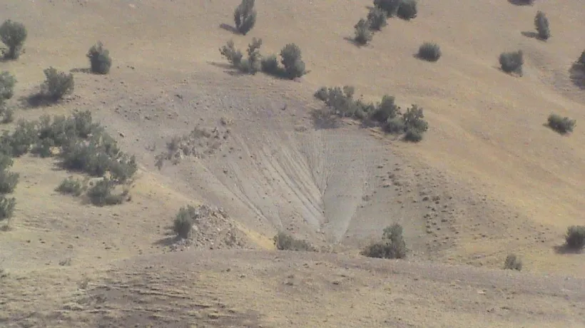
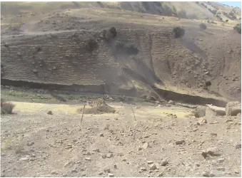
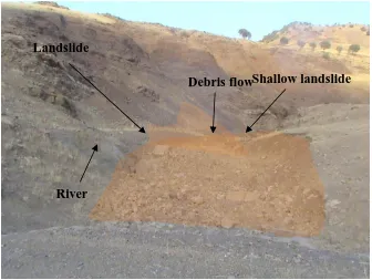
These trees, which also have high water consumption capacity and drainage, result in keeping the soil light. The tree roots, shrubs and small plants, especially root surfaces, help soil particles to bond together, thereby preventing the soil from slipping. Changes in land use from pasture and forest to cultivated lands may cause increasing landslide occurrences (Figure 1.3). In some parts of the study area, shallow and large landslides had occurred due to cutting of slope toes by running rivers (Figures 1.4 and 1.5), resulting in the generation of large quantities sediment and debris flows (See Figure 1.6).
6
Figure 1.2 Deforestation and changing land use in study area lead to landslide occurrence
Figure 1.3 Changing land use from range to cultivated land has cause landslide
7
Figure 1.4 Large landslide occurred, the consequence of cut of the slope toe by river
8
Figure 1.6 Debris flow in Cheshme Kabud
It has an average elevation of 1500 m above sea level. Instability of the area, damaged roads and natural resources were found in the study area. Deforestation due to human activities contributes to landslide occurrences. There are villages and farms that are located on unstable terrain; therefore, there is a need for the ability to help the people avoid danger by assisting them in the resettlement to a new place away from the hazardous region.
Numerous research works have been done on landslide susceptibility mapping for the last several decades (Guzzetti et al., 1999; Fourniadis et al., 2007; Kawabata et al., 2009; Pradhan., 2010) together with the proposal of various methods and algorithms for landslide susceptibility mapping. While the choice and scale of a landslide map depends on many factors, a primarily determinant of the choice of map is the requirements of the end user as well as the ultimate purpose of the investigation (Varnes, 1984). In the recent years, methods of landslide susceptibility mapping were shifted from physical to statistical and data mining with the help of GIS and remote sensing techniques.
Shallow landslide Debris flow
Landslide
9
Landslide susceptibility can be divided into two categories: qualitative and quantitative or direct and indirect. Qualitative methods are subjective and portray the hazard level in descriptive terms. Geomorphology mapping is an example of a qualitative and direct method. Quantitative methods produce numerical estimates (probabilities) of the occurrence of landslide phenomena in any susceptibility zone. Direct landslide susceptibility mapping involves mapping landslides within a given region by means of field studies, aerial photography interpretation or other methods (Yesilnacar, 2005).
Methods of qualities and quantities require the use of algorithms, which make them suitable for predicting precisely in most environments around the world. Algorithm may rely on specific assumptions that are compatible with real life conditions. For example, landslide never occurs in any slope less than 5 degree or 8 percent because of the weak gravity (solifluction and mudflow or other flows are not considered as landslides). However, many landslide susceptibility maps ignore this point, and as such, are unable to show surfaces that are sensitive to exact locations of landslide occurrence.
In spite of frequent landslide occurrences in the study area, this region does not have the landslide inventory and susceptibility maps. The most worrying of the landslides in the study area is that they have occurred near to villages. This problem is a high risk problem, especially in the South East of the area where numerous villages are located in a linear form are prone to landslide and flood hazards. Exact inventories that map the determine locations of past landslides in the region will give knowledge about sites and places of these landslides, which will give aid to understanding future events (Guzzetti et al., 2012). A landslide inventory will help researchers to select more and precise parameters that will most probably affect landslide occurrences (Korup, 2004). Therefore, if one can identify landslides, it can help to control, mitigate or prevent the landslide hazards.
10
together with two other methods: several regression methods and neural network. Then, the author compared the results with existing landslides. Before that, a landslide inventory was produced using high-resolution satellite images (Ikonos, GeoEye), aerial photography (1:20,000), GPS and fieldwork.
1.3 Aim of Study
To evaluate the accuracy of different methods of landslide susceptibility.
1.4 Objective of Study
i. To determine the best Moderation model of predicting landslide occurrence based on existing landslides.
ii. To compare the accuracy of Moderation, regressions and Neural Network methods for landslide susceptibility.
iii. To investigate the capability of Geographically Altitudinal Weighted Regression (GAWR) method for predicting the area extends of existing landslides in the future.
1.5 Research Question
1- What is the best Moderation model to predict landslide occurrence?
2- Which one of the three methods: Moderation, regressions and Neural
11
1.6 Scope of Research
In this study, methods and devices for mapping single landslides, or clusters of slope failures have not been considered since the priority has been on a regional scale. Generally, for the single landslide study, it always involves monitoring or a geotechnical survey. The methods and techniques used in this research were for mapping the surface characteristics of shallow landslides (soil slide). Other slides and topples including mud fall; rock fall and flow were not considered in this study even for susceptibility mapping.
This research has been to assess and estimate places that are susceptible to landslide. Therefore suitable tools, methods and algorithms were necessary. Images of GeoEye and Ikonos had a coverage of about 85% of the region and were used in this research. Although, there are not a large number of landslides in the remaining of the study area (15 percent), but the remaining area was investigated by fieldwork; also, by using Cartosat 1 images (pan 2.5 resolutions).
Nine parameters were used to produce landslide susceptibility including lithology, Land use, soil, proximity to river, road, and fault, aspect, erosion and slope. Although rain is particularly influential to landslide occurrence, in this study, it was ignored because there were no weather stations in this area.
12
1.7 Significance of Study
Landslide susceptibility mapping is one of the important strategies for landslide management. The landslide susceptible maps provide essential knowledge of landslide susceptibility situation of a certain region, which is useful for the community in planning, mitigating and avoiding the danger of landslides. On the other hand, landslide susceptibility maps of a specific site are prepared not only for landslide monitoring but also for delineating areas requiring mitigation measures.
The study area does not have any landslide map and other hazard maps, therefore, the production of landslide inventory and susceptibility maps will serve as important aids for decision makers and the government in the monitoring and control of present and future landslides. In addition, some parts of the study area face problems associated with sediment drive from landslides, which have negative effects, such as direction shift, on the main river in the region.
One of the significant impacts of landslides is the destruction of grassland areas for pasture. These grasslands are critically used by nomadic farmers and villagers for their cattle and livestock. Landslide susceptibility shows the situation of this type of phenomena as well as the associated hazard, which aid the government in the drive towards sustaining such slopes sensitive to landslides. Landslide susceptibility shows the most susceptible areas to landslide.
13
is a powerful regression technique used for this correlation at the local scale, and also uses account altitudinal coordinates for predicting the extent of the existing landslide area. As such, the GAWR technique is applied in the current study for predicting the area extent of landslide, which can be constant, decreasing or increasing in area with reference to future landslides.
1.8 Subject of the Study
The subject of the study is shallow landslides, which usually comprise of soil, young soil and debris. This type of landslide is usually divided into rotational and transitional forms. Topple, rockfall, creep and earth flow are not investigated in this study because they do not have characteristics or share similar conditions with landslide occurrence. Based on fieldwork, most of the landslides that were observed are close to villages, rivers and roads.
Moreover, landslides have occurred in several parts of the research area where there are land use changes ranging from forest to cultivated and agricultural lands. Hummocky land is more sensitive to shallow landslides than the plain and mountainous parts of the area. This part of the area is located in the South of Cheshme Kabud rural district. There are a numerous of landslides of different ages criterion such as dormant, old and new landslides. Nevertheless, in the recent years, the numbers of new landslides have fallen due to reduced rainfall.
The shallow landslides are different in depth and size, but these attributes are very similar among shallow landslides compared to deep-seated landslides. Some parts of the area (Northern) have been explored for mining. Consequently, it was observed that this human activity created artificial landslides. Therefore, these landslides are negligible and not considered in landslide inventory and susceptibility preparation in this research.
14
Since high-resolution images (Ikonos and GeoEye) are available, the scale of landslide susceptibility produced can be 1:10,000. Nevertheless, this scale is not adequate for slope stability analysis given the fact that even shallow landslides are neighboring to each other. Therefore, a group of landslides rather than a single landslide is considered in this research.
1.9 Study Area
The study area lies between latitude 34° 05' 00''N and 34° 13' 00''N, and longitude 47° 13' 00''E and 47° 22' 00''E, and covers an area of 250 km2. The geology is the study area is limestone. The terrain is characterized by rugged topography, steep rocky slopes at higher elevations, and mountain peaks more than 600 m above the ground. Gentle to moderate slopes at low and mid elevations are typically mantled by deposits that range in texture from clays and silts to coarse gravels.
Slopes are commonly steeper than 25%, with steepness generally increasing with elevation. Bedrock consists primarily of limestone and radiolarite rocks. Climate is generally semi-arid (Mediterranean) characterized by hot dry summers and mild wet winters. However, temperature and precipitation are significantly influenced by elevation. The mean annual air temperature varies from 14.3 °C to 15.9 °C. The average annual precipitation is about 400 mm, with a daily maximum of 53 mm.
1.10 Overview of Thesis
15
Chapter 1 provides the introduction of the study. This chapter includes the background of the study including definitions and types of landslides, the effects of landslides in the study area, regions generally damaged by landslides, methods of susceptibility and assessment of landslides, data and algorithms used for evaluating landslides. The chapter also contains the problem statement, scope, aim and objectives as well as the significance of the current study.
Chapter 2 focuses on the literature review of previous related researches, theories and as well as practical implementations. The review includes the history of the landslide inventory and susceptibility mapping by the various researchers whom used different models and algorithms for the attainment of results.
Chapter 3 provides the description of the study area as well as the research methodology of the current study. This chapter illustrates in detail the regression methods (logistic, spatial, Geographically Weighted Regression and Geographically Altitudinal Weighted Regression), Artificial Neural Network as well as the Moderation methods.
Chapter 4 presents the result and analysis of the current study. This chapter also illustrates the accuracy assessment of the results. In chapter 5, the thesis is concluded, and the recommendations for future work stated.
222
REFERENCES
Abbott, L. and Cook, T. (2004). Hiking the Grand Canyon's geology. The Mountaineers Books.
Abdel-Latif, M. (1994). Landslide hazard assessment. The Ohio State University. Abu-Zeid, N., Furlanis, S., Oddone, E., Bacchini, M., Gaspari, E., Tagliavini, F. and
Zannoni, A. (2003). Debris flow hazard assessment applying the resistivity imaging method: case study of Cancia (Dolomites, northeastern Italy). Proceedings of the Third International Conference on Debris-flow Hazards
Mitigation. Millpress Science Publishers: Rotterdam, 787-798.
Acharya, G., Cochrane, T., Davies, T. and Bowman, E. (2011). Quantifying and modeling post-failure sediment yields from laboratory-scale soil erosion and shallow landslide experiments with silty loess. Geomorphology 129(1): 49-58.
Akgün, A. and Bulut, F. (2007). GIS-based landslide susceptibility for Arsin-Yomra (Trabzon, North Turkey) region. Environmental Geology, 51, 1377-1387. Aksoy, B. and Ercanoglu, M. (2012). Landslide identification and classification by
object-based image analysis and fuzzy logic: An example from the Azdavay region (Kastamonu, Turkey). Computers & Geosciences, 38, 87-98.
Aleotti, P. and Chowdhury, R. (1999). Landslide hazard assessment: summary review and new perspectives. Bulletin of Engineering Geology and the Environment, 58, 21-44.
Alkevli, T. and Ercanoglu, M. (2010). Usage of ASTER Level 3A Data in Landslide Inventory Mapping: Visual Interpretation versus Fieldwork. EGU General Assembly Conference Abstracts, 1305.
223
Alkevli, T. and Ercanoğlu, M. (2013). Usage of ASTER Level 3A Stereo Data in
Landslide Inventory Mapping: Visual Determination Versus Fieldwork. Landslide Science and Practice. Springer. 163-168.
Alkevli, T., Ercanoglu, M., 2011 (2011). Assessment of ASTER satellite images in landslide inventory mapping. Bulletin of Engineering Geology and the Environment.
Amadesi, E. and G. Vianello (1980). Connection between remote sensing and data-bank for the land thematic mapping. International archives of photogrammetry.6-14.
Amanti, M., Carrara, A., Castaldo, G., Colosimo, P., Gisotti, G., Govi, M., Marchionna, G., Nardi, R., Panizza, M. and Pecci, M. (1992). Linee guida per la realizzazione di una cartografia della pericolosità geologica connessa ai fenomeni di instabilità dei versanti alla scala 1: 50.000. Presidenza del Consiglio dei Ministri. Servizio Geologico, Progetto CARG.
Anbalagan, R. (1992). Landslide hazard evaluation and zonation mapping in mountainous terrain. Engineering geology, 32, 269-277.
Anbalagan, R. and Singh, B. (1996). Landslide hazard and risk assessment mapping of mountainous terrains—a case study from Kumaun Himalaya, India. Engineering Geology, 43, 237-246.
Antonini, G., Ardizzone, F., Cardinali, M., Galli, M., Guzzetti, F. and Reichenbach, P. (2002). Surface deposits and landslide inventory map of the area affected by the 1997 Umbria-Marche earthquakes. Bollettino della Società geologica italiana, 121, 843-853.
Ardizzone, F., Cardinali, M., Carrara, A., Guzzetti, F. and Reichenbach, P. (2002). Impact of mapping errors on the reliability of landslide hazard maps.
Ardizzone, F., Cardinali, M., Galli, M., Guzzetti, F. and Reichenbach, P. (2007). Identification and mapping of recent rainfall-induced landslides using elevation data collected by airborne Lidar.
Arora, M., Das Gupta†, A. and Gupta, R. (2004). An artificial neural network
approach for landslide hazard zonation in the Bhagirathi (Ganga) Valley, Himalayas. International Journal of Remote Sensing, 25, 559-572.
224
Atkinson, P. and Massari, R. (1998). Generalised linear modelling of susceptibility to landsliding in the central Apennines, Italy. Computers & Geosciences, 24, 373-385.
Ayalew, L. and Yamagishi, H. (2005). The application of GIS-based logistic regression for landslide susceptibility mapping in the Kakuda-Yahiko Mountains, Central Japan. Geomorphology, 65, 15-31.
Baeza, C. and Corominas, J. (2001). Assessment of shallow landslide susceptibility by means of multivariate statistical techniques. Earth surface processes and landforms, 26, 1251-1263.
Bajracharya, B., Bajracharya, S.R (2008). Landslide mapping of the Everest region using high resolution satellite images and 3D visualization.
Baldelli, P., Aleotti, P. and Polloni, G. (1996). Landslide susceptibility numerical mapping at the Messina Straits crossing site, Italy. Proceedings of the VIth ISL, Trondheim, Norway, 153-158.
Baldi, P., Fabris, M., Marsella, M. and Monticelli, R. (2005). Monitoring the morphological evolution of the Sciara del Fuoco during the 2002–2003 Stromboli eruption using multi-temporal photogrammetry. ISPRS journal of photogrammetry and remote sensing, 59, 199-211.
Barbieri, G. and Cambuli, P. (2009). The weight of evidence statistical method in landslide susceptibility mapping of the Rio Pardu Valley (Sardinia, Italy). Proceedings of 18th World IMACS/MODSIM Congress, Cairns, Australia,
2658-2664.
Barlow, J., Franklin, S. and Martin, Y. (2006). High spatial resolution satellite imagery, DEM derivatives, and image segmentation for the detection of mass wasting processes. Photogrammetric engineering and remote sensing, 72, 687-692.
Baron, R. M. and Kenny, D. A. (1986). The moderator–mediator variable distinction in social psychological research: Conceptual, strategic, and statistical considerations. Journal of personality and social psychology, 51, 1173. Barredo, J., Benavides, A., Hervás, J. and van Westen, C. J. (2000). Comparing
225
Bathurst, J. C., Bovolo, C. I. and Cisneros, F. (2010). Modelling the effect of forest cover on shallow landslides at the river basin scale. Ecological Engineering, 36, 317-327.
Baum, R. L., Schuster, R.L., Godt, J.W (1999). Map showing locations of damaging landslides in Santa Cruz County, California, resulting from 1997 to 98 El Nino rainstorms.
Bednarik, M., Magulová, B., Matys, M. and Marschalko, M. (2010). Landslide susceptibility assessment of the Kraľovany–Liptovský Mikuláš railway case study. Physics and Chemistry of the Earth, Parts A/B/C, 35, 162-171.
Beguería, S. and Lorente, A. (2002). Landslide hazard mapping by multivariate statistics: comparison of methods and case study in the Spanish Pyrenees. Barbieri, G. and P. Cambuli (2009). The weight of evidence statistical method in
landslide susceptibility mapping of the Rio Pardu Valley (Sardinia, Italy). Proceedings of 18th World IMACS/MODSIM Congress, Cairns, Australia. Baron, R. M. and D. A. Kenny (1986). The moderator–mediator variable distinction
in social psychological research: Conceptual, strategic, and statistical considerations. Journal of personality and social psychology 51(6): 1173. Berggren, B., Fallsvik, J. and Viberg, L. (1992). Mapping and evaluation of landslide
risk in Sweden. International symposium on landslides.
Berti, M., et al. (2012). Probabilistic rainfall thresholds for landslide occurrence using a Bayesian approach. Journal of Geophysical Research: Earth Surface (2003–2012) 117(F4).
Bishop, C. M. (1995). Neural networks for pattern recognition. Oxford university press.
Blahut, J., van Westen, C. J. and Sterlacchini, S. (2010). Analysis of landslide inventories for accurate prediction of debris-flow source areas. Geomorphology, 119, 36-51.
Borghuis, A., Chang, K. and Lee, H. (2007). Comparison between automated and manual mapping of typhoon‐triggered landslides from SPOT‐5 imagery.
International Journal of Remote Sensing, 28, 1843-1856.
226
Brabb, E., Colgan, J. P. and Best, T. C. (1999). Map showing inventory and regional susceptibility for Holocene debris flows and related fast-moving landslides in the conterminous United States. MAP MF-2329. USGS.
Brabb, E. E. (1991). The world landslide problem. Episodes, 14, 52-61.
Brabb, E. E. (1995). The San Mateo County California GIS project for predicting the consequences of hazardous geologic processes. Geographical Information Systems in Assessing Natural Hazards, Kluwer Academic Publisher,
Dordrecht, The Netherlands, 299-234.
Brabb, E. E. and Harrod, B. L. (1989). Landslides: extent and economic significance. Brabb, E. E., Pampeyan, E. H., Survey, G., Housing, U. S. D. o. and Development, U. (1972). Preliminary map of landslide deposits in San Mateo County, California. Geological Survey.
Brabb, E. E., Wieczorek, G.F., Harp, E.L (1989). Map showing 1983 landslides in Utah.
Brown, E. T., Stallard, R. F., Larsen, M. C., Bourlès, D. L., Raisbeck, G. M. and Yiou, F. (1998). Determination of predevelopment denudation rates of an agricultural watershed (Cayaguas River, Puerto Rico) using in-situ-produced< sup> 10</sup> Be in river-borne quartz. Earth and Planetary Science Letters, 160, 723-728.
Brugner, W. and Valdinucci, A. (1970). Le bassin de l’alpago dans les prealpes de belluno (Italie). Symposium on the results of research on representative and experimental basins, IASH.
Brunsden, D. (1985). Landslide types, mechanisms, recognition, identification. 1-3. Brunsden, D. (1993). Mass movement; the research frontier and beyond: a
geomorphological approach. Geomorphology, 7, 85-128.
Bughi, S., Aleotti, P., Bruschi, R., Andrei, G., Milani, G., Scarpelli, G. and Sakellariadi, E. (996). Slow movements of slopes interfering with pipelines: modelling and monitoring. The 1996 15 th International Conference on Offshore Mechanics and Arctic Engineering. Part 5(of 6), Florence, Italy,
06/16-20/96, 1 363-372.
227
Cardinali, M., Carrara, A., Guzzetti, F., Reichenbach, P (2002). Landslide hazard map for the Upper Tiber River basin.
Cardinali, M., Galli, M., Guzzetti, F., Ardizzone, F., Reichenbach, P. and Bartoccini, P. (2006). Rainfall induced landslides in December 2004 in south-western Umbria, central Italy: types, extent, damage and risk assessment.
Cardinali, M., Guzzetti, F., Brabb, E.E (1990). Preliminary map showing landslide deposits and related features in New Mexico.
Cardinali, M., Reichenbach, P., Guzzetti, F., Ardizzone, F., Antonini, G., Galli, M., Cacciano, M., Castellani, M. and Salvati, P. (2002). A geomorphological approach to the estimation of landslide hazards and risks in Umbria, Central Italy.
Carrara, A. (1983). Multivariate models for landslide hazard evaluation. Mathematical geology, 15, 403-426.
Carrara, A., Cardinali, M., Detti, R., Guzzetti, F., Pasqui, V. and Reichenbach, P. (1991). GIS techniques and statistical models in evaluating landslide hazard. Earth surface processes and landforms, 16, 427-445.
Carrara, A., Cardinali, M. and Guzzetti, F. (1992). Uncertainty in assessing landslide hazard and risk. ITC journal, 2, 172-183.
Casagli, N., Ermini, L. and Rosati, G. (2003). Determining grain size distribution of the material composing landslide dams in the Northern Apennines: sampling and processing methods. Engineering geology, 69, 83-97.
Casagli, N., Fanti, R., Nocentini, M. and Righini, G. (2005). Assessing the capabilities of VHR satellite data for debris flow mapping in the Machu Picchu area. Landslides, Risk analysis and Sustainable Disaster Management, edited by: Sassa, K., Fukuoka, H., Wang, F., and Wang, G., Proceeding of the
First General Assembly of the International Consortium on Landslides.
Casagli, N., Dapporto, S., Ibsen, M., Tofani, V. and Vannocci, P. (2006). Analysis of the landslide triggering mechanism during the storm of 20th–21st November 2000, in Northern Tuscany. Landslides, 3, 13-21.
Casson, B., Delacourt, C., Baratoux, D. and Allemand, P. (2003). Seventeen years of the “La Clapiere” landslide evolution analysed from ortho-rectified aerial
228
Cervi, F., Berti, M., Borgatti, L., Ronchetti, F., Manenti, F. and Corsini, A. (2010). Comparing predictive capability of statistical and deterministic methods for landslide susceptibility mapping: a case study in the northern Apennines (Reggio Emilia Province, Italy). Landslides, 7(4): 433-444.
Chau, K., Sze, Y., Fung, M., Wong, W., Fong, E. and Chan, L. (2004). Landslide hazard analysis for Hong Kong using landslide inventory and GIS. Computers & Geosciences, 30, 429-443.
Chauhan, S., Sharma, M. and Arora, M. K. (2010). Landslide susceptibility zonation of the Chamoli region, Garhwal Himalayas, using logistic regression model. Landslides, 7, 411-423.
Che, V. B., Kervyn, M., Ernst, G., Trefois, P., Ayonghe, S., Jacobs, P., Van Ranst, E. and Suh, C. E. (2011). Systematic documentation of landslide events in Limbe area (Mt Cameroon Volcano, SW Cameroon): geometry, controlling, and triggering factors. Natural hazards, 59, 47-74.
Chen, R. F., Chang, K. J., Angelier, J., Chan, Y. C., Deffontaines, B., Lee, C. T. and Lin, M. L. (2006). Topographical changes revealed by high-resolution airborne LiDAR data: The 1999 Tsaoling landslide induced by the Chi–Chi earthquake. Engineering geology, 88, 160-172.
Chen, Y., Yu, J. and Khan, S. (2010). Spatial sensitivity analysis of multi-criteria weights in GIS-based land suitability evaluation. Environmental Modelling & Software, 25(12): 1582-1591.
Chen, X. Q., Cui, P., Li, Y. and Zhao, W. Y. (2011). Emergency response to the Tangjiashan landslide-dammed lake resulting from the 2008 Wenchuan Earthquake, China. Landslides, 8, 91-98.
Cheng, K., Wei, C. and Chang, S. (2004). Locating landslides using multi-temporal satellite images. Advances in Space Research, 33, 296-301.
Chiang, S.-H., Chang, K.-T., Mondini, A. C., Tsai, B.-W. and Chen, C.-Y. (2012). Simulation of event-based landslides and debris flows at watershed level. Geomorphology, 138, 306-318.
229
Chigira, M., Wu, X., Inokuchi, T. and Wang, G. (2010). Landslides induced by the 2008 Wenchuan earthquake, Sichuan, China. Geomorphology, 118, 225-238. Choi, J., Oh, H.-J., Lee, H.-J., Lee, C. and Lee, S. (2012). Combining landslide
susceptibility maps obtained from frequency ratio, logistic regression, and artificial neural network models using ASTER images and GIS. Engineering Geology, 124, 12-23.
Choubey, V. (1992). Landslide hazards and their mitigation in the Himalayan region. Proceedings of the sixth international symposium on landslide, Christchurch,
1849-1868.
Chowdhury, R. and Flentje, P. (1998). A landslide database for landslide hazard assessment. Workshop on landslide hazard assessment–Progressing from qualitative to quantitative approaches, Wollongong,
Chung, C.-J. F. and Fabbri, A. G. (2003). Validation of spatial prediction models for landslide hazard mapping. Natural Hazards, 30, 451-472.
Chung, C. and Fabbri, A. G. (2005). Systematic procedures of landslide hazard mapping for risk assessment using spatial prediction models. Landslide hazard and risk, 139-174.
Chung, C. F., Fabbri, A. G. and van Westen, C. J. (1995). Multivariate regression analysis for landslide hazard zonation. Geographical information systems in assessing natural hazards, 107-142.
Clerici, A., Perego, S., Tellini, C. and Vescovi, P. (2002). A procedure for landslide susceptibility zonation by the conditional analysis method. Geomorphology, 48, 349-364.
Conforti, M., Robustelli, G., Muto, F. and Critelli, S. (2012). Application and validation of bivariate GIS-based landslide susceptibility assessment for the Vitravo river catchment (Calabria, south Italy). Natural hazards, 61, 127-141. Corominas, J. and J. Moya (2010). Contribution of dendrochronology to the
determination of magnitude–frequency relationships for landslides. Geomorphology 124(3): 137-149.
230
Cotecchia, V. (1978). Systematic reconnaissance mapping and registration of slope movements. Bulletin of the International Association of Engineering Geology-Bulletin de l'Association Internationale de Géologie de l'Ingénieur,
17, 5-37.
Cox, D. R. (1958). Some problems connected with statistical inference. Ann. Math. Statist, 29, 357-372.
Crozier, M. J. (1986). Landslides: causes, consequences and environment. Croom Helm London etc.
Crozier, M. (1992). Determination of paleoseismicity from landslides. Landslides. Glissements de terrain. Proceedings of the Sixth International Symposium.
10-14.
Crozier, M. (2010). Deciphering the effect of climate change on landslide activity: A review. Geomorphology, 124, 260-267.
Cruden, D. (1991). A simple definition of a landslide. Bulletin of Engineering Geology and the Environment, 43, 27-29.
Cruden, D. M. and Varnes, D. J. (1996). Landslide types and processes. Landslides: investigation and mitigation, 247, 36-75.
Czuchlewski, K. R., Weissel, J. K. and Kim, Y. (2003). Polarimetric synthetic aperture radar study of the Tsaoling landslide generated by the 1999 Chi-Chi earthquake, Taiwan. J. Geophys. Res, 108, 1-10.
Dahal, R. K., Hasegawa, S., Nonomura, A., Yamanaka, M., Masuda, T. and Nishino, K. (2008). GIS-based weights-of-evidence modelling of rainfall-induced landslides in small catchments for landslide susceptibility mapping. Environmental Geology, 54, 311-324.
Dai, F. and Lee, C. (2002). Landslide characteristics and slope instability modeling using GIS, Lantau Island, Hong Kong. Geomorphology, 42, 213-228.
Dai, F., Lee, C., Li, J. and Xu, Z. (2001). Assessment of landslide susceptibility on the natural terrain of Lantau Island, Hong Kong. Environmental Geology, 40, 381-391.
231
Das, H., Sonmez, H., Gokceoglu, C. and Nefeslioglu, H. (2012). Influence of seismic acceleration on landslide susceptibility maps: a case study from NE Turkey (the Kelkit Valley). Landslides, 1-22.
Das, I., Sahoo, S., van Westen, C., Stein, A. and Hack, R. (2010). Landslide susceptibility assessment using logistic regression and its comparison with a rock mass classification system, along a road section in the northern Himalayas (India). Geomorphology, 114, 627-637.
Dietrich, W. E., Reiss, R., Hsu, M. L. and Montgomery, D. R. (1995). A process‐
based model for colluvial soil depth and shallow landsliding using digital elevation data. Hydrological processes, 9, 383-400.
Dikau, R. (1996). Landslide recognition: identification, movement, and clauses. Wiley.
Domínguez-Cuesta, M. J., Jiménez-Sánchez, M. and Berrezueta, E. (2007). Landslides in the Central Coalfield (Cantabrian Mountains, NW Spain): Geomorphological features, conditioning factors and methodological implications in susceptibility assessment. Geomorphology, 89, 358-369. Donati, L. and Turrini, M. (2002). An objective method to rank the importance of the
factors predisposing to landslides with the GIS methodology: application to an area of the Apennines (Valnerina; Perugia, Italy). Engineering Geology, 63, 277-289.
Dong, J.-J., Tung, Y.-H., Chen, C.-C., Liao, J.-J. and Pan, Y.-W. (2009). Discriminant analysis of the geomorphic characteristics and stability of landslide dams. Geomorphology, 110, 162-171.
Dong, J.-J., Tung, Y.-H., Chen, C.-C., Liao, J.-J. and Pan, Y.-W. (2011). Logistic regression model for predicting the failure probability of a landslide dam. Engineering Geology, 117, 52-61.
Duman, T. Y., Çan, T., Emre, Ö., Keçer, M., Doğan, A., Ateş, Ş. and Durmaz, S.
(2005). Landslide inventory of northwestern Anatolia, Turkey. Engineering geology, 77, 99-114.
232
Eeckhaut, M., Poesen, J., Verstraeten, G., Vanacker, V., Nyssen, J., Moeyersons, J., Beek, L. P. H. and Vandekerckhove, L. (2007). Use of LIDAR‐derived
images for mapping old landslides under forest. Earth surface processes and landforms, 32, 754-769.
Elias, P. and Bandis, S. (2000). Neurofuzzy systems in landslide hazard assessment. Proceedings of 4th international symposium on spatial accuracy assessment
in natural resources and environmental sciences, 199-202.
Ellen, S., Algus, M., Cannon, S., Fleming, R., Lahr, P., Peterson, D. and Reneau, S. (1982). Description and mechanics of soil slip/debris flows in the storm. Landslides, floods, and marine effects of the storm of January, 3-5.
Emami, S. and Ghayoumian, J. (2003). Research on the landslide mechanism upon the talus (Case Study: Afsar-Abad Landslide in Charmahal-o-Bakhtiari Province). Proceedings of the Third Conference of Engineering Geology and the Environment, Bu-Ali Sina University, Hamedan, Iran, 113-126.
EPA (2001). Sensitivity analysis: how do we know what’s important? RAGS, 3 Part
A.
Ercanoglu, M. and Gokceoglu, C. (2004). Use of fuzzy relations to produce landslide susceptibility map of a landslide prone area (West Black Sea Region, Turkey). Engineering Geology, 75, 229-250.
Erener, A. and Düzgün, H. S. B. (2010). Improvement of statistical landslide susceptibility mapping by using spatial and global regression methods in the case of More and Romsdal (Norway). Landslides, 7, 55-68.
Ermini, L., Catani, F. and Casagli, N. (2005). Artificial neural networks applied to landslide susceptibility assessment. Geomorphology, 66, 327-343.
Falaschi, F., Giacomelli, F., Federici, P., Puccinelli, A., Avanzi, G. A., Pochini, A. and Ribolini, A. (2009). Logistic regression versus artificial neural networks: landslide susceptibility evaluation in a sample area of the Serchio River valley, Italy. Natural hazards, 50, 551-569.
Fall, M., Azzam, R. and Noubactep, C. (2006). A multi-method approach to study the stability of natural slopes and landslide susceptibility mapping. Engineering geology, 82, 241-263.
233
Fawcett, T. (2006). An introduction to ROC analysis. Pattern recognition letters, 27, 861-874.
Feizizadeh, B., Blaschke, T. and Nazmfar, H. (2014). GIS-based ordered weighted averaging and Dempster–Shafer methods for landslide susceptibility mapping in the Urmia Lake Basin, Iran. International Journal of Digital Earth, 7, 688-708.
Fell, R. (1994). Landslide risk assessment and acceptable risk. Canadian Geotechnical Journal/Revue Canadienne de Geotechnique, 31, 261-272.
Fell, R., Corominas, J., Bonnard, C., Cascini, L., Leroi, E. and Savage, W. Z. (2008). Guidelines for landslide susceptibility, hazard and risk zoning for land-use planning. Engineering Geology, 102, 99-111.
Fenti, V., Silvano, S. and Spagna, V. (1979). Methodological proposal for an engineering geomorphological map. Forecasting rockfalls in the Alps. Bulletin of the International Association of Engineering Geology-Bulletin de
l'Association Internationale de Géologie de l'Ingénieur, 19, 134-138.
Fiorucci, F., Cardinali, M., Carlà, R., Rossi, M., Mondini, A., Santurri, L., Ardizzone, F. and Guzzetti, F. (2011). Seasonal landslide mapping and estimation of landslide mobilization rates using aerial and satellite images. Geomorphology.
Fotheringham, A. S., Brunsdon, C. and Charlton, M. (2002). Geographically weighted regression. Wiley New York.
Fourniadis, I., Liu, J. and Mason, P. (2007). Landslide hazard assessment in the Three Gorges area, China, using ASTER imagery: Wushan–Badong. Geomorphology, 84, 126-144.
Frattini, P., Crosta, G. and Carrara, A. (2010). Techniques for evaluating the performance of landslide susceptibility models. Engineering geology, 111, 62-72.
Galli, M., Ardizzone, F., Cardinali, M., Guzzetti, F. and Reichenbach, P. (2008). Comparing landslide inventory maps. Geomorphology, 94, 268-289.
Galli, M. and Guzzetti, F. (2007). Landslide vulnerability criteria: a case study from Umbria, Central Italy. Environmental Management, 40, 649-665.
234
Gao, J. (1997). Resolution and accuracy of terrain representation by grid DEMs at a micro-scale. International Journal of Geographical Information Science, 11, 199-212.
Gao, J. and Maro, J. (2010). Topographic controls on evolution of shallow landslides in pastoral Wairarapa, New Zealand, 1979–2003. Geomorphology, 114, 373-381.
García-Rodríguez, M. J., Malpica, J., Benito, B. and Díaz, M. (2008). Susceptibility assessment of earthquake-triggered landslides in El Salvador using logistic regression. Geomorphology, 95, 172-191.
Gökceoglu, C. and Aksoy, H. (1996). Landslide susceptibility mapping of the slopes in the residual soils of the Mengen region (Turkey) by deterministic stability analyses and image processing techniques. Engineering Geology, 44, 147-161.
Gokceoglu, C. and Sezer, E. (2009). A statistical assessment on international landslide literature (1945–2008). Landslides, 6, 345-351.
Gomez, H. and Kavzoglu, T. (2005). Assessment of shallow landslide susceptibility using artificial neural networks in Jabonosa River Basin, Venezuela. Engineering Geology, 78, 11-27.
Gorsevski, P. V., Gessler, P. E., Boll, J., Elliot, W. J. and Foltz, R. B. (2006). Spatially and temporally distributed modeling of landslide susceptibility. Geomorphology, 80, 178-198.
Gorsevski, P. V., Gessler, P. E. and Jankowski, P. (2003). Integrating a fuzzy k-means classification and a Bayesian approach for spatial prediction of landslide hazard. Journal of Geographical Systems, 5, 223-251.
Gorum, T., Fan, X., van Westen, C. J., Huang, R. Q., Xu, Q., Tang, C. and Wang, G. (2011). Distribution pattern of earthquake-induced landslides triggered by the 12 May 2008 Wenchuan earthquake. Geomorphology.
Greco, R., Sorriso-Valvo, M. and Catalano, E. (2007). Logistic regression analysis in the evaluation of mass movements susceptibility: the Aspromonte case study, Calabria, Italy. Engineering Geology, 89, 47-66.
Green, W. H. and Ampt, G. (1911). Studies on soil physics, 1. The flow of air and water through soils. J. Agric. Sci, 4, 1-24
235
Gupta, P. and Anbalagan, R. (1997). Slope stability of Tehri Dam Reservoir Area, India, using landslide hazard zonation (LHZ) mapping. Quarterly Journal of Engineering Geology and Hydrogeology, 30, 27-36.
Gupta, R., Saha, A (2001). GISdevelopment.net Mapping Debris Flows in the Himalayas, Natural Resource Management.
Gupta, R. P., Kanungo, D., Arora, M. K. and Sarkar, S. (2008). Approaches for comparative evaluation of raster GIS-based landslide susceptibility zonation maps. International Journal of Applied Earth Observation and Geoinformation, 10, 330-341.
Guzzetti, F. (2006). Landslide hazard and risk assessment. Universitäts-und Landesbibliothek Bonn.
Guzzetti, F., Ardizzone, F., Cardinali, M., Galli, M., Reichenbach, P. and Rossi, M. (2008). Distribution of landslides in the Upper Tiber River basin, central Italy. Geomorphology, 96, 105-122.
Guzzetti, F., Ardizzone, F., Cardinali, M., Rossi, M. and Valigi, D. (2009a). Landslide volumes and landslide mobilization rates in Umbria, central Italy. Earth and Planetary Science Letters, 279, 222-229.
Guzzetti, F., Cardinali, M. and Reichenbach, P. (1994). The AVI Project: A bibliographical and archive inventory of landslides and floods in Italy. Environmental Management, 18, 623-633.
Guzzetti, F., Cardinali, M. and Reichenbach, P. (1996). The influence of structural setting and lithology on landslide type and pattern. Environmental & Engineering Geoscience, 2, 531-555.
Guzzetti, F., Cardinali, M., Reichenbach, P. and Carrara, A. (2000). Comparing landslide maps: A case study in the upper Tiber River Basin, central Italy. Environmental Management, 25, 247-263.
Guzzetti, F., Cardinali, M., Reichenbach, P., Cipolla, F., Sebastiani, C., Galli, M. and Salvati, P. (2004). Landslides triggered by the 23 November 2000 rainfall event in the Imperia Province, Western Liguria, Italy. Engineering geology, 73, 229-245.
236
Guzzetti, F., Galli, M., Reichenbach, P., Ardizzone, F. and Cardinali, M. (2006a). Landslide hazard assessment in the Collazzone area, Umbria, Central Italy. Natural Hazards and Earth System Sciences, 6, 115-131.
Guzzetti, F., Malamud, B. D., Turcotte, D. L. and Reichenbach, P. (2002). Power-law correlations of landslide areas in central Italy. Earth and Planetary Science Letters, 195, 169-183.
Guzzetti, F., Manunta, M., Ardizzone, F., Pepe, A., Cardinali, M., Zeni, G., Reichenbach, P. and Lanari, R. (2009b). Analysis of ground deformation detected using the SBAS-DInSAR technique in Umbria, Central Italy. Pure and Applied Geophysics, 166, 1425-1459.
Guzzetti, F., Reichenbach, P., Ardizzone, F., Cardinali, M. and Galli, M. (2006b). Estimating the quality of landslide susceptibility models. Geomorphology, 81, 166-184.
Guzzetti, F., Reichenbach, P., Cardinali, M., Galli, M. and Ardizzone, F. (2005). Probabilistic landslide hazard assessment at the basin scale. Geomorphology, 72, 272-299.
Haeberlin, Y., Turberg, P., Retiere, A., Senegas, O. and Parriaux, A. (2004). Validation of Spot-5 satellite imagery for geological hazard identification and risk assessment for landslides, mud and debris flows in Matagalpa, Nicaragua. Int. Soc. for Photogramm. and Remote Sensing, Istanbul, Turkey, 12-13.
Haneberg, W. C., Cole, W. F. and Kasali, G. (2009). High-resolution lidar-based landslide hazard mapping and modeling, UCSF Parnassus Campus, San Francisco, USA. Bulletin of Engineering Geology and the Environment, 68, 263-276.
Hansen, A. (1984a). Engineering