JOURNAL OF GEOPHYSICAL RESEARCH, VOL. 102, NO. D14, PAGES 17,143-17,161, JULY 27, 1997
Global retrieval of bidirectional
reflectance and albedo over land
from EOS MODIS and MISR data: Theory and algorithm
W. Wanner,
• A. H. Strahler,
• B. Hu, • P. Lewis,
2 J.-P.
Muller,
3 X. Li, •
C. L. Barker
Schaaf,
• and
M. J. Barnsley
4
Abstract. This paper describes
the theory and the algorithm
to be used in producing
a
global bidirectional reflectance distribution function (BRDF) and albedo product from datato be acquired
by the moderate
resolution
imaging spectroradiometer
(MODIS) and the
multiangle imaging spectroradiometer (MISR), both to be launched in 1998 on the AM-1satellite
platform as part of NASA's Earth Observing
System
(EOS). The product
will be
derived using the kernel-driven semiempirical Ambrals BRDF model, utilizing five variants of kernel functions characterizing isotropic, volume and surface scattering. The BRDF and the albedo of each pixel of the land surface will be modeled at a spatial resolution of 1 km and once every 16 days in seven spectral bands spanning the visible and the near infrared. The BRDF parameters retrieved and recorded in the MODIS BRDF/albedo product will be intrinsic surface properties decoupled from the prevailing atmospheric state and hence suited for a wide range of applications requiting characterization of the directional anisotropy of Earth surface reflectance. A set of quality control flags accompanies theproduct. An initial validation
of the Ambrals model is demonstrated
using a variety of
field-measured data sets for several different land cover types.1. Introduction
This paper reports on the status of the science and algo- rithms to be employed in the routine production of a global
1-km land surface bidirectional reflectance distribution func-
tion (BRDF) and albedo data product to be generated begin- ning in mid-1998. This product will be derived from the combined data of the moderate resolution imaging spectrora- diometer (MEDIS) [Running et al., 1994] and the multiangle imaging spectroradiometer (MISR) [Diner et al., 1991], two key sensors of NASA's Earth Observing System (EeS) on the AM-1 platform. Produced through the MEDIS project, it will be available for use in atmospheric correction prob- lems, Earth radiation budget studies, and climate and climate change investigations. It will also allow some inference of land surface properties for use in global land cover classi- fication and biophysical databases for vegetation modeling. Furthermore, it will be employed in the angular correction of MEDIS and similar imagery.
Section 2 of this paper gives an overview of BRDF ap- plications, with an emphasis on the coupling between the
• Department of Geography and Center for Remote Sensing, Boston
University, Boston, Massachusetts.
2 Remote Sensing Unit, University College London, London. 3 Department of Photogrammetry and Surveying, University Col-
lege London, London.
4 Department of Geography, University of Wales, Swansea.
Copyright 1997 by the American Geophysical Union.
Paper number 96JD03295.
0148-0227/97/96JD-03295509.00
atmosphere and the surface reflectance. In section 3 the MEDIS B RDF/albedo product will be discussed with respect
to sensor characteristics and the Ambrals BRDF models to be
used. Section 4 introduces the algorithm that was developed for the processing, explains the processing philosophy, and describes the product produced. Section 5 offers an outline of current model and planned product validation, and dis- cusses the possible relationship of the BRDF model kernels used to land cover type. The paper closes with conclusions.
2. Multiangle Effects in Remote Sensing
2.1. Bidirectional ReflectanceThe observation that the reflectance of most natural sur-
faces is anisotropic in nature is relevant to remote sensing
because under such circumstances the reflectance of a surface
depends both on the viewing and on the illumination angle. With natural scenes this directional anisotropy is caused by the way in which shadows cast by an ensemble of objects such as plants, buildings or topographic slopes are hidden or emerge as a function of the observation angle, and by the intrinsic directionality of material in the scene, for example the leaves of the plants. Mathematically, it is described by
the B RDF [Nicodernus et al., 1977].
Variations of view angle across images and between im- ages occur naturally due to a wide swath width (as for the advanced very high resolution radiometer (AVHRR) or MEDIS) or to along-track off-nadir viewing capabilities (as for the along-track scanning radiometer (ATSR-2) or MISR). Variations in the solar angle are caused by variations in the time of day, season and latitude of observations and are also
17,144 WANNER ET AL.' GLOBAL BRDF AND ALBEDO FROM MODIS
determined
by the orbital
characteristics
of the
satellite.
Un- rection
in remote
sensing).
One
then
arrives
at expressions
less corrections
for the BRDF are made,
comparisons
of such
as that
suggested
by Li [cf. Strahleretal.,1995a],which
surface reflectance observations across images from such in-struments or between them are difficult or impossible. A simple example is given by the problem of mosaicking to- gether AVHRR data from different orbits to obtain a com- posite image, where the orbital border will be visible due to the difference in the Sun-view geometry in the two or several parts (see Liet al. [1996] for an illustration).
The need to take BRDF effects into account when conduct-
ing land surface studies, for example, land cover classifica- tion, has increasingly been recognized [e.g., Wu et al., 1995; Cihlar et al., 1994; Gutman, 1994; Moody and Strahler, 1994]. It is known that current vegetation indices retain
is similar to the formulation to be used for MODIS atmo-
spheric correction at visible and near-infrared wavelengths
[see Vermote et al., 1995, this issue]. We have
-
IRI
Ptoa-
Ppath
q-
1-Pa
, (1)
where ps is the cosine of the solar zenith angle, Pv that of the view zenith angle, Ptoa the reflectance at the top of theatmosphere,
Ppath
the
reflectance
due
to path
radiance,
Pa
the downward hemispherical reflectance of the atmosphere for isotropic light entering at its base, ps (Ps, pv, •b) the direc- tional surface reflectance (surface BRDF), with •b the relative some angular effects due to the differences in the BRDF of azimuth between Sun and view zenith (0s and 0•), and 7- the different wave bands [e.g., Wu et al., 1995]. It may even be
desirable to standardize observations to angles where no ob- servations were acquired, for example, to nadir view and/or Sun angle [Leroy and Roujean, 1994].
The B RDF may also be used to derive albedos, which are mathematically defined as weighted integrals (averages) of the BRDF. Surface albedos play an important role in global and regional climate since they determine the surface energy balance, for example, the heat fluxes linked to evapotran- spiration [Kustas et al., 1989]. The BRDF and its integrals are also important for atmospheric correction in remote sens- ing [Kaufman, 1989], where errors of up to 10 % or more may be made when B RDF effects are disregarded. We will discuss albedos and atmospheric correction in more detail
optical thickness; the vector t and matrix 1% are given by
(2)
P'
] (3)
In these expressions, t d is the diffuse transmittance of the atmosphere, Pb is the directional-hemispherical integral ("black-sky albedo") of the B RDF,
1
12•r[•r/2
--
Ps
cos(0•)
sin(0•
)dO•dc), (4)
po(tt)
-
farther
on. Recently,
there
have also
been
indications
that F/'•(Ps;
Pv, •b) is the diffuse
irradiance
that is directly
scat-
knowledge of the BRDF function can be valuable in clouddetection [d'Entremont et al., 1996; see also DiGirolamo and
Davies, 1994], opening up the possibility of improved cloud
detection in the absence of thermal data.
Finally, the BRDF can be interpreted to infer land surface properties. Since the angular dependence of the reflectance is driven by the optical properties of the scattering medium and by its three-dimensional structure, one may attempt to retrieve the dominant parameters describing these properties
from the observed BRDF functions.
Initially, such retrievals will be experimental, and the main focus of B RDF/albedo work will be on semiempirical de- scriptors of the BRDF that can be used for angle corrections and albedo calculations without requiring detailed physical modeling of the scene viewed. This is the path taken by the MODIS BRDF/albedo product. As more experience is ac- cumulated, however, and as more computer power becomes available, more elaborate retrievals of physical parameters may be attempted [Goel, 1989; Pinty and Verstraete, 1991]. The MODIS land cover product [Strahler et al., 1996a] will make use of reflectances corrected for angular effects but will also take into consideration the observed BRDF shape
itself.
2.2. Surface BRDF-Atmosphere Coupling
tered into the viewing direction (p•, •b) under illumination
from ps,
-
f0
- O)oos(O)aOaO'
, (5)
fo
oos(O)aOaO,
with L t (Ps; P, •b') the downwelling
diffuse
irradiance
distri-
bution with the Sun at Ps, and • is the diffuse-to-diffuse reflectance under illumination from1 [•12
--Wd
0
•(Ps ;P, •b)
cos(O)
sin(O)dOdc). (6)
Note that t(ps) and t(p, contain only atmospheric prop- erties, namely, the direct and diffuse parts of the transmit- tance, while R contains only surface reflectance properties, although partly under the prevailing conditions of diffuse illumination, which depend on the atmospheric condition. The determinant I}tl has the physical meaning of a correc- tion term for using Ps in multiple bouncing between surface and atmosphere.These equations clearly demonstrate the coupling be- tween surface reflectance properties and atmospheric radia- tive transport. Given the atmospheric parameters, the BRDF Atmospheric correction algorithms for operational pro- Ps can be retrieved only ifthe integralreflectance expressions cessing are commonly based on expressing the total trans- occurring are known, which in turn depend on the BRDF and mittance of radiation from the top of the atmosphere to the the atmospheric state.
WANNER ET AL.: GLOBAL BRDF AND ALBEDO FROM MODIS 17,145
involving
td(l•,)td(l•v), or to approximate
F; by Pb. How- 5 %, respectively.
A second
iteration,
based
on the BRDF
ever, the error made can be significant under turbid conditions from the first iteration, reduces the error to 14 and 1%, [Lewis and Barnsley, 1994]. Approximating •-, by the bi- respectively.hemispherical integral of the BRDF (the "white-sky albedo" We have conducted a similar study using a Ross-thick/Li-
p•0,
which
is the normalized
integral
of pb(O•)
cos(0•)
over sparse
kernel-driven
BRDF model
[Wanner
et al., 1995a].
the Sun zenith) is less problematic, since the multibounce Three different types ofBRDFwere investigated' strong vol- radiation between surface and atmosphere will tend to an
isotropic distribution.
If a simultaneous, iterative retrieval of surface reflectance
and the coupling integrals is not possible, approximate values will have to be used for the BRDF integrals. In practice, these may be taken from previous retrievals or estimated from the surface reflectance and ... ancmary uata. In the past, the most commonly used assumption has been that the surface is Lambertian, which breaks the coupling but introduces a potentially important error, as is demonstrated in the next
section.
2.3. Magnitude of BRDF Effects in Atmospheric
Correction
Work by Lee and Kaufman [1986] showed that, even in nonturbid conditions, the assumption of a Lambertian sur- face leads to large errors in predicted upward radiance in the backscattering portion of the hemisphere (the situation
is much more favorable in the forescattering direction), es-
pecially for large solar zenith angles (e.g., 60 ø). This study
was conducted for a savanna data set [Kriebel, 1978]. In
a more recent study, Vermote et al. [1995, this issue] per- formed atmospheric corrections of reflectance data that were obtained from a Hapke model [Pinty et al., 1989] fitted to directional reflectances of a plowed field with the Sun at 30 o zenith angle [Kimes, 1985]. Corrections were carried out first using the assumption of a Lambertian surface, then repeated using the B RDF reconstructed from that "Lambertian" re- trieval. In this manner a one-step iteration was carried out. The respective solutions were compared for three different optical depths. For a nonturbid atmosphere, r = 0.01, the Lambertian assumption does not lead to serious errors. For r = 0.23 the relative error is already about 10-15 % at view zenith angles of 4-60 o and less at smaller angles. The error of
the solution after one iteration is reduced to about 3-4 %. In
a turbid situation, r = 0.5, the error made with the Lamber-
tian assumption is large, about 30 % at +60 o (forescattering)
and 12 % at -60 ø, with smaller errors at smaller view zenith
angles. After the first iteration, this error is reduced to 20 and
ume scattering (a croplike canopy), strong geometric-optical scattering (a sparse woodland canopy), and an intermediate case. The atmospheric model used was a U.S. Standard At- mosphere and continental aerosol, and the 6S atmospheric
correction code was used [Vermote et al., 1997]. Table 1
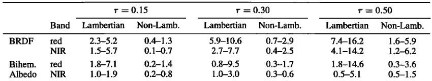
shows the ranges of RMS error, in percent, that were ob- served for these cases for different optical depths, and when using a Lambertian assumption for atmospheric correction and when not, performing a one-step iteration. Results are given for the red and near-infrared wave bands and for the surface B RDF and the bihemispherical integral of the B RDF (the white-sky albedo). In both cases the errors which arise clearly increase with optical depth but are noticeably smaller in the non-Lambertian case when compared to that using the Lambertian assumption. Employing an isotropic surface reflectance in atmospheric correction, errors in the surface reflectance between about 2 and 16 % are made. A one-loop correction, however, reduces the errors to a range from 1
to 3 % in all but the most turbid case, where the errors are also reduced considerably. The situation is similar with the
bihemispherical reflectance. The error made is reduced by a significant factor if a one-step iteration loop is performed.
These results show clearly that errors of up to 10 %, and at some angles and under turbid conditions more, occur if B RDF effects are not taken into account in atmospheric cor-
rection. The difference between the first and the second
iteration in the turbid case of the study of Vermote at al. [1995] illustrates that even using a BRDF that is only ap- proximately correct can be improved upon noticeably by using a BRDF that is closer to the real anisotropy. The con-
clusion from all the studies is that it is worthwhile, even
necessary, to use B RDF corrections in atmospheric correc-
tion, unless the conditions are not very turbid. It also is
clear that the size of the error that remains depends on the accuracy of the BRDF used. However, an iteration in one or two steps leads to sufficiently accurate results and should therefore always be carried out in operational atmospheric
correction where B RDF information is available. Given the
central importance of surface reflectance to most of the goals
Table !. Percent RMS Error Ranges in BRDF and Bihemispherical Albedo Retrieval Using Lambertian and Non-Lambertian Assumptions in Atmospheric Correction and Different Optical Depths r
r = 0.15 r = 0.30 r = 0.50 Band Lambertian Non-Lamb. Lambertian Non-Lamb. Lambertian Non-Lamb. BRDF red 2.3-5.2 0.4-1.3 5.9-10.6 0.7-2.9 7.4-16.2 1.6-5.9
NIR 1.5-5.7 0.1-0.7 2.7-7.7 0.4-2.5 4.1-14.2 1.2-6.2 Bihem. red 1.8-7.1 0.2-1.4 0.8-9.5 0.3-1.7 1.8-14.6 0.3-3.6 Albedo NIR 1.0-1.9 0.2-0.8 1.0-3.0 0.3-0.6 0.5-5.1 0.5-1.5
The ranges given correspond to three different shapes of the bidirectional reflectance distribution function (BRDF)' one that is dominated by volume scattering, one that is dominated by surface scattering, and one that is a mix of the
17,146 WANNER ET AL.: GLOBAL BRDF AND ALBEDO FROM MODIS
to be achieved in optical remote sensing, this implies that deriving a BRDF/albedo product is key to obtaining accurate results from remotely sensed optical data.
This brief review has focused on the specific case of the atmospheric correction problem. However, by implication, similar effects are to be expected in principle for radiation budget studies and the radiation treatment in climate and weather models. Clearly, the anisotropic nature of the re- flectance of the Earth's surface plays a role in shaping the energy flux in the atmosphere close to the surface and needs to be taken into consideration in any surface data retrieval or radiative tranfer modeling.
2.4. Albedo
As a consequence, current methods for estimating albedo from land cover properties or radiation flux budgets will be replaced by albedo products derived from directional re- flectance measurements utilizing BRDF models of the land surface, such as the MODIS BRDF/albedo product. These new products will also have the advantage of having much finer spatial resolution than that of current data (2.50 x 2.50 for ERBE; 1 o x 1 o for the ISLSCP database). This will al- low not only a closer correlation of albedos with land cover classes, which is needed for parameterizations in the land surface schemes of climate models, but also quantifications of subgrid variability and derivation of better coarse-scale
averages.
Integrals of the B RDF play a role beyond that of atmo- spheric correction. Accurate global albedo values are re- quired for global and regional climate and climate change studies. Zhang et al. [1995] point out that over land the average shortwave reflectivity of clouds is only 1.5 times higher than that of the surface, making surface albedo an im- portant influence. These authors go on to state that current uncertainty in land surface albedo is more important than current uncertainty in cloud albedo with respect to determin- ing net surface shortwave fluxes. With respect to climate
models, Henderson-Sellers and Wilson [1983] state that an
absolute accuracy of 5 % is required for a global albedo data set. The albedo values used by different climate models for identical regions still differ by several percent (see Li and Gatand [ 1994] for an overview). Gutman [ 1994] addresses the problem that albedo over dark targets, like rain forests, is more problematic than over land covers with higher reflec- tivity, and that errors here can easily be 20 %. Sellers [ 1993] cites a need for a 2 % absolute accuracy for global albedo in climate models. Meeting this need for accurate albedo data is a prime objective for remote sensing, one that has not been fully met up to date.
In attempts to bridge this gap, global albedo has been de- rived using a number of techniques utilizing radiation flux and budget assessments but hitherto not from bidirectional re- flectance distribution functions. Zhang et al. [1995] assume LambertJan reflectance in their study of surface and top-of- atmosphere radiative fluxes. The albedos used are based on a few land cover classes and wind speeds over oceans and are given as a function of solar zenith angle and season. Dropping the Lambertian assumption will be the obvious next step in the development. A method also discussed by Zhang et al. [ 1995] is to use albedos derived from the Earth radiation budget experiment (ERBE) to fit measurements at hand, depending on land cover type. Li and Garand [1994]
investigate
deriving
surface
albedo
from top-of-atmosphere
albedos in a clear sky situation and find an accuracy of a few percent. They point out that bidirectional effects have notbeen
given
proper
attention
even
though
they
are among
the
decisive factors in determining surface albedo from satellitemeasurements. These authors also use a Lambertian albedo for the land surface. The albedos of the International Satel-
lite Land Surface Climatology Project (ISLSCP) data sets
3. MODIS BRDF/Albedo Product
3.1. Product Outline
The MODIS BRDF/albedo product will provide the full surface BRDF as well as black-sky (directional) and white- sky (diffuse) albedos, these being intrinsic surface albedos. It will be produced globally (over land surfaces only) from a combination of MODIS and MISR data, at a spatial resolu- tion of 1 km. BDRF and albedos will be provided in seven spectral bands ranging from 0.47 to 2.13 ttm [see Running et
al., 1994]
and
in three
broadbands
ranging
from
0.3 to 0.7ttm,
from 0.7 to 3.0 ttm, and from 0.3 to 3.0 ttm. The product
will be produced
once
every 16 days
(the EOS AM-1 plat-
form and MISR 2-look repeat rate) and will be based on the semiempirical Ambrals BRDF model [Wanner et al., 1995a;Strahler
et al., 1996b;
Lewis,
1995].
Results
from
inverting
the empirical modified Walthall BRDF model [Walthall et al., 1985; Nilson and Kuusk, 1989] will also be recorded. A separate quarter-degree resolution product will be providedfor global
modeling
purposes.
This product
will also
carry
information
on sub-scale
variability.
Principal
Investigators
on the MODIS BRDF/albedo product are A. H. Strahler ofBoston
University
and J.-P.
Muller of University
College
London.
3.2. Angular Sampling From MODIS and MISR
Two
key issues
for a BRDF/albedo
product
are
the angular
sampling coverage available and the expected rate of loss ofangular
data
due
to cloud
cover.
Angular
sampling
is given
by instrumental
and orbital
characteristics
[Barnsley
et al.,
1994]. The EOS AM- 1 platform carrying both MODIS andMISR will have
a polar
orbit
with
a 1030
morning
equatorial
crossing time. The PM- 1 platform, to be launched in the year2000 with a second
MODIS sensor,
will have
a 1330
early
afternoon crossing time. Data from this second MODIS willbe included
in the MODIS BRDF/albedo
processing
chain
when it is available.The MODIS sensor will image the Earth's surface across track with a swath width of 2330 km [Running et al., 1994]. The viewing zenith angle will vary between 4-550 , or about
4-61ø
at the surface.
The repeat
cycle
is 2 days
at most
and
less than 1 day at latitudes greater than about 30 ø. Orbital[Sellers
et al., 1994]
are
derived
using
a two-stream
approx-
overlap
thus
makes
it well
suited
for
accumulating
multiangle
imation.
Problems
with
directional
effects
in AVHRR
data reflectance
data
over
a period
of time. Spatial
resolution
at
WANNER ET AL.: GLOBAL BRDF AND ALBEDO FROM MODIS 17,147
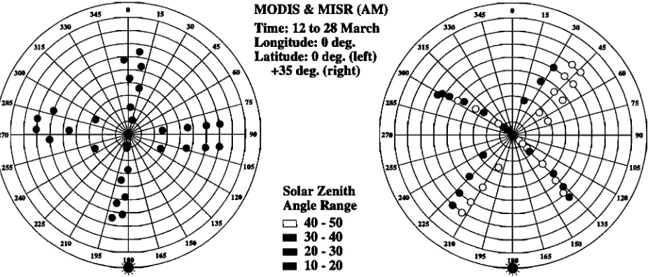
Time: 12 to 28 March
Longitude: 0 deg. Latitude: 0 deg. (left)
+35 deg. (right)
Solar Zenith
Angle Range
r• 40- 50 / 30 - 40 I 20- 30 / 10-20
Figure
1. Distribution
of observations
from moderate
resolution
imaging
spectroradiometer
(MODIS)
and
multi-angle
imaging
spectroradiometer
(MISR) in the viewing
hemisphere.
The time
period
is March
12 - 28(16
days).
The left plot is for the equator;
MODIS observations
are close
to the principal
plane;
MISR observations
are on the cross-principal
plane. The right plot is for a latitude
of 350 north;
both
MODIS and MISR are sampling away from the principal plane, with MISR a little closer to it. Farther north, MISR is closer to the principal plane. The solar zenith angle range in both cases is about 150 . Dataand
plots
produced
by the Xsatview
software
(M. Barnsley
and
K. Morris,
University
College
London)
from approximate representations of the satellite orbits.
MISR will image along track using nine separate push
broom cameras [Diner et al., 1991]. Four of these are aft
looking, four fore pointing, and one is nadir viewing. Ob- servations will be made in four spectral bands at visible and near-infrared wavelengths that are similar to those of MODIS. The potential spatial resolution of MISR observa-
tions is 275 m, but data will be made available at a standard
spatial resolution of 1.1 km. MISR's swath width is 364 km, allowing for a 9-day global repeat cycle, with the two-repeat cycle being 16 (not 18) days at the equator.
Angular sampling sufficient for BRDF model inversions will be achieved by combining data from MODIS and MISR in the four corresponding spectral bands and by accumu- lating data over a period of 16 days. In the absence of clouds this leads to between 30 multiangular observations available at the equator and about 55 observations at 600 latitude, subject to variation with season. Using a coarse statistic of mean global cloud cover probability [Wylie and Menzel, 1989; Wylie et al., 1994] as a function of latitude, one may predict that generally, about 15 to 20 multiangular observations will be available at all latitudes except at the equator, where abundance of cloudy conditions is likely to create problems.
With this number of observations available, on the aver-
age, sufficient angular coverage for a BRDF model inversion is to be expected in most cases. Since MODIS scans across track and MISR along track, the respective views will gen- erally represent different parts of the BRDF [Barnsley et al., 1994]. When one sensor views the cross-principal plane of the B RDF, the other views the principal plane, and vice versa. Figure 1 illustrates this, showing two typical cases for a particular latitude and time of year. With two sweeps across it, sampling of the viewing hemisphere is good in all
cases. Sampling of the illumination hemisphere, however, is limited. Any one string of MISR data is acquired for only one solar zenith angle, while the MODIS observations dis- play a small but valuable variation in that angle during the sampling period.
3.3. Kernel-Based Semiempirical BRDF Models
The MODIS BRDF/albedo product will be based on a semiempirical, kernel-based modeling approach introduced by Roujean et al. [1992] for top-down BRDF modeling. Mathematically, this type of model has the following form (here using two kernels and a constant):
IZ(Oi,
Ov,
C•)
= fi + fvkv(Oi,
Ov,
c•) + fsks(Oi,
Ov,
c•), (7)
where R is the reflectance, kv and ks are kernel functions, and f are the weights of these functions (the model parameters). The kernels depend only on the viewing and illumination geometry. They describe basic B RDF shapes into which the full BRDF may be decomposed.
17,148 WANNER ET AL.' GLOBAL BRDF AND ALBEDO FROM MODIS
such as leaf area index, shape and height of trees, surface reflectance, etc. Through inversion, however, only the three quantities f are retrieved, providing the relative influence of the respective type of scattering on the directional signal ob- served and allowing a rough characterization of the structural
characteristics of the surface observed.
The kernel-based approach to B RDF modeling has been
discussed
and
justified
by
Roujean
et al. [ 1992]
and
Wanner
et
al. [ 1995a].
Depending
on
the
scene,
it may
be
understood
in different
ways.
In a mixed
scene
composed
of two
areas • 0
with
different
BRDFs,
for
example,
a grassland-forest
mixed
pixel,
the
superposition
represents
the
respective
areal
con- • -1
tributions of the mainly shadow-driven (geometric-optical) BRDF of the forest and the turbid medium-type B RDF of the -2 grassland. Adjacency effects are neglected, which is admis- sible unless the mosaic is very fine or the zenith angle very -3 large. However, even in a homogeneous scene, volume and surface scattering may still be both present. For example, in a forest canopy the geometric scattering is given by the inter crown gaps, whereas the volume scattering is given by the gaps between the leaves. The superposition then describes
first-
and
second-order
scattering,
while
neglecting
the
cou-
3
pling of the two. From a practical standpoint it is perhaps
most
accurate
to say
that
the
BRDF
observed
is
decomposed
2
into the two components
represented
by the two basic
types
of scattering.
Volume
and
surface
scattering
produce
BRDF • 1
functions
that are semiorthogonal
due to an increase
in re-
flectance
with
zenith
angle
in the
former
and
a decrease
in • 0
the latter
case.
Kernel-driven
models
have
been
proven
successful
in
ap- • -1
plication
to AVHRR,
advanced
solid
state
array
spectrora- -2
diometer (ASAS), laboratory, and field-measured multian-
gular
reflectance
data
and
have
been
shown
to fit observed -3
BRDF data well [ Roujean et al., 1992; Leroy and Roujean,
1994; Wu et al., 1995; Wanner et al., 1995b; Privette and
Vermote, 1995; Strahler et al., 1995b; Li et al., 1996; Barns- ley et al., 1997a; Hu et al., 1996; White et al., 1996]. Some examples of the latter will be given in section 5. A kernel- based model is also being used for the BRDF/albedo product of the polarization and directionality of the Earth's radiation (POLDER) project [Deschamps et al., 1994; Leroy et al., this
issue].
3.4. Ambrals BRDF Model
The kernel-based B RDF model to be used for produc- tion of the MODIS B RDF/albedo product was chosen to be the Ambrals BRDF (Algorithm for MODIS bidirectional re- flectance anisotropy of the land surface) B RDF model, as defined by the kernels used in it. The rationale for choos- ing this model is given in section 3.5. The kernels used are based on theory by Roujean et al. [1992], Ross [1981], Li and Strahler [ 1992], Li [Strahler et al., 1994; Wanner et al., 1995a], and Cox and Munk [ 1954].
The Ambra!s model provides two choices each for the volume scattering and for the surface scattering kernel. The kernels to be used in a particular case depend on the charac- teristics of the multiangular observations available. The two kernel expressions derived for volume scattering are based on two different approximations to a single-scattering ra-
Principal Plane Values of Kernels
Solar Zenith Angle 0 Degrees
... ;' ß
/
\'\
,/
---
-
/
-75 -50 -25 0 25 50 75
View Zenith Angle
Solar Zenith Angle 30 Degrees
' /
\ ß
\
ß '• ... '•. ---, .b--• ... 1
./
\
-75 -50 -25 0 25 50 75
View Zenith Angle
Solar Zenith Angle 60 Degrees
2
///
• 1 • \ ,-', %. I .'ø
• [ •. ß •. L. -•
/
5
I
/%_/
l,'
',
/
/
x--
...
...
-75 -50 -25 0 25 50 75
View Zenith Angle
Figure 2. Principal plane values of the kernels for three different solar zenith angles. Dashed-dotted curve, Ross-
thin;
dashed
curve,
Ross-thick;
short-dashed
curve,
specular;
solid
curve,
Li-dense;
long-dashed-dotted
curve,
Li-sparse.
The
Li-sparse
kernel
is calculated
for b/r = 1 and
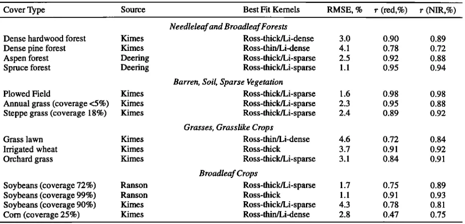
h/b = 2
WANNER ET AL.: GLOBAL BRDF AND ALBEDO FROM MODIS 17,149
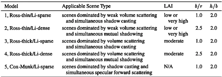
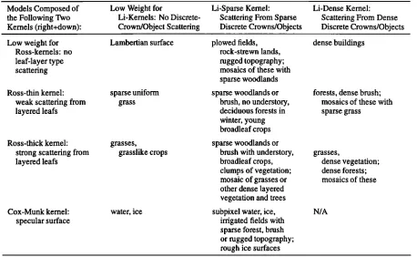
Table 2. Ambrals Model Kernel Combinations to be Used in Generating the MODIS
BRDF/Albedo Product
Model Applicable Scene Type LAI b/r h/b
1, Ross-thin/Li-sparse scenes dominated by weak volume scattering low or 1.0 2.0 and simultaneous shadow casting very high
scenes dominated by weak volume scattering low or 2.5 2.0 and simultaneous mutual shadowing very high
scenes dominated by volume scattering moderate 1.0 2.0 and simultaneous shadow casting
scenes dominated by volume scattering 2.5 2.0 and simultaneous mutual shadowing
qr•n•q dorninato. d hv qhadow casting and 1 13 9. 13 simultaneous specular forward scattering
2, Ross-thin/Li-dense
3, Ross-thick/Li-sparse
4, Ross-thick/Li-dense moderate
q, c'r,•-Munk•_•.i- ?a rqo N/A
MODIS, moderate resolution imaging spectroradiometer. Note that for each kernel combination the
weights attributed to the individual kernels can still range from making volume scattering dominant over
surface scattering or vice versa. This may be due to the respective areal proportions of the scene components, or to a mix of the two scattering types in a homogeneous scene.
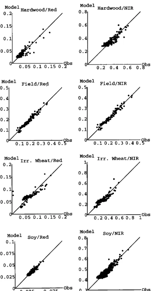
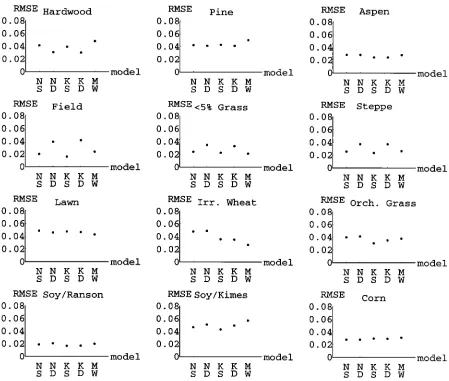
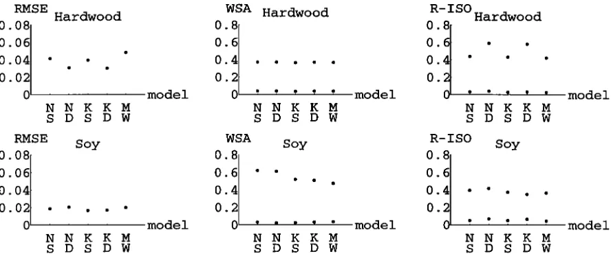
diative transfer theory of Ross [ 1981], one for large values the kilometer scale. The Ross-thin kernel is combined with of the leaf area index ("thick" approximation) [Roujean et either the Li-sparse or the Li-dense kernel, as is the Ross- al., 1992], and one for small values ("thin" approximation) thick kernel. The Cox-Munk kernel is combined with the [Wanner et al., 1995a]. For geometric surface scattering, Li-sparse kernel. These five model variants, also listed in two types of Li kernels are available. These were derived Table 2, will be used to produce the MODIS BRDF/albedo from the geometric-optical mutual shadowing B RDF model product. Tests have shown that for a variety of land cover for forest canopies by Li and Strahler [1992]. The first of types at least one of these models provides a good fit, al- these is an approximation for "sparse" spacing of discrete though for some land cover types, several models may do objects (crowns) and the second for "dense" spacing of ob-
jects (crowns) [Strahler et al., 1994; Wanner et al., 1995a]. The Li-sparse kernel is mainly driven by the way shadows emerge and are hidden in the scene, while the Li-dense kernel is dominated by the sunlit crowns as seen under conditions of mutual shadowing in both viewing and illumination direc- tions. For MODIS B RDF/albedo processing, the Li-sparse kernel is formulated to represent spheroids that are relatively close to the ground (b/r = 1, h/b = 2, where b is the
crown vertical radius, r the crown horizontal radius, and
h the height to center of crown). The Li-dense kernel is formulated to represent prolate crowns that are located some distance above the ground (b/r - 2.5, h/b - 2). For general use of the Ambrals model, other choices of these parameters
can be made.
In cases where the forward scattering direction of the BRDFhas been sampled, a Cox-Munkkernel has been devel-
well due to the fact that they share the kernel that accounts for most of the B RDF shape (see section 5 of this paper and
Wanner et al. [1995b] and Hu et al. [1996]).
3.5. Rationale in Choosing the Ambrals BRDF Model
Quite a number of B RDF models are available in the lit-
erature, ranging from simple empirical to rather complex numerical models that more closely represent the physical features of the plant types being modeled (Strahler [1994] gives an overview). The majority of these were derived from aforward modeling perspective. Geometric and optical prop- erties of vegetation are used to compute the most prominent features of radiation scattering and shadow casting in plant canopies and to derive the BRDF. While being very valuable in providing an insight into the physics of the interaction of light with vegetation, they are not ideally suited for re- mote sensing applications. Forward modeling represents a
oped
[Strahler
et al., 1995a,
update]
to model
contributions
bottom-up
approach,
while remote
sensing
requires
dealing
from subresolution water bodies, flooded fields, and meltingice. This kernel is based on a theory of Sun glint on the ocean by Cox and Munk[1954]. A wind speed parameter of 5 rn/s
is used.
Figure 2 shows the shape of these five Ambrals model kernels on the principal plane for three different solar zenith angles. Kernels may be normalized before use to have com- parable ranges of values or integrals. Note that volume scat- tering and surface scattering kernels are, to a large degree, linearly independent.
with the inverse problem. The perspective that needs to be at the core of the modeling is top-down.
The rationale for choosing the Ambrals B RDF model for the operational inversions of MODIS BRDF/albedo process- ing is outlined by four requirements that were met by this
model.
17,150 WANNER ET AL.: GLOBAL BRDF AND ALBEDO FROM MODIS
surfaces. This, to some extent, precluded the use of just one curately the radiative fluxes at the time of observation, is not
single
BRDF model
for all land
cover
types.
directly
usable
in biospheric
and climate
modeling,
where
The Ambrals model meets these requirements in that the the atmosphere applied and/or computed may be different inversion of three parameters is achievable from the avail- from that observed and may vary as a simulation proceeds.
able
multiangular
sampling
and
that
no additional
parameters
What
is needed
for modeling
is an average
or hemispherical
need
to be predetermined.
It has
been
successfully
applied
to reflectance
in form of an intrinsic
surface
property
that
is not
a number of observed BRDF data sets [Privette and Vermote, dependent on a particular atmosphere and time.1995; Strahler et al., 1995b; Wanner et al., 1995b; Hu et al., In order to meet this demand, the MODIS BRDF/albedo 1996; White et al., 1996]. A similar model is to be used for product will provide two measures of albedo in the form operational B RDF retrievals or POLDER [Leroy et al., this
issue].
2. The model used should be robust in several respects.
It should
be robust
with regard
tO inversion
from limited
angular sampling and robust against noise in the input data. It is essential that it should not assume that the pixels viewed possess a homogeneous land cover (an assumption implicit in most B RDF models). Globally, the number of mixed pixelsof the directional-hemispherical and bihemispherical inte- grals of the BRDF, derived through the Ambrals BRDF model from atmospherically corrected reflectances. These albedo measures then are intrinsic properties of the surface. They represent the following two cases. The directional- hemispherical integral (4), called the "black-sky albedo," represents the case of single-beam irradiation in the absence of diffuse skylight, i.e., the situation of a perfectly clear sky.
heterogeneous
at the 100-m-scale
is large. Also the BRDF The bihemispherical
albedo,
called
the "white-sky
albedo,"
model needs to be able to model BRDF effects caused by given by (6), with •7 replaced by pb and the integration overhilly and
rugged
topography
and
by rough
soil surfaces.
0s, represents
the case
of perfectly
diffuse
illumination,
i.e.,
Because of the top-down modeling approach taken in the case of a perfectly turbid atmosphere, similar to an over- kernel-driven models, discussed in the previous section, the cast situation. The albedo under conditions of atmospheric Ambrals BRDF model meets these requirements well. Noise scattering of light will then be a value between these two ex- sensitivity is discussed in section 3.7. treme cases and will depend on the actual aerosol and water3. There should be a mathematically clear way of scaling vapor loading. the model, and hence the derived data product, across a range
of spatial scales. The MODIS BRDF/albedo product will be generated at a spatial resolution of 1 km, but the results may be applied at coarser resolutions up to climate-model resolutions of, e.g., 2.5 ø. Since the BRDF is a nonlinear function of at least three angles, such spatial scaling is not a straightforward operation and neither is the spatial averaging of albedos when taking a varying BRDF effect into account. The Ambrals model scales spatially due to its linear prop- erties: the parameters of the model at a coarser spatial scale may be expressed through weighting of the parameters of
It may be noted that the black-sky albedo is a function of solar zenith angle, whereas the white-sky albedo is a constant. It is an advantageous property of kernel-based models that the black-sky albedo may be formulated as a linear combination of the BRDF model parameters and the black-sky integrals of the kernels. Since these integrals may be precomputed and tabulated, the black-sky albedo can be generated from known model parameters at any solar zenith angle without numerical integration [Lewis, 1995] using a very compact lookup table that will be provided with the product.
Black-sky and white-sky albedo will be given in all seven
each
kernel
according
to their
proportion
of area.
This
will MODIS
land
bands,
spanning
from
0.47 to 2.13
ttm. They
allow
degrading
the MODIS BRDF/albedo
product
to any will also
be derived
in three
broadbands,
from
0.4 to 0.7 ttm,
resolution
desired
for a specific
modeling
purpose.
0.7 to 3.0 ttm, and
0.4 to 3.0 ttm,
which
are
useful
to climate
4. The model
must
have
a speedy
inversion.
This pre- modeling,
where
the wavelength
domain
is commonly
par-
cludes
the use of numerical
inversion
techniques,
typically titioned
in this
manner
[Dickinson,
1983]. In the shortwave
required
for the inversion
of physical
and
numerical
BRDF region,
vegetation
dominantly
absorbs
radiation,
whereas
in
models
[cf. Goel, 1989]. Currently,
only
a model
that
has
a the longerwave
region,
it is mainly
scattered.
Broadband
mostly analytical inversion is a feasible candidate.The Ambrals model may be inverted analytically by solv- ing the set of linear equations derived from minimizing an appropriate error function through matrix inversion [Lewis, 1995]. The model inverts extremely rapidly for this rea- son and is consequently ideally suited for large-scale global
BRDF inversion.
3.6. Albedo From MODIS
The influence of atmospheric state on the radiative fluxes at the surface becomes an issue when deriving albedo. Albedo
albedos are not simply spectral averages of the albedo. They are defined such that given a downwelling broadband flux, the corresponding broadband upwelling flux is derived.
Narrowband-to-broadband albedo conversion will be per- formed by weighting the narrowband albedos by their as- sociated proportion of downwelling solar irradiance. This
method has been used with nadir Landsat measurements
[Brest and Goward, 1987] and was shown to be satisfac-
WANNER ET AL.: GLOBAL BRDF AND ALBEDO FROM MODIS 17,151
Table 3. Spectral-to-Broadband Albedo Conversion: Accuracy of Results Based on Seven-Band Splines As Compared to Exact Results
Exact Results Band-Based Deviations
Cover Total Vis IR Total Vis IR
Type 0.4-2.2t•m 0.4-0.7t•m 0.7-2.2t•m 0.4-2.2t•m 0.4-0.7t•m 0.7-2.2t•m
Grass 0.22 0.058 0.34 -0.9% +0.5% -1.2% Soil 0.18 0.10 0.24 -0.4% -3.2% +0.4% Snow 0.84 0.99 0.72 -2.1% -0.2% -4.0%
researchers will always be able to carry out their own con-
versions.
Table 3 shows sample results illustrating the potential ac- curacy achievable in narrowband-to-broadband albedo con- version using the seven MEDIS land bands for three differ- ent land cover types. The broadband albedos derived from splines to the spectral values are within 1 or 2 % of the real
values.
Angular Sampling and Noise
The behavior of the Ambrals BRDF model under inversion
was studied in detail under conditions of angular sampling as expected from MEDIS and MISR. Two types of studies
("extrapolation"). White-sky albedo and the model parame- ters themselves were also investigated.
The noise sensitivity study was carried out by taking advantage of the linear mathematical properties of kernel- driven models that allow an analytical analysis following methods developed by Gauss [Whittaker and Robinson, 1960]. The diagonal elements of the inversion matrix found in the minimization problem, which depend only on the ker- nel values at the angles sampled, may be used to compute so-called "weights of determination," or "noise inflation fac-
tors" [Wanner et al., 1996]. These factors indicate how
random uncertainty in the reflectances sampled translates
into uncertainty in the B RDF and in albedo. Noise infla-
tion factors depend on the sampling geometry alone, that were carried out. The first is a study of the influence of is, for MODIS and MISR sampling they vary with latitude random noise on the accuracy of the inversion. The second and time of year, but for kernel-based models, they do not is a study of how well a BRDF derived from a limited set of depend on wavelength or the type of BRDF viewed. The angular reflectances interpolates and extrapolates to angles study conducted shows that both interpolated and extrapo- not observed. Both of these extensive studies will be reported lated nadir-view reflectances and black-sky albedos as well in full detail elsewhere. Here, only a brief overview over the as the white-sky albedo have median noise inflation factors main results can be given. of less than 0.5 and worst values of less than about 1, demon-
Both the noise sensitivity and the interpolation/extrapola- strating that the inversions are stable with respect to random tion accuracy study were conducted using simulated 16-day noise.
MEDIS and MISR cloud-free viewing and illumination ge- In the presence of clouds these factors are expected to ometries simulated by the Xsatview software by Barnsley increase with the square root of the number of observa- and Morris [Barnsley et al., 1994]. Investigations were car- tions, provided that the angular coverage of the samples ried out as a function of latitude and day of the year. The does not change significantly. A comparison of the Am- quantities studied were nadir-view reflectance and black-sky brals noise sensitivity with the corresponding sensitivity of albedo at the prevailing mean Sun angle of observations ("in- the semiempirical three-parameter BRDF model by Rahman terpolation") and for a fixed nadir or 10 ø Sun zenith angle et al. [1993] shows that both models behave very simi-
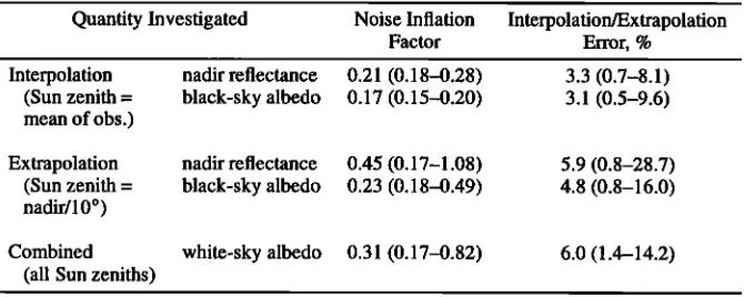
Table 4. Expected BRDF/Albedo Product Accuracy: Median Values and Ranges for 16-Day MEDIS and MISR Sampling at Different Latitudes and Times of Year
Quantity Investigated Noise Inflation Interpolation/Extrapolation
Factor Error, %
Interpolation nadir reflectance 0.21 (0.18-0.28) 3.3 (0.7-8.1) (Sun zenith = black-sky albedo 0.17 (0.15-0.20) 3.1 (0.5-9.6) mean of obs.)
Extrapolation nadir reflectance 0.45 (0.17-1.08) 5.9 (0.8-28.7) (Sun zenith = black-sky albedo 0.23 (0.18-0.49) 4.8 (0.8-16.0) nadir/10 ø)
Combined white-sky albedo 0.31 (0.17-0.82) 6.0 (1.4-14.2) (all Sun zeniths)
17,152 WANNER ET AL.: GLOBAL BRDF AND ALBEDO FROM MODIS
larly. The study was also carried out using MeDIS-only and MISR-only sampling. Results demonstrated that the qual- ity of a MeDIS-only product is greatly enhanced by adding MISR data. The noise inflation factor may be used as a quan- titative indicator of sampling quality in operational BRDF inversions and will be carried by the MEDIS BRDF/albedo product.
For the interpolation and extrapolation error study, a
three-dimensional discrete ordinate numerical BRDF for-
ward model by Myneni et al. [1992] was used to create surface reflectances at the angles sampled by MEDIS and MISR over 16 days. The study was carried out for BRDFs of six different biome types (grassland, shrubs, broadleaf crops, savanna, broadleaf forest, conifers) and for red and near-infrared wavelengths. Upon inversion of the Ambrals BRDF model results were compared with those known from the forward model. At the mean Sun zenith angle of the ob- servations the predicted nadir view reflectance and black-sky
albedo were found to have a median deviation from the true
value of about 3 to 4 %. At a Sun zenith angle of 10 ø, re-
flectance showed a median deviation of about 6 %, whereas
black-sky albedo was accurate to about 5 %. This shows that while interpolation can be carried out with good pre- cision, extrapolation depends more on favorable sampling conditions. White-sky albedo could be determined with a median accuracy of 6 %. Since these numbers are the results of model-to-model comparisons, they should be interpreted with caution; problems can be due to either model. In cases with unfavorable sampling, errors of up to 10 or 20 % may
occur.
Table 4 summarizes the noise sensitivity and the interpo- lation/extrapolation study results. The results in both cases are medians over all cases investigated. The ranges given
are chosen to include two thirds of all relevant data.
4. Algorithm
4.1. BRDF/Albedo in the MODIS Production Chain
The MEDIS BRDF/albedo product is generated as part of the surface reflectance processing chain for the MEDIS instrument, which runs from calibration and geolocation through atmospheric correction, gridding, and resampling to B RDF and albedo retrieval. The latter relies on atmospher- ically corrected surface reflectance data from both MEDIS and MISR and atmospheric coupling descriptors for updat- ing atmospheric corrections where necessary after the initial BRDF retrievals. Product generation is supported and gaps are filled by having available current land cover and topo- graphic information, the BRDF/albedo results from the pre- vious production cycle, and a global database of accumulated BRDF/albedo knowledge that will be built over time.
MEDIS level-2 reflectances that have been cloud cleared
and atmospherically corrected are binned into the MEDIS level-3 grid over a period of 16 days and combined with all MISR observations acquired during that time. The data are averaged to a spatial resolution of 1 km, where each observa- tion is weighted by the respective overlap between the grid cell and the observation footprint. Quality information asso- ciated with the data is translated to quality coefficients that
are used to weight individual observations in the subsequent BRDF inversion. This allows special consideration of data where, for example, atmospheric correction was difficult or
aerosol information was taken from standard tables because
no aerosol retrievals were available.
The directional observations thus assembled are then an-
alyzed by inverting the five model variants listed in Table 2
to find the Ambrals kernel combination that describes the
observations best. BRDF model inversion is carried out by straightforward matrix inversion [Lewis, 1995]. The four
bands common to MEDIS and MISR are inverted first. The
model chosen from this analysis is then applied to the three remaining bands, in which only MEDIS data are available. The model parameters found are then output along with ex- tensive quality control data and other information necessary for an assessment of the product. Integration of the BRDF is carried out to provide black-sky and white-sky albedos. Use of a digital terrain database will allow correction for BRDF effects created by topographic shading after the launch of AM-1 when a suitable global dataset is available. Initially,
the BRDF derived will characterize the combined BRDF of
vegetation/soil and topography.
The Ambrals model kernel combination that best describes the observations is selected from the five available model
variants as follows: Generally, the kernels to be used will be chosen to provide the fit with the smallest root band- averaged mean squared error (RMSE) when inverting the available multiangular surface reflectances. The two cases, where an exception is made are if the RMSE found is above a pre-determined threshold, or the angular sampling coverage is poor for reliable inversion, either because observations span only a small angle range or the number of observations is too small. In these cases information from the supporting ancillary databases is used to limit the inversion. If angular sampling is good but the RMSE found is high, the kernel combination suggested by the ancillary data (previous BRDF, BRDF accumulated database, land cover type, topography) is used instead of the best fitting model variant if the resulting RMSE is not much worse. The model parameters are still
derived from a full inversion of the reflectances.
If angular sampling is bad or the number of reflectances
available is too small, a full inversion cannot be trusted and
gaps in the product would result. In this case, the BRDF kernel combination and model parameters suggested by the ancillary databases will be used, but the magnitude of the BRDF (the isotropic constant of the model) will be adjusted to the observed reflectances. Through this the shape but not the magnitude of the B RDF will be fixed. This procedure also guarantees that the reflectance information available in cases not permitting a full BRDF inversion will not be simply lost but used to the extent possible.
In each case, the source of the resulting BRDF information will be recorded so that users can filter the output according to their needs. The ancillary database accumulating BRDF knowledge over time, keyed by season, and the relationships between land cover type and BRDF used will be established post launch from the observed data and updated at intervals.
Since the Ambrals model allows different kernels to be